December 02 , 2023.
Italy / Sicily , Etna :
Press release on the activity of Etna, December 1, 2023 6:33 p.m. (5:33 p.m. UTC).
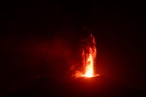
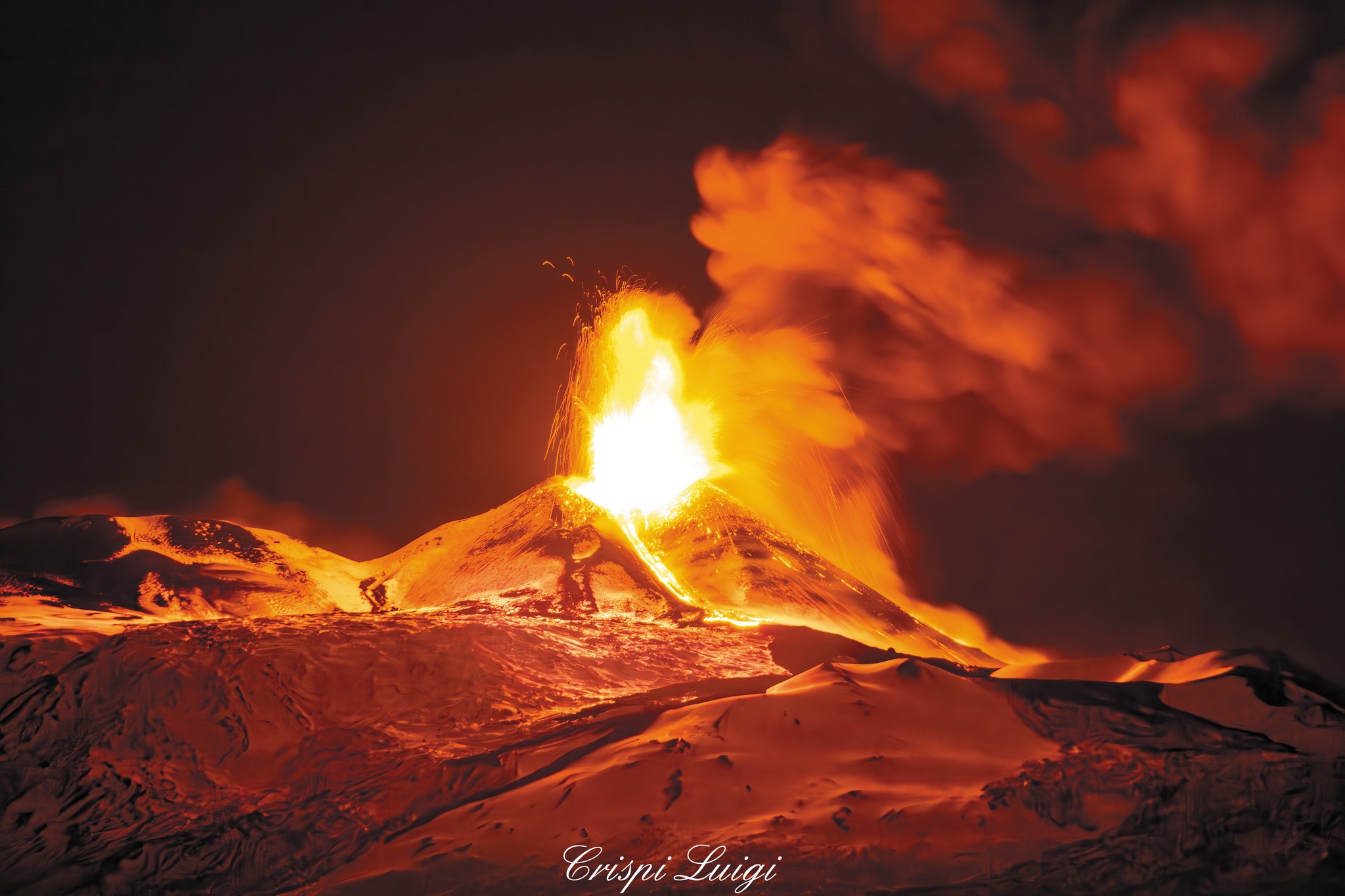
The National Institute of Geophysics and Volcanology, Osservatorio Etneo, communicates that according to the analysis of images from the surveillance camera network, a lava fountain is underway at the Southeast crater. The forecast model on the dispersion of the volcanic plume indicates a potential fall of ash on the northeast side of the volcano in a north-northeast direction.
From a seismic point of view, compared to the previous statement, the average amplitude of the volcanic tremor has further increased, with an upward trend. The sources of tremors remain confined at depth to the Southeast crater area, at approximately 2900 m altitude. Infrasound activity also shows a significant increase. Localized infrasound events are produced by the Southeast crater. The analysis of inclinometer data shows a variation of approximately 0.3 micro radians in the summit part of the volcano, compatible with the usual dynamics of a lava fountain.
Press release on the activity of Etna, December 1, 2023, 11:32 p.m. (22:32 UTC).
The National Institute of Geophysics and Volcanology, Osservatorio Etneo, communicates that the activity of the lava fountain at the Southeast crater ended around 8:35 p.m. (GMT). The eruptive activity at its peak produced an eruptive column up to approximately 6000 m altitude, with dispersion in the northeastern quadrants of the volcano. Reports of ash fall have been received from the towns of Fiumefreddo, Calatabiano and Giardini Naxos. The lava fountain was accompanied by effusive activity which created two lava flows which spread from the Southeast crater to the South and East.
From a seismic point of view, the average amplitude of the volcanic tremor, after reaching maximum values around 19:30 UTC, showed a clear downward trend and around 21 UTC it reached the range of average values, where it still maintains itself. The sources of the tremor remain confined to the Southeast crater area, at a depth of approximately 3000 m above sea level. Infrasound activity also showed a significant decrease and around 8:30 p.m. UTC it almost completely disappeared. disappeared.
The inclinometer data show the start of the paroxysmal phenomenon around 16:50 UTC and the highest station, at 18:20 UTC showed a variation of more than 2 microradians. Analysis of dilatometric data (strain meter) also shows a variation from 4:50 p.m. UTC; at 8:05 p.m. UTC the signal indicates the end of the phenomenon and the global decompression reaches a value of approximately 197 nano-strain, corresponding to nearly 3 million cubic meters in eruption.
Further updates will be communicated shortly.
Source : INGV.
Photo : Crispi Luigi
United States , Yellowstone :
Friday, December 1, 2023, 9:20 AM MST (Friday, December 1, 2023, 16:20 UTC)
44°25’48 » N 110°40’12 » W,
Summit Elevation 9203 ft (2805 m)
Current Volcano Alert Level: NORMAL
Current Aviation Color Code: GREEN
Recent Work and News
Steamboat Geyser erupted on November 13—its 8th major water eruption of 2023. Since that time, the geyser has been quiet, with no minor eruptions.
Most roads in Yellowstone National Park are currently closed to prepare for the winter season and snowmobile and snowcoach travel, which will begin on December 15. The road between the North Entrance and the Northeast Entrance is open to regular vehicles year-round.
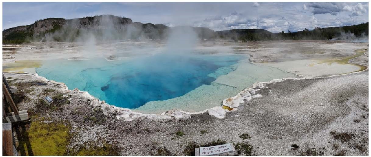
Sapphire Pool, an alkaline (pH ~7.5) spring in the Biscuit Basin area of the Upper Geyser Basin, Yellowstone National Park. The vent (top image) is hot (~80°C), with white silica precipitating,
Seismicity
During November 2023, the University of Utah Seismograph Stations, responsible for the operation and analysis of the Yellowstone Seismic Network, located 119 earthquakes in the Yellowstone National Park region. The largest event of the month was a minor earthquake of magnitude 2.8 located about 15 miles southeast of Mammoth, Wyoming, on November 10 at 10:16 PM MST.
November seismicity in Yellowstone was marked by two swarms:
1. A swarm of 27 earthquakes, located approximately 3 miles southeast of West Yellowstone, MT, occurred during November 19–30. The largest earthquake in the sequence was a magnitude 1.2 event on November 22 at 5:07 AM MST.
2. A swarm of 26 earthquakes, located approximately 11 miles south-southwest of West Thumb, WY, occurred during November 6–12, with the largest event of the sequence being a micro earthquake of magnitude 2.5 on November 6 at 8:42 AM MST.
Yellowstone earthquake activity is currently at background levels.
Ground Deformation
During the month of November, continuous GPS stations in Yellowstone caldera showed subsidence, which has been ongoing since 2015, interrupted in summer months by a pause or slight uplift caused by groundwater accumulation from snowmelt and runoff. Approximately 1.2 cm (0.5 in) of subsidence has occurred in the caldera since the end of September. Deformation at Norris Geyser Basin is following the same trend as the caldera, but with slightly lower magnitudes of change.
Source et photo : YVO
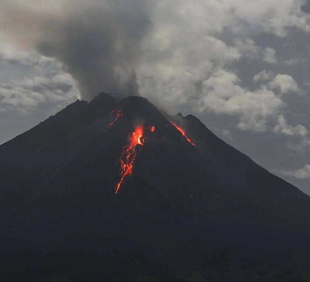
Indonesia , Merapi :
Report on the activity of Mount Merapi from November 24, 2023 to November 30, Published on December 1, 2023.
OBSERVATION RESULTS
Visual
The weather around Mount Merapi is generally sunny in the morning and afternoon, while the evening is foggy. White smoke, fine to thick, low to medium pressure and 75 m high was observed from the observation post of Mount Merapi in Badaban on November 27, 2023 at 6:45 a.m.
This week, 2 hot avalanches were observed, one towards the Boyong River up to 1500 m and one towards the Bebeng River, up to a maximum of 2000 m. Lava avalanches were observed 97 times towards the South and Southwest, including 20 times upstream of the Boyong River up to 1500 m and 77 times upstream of the Bebeng River up to a maximum of 1800 m. The sound of avalanches was heard 25 times from the Babadan post with low to moderate intensity.
Based on the analysis of aerial photos from November 16, 2023, the volume of the southwest dome was measured at 3,348,600 cubic meters and that of the central dome at 2,358,000 cubic meters.
Seismicity
This week, the seismicity of Mount Merapi showed:
2 warm cloud avalanche earthquakes (APG)
2 low frequency volcanic earthquakes (LF)
8 shallow volcanic earthquakes (VTB)
1592 multi-phase (MP) earthquakes,
980 avalanche earthquakes (RF)
5 tectonic earthquakes (TT).
The intensity of seismicity this week is lower than last week, but the number of earthquakes is still quite high.
Deformation
The deformation of Mount Merapi that was monitored using EDM this week showed a shortening of steepening distance of 0.1 cm/day.
Rain and lahars:
There was rain this week at Mount Merapi observation post in Kaliurang with an intensity of 132 mm/hour for 25 mins on November 30, 2023. There were no reports of additional flows or lahars from of rivers that descend from Mount Merapi.
Conclusion
Based on the results of visual and instrumental observations, it is concluded that:
-Mount Merapi’s volcanic activity is still quite high in the form of effusive eruption activity. The activity status is defined at the “SIAGA” level.
The current danger potential is in the form of lava avalanches and hot clouds in the South-South-West sector including the Boyong river for a maximum of 5 km, the Bedog, Krasak, Bebeng rivers for a maximum of 7 km. In the South-East sector, it includes the Woro river for a maximum of 3 km and the Gendol river for 5 km. While the ejection of volcanic material in the event of an explosive eruption can reach a radius of 3 km from the summit.
Source : BPPTKG.
Photo : Andi Volcanist
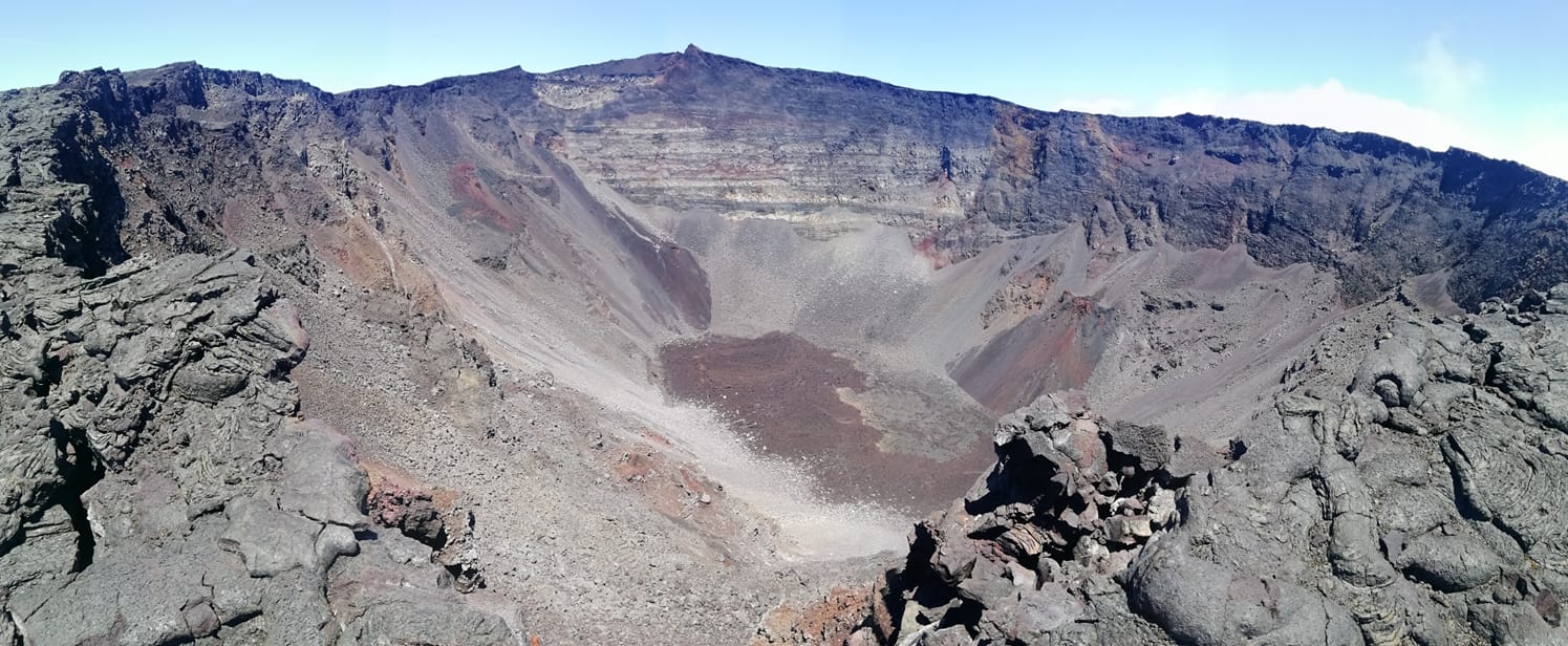
La Réunion , Piton de la Fournaise :
Monthly bulletin, Paris Institute of Globe Physics, Piton de la Fournaise Volcanological Observatory.
Seismicity
In November 2023, the OVPF-IPGP recorded in total at the Piton de la Fournaise massif:
• 17 superficial volcano-tectonic earthquakes (0 to 2.5 km above sea level) under the summit craters;
• 2 deep earthquakes (below sea level);
• 7 long-period earthquakes;
• 251 landslides.
The month of November 2023 will have been marked by low seismicity under the Piton de la Fournaise with an average of 0.6 superficial volcano-tectonic earthquakes per day. Two deep earthquakes were also recorded.
Only one deep earthquake could be located, to the west of the Bory crater. The others – of lower magnitudes – could not be located.
Numerous (251) landslides in the Dolomieu Crater, at the Cassé de la Rivière de l’Est and at the level of recent lava flows were also recorded.
Deformation
In November 2023, a resumption of peak inflation was recorded. The inflation rate is of the order of 2 cm of elongation at the summit zone in one month. This inflation is linked to the pressurization of a source under the Dolomieu crater at a depth of 1 – 2 km, corresponding to the depth of the superficial magmatic reservoir.
Balance sheet
In November 2023, a resumption of inflation was recorded at Piton de la Fournaise, testifying to a pressurization of the superficial magma reservoir. At the same time since mid-October, a new trend of increasing CO2 emissions has been recorded both in the distal field and in the proximal field.
On the other hand, seismicity remained low with an average of 0.6 superficial volcano-tectonic earthquakes per day under the summit craters.
Source et photo : OVPF.
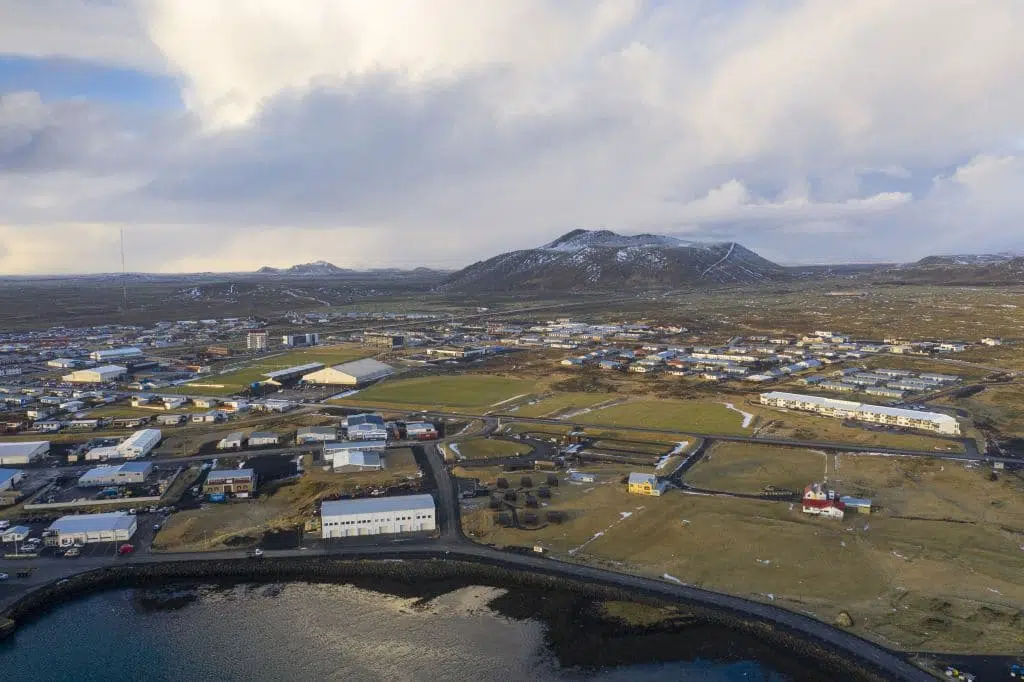
Iceland , Reykjanes Peninsula :
Seismic activity still decreasing . The unrest phase is not over, difficult to say when and where the next dike will propagate
Updated 1. December at 16:50 UTC
The seismicity on the peninsula continues to decrease. For the past few days, the automatic earthquake location system has been detecting relatively few earthquakes, mostly micro-earthquakes below magnitude one. The most recent seismicity is concentrated in the area between Sýlingarfell and Hagafell, where most likely the dike is fed by magma accumulating beneath Svartsengi. Some deformation is still detected at the cGPS stations located close to the dike, but the signal is now mainly interpreted as the response of the crust to the inflation ongoing in the Svartsengi area.
Source : OMI
Photo : Golli (Grindavík et la montagne Þorbjörn)