December 01 , 2023.
Costa Rica , Poas :
Location: N10.20 W84.23
Altitude: 2687 meters. (8813 feet)
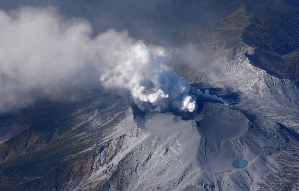
Date: November 29, 2023, 11:57 a.m.
Plume height (above crater): 164 feet. (50 meters)
Plume observation source: webcam, seismic recording, visitor report.
Activity observed:
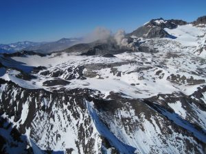
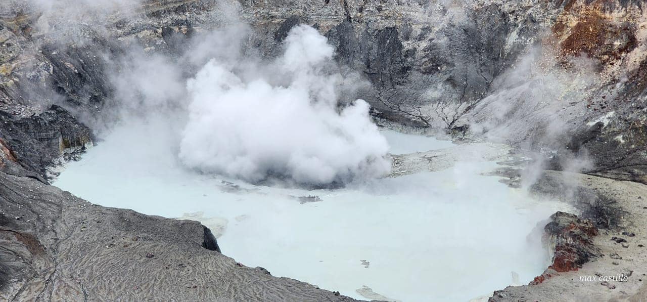
A small hydrothermal eruption is recorded at the Poás volcano at 11:57 a.m. The eruption released sediment from the bottom of the lake to a height of about 50 meters. No damage reported.
The plume appears to be rich in sediment from the lake bottom, water vapor and volcanic gases.
Activity Level: Warning.
The volcanic tremor remains of medium intensity and in a frequency band between 1.5 and 3.5 Hz. Several underwater fumaroles with intense activity are observed, including one with bubbling. No significant concentration of volcanic gases is recorded.
Source : Ovsicori
Photo : Max Castillo
Colombia , Nevado del Ruiz :
Weekly bulletin on the activity of the Nevado del Ruiz volcano
Regarding the monitoring of the activity of the NEVADO DEL RUIZ VOLCANO, the MINISTRY OF MINES AND ENERGY, through the COLOMBIAN GEOLOGICAL SERVICE (SGC), reports that:
In the week of November 21 and 27, 2023, the volcano continued to exhibit unstable behavior, characterized by low to moderate activity levels. Compared to the previous week, the main variations in the parameters monitored were:
– Seismicity linked to the activity of fluids inside volcanic conduits has increased in the number of earthquakes recorded and in the seismic energy released, notably from seismic signals associated with pulsatile emissions of ash and gas in the air.

– Seismic activity associated with the fracturing of rocks inside the volcanic edifice has decreased in the number of earthquakes recorded and increased in the seismic energy released. The seismicity was located mainly in the Arenas crater and on the different flanks of the volcano up to an approximate distance of 6 km from the crater. To a lesser extent, seismicity was also recorded in the distal East-South-East sector, between 9 and 12 km from the crater. The depth of the earthquakes was between 1 and 8 km from the summit of the volcano. The maximum magnitude was 2.0, corresponding to the earthquake recorded on November 25 at 7:49 p.m., located approximately 4 km southwest of Arenas crater and 4 km deep. Additionally, on November 24, seismicity was recorded related to the activity of the lava dome (protrusion or mound) located at the bottom of the crater. This type of seismicity was short-lived and low-energy.
– The volcano continued to emit water vapor and gases into the atmosphere. Sulfur dioxide (SO2) outgassing rates were variable and have increased in recent days. The 21
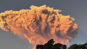
November, the column of gas and ash reached a maximum height of 1,300 m measured from the summit of the volcano, and on November 27 it dispersed up to 1,700 m above the volcano. The direction of dispersion of the column maintained a tendency mainly towards the West-South-West to South-West flank of the volcano, with the possibility of weak ash falls in the villages located in this direction relative to the crater.
Source et photo : SGC
Japan , Suwanosejima :
JMA reported that the eruption at Suwanosejima’s Ontake Crater continued during 20-27 November and crater incandescence was visible nightly. No explosions were detected, though ash plumes rose as high as 1.2 km above the crater rim and drifted mainly SE and W during 20-21 and 25 November. The Alert Level remained at 2 (on a 5-level scale) and the public was warned to stay at least 1 km away from the crater.
The 8-km-long island of Suwanosejima in the northern Ryukyu Islands consists of an andesitic stratovolcano with two historically active summit craters. The summit is truncated by a large breached crater extending to the sea on the east flank that was formed by edifice collapse. One of Japan’s most frequently active volcanoes, it was in a state of intermittent Strombolian activity from Otake, the NE summit crater, between 1949 and 1996, after which periods of inactivity lengthened. The largest recorded eruption took place in 1813-14, when thick scoria deposits blanketed residential areas, and the SW crater produced two lava flows that reached the western coast. At the end of the eruption the summit of Otake collapsed, forming a large debris avalanche and creating the open Sakuchi caldera, which extends to the eastern coast. The island remained uninhabited for about 70 years after the 1813-1814 eruption. Lava flows reached the eastern coast of the island in 1884. Only about 50 people live on the island.
Source : Agence météorologique japonaise (JMA) , GVP.
Photo : Ontake , Masanori Genko
Alaska , Shishaldin :
54°45’19 » N 163°58’16 » W,
Summit Elevation 9373 ft (2857 m)
Current Volcano Alert Level: WATCH
Current Aviation Color Code: ORANGE
Activity continues at Shishaldin Volcano. Seismic activity remains elevated with small, low-frequency earthquakes observed during the past day. Possible small explosions were also observed in infrasound data. Clear satellite and webcam imagery showed weakly elevated surface temperatures and a persistent steam and gas plume from the summit and collapse scarps on the volcano’s upper flanks. Passing aircraft reported the steam plume altitude at 10,000 to 11,000 ft, but there were no signifcant ash emissions detected in association with this activity.
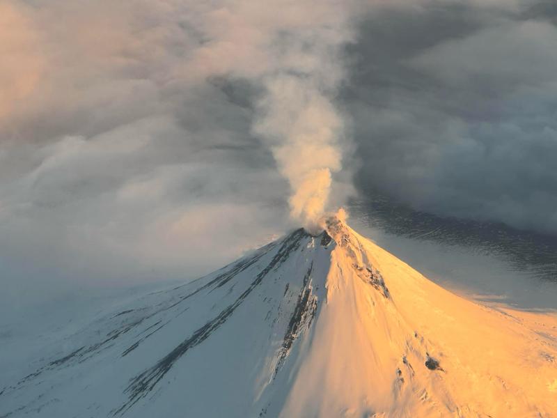
Thirteen significant explosive events have occurred at Shishaldin since July 12 through October 3, 2023. These events have been preceded by increases in seismicity in the hours to days before they occur. It is unknown how long this period of ongoing activity will last. However, previous eruptions of Shishaldin Volcano have lasted weeks to months with repeated cycles of eruptive activity like those seen since July.
Local seismic and infrasound sensors, web cameras, and a geodetic network monitor Shishaldin Volcano. In addition to the local monitoring network, AVO uses nearby geophysical networks, regional infrasound and lighting data, and satellite images to detect eruptions.
Source : AVO.
Photo : Reedy, Brian
Indonesia , Dukono :
An eruption of Mount Dukono occurred on Friday, December 1, 2023, at 07:40 WIT. The height of the eruptive column was observed to be ±2,000 m above the peak (±3,087 m above sea level). The ash column was observed to be white to gray in color with thick intensity, oriented towards the West. The eruption was recorded on a seismograph with a maximum amplitude of 10 mm and a duration of 174.89 seconds.
VOLCANO OBSERVATORY NOTICE FOR AVIATION – VONA
Issued : November 30 , 2023
Volcano : Dukono (268010)
Current Aviation Colour Code : ORANGE
Previous Aviation Colour Code : orange
Source : Dukono Volcano Observatory
Notice Number : 2023DUK032
Volcano Location : N 01 deg 41 min 35 sec E 127 deg 53 min 38 sec
Area : North Maluku, Indonesia
Summit Elevation : 3933 FT (1229 M)
Volcanic Activity Summary :
Eruption with volcanic ash cloud at 22h40 UTC (07h40 local).
Volcanic Cloud Height :
Best estimate of ash-cloud top is around 10333 FT (3229 M) above sea level or 6400 FT (2000 M) above summit. May be higher than what can be observed clearly. Source of height data: ground observer.
Other Volcanic Cloud Information :
Ash cloud moving to west. Volcanic ash is observed to be white to gray. The intensity of volcanic ash is observed to be thick.
Remarks :
Eruption recorded on seismogram with maximum amplitude 10 mm and maximum duration 174.89 second.
Source et photo : Magma Indonésie.