November 23 , 2023.
Italy / Sicily , Etna :
WEEKLY BULLETIN, November 13, 2023 to November 19, 2023. (issue date November 21, 2023)
SUMMARY STATEMENT OF ACTIVITY
In light of the monitoring data, it appears:
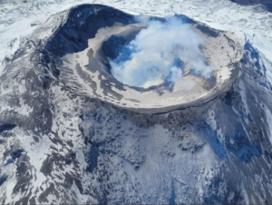
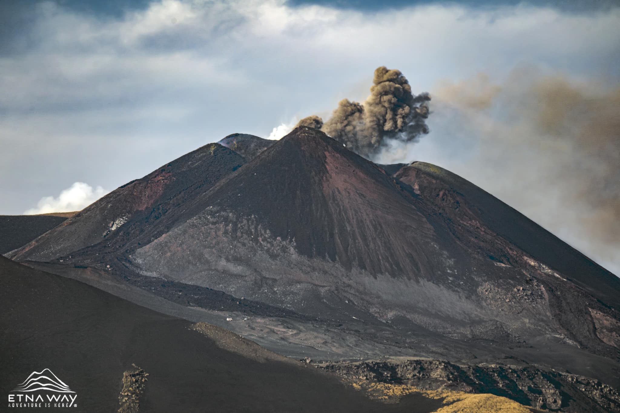
1) VOLCANOLOGICAL OBSERVATIONS: Degassing activity at Bocca Nuova (BN). Strombolian activity in the period before and after the lava fountain event on November 12 and eruptive activity at the Southeast Crater (SEC). The Voragine crater (VOR) continues to be blocked with low fumarolic activity. The Northeast Crater (NEC) continues to be obstructed with weak fumarolic activity along the internal walls.
2) SEISMOLOGY: Very low seismic activity due to fracturing. Concerning the average amplitude of the volcanic tremor, it almost always remained within the range of average values. It was only in a few brief moments (between November 10 and 12) that the amplitude reached high values, with maximum values recorded on November 12 during the Southeast Crater lava fountain.
3) INFRASOUND: Lack of reliability in detecting infrasound events due to strong wind. Very energetic infrasound activity at the Southeast Crater from November 12.
4) GROUND DEFORMATIONS: Since the date of the last monthly bulletin, the ground deformation monitoring networks have recorded significant variations during the lava fountain event of November 12.
5) GEOCHEMISTRY: SO2 flux at medium level
CO2 fluxes from the ground are at medium-low values.
The partial pressure of CO2 dissolved in groundwater presents values included in seasonal variability.
The helium isotope ratio in peripheral sites is average.
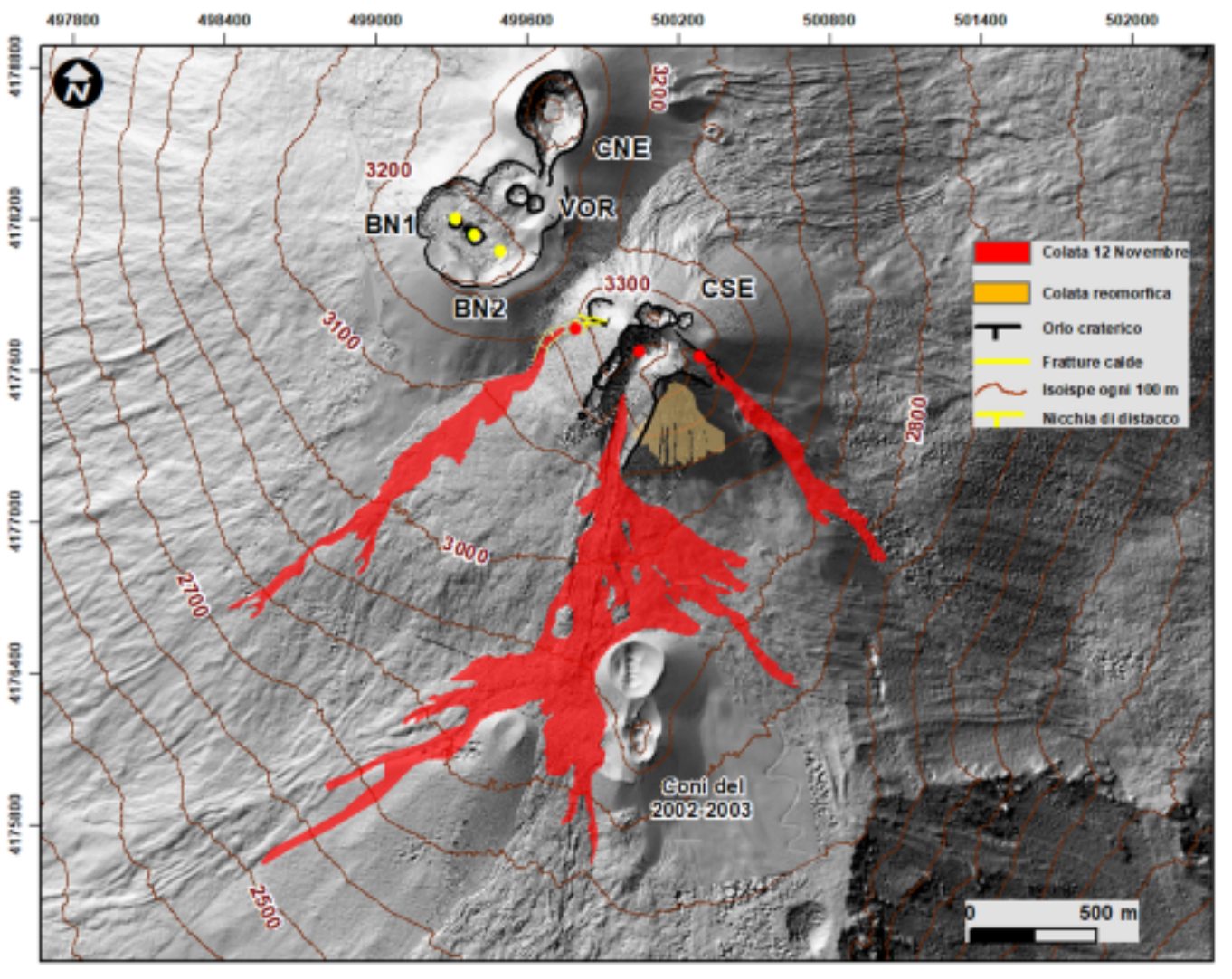
Map of the summit craters and the flow on a shaded model of the terrain of the summit craters of Etna (30 cm resolution) obtained by processing drone images acquired during several flybys (June, July and September 2023), superimposed on the model shaded from the Pléiades images of August 22, 2020 (AO and detection). CSE = Southeast Crater, CNE = Northeast Crater, BN = Bocca Nuova, VOR = Voragine. Updated as of September 3, 2023.
6) SATELLITE OBSERVATIONS: Thermal activity observed by satellite after the lava fountain on November 12, 2023 was generally low level with rare and isolated anomalies of moderate level.
7) OTHER OBSERVATIONS: The composition of the volcanic glass emitted during the lava fountain of November 12, 2023 suggests a magma with a composition comparable to that
of the previous paroxysm of August 2023. Overall, the magma emitted does not reach the degree of primitiveness of the magma emitted during the paroxysms of February 2022.
PLEASE NOTE: The data contained in this weekly bulletin refers, exceptionally, to the time interval from November 1 to 19, 2023,
VOLCANOLOGICAL OBSERVATIONS
The monitoring of the volcanic activity of Etna, during the period in question, was carried out through various inspections in the summit area and through the analysis of images from the surveillance cameras of the INGV, Osservatorio Etneo (INGV -OE).
Observations at the Southeast Crater (SEC)
Strombolian activity resumes on October 22 and becomes more continuous and slightly increases until November 4 when we observe an increase in the frequency of explosions (approximately every 3 minutes) and the formation of a small cone of waste around the mouth of the saddle.
On November 10, near the niche under the « mouth of the saddle », we observed the formation of two lava flows which reached approximately 10 m in length and exhausted themselves after a few hours.
Strombolian activity underwent a further increase until the evening of November 11 when around midnight a sharp decrease was noted.
On November 12, Strombolian activity resumed, intensifying and producing a small lava overflow at 9:00 UTC. Strombolian activity during the afternoon increases rapidly, turning into a lava fountain around 16:30 UTC. Due to cloud cover, it was not possible to observe the development phases of the event in detail. In the rare intervals of visibility it was possible to highlight that there were two main explosive vents and that they were producing an eruptive column at 4,500 m altitude, causing fallout of ash and lapilli from Milo to Zafferana and from Torre Archirafi to Pozzillo.
From 7:40 p.m. UTC, several pyroclastic flows formed which extended on the west side of the Valle del Bove in a south-southeast direction.
Around 20:00 UTC the paroxysm ends and gives way to weak and discontinuous Strombolian activity.
This eruptive activity continued with the establishment of several lava flows in different directions South, South-East, South-South-West and South-West.
The flows were mapped using SWIR Sentinel 2 images from the 13th and Skysat images from the 14th. The thicknesses were estimated from ground observations, and the surface and emitted volumes are respectively 0.8×10^6 m2 and 3×10^6 m3, the error on the surface is approximately 30% and that on the volume is 40%.
In the days that followed and until today, Strombolian activity has been present but discontinuous both in frequency and intensity.
Concerning the other summit craters, the activity was mainly degassing by the Bocca Nuova and of the fumarolic type with regard to the North-East crater and the Voragine which seem obstructed.
Photos : INGV , Etnaway.
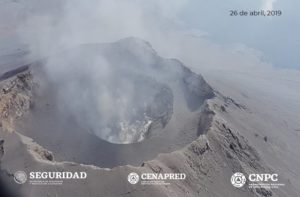
Philippines , Kanlaon :
KANLAON VOLCANO ADVISORY , 22 November 2023 ,8:30 A.M.
This is a notice of increased seismic activity at Kanlaon Volcano.
A total of fifteen (15) volcano-tectonic or VT earthquakes have been recorded by the Kanlaon Volcano Network between 3:58 AM and 5:00 AM, 22 November 2023. These earthquakes ranged in energy from ML1.4 to ML4.2 and occurred at depths of 0 to 2 kilometers beneath the northern flank of the Kanlaon range. Volcanic sulfur dioxide (SO2) gas emission from the summit crater has been elevated since 1 May 2023, averaging 570 tonnes/day since then, with the latest SO2 measurement on 14 November 2023 averaging 1,017 tonnes/day. Ground deformation data from continuous GPS and electronic tilt measurements have been recording shorter-term inflation of the southwestern middle slopes since October 2023 and longer-term inflation of the entire edifice since March 2022. While monitoring parameters in the past months have been consistent with shallow hydrothermal activity driven by degassing of deeper magma, ongoing VT earthquake activity indicates shallow rock-fracturing on the edifice which may lead to further unrest.

The public is reminded that Alert Level 1 prevails over Kanlaon. Should the above uptrend in monitoring parameters persist, the volcano status may be raised to Alert Level 2 to warn of increasing unrest. The public and local government units are strongly advised to be vigilant and refrain from entering the four (4) kilometer Permanent Danger Zone (PDZ) due to increased chances of sudden and hazardous phreatic eruptions occurring without warning. Civil aviation authorities must also advise pilots to avoid flying close to the volcano’s summit as ejecta from any sudden phreatic eruption can be hazardous to aircraft.
DOST-PHIVOLCS is closely monitoring Kanlaon Volcano’s activity and any new development will be relayed to all concerned.
Source et photo : Phivolcs
Iceland , Rekjanes Peninsula :
Small movements are measured within the dyke in and around Grindavík
Strong evidence for a link between magma accumulation at Svartsengi and magma tunnel formation. It is very likely that magma will emerge in the area between Hagafell and Sýlingarfell. Updated November 22 at 6:15 p.m.
Around 300 earthquakes were recorded yesterday and 100 earthquakes were recorded since midnight, far fewer than in recent days. There has also been a reduction in earthquakes greater than magnitude 2.0. At the end of the day, weather and precipitation continue to affect the sensitivity of the system to detect smaller earthquakes.
Deformation and inflow associated with magma tunneling continue to decrease. he uprising in Svartsengi continues at a similar pace. Model calculations, based on data from November 21, indicate that the inflow into the magma tunnel is greatest at Sundhnúksgíga, about 4 km north-northeast of Grindavík. Small movements have been detected within the dyke in and around Grindavík in recent days.
There is still a possibility of an eruption in the area above the magma tunnel. It is very likely that magma will emerge in the area between Hagafell and Sýlingarfell. As seismic activity and inflow into the magma tunnel continues to decrease, the likelihood of an eruption decreases over time.
Based on the latest data and taking into account the development of activity since November 10, the probability of a sudden eruption within the city limits of Grindavík decreases every day and is today considered low. It can be assumed that the magma in the tunnel under Grindavík is partially solidified, which also reduces the likelihood of the magma suddenly rising to the surface within the city limits. However, it should be noted that there is still a possibility of a volcanic eruption above the magma tunnel and the most likely area for the source of an eruption is between Hagafell and Sýlingarfell.
Importantly, there is strong evidence for a link between magma accumulation at Svartsengi and the formation of the magma tunnel on November 10. Models indicate that magma from the intrusion that formed the dyke beneath Svartsengi traveled east to Sundhnúksgígir and subsequently formed the magma corridor with the large upheavals that then occurred. As movements at Svartsengi continue, it can be expected that the magma accumulating there may flow again. In doing so, it could flow into the magma tunnel that now lies beneath Grindavík. A new magma passage can also be expected to form, e.g. west of Svartsengi. Premonitions of such a scenario could be detected on seismic and GPS monitors.
Source : IMO.
Photo : mbl.is/Eggert Jóhannesson
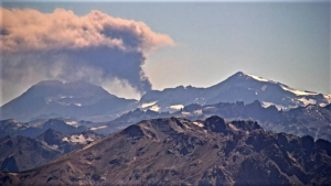
Colombia , Chiles / Cerro Negro :
Weekly activity bulletin from the Chiles Volcanic Complex / Cerro Negro (CVCCN).
Regarding the monitoring of the activity of the CHILES AND CERRO NEGRO VOLCANOES, the MINISTRY OF MINES AND ENERGY, through the COLOMBIAN GEOLOGICAL SERVICE (SGC), reports that:
For the period from November 14 to 20, 2023, and compared to the previous week, seismic activity presented a significant increase both in terms of occurrence and energy released.
The peak of occurrence was recorded on November 20 with a total of 1,624 earthquakes. The predominance of earthquakes associated with the fracturing of rocks inside the volcanic edifice remains, followed by seismicity linked to the movement of fluids.
The fracturing earthquakes occurred mainly to the south of Chiles Volcano, at distances up to 4 km, with depths less than 7 km from its summit (4,700 m a.s.l.). The maximum recorded magnitude was 3.1. No felt earthquakes were reported.
Deformation processes continue in several sectors of the CVCCN.
Due to internal processes derived from a complex interaction between the magmatic, hydrothermal system and geological faults in the area, the evolution of activity in the CVCCN continues. This is why the probability of the occurrence of energetic earthquakes persists which can be felt by the inhabitants of its zone of influence.
Volcanic activity remains on YELLOW ALERT, Status: Active volcano with changes in the behavior of the base level of monitored parameters and other manifestations
Source et photo : SGC
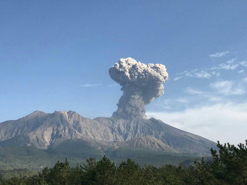
Japan , Sakurajima :
JMA reported ongoing activity at Minamidake Crater (Aira Caldera’s Sakurajima volcano) during 13-20 November, with incandescence at the crater observed nightly. An explosion at 20h53 on 13 November produced an ash plume that rose 400 m above the crater rim. Sulfur dioxide emissions were very high, averaging 3,000 tons per day on 13 November. An explosion at 06h29 on 17 November generated an ash plume that rose as high as 1.1 km above the crater rim and drifted SE to SW and ejected large blocks 500-700 m from the crater. The Alert Level remained at 3 (on a 5-level scale), and the public was warned to stay 2 km away from both craters.
The Aira caldera in the northern half of Kagoshima Bay contains the post-caldera Sakurajima volcano, one of Japan’s most active. Eruption of the voluminous Ito pyroclastic flow accompanied formation of the 17 x 23 km caldera about 22,000 years ago. The smaller Wakamiko caldera was formed during the early Holocene in the NE corner of the caldera, along with several post-caldera cones. The construction of Sakurajima began about 13,000 years ago on the southern rim and built an island that was joined to the Osumi Peninsula during the major explosive and effusive eruption of 1914. Activity at the Kitadake summit cone ended about 4,850 years ago, after which eruptions took place at Minamidake. Frequent eruptions since the 8th century have deposited ash on the city of Kagoshima, located across Kagoshima Bay only 8 km from the summit. The largest recorded eruption took place during 1471-76.
Sources : Agence météorologique japonaise (JMA) , GVP.
Photo : Rizal M.