November 11 2023 .
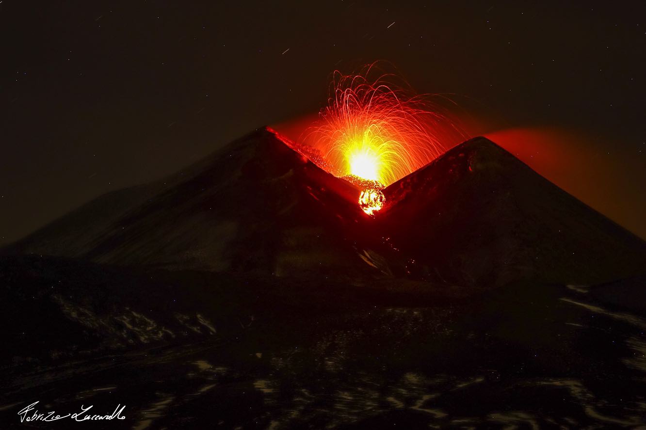
Italy / Sicily , Etna :
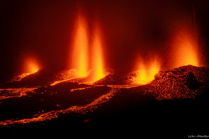
Strombolian activity in progress with a small flow from the South-East Crater.
VOLCANO OBSERVATORY NOTICE FOR AVIATION (VONA)
Issued: November 09 ,2023
Volcano: Etna
Current Color Code: ORANGE
Previous Color Code: yellow
Source: Etna Volcano Observatory
Notice Number: 2023/0076/11N01
Volcano Location: 3744N 01500E
Area: Italy
Summit Elevation: 3300 m
Volcanic Activity Summary:
MODERATE EXPLOSIVE ACTIVITY AT THE SUMMIT CRATERS. NO ASH EMISSION
Volcanic cloud height: NO ASH CLOUD IS PRODUCED
Other volcanic cloud information: N/A
Remarks:
THE PHENOMENON IS OBSERVED BY VISIBLE AND THERMAL SURVEILLANCE CAMERAS
Waiting for the official press release from the INGV
Source : LCDV
Photo : Fabrizio Zuccarello
Iceland , Reykjanes Peninsula :
Magnitude 4.1 earthquake east of Sýlingarfell . Ongoing seismic activity on the Reykjanes Peninsula. Around 800 earthquakes have been recorded since midnight . Updated 10. November at 2pm
Earlier today, at 12:44, an earthquake of magnitude 4.1 occurred near Sýlingarfell, west of Sundhnjúkagígar. The craters are about 2-3 km northeast of Grindavík. A dense swarm of earthquakes began around 07:00 this morning in the same area, and nearly 800 quakes have been recorded since midnight, including 9 greater than magnitude 3. The depth of the earthquakes is about 5 km. Such earthquake swarms have previously been recorded in this area. It cannot be ruled out that the seismic activity near Sundhnjúkagígar is due to magma movements at depth.
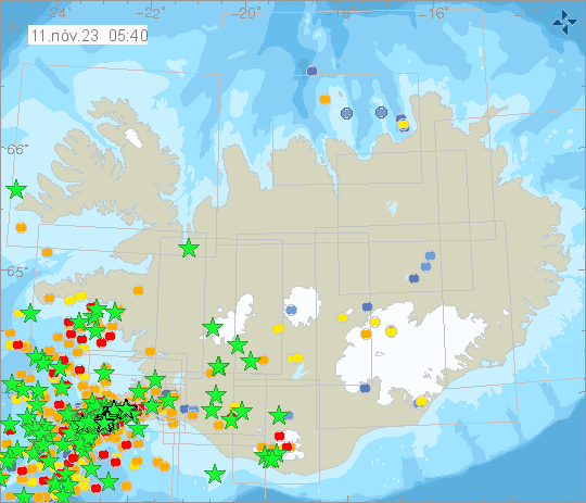
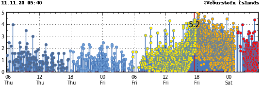
Magma accumulation continues near Þorbjörn at the same depth and at a similar rate as before. It is accompanied by swarm-like seismic activity, as was noticed yesterday and this morning. While magma accumulation continues, ongoing seismic activity can be expected due to stress release in the area. Earthquakes up to magnitude M5.5 can be expected in such swarms, and the seismic activity may shift between areas. At this stage, there are no indications that magma is forcing its way to the surface
Magma intrusion possibly extending beneath Grindavík . Civil Protection authorities declare emergency Level. Residents of Grindavík are advised to proceed with caution. Updated 10. November at 11:30pm
Significant changes have occurred in the seismic activity measured near Sundhnjúkagígar north of Grindavík and deformation observed in the Reykjanes Peninsula this afternoon. The seismic activity has moved south towards Grindavík. Based on how the seismic activity has evolved since 6 PM today, along with results from GPS measurements, there is a likelihood that a magma intrusion has extended beneath Grindavík. In light of this outcome, the police chief in Suðurnes, in cooperation with the Civil Protection Authorities, has decided to evacuate Grindavík. An emergency level of civil protection is now in effect. This is not an emergency evacuation. Residents of Grindavík are advised to proceed with caution.
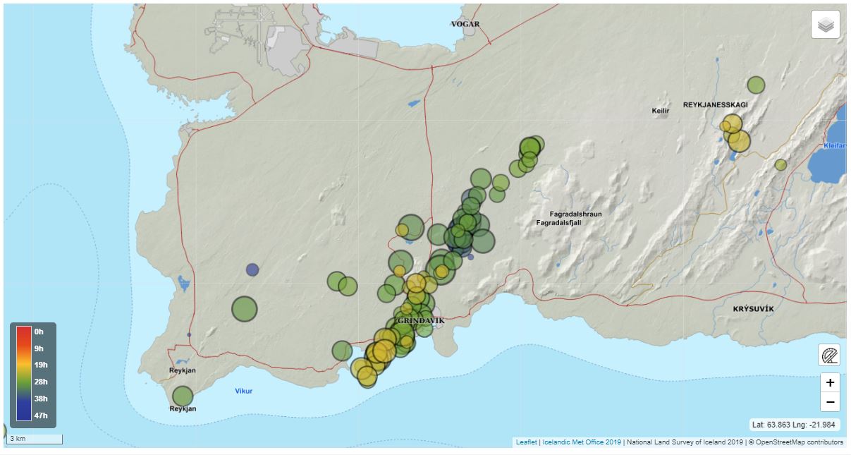
At this stage, it is not possible to determine exactly whether and where magma might reach the surface. There are indications that a considerable amount of magma is moving in an area extending from Sundhnjúkagígum in the north towards Grindavík. The amount of magma involved is significantly more than what was observed in the largest magma intrusions associated with the eruptions at Fagradalsfjall. Further data is being collected to calculate models that provide a more accurate picture of the magma intrusion. It is currently not possible to say when this work will be completed.
Newest information from GPS and satellite images confirm a dike from Sundhnjúkagig through Grindavík and to the Southwest. The Civil Defence have declared a state of emergency.
Ongoing intense seismic swarm at Sundhnjúkagígar craters, north of Grindavík ,with increasing activity since 15:00 yesterday.The largest earthquake in the swarm occurred at 18:00 and is estimated M5.0 and occurred 1 km East of Mt. Þorbjörn. Earthquakes larger than previously recorded in this event might occur and the activity might lead to an eruption. The aviation color code has been updated to orange. The Icelandic Meteorological Office is closely monitoring the activity and its progress. The last 24 hours around 3000 earthquakes have beeen detected. 11 earthquakes larger than M4 have been detected, there of one M5.
Source : IMO.
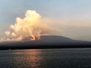
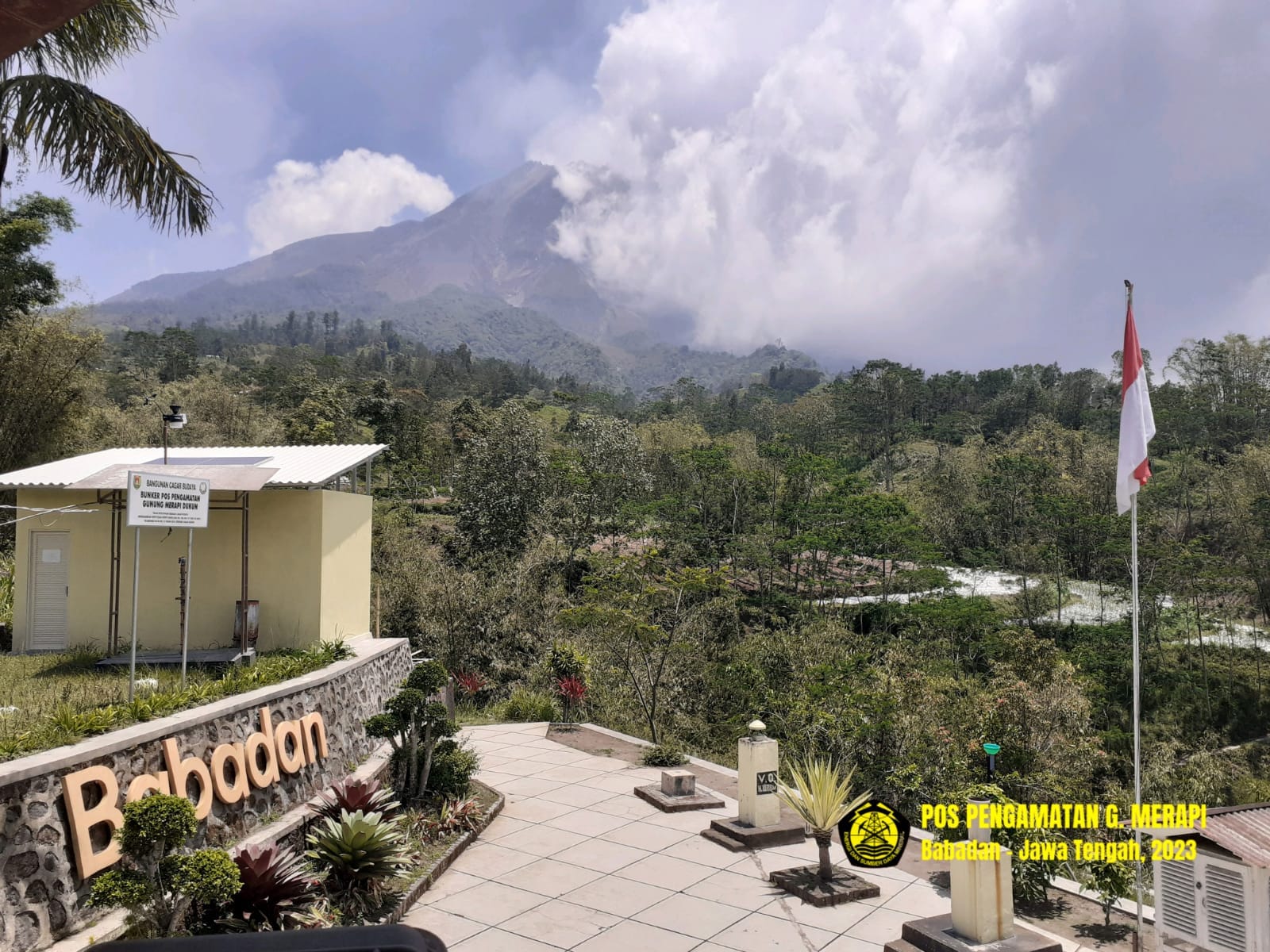
Indonesia , Merapi :
Report on the activity of Mount Merapi from November 3, 2023 to November 9, Published on November 10, 2023.
OBSERVATION RESULTS
Visual
The weather around Mount Merapi is generally sunny in the morning and afternoon, while the evening is foggy. White smoke, fine to thick, low to medium pressure and 250 m high was observed from the observation post of Mount Merapi in Badaban on November 4, 2023 at 5:30 a.m.
This week, lava avalanches were observed 79 times towards the South and South-West, including 4 times upstream of the Boyong River up to 1500 m, 74 times upstream of the Bebeng River up to a maximum of 2000 m and 1 time upstream of the Sat / Putih river up to a maximum of 1500 m. The sound of avalanches was heard 13 times from the Babadan post with low to moderate intensity.
Based on the analysis of aerial photos from September 28, 2023, the volume of the southwest dome was measured at 3,097,700 cubic meters and that of the central dome at 2,358,500 cubic meters.
Seismicity
This week, the seismicity of Mount Merapi showed:
3 shallow volcanic earthquakes (VTB)
1 low frequency earthquakes (LF)
1787 multi-phase (MP) earthquakes,
784 avalanche earthquakes (RF)
9 tectonic earthquakes (TT).
The intensity of seismicity this week is lower than last week, but the number of earthquakes is still quite high.
Deformation
The deformation of Mount Merapi that was monitored using EDM this week showed a shortening of steepening distance of 0.02 cm/day.
Rain and lahars:
There was rain this week at Mount Merapi Badaban observation post with an intensity of 36 mm/hour for 20 mins on November 7, 2023. There were no reports of additional flows or lahars from of rivers that descend from Mount Merapi.
Conclusion
Based on the results of visual and instrumental observations, it is concluded that:
-Mount Merapi’s volcanic activity is still quite high in the form of effusive eruption activity. The activity status is defined at the “SIAGA” level.
The current danger potential is in the form of lava avalanches and hot clouds in the South-South-West sector including the Boyong river for a maximum of 5 km, the Bedog, Krasak, Bebeng rivers for a maximum of 7 km. In the South-East sector, it includes the Woro river for a maximum of 3 km and the Gendol river for 5 km. While the ejection of volcanic material in the event of an explosive eruption can reach a radius of 3 km from the summit.
Source : BPPTKG
Photo : BPPTKG
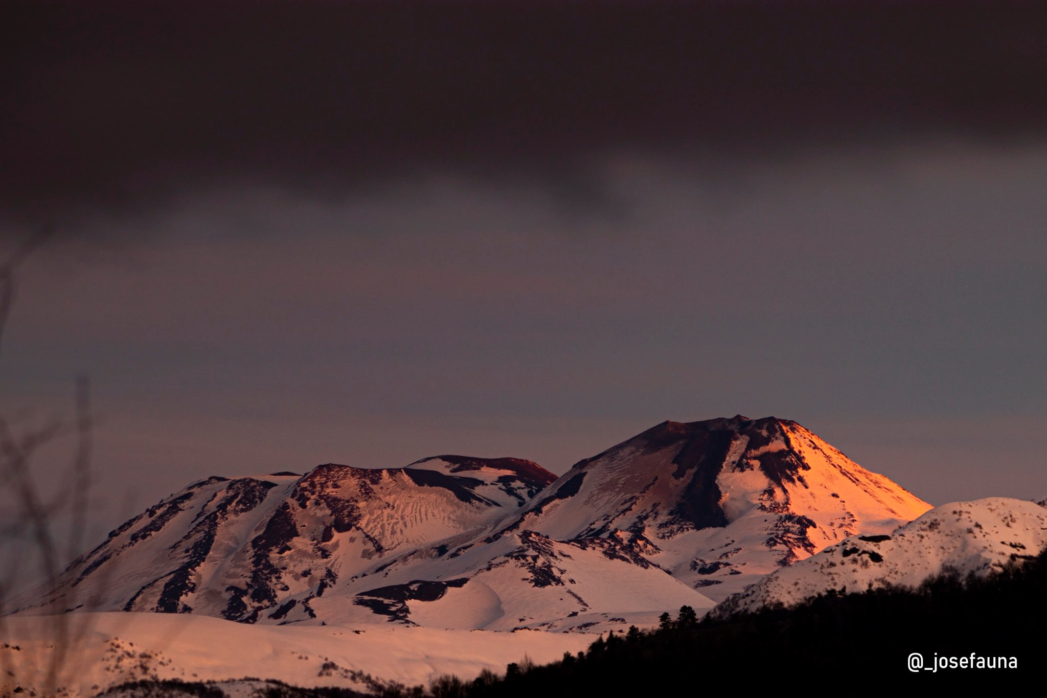
Chile , Nevados de Chillan :
Seismology
The seismological activity of the period was characterized by the recording of:
132 seismic events of type VT, associated with the fracturing of rocks (Volcano-Tectonics). The most energetic earthquake had a Local Magnitude (ML) value equal to 1.7, located 4.0 km east-southeast of the volcanic edifice, at a depth of 3.4 km relative to to the crater.
4 LP type seismic events, associated with fluid dynamics inside the volcanic system (Long Period). The size of the largest earthquake evaluated from the Reduced Displacement (RD) parameter was equal to 2 cm2.
1 VLP (Very Long Period) type seismic event, associated with the dynamics of large volumes of fluids within the volcanic system. The size of the earthquake evaluated from the Reduced Displacement (RD) parameter was equal to 4 cm2.
Fluid geochemistry
The sulfur dioxide (SO2) emissions data obtained by the differential optical absorption spectroscopy (DOAS) equipment, corresponding to the Chillán station, installed 1.5 km in the South-South-East (SSE) direction ) of the active crater, presented an average SO2 flux value of 380 ± 131 t/d, with a maximum of 500 t/d on October 7.
Satellite thermal anomalies
No thermal anomalies have been reported according to mid-infrared observation of volcanic activity (MIROVA, http://www.mirovaweb.it/). Additionally, no radiation anomalies were reported, according to analytical processing of Sentinel 2-L2A satellite images in combination of false color bands.
Geodesy
From the data provided by 4 continuous GNSS stations, installed on the volcanic edifice and which make it possible to monitor its deformation, we observe that the deflationary trend previously reported is maintained, with maximum rates of 0.4 cm/month. Horizontal displacements also show stable and small trends, with maximum rates of 0.2 cm/month.
Surveillance cameras
Images provided by the fixed camera, installed near the volcanic complex, recorded passive degassing, with a maximum height reaching 320 m above the crater level on October 12.
Activity remained at levels considered low, suggesting stability of the volcanic system. The volcanic technical alert is maintained at: GREEN TECHNICAL ALERT: Active volcano with stable behavior – There is no immediate risk
Source : Sernageomin
Photo : josefauna . ( archive)
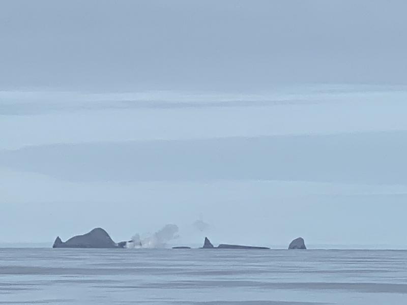
Alaska , Bogoslof :
53°55’38 » N 168°2’4″ W,
Summit Elevation 492 ft (150 m)
Current Volcano Alert Level: ADVISORY
Current Aviation Color Code: YELLOW
Only one magnitude 2 earthquake was located near Bogoslof volcano in the last week after a more significant swarm of earthquakes that started around October 22. There have been no other signs of unrest observed in satellite or other data over the past week.
Bogoslof volcano is monitored using a single local seismic station, distant seismic and infrasound instruments, satellite data, and lightning networks.
At least nine historical eruptions have been documented at Bogoslof volcano. The most recent occurred from December 2016 to August 2017 and produced seventy main explosive events that generated volcanic ash clouds that rose as high as 42,500 ft (13 km) above sea level, and greatly modified the topography of Bogoslof Island. Previous eruptions of the volcano have lasted weeks to months and have on occasion produced ash fall on the community of Unalaska. Eruptions of the volcano are often characterized by multiple explosive ash-producing events as well as the growth of lava domes.
Bogoslof Island is the largest of a cluster of small, low-lying islands making up the summit of a large submarine stratovolcano. The highest point above sea level is about 490 ft (150 m); however, the volcano is frequently altered by both eruptions and wave erosion and has undergone dramatic changes in historical time. The two main islands currently above sea level are Fire Island and Bogoslof Island, both located about 61 miles (98 km) northwest of Unalaska/Dutch Harbor, 76 miles (123 km) northeast of Nikolski, and 93 miles (149 km) northeast of Akutan. The volcano is situated slightly north (behind) the main Aleutian volcanic front.
Source : AVO
Photo : Shaishnikoff, Trever ,