October 23 , 2023.
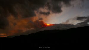
Philippines , Bulusan :
NOTICE OF ACTIVITY OF BULUSAN VOLCANO, October 22, 2023, 9:00 p.m.
This is an advisory of seismic activity on Bulusan Volcano.
A total of eighty-seven (87) volcanic earthquakes were recorded by the Bulusan Volcano (BVN) Sensor Network since 5 a.m. on October 21, 2023. Among them, twenty-nine (29) were earthquakes. volcano-tectonic earthquakes or VTs associated with rock fracturing processes occurring 1 to 8 kilometers below the South and West sectors of the Bulusan volcano. Degassing at the active summit crater and vents was low to moderate this week, while SO2 volcanic gas emissions on October 19, 2023 were on average close to background values, i.e. 241 tonnes/day. Ground deformation data from electronic tilt monitoring indicate continued inflation of the general southern flank since February 2023. A notable increase in volcanic carbon dioxide (CO2) concentrations from June to August 2023 and in temperature since February was detected in a monitored source in the Southwest sector of the building. The above parameters indicate that hydrothermal activity caused by deep magma degassing could occur beneath the volcano and lead to steam-driven eruptions at one of the summit vents.
Alert Level 0 (Normal) is maintained at Bulusan Volcano, but there are increased risks of phreatic or steam-induced eruptions occurring at the crater or summit area. Local authorities and the public are, however, reminded that entry into the permanent danger zone (PDZ) with a radius of 4 kilometers, particularly near vents on the South-South-East slopes, should be avoided by due to the possibility of sudden and dangerous accidents caused by steam or phreatic eruption, rock falls and landslides. Civil aviation authorities should also advise pilots to avoid flying near the volcano’s summit, as ash from any sudden phreatic eruption can be dangerous for planes. Additionally, people living in valleys and along river and stream channels should be vigilant against sediment-laden river flows and lahars during heavy and prolonged rains.
DOST-PHIVOLCS is closely monitoring the status of Bulusan Volcano and any new developments will be relayed to all concerned.
Source : Phivolcs
Photo : Sorsogon news.
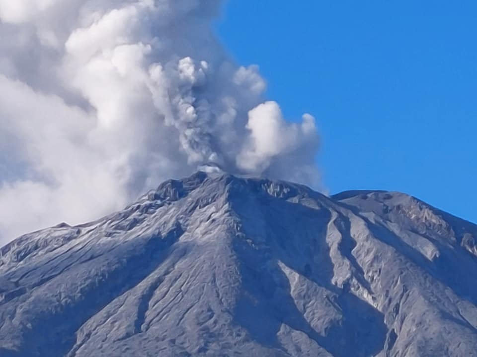
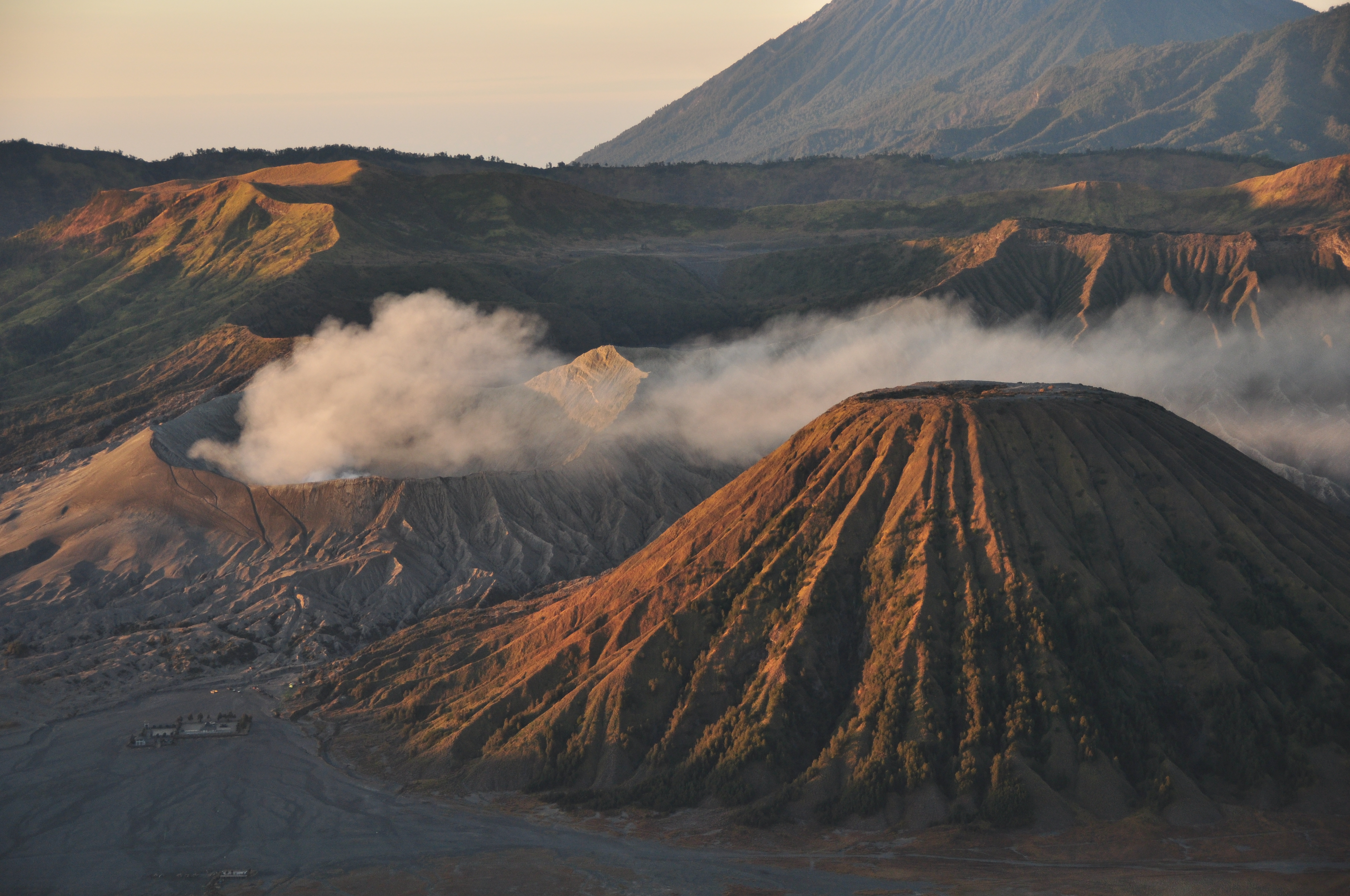
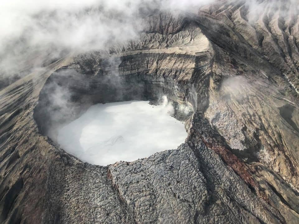
Indonesia , Bromo :
Press Release on the VOLCANIC ACTIVITY OF THE BROMO VOLCANO OCTOBER 23, 2023.
Mount Bromo (G. Bromo) is a cinder cone volcano located in the Tengger caldera with a height of 2,329 meters above sea level. The last eruption occurred in July 2019 in the form of an explosive eruption which was not preceded by a significant increase in seismicity.
The activity of the Mount Bromo crater is monitored visually and instrumentally from the Bromo Volcano Observation Post (PGA) located in the hamlet of Cemoro Lawang. The current activity level of Mount Bromo is Level II (WASPADA).
The latest developments on Mount Bromo activities until October 23, 2023 at 08:00 WIB are as follows:
Smoke from the crater was observed to be white, thin to thick, with a maximum height of 700 meters above the summit. The rumbling coming from inside the crater was subdued. Visual observations on the evening of October 21, 2023 showed that there was still incandescence coming from several locations at the bottom of the crater, observed since February 3, 2023. The color of the gas emitted from the crater indicated that currently the activity was dominated by the release of gas, no ash was carried to the surface.
Gas measurements at the crater rim with a gas detector on October 22, 2023 showed a maximum SO2 gas concentration of 4.3 ppm and a maximum H2S gas concentration of 1.7 ppm. The smell of sulfurous gas is moderate to strong at the crater rim. The concentration value of SO2 gas is relatively high and higher than the threshold value tolerable by humans, namely 2 ppm.
The current seismicity of Mount Bromo is still dominated by continuous tremors with a maximum amplitude of 1 mm, indicating a supply of fluid (gas, liquid) at shallower depths or associated with gas emission activity towards the surface .
Deformation measurements using a Tiltmeter show that the volcanic body has been inflating (inflation) since May 2023 by 40 microradians on the Tangential axis (perpendicular to the crater) and by 50 microradians on the Radial axis (directed towards the crater).
Satellite observations show the existence of thermal anomalies and an increase in the radiation temperature of Bromo crater since May 2023.
The potential danger that could arise due to the increased activity of the Mount Bromo crater is the appearance of phreatic or magmatic eruptions producing eruptive materials in the form of ash and thrown rocks whose distribution can reach a radius of 1 km from the center of the crater, as well as the potential dangers of volcanic gases which can have a negative impact on health.
Based on the results of the visual and instrumental assessments as well as the potential threat of danger, the activity level of Mount Bromo on October 23, 2023 at 08:00 WIB is assessed as always at Level II (WASPADA) with the following recommendations:
Communities around Mount Bromo and visitors/tourists/mountaineers should not enter the crater area within a radius of 1 km around the active crater of Mount Bromo, to avoid sudden phreatic eruptions without being preceded by clear volcanic symptoms, and to avoid the dangers of gas emissions.
Source : PVMBG.
Photo : G Vitton/ Le Chaudron de Vulcain.
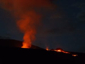
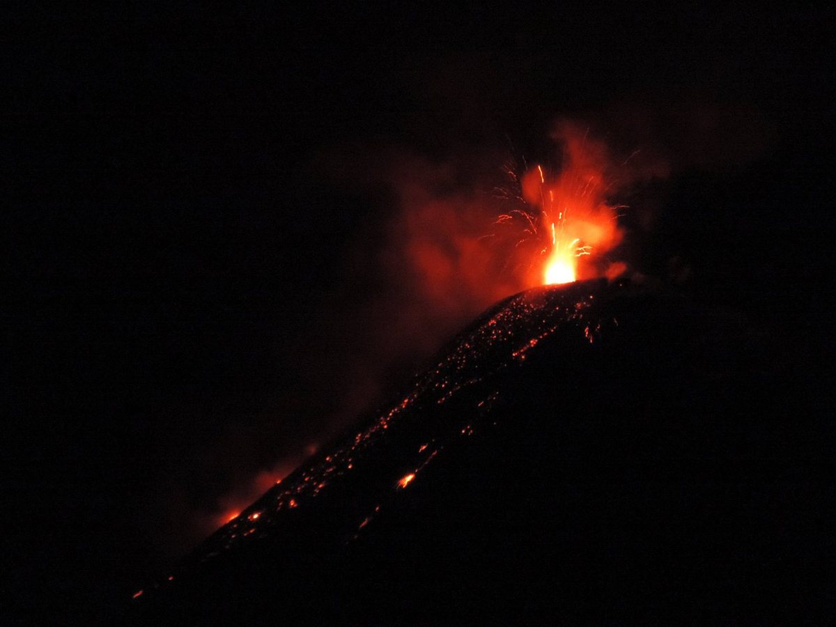
Ecuador , Reventador :
DAILY REPORT ON THE STATE OF REVENTADOR VOLCANO, Sunday October 22, 2023.
Information Geophysical Institute – EPN.
Surface activity level: High, Surface trend: No changes
Internal activity level: Moderate, Internal trend: No changes
Seismicity: From October 21, 2023, 11:00 a.m. to October 22, 2023, 11:00 a.m.:
The following table shows the number of seismic events from the reference station in the last 24 hours.
Explosion (EXP) 33
Long Period (LP) 13
Transmitting Tremor (TREMI) 5
Harmonic Tremor (TRARM) 4
Precipitation/Lahars:
Rainfall is not recorded. **In the event of heavy rains, these could remobilize the accumulated materials, generating mud and debris flows which would descend the sides of the volcano and flow into adjacent rivers.
Emissions/ash column:
Since yesterday afternoon, according to the network of surveillance cameras, several emissions of gas and ash have been observed with heights between 200 and 900 meters above the level of the crater, in the northeast direction. In addition, the Washington VAAC has published 3 reports of gas and ash emissions from a height of 705 m in the North, Northeast and Northwest directions.
Observation:
In the early hours of today, incandescence was observed at the crater level and a descent of incandescent material along the flanks of the volcano up to 900 meters below the level of the crater. At the moment the volcano is completely cloudy.
Alert level: Orange.
Source : IGEPN.
Photo : Hosteria
Mexico , Popocatepetl :
October 22, 11:00 a.m. (October 22, 5:00 p.m. GMT)
Activity from the last 24 hours
114 low-intensity exhalations were detected, accompanied by water vapor, volcanic gases and sometimes ash. Additionally, 843 minutes of very low to low amplitude, high frequency tremors were recorded.
The National Center for Communication and Operation of Civil Protection (Cenacom) reported light ash falls in the municipality of Amecameca (Delegation of San Pedro Nexapa) and Ozumba, State of Mexico, as well as in Tlaltizapán and Yecapixtla, Morelos.
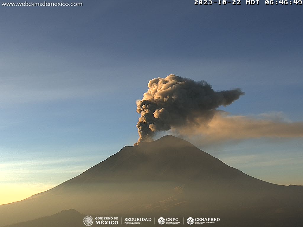
At the time of this report, a constant emission of water vapor, volcanic gases and ash in small quantities is observed in a South-South-West (SSW) direction.
The Popocatépetl volcanic warning fire is in yellow phase 2.
The scenarios planned for this phase are:
A few smaller to moderate explosions
Appearance of tremors of variable amplitude
Light to moderate ash rain in surrounding towns and some more distant towns
Ejection of incandescent fragments within the exclusion radius of 12 kilometers
Source et photo : Cenapred.
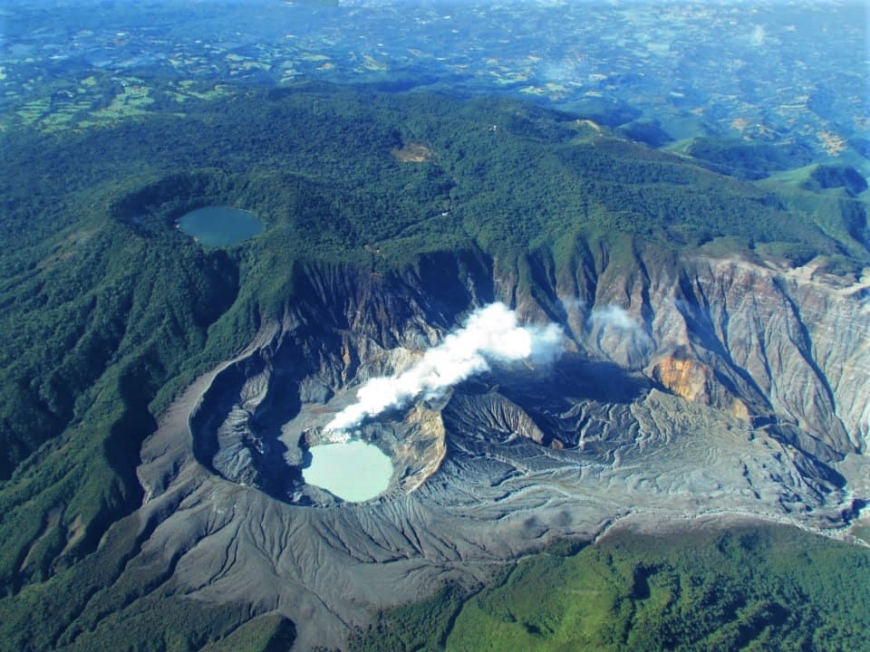
Costa Rica , Rincon de la Vieja / Poas / Turrialba :
Daily report on the state of volcanoes. OVSICORI-UNA, Date: October 22, 2023, Updated at: 7:00:00 p.m.
Rincón de la Vieja Volcano
Latitude: 10.83
Longitude:-85.324
Altitude: 1,916 meters
Activity observed:
Seismographs recorded several exhalations of water vapor and medium-energy gases. Seismographs continue to detect volcanic tremors which remain fairly constant, with high energy and a wide frequency spectrum between 0.6 and 6 Hz. A few short-lived spasmodic tremors are recorded, sometimes associated with the expiration of vapor from water, gas and aerosols. The fumaroles inside the West Crater are very active with almost constant emissions of water vapor and gas. Several VT volcano-tectonic earthquakes continue to be recorded within the volcanic edifice at depths of between 2 and 3 km below sea level. The volcanic edifice presents a slight uplift. The measured SO2 flow remains around 200 tonnes/day.
Environmental conditions:
The winds blow from the South-West and the summit remains mostly cloudy.
Activity Level: Caution (3)
Poas Volcano
Latitude: 10.2
Longitude: : -84 233
Altitude: 2,687 meters
Activity observed:
Seismographs do not record eruptions. The volcanic tremor remains quite stable with frequencies between 3 and 6 Hz, sometimes a weaker tremor is recorded with frequencies close to 10 Hz. SO2 fluxes remain less than 100 tonnes/day, with concentrations less than 1 part per million in the ambient air around the Visitor Viewpoint. The maximum CO2/SO2 gas ratio is 1.5 and the maximum SO2 concentration is 8.5, similar to previous days in the western sector of the active crater. Although the wind at the summit of Poás is moving towards the South-South-East, the instruments of the OVSICORI-UNA volcanic gas and aerosol monitoring station located in Coronado detect very low concentrations of SO2 gas (about 0.2 parts per million) and aerosols (PM10 maximum 18 ug/m3).
Environmental conditions:
The winds blow from the South-South-East and the summit remains mostly cloudy.
Activity Level: Warning (2)
Turrialba Volcano
Latitude: 10,025
Longitude: -83,767
Altitude: 3,325 meters

Activity observed:
Seismographs record no signs of volcanic eruptions or earthquakes. There are few volcanic tremors that can be recorded on seismographs and they are LP type and short tremors. Due to the wind direction towards the South-East, it is not possible to measure the concentrations of volcanic gases because the instruments are located to the North and West of the West Turrialba crater.
Environmental conditions:
The winds blow from the South-East and the summit remains generally cloudy.
Activity Level: Warning (2)
Source : Ovsicori.
Photos : Chris Allen , Raúl Mora/National Seismological Network , RSN.