July 22 , 2023.
Iceland , Litli Hrútur :
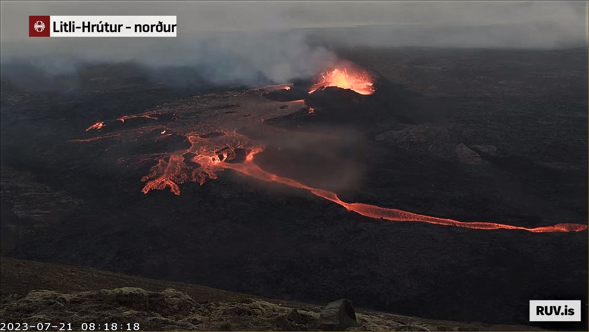
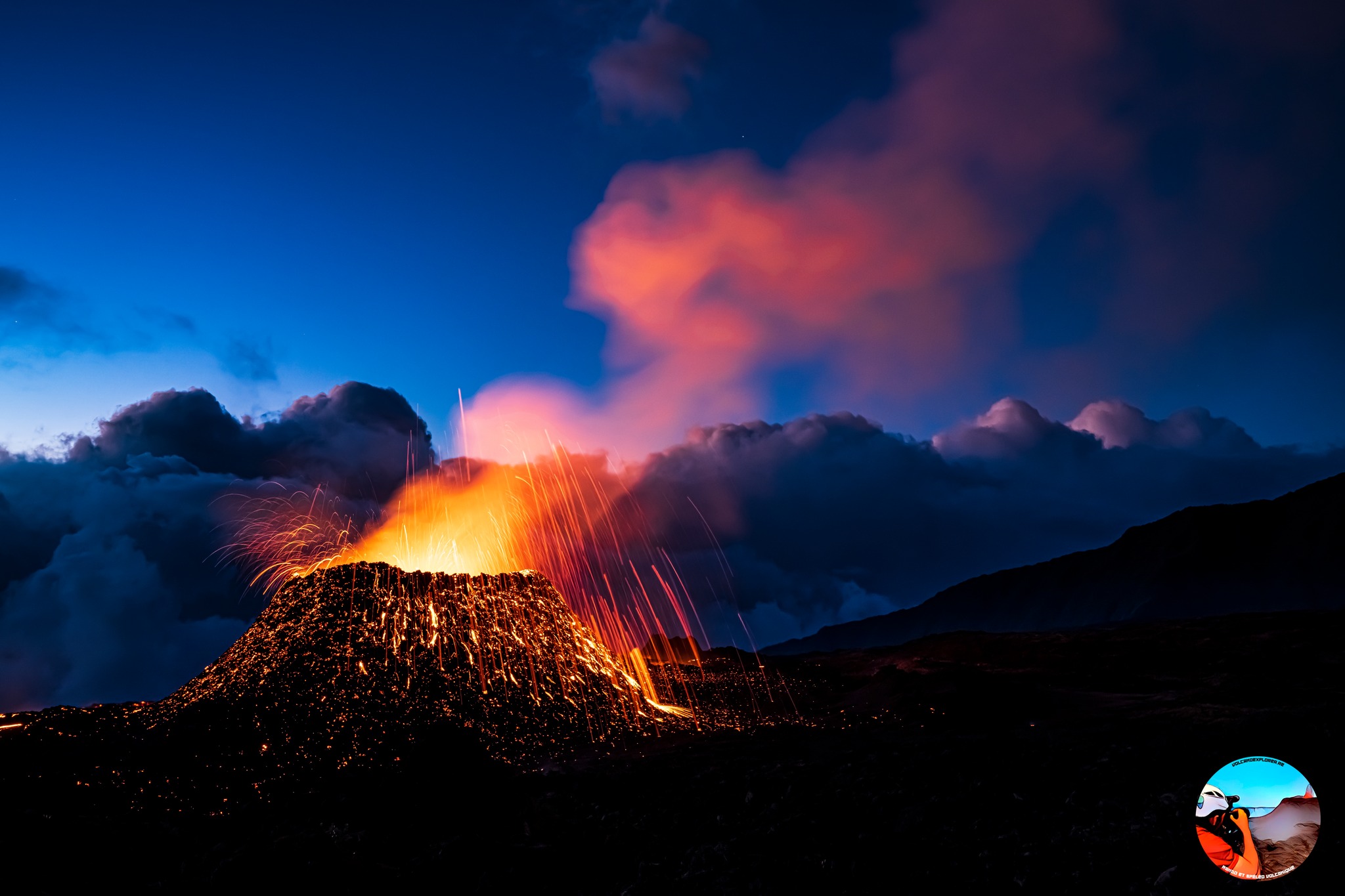
The attached image (time is given in the lower left corner) is from the crater area and is taken from the RUV stream of the eruption. It reveals a rather interesting evolution of the flow in the lava river. Over this time there is very little change in the activity at the vents or the lava pool to the west of the vent, yet the level of the lava river immediately south of the outlet from the lava pool dropped significantly during this period and I doing so formed beautiful lava falls. The darkening surface of the lava river also indicates that crust is developing and implies that the flow velocity in the river has also dropped. It appears that lava, which must have been accumulating somewhere lower down in this new lava flow, burst forward during this time period, and therefore the outflow from the lava pool cannot match the drainage from the lava river.
The University of Iceland’s Volcanology and Natural Hazards Laboratory reports that there is little to no change in activity within the crater or in the position of the lava pool to the west of the crater.
The surface of the lava river drops dramatically and beautiful lava waterfalls form right next to the flow of the lava pool. The surface of the crust is observed to darken over the flowing lava. He indicated that the speed of the flow in the lava river had decreased.
The magma, which accumulated below in the lava tube, is thought to have ruptured and therefore the flow of the lava pool is irrelevant.
Source : Rannsóknarstofa í eldfjallafræði og náttúruvá, Háskóli Íslands, Mbl.is
Photo : RUV
Alaska , Shishaldin :
54°45’19 » N 163°58’16 » W,
Summit Elevation 9373 ft (2857 m)
Current Volcano Alert Level: WATCH
Current Aviation Color Code: ORANGE
Two significant episodes of elevated eruptive activity occurred at Shishaldin Volcano during the past week.
On July 15, ash emissions began at 9:50 pm AKDT (04:50 UTC on July 16) and continued until 11:30 pm (07:30 UTC on July 16) reaching 16,000 ft. (5 km) above sea level and extending for over 80 miles (125 km) south of the volcano. On July 18, ash emissions began around 7:00 am AKDT (15:00 UTC) initially reaching around 30,000 ft. (7 km) above sea level and continued until 8:30 am AKDT (16:30 UTC). Lower-level ash emissions continued for several hours but stayed below 10,000 ft. (3 km) above sea level. The Aviation Color Code and Volcano Alert Level were raised to RED and WARNING for both episodes.
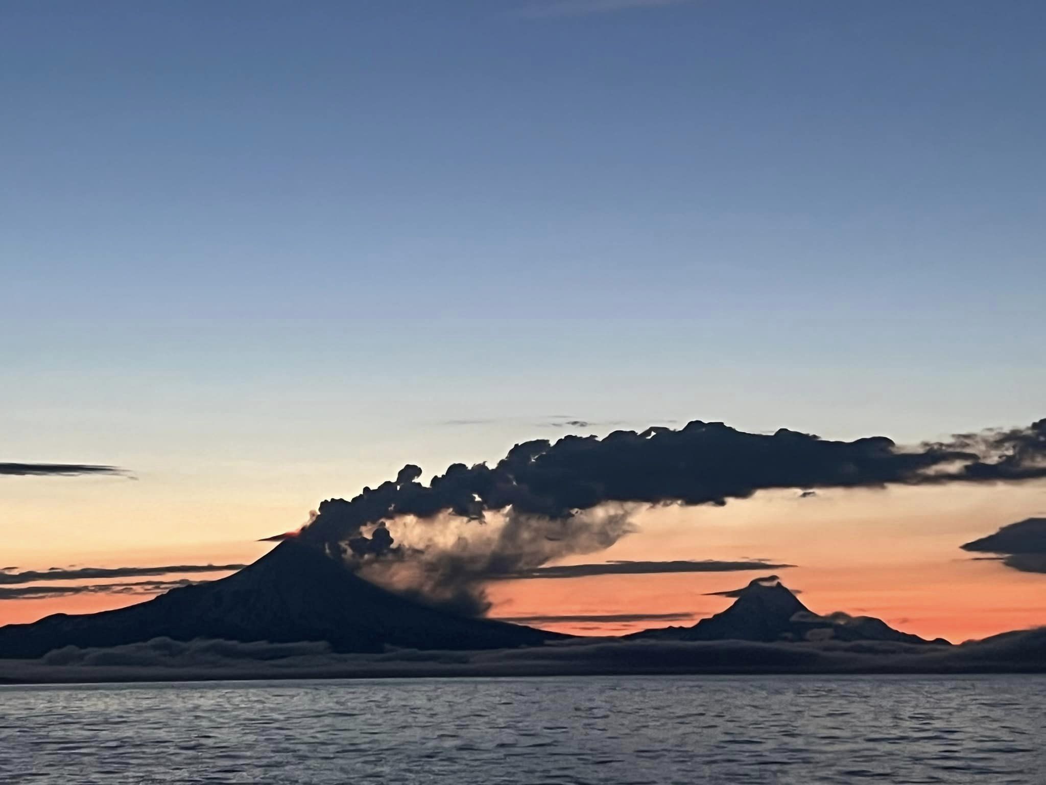
Significant ash emissions on both days were preceded by around 6 hours of heightened eruptive activity, including elevated seismic tremor, infrasound signals, and increased surface temperatures visible in satellite images. Incandescence was visible in clear web camera images, but no lava flow activity was observed outside of the summit crater .
High-resolution satellite images acquired after the activity on July 16 and July 18 showed pyroclastic deposits from the eruption extending as far as 1.9 miles (3 km) from the vent . These deposits generated mudflows that extended further down drainages on the volcano’s flanks. Ash deposits were focused to the south-southeast, downwind from the vent, and extended to the shore of Unimak Island.
Following the July 18 episode, clear satellite images showed elevated surface temperatures consistent with low-level eruptive activity in the summit crater. No significant ash emissions were observed in clear web camera images or satellite data, although mostly cloudy conditions obscured views of the volcano in the last few days. Seismicity has remained at low levels and no infrasound signals of explosive activity have been detected.

Eruptive activity could increase again rapidly with little or no warning. Before the current activity, the 2019–2020 eruption of Shishaldin was the first to result in lava flows outside of the crater area since 1976. Minor eruptions in 2004 and 2014 erupted lava confined to the summit crater. Eruptions from Shishaldin have produced ash clouds in the past similar to those seen during the current eruption, most recently in January 2020. Satellite, seismic, and infrasound data is routinely monitored for signs of explosions that might produce ash clouds.
Shishaldin Volcano is monitored by local seismic and infrasound sensors, web cameras, and a telemetered geodetic network. The local monitoring network has been partially impaired over the last few weeks due to telecommunications issues but seismic stations and web cameras south of the volcano were brought back online on July 19. In addition to the local monitoring network, AVO uses nearby geophysical networks, regional infrasound and lighting data, and satellite images to detect eruptions.
Source : AVO
Photos : Nick Enloe via Sherine France
La Réunion , Piton de la Fournaise :
Press release from the Institut de physique du globe de Paris, Volcanological Observatory of Piton de la Fournaise, July 21, 2023 – 09:15 – 05:15 UTC
Ongoing eruption
The eruption started on 02/07/2023, around 08:30 local time continues. The amplitude of the volcanic tremor (indicator of an emission of lava and gas on the surface) is always fluctuating over time on the scale of a few tens of minutes, with phases of continuous tremor and phases of intermittent tremor. The amplitude of the tremor nevertheless remains low compared to the start of the eruption.
The fluctuations observed in the tremor are reflected at the level of the eruptive site by variations in intensity in the activity, with projections of lava fountains at the level of the eruptive cone more or less intense.
Given the poor weather conditions this morning on site:
– no visual feedback on the eruptive site and the lava field could be made,
– nor any estimate of lava flows by satellite method.
But the observations of this night and early this morning still showed activity with lava projections at the level of the eruptive cone and lava flows at altitudes above 1500 m.
The flow front has not changed since July 5 and is still 1.8 km from the road.
Low inflation of the summit area is still recorded, indicating a re-pressurization of the volcano’s feeder system with possible transfer of deep magma to the latter.
The seismic activity recorded under the summit zone remains weak. Thus over the last 24 hours, no superficial volcanotectonic earthquake has been recorded. This low seismic activity leads to a reduction in the risk of the appearance of a new crack and/or collapse in the crater, but does not mean that it can be excluded.
Alert level: Alert 2-1 (eruption in the Enclos without any particular threat to the safety of people, property or the environment).
Source : OVPF
Photo : Volcanoexplorer.re Tunnels de lave Réunion/ Vincent Cheville.
Kamchatka , Klyuchevskoy :
56.06 N, 160.64 E;
Elevation 4750 m (15580 ft)
Aviation Colour Code is YELLOW
The explosive-effusive eruption of the volcano continues. Ash explosions up to 6 km (19,700 ft) a.s.l. could occur at any time. Ongoing activity could affect low-flying aircraft.
The summit eruption of the volcano continues. Against the background of explosive activity of the Strombolian type (lava fountaining in the volcanic crater), on July 19, a lava flow began to effuse along the Apakhonchich chute on the southeastern slope of the volcano. Satellite data by KVERT showed a bright thermal anomaly over the lava dome all week.
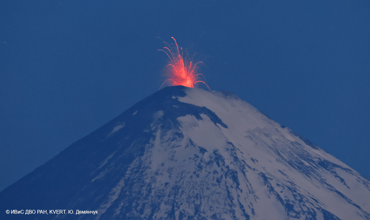
Klyuchevskoy (also spelled Kliuchevskoi) is Kamchatka’s highest and most active volcano. Since its origin about 6000 years ago, the beautifully symmetrical, 4835-m-high basaltic stratovolcano has produced frequent moderate-volume explosive and effusive eruptions without major periods of inactivity. It rises above a saddle NE of sharp-peaked Kamen volcano and lies SE of the broad Ushkovsky massif. More than 100 flank eruptions have occurred during the past roughly 3000 years, with most lateral craters and cones occurring along radial fissures between the unconfined NE-to-SE flanks of the conical volcano between 500 m and 3600 m elevation. The morphology of the 700-m-wide summit crater has been frequently modified by historical eruptions, which have been recorded since the late-17th century. Historical eruptions have originated primarily from the summit crater, but have also included numerous major explosive and effusive eruptions from flank craters.
Source : Kvert , GVP.
Photo : Yu. Demyanchuk. IVS FEB RAS, KVERT ( Archive)
Philippines , Mayon :
LAHAR ADVISORY FOR MAYON VOLCANO , 21 July 2023, 10:00 AM
Based on its Weather Advisory #5 issued at 11:00 AM on 20 July 2023, the Philippine Atmospheric Geophysical and Astronomical Services Administration (PAGASA) has estimated that a Low Pressure Area (LPA) exists approximately 700 km east of Borongan, Eastern Samar which will bring cloudy skies with scattered rainshowers and thunderstorms across the Bicol Region including Albay Province. It is further expected that the LPA will develop into a Tropical Depression (TD) named “EGAY” which can bring moderate to heavy rain between Sunday (23 July 2023) and Monday (24 July 2023).
Due to this development, communities in pre-determined areas with lahar hazards from Mayon Volcano are strongly recommended to be vigilant and ready. The incoming tropical depression is expected to bring about prolonged and heavy rainfall which may generate syn-eruption lahars along major channels draining the Mayon Volcano edifice by incorporating loose material from thick pyroclastic density current (PDC) deposits and ashfall from the ongoing 2023 eruption. The bulk of erodible PDC deposits currently occupy the watershed areas of the Mi-isi, Bonga and Basud Channels.
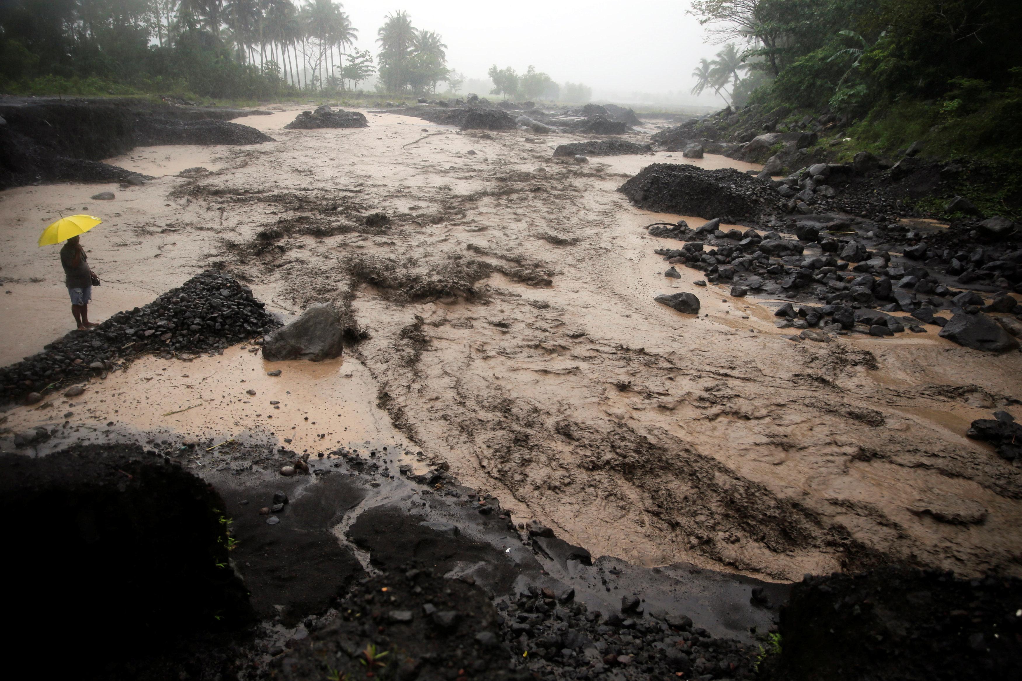
In addition, older and erodible eruption deposits occupy the watershed areas on the eastern and western slopes of the edifice and can be remobilized as non-eruption lahars by erosion of banks and channel beds. Mayon lahars can threaten communities along the middle and lower slopes and downstream of these channels with inundation, burial, and wash away.
DOST-PHIVOLCS, therefore, warns of potential lahars and sediment-laden streamflows on all river channels draining the slopes of Mayon Volcano, particularly the Mi-isi, Binaan, Anoling, Quirangay, Maninila, Masarawag, Muladbucad, Nasisi, Mabinit, Matan-ag, and Basud Channels, that may be generated by heavy rainfall brought about by TD “EGAY”. Communities and local government units beside these drainages are advised to be additionally vigilant and to move residents to high ground should heavy rains occur.
Source : Phivolcs
Photo : Auteur inconnu ( Archive)
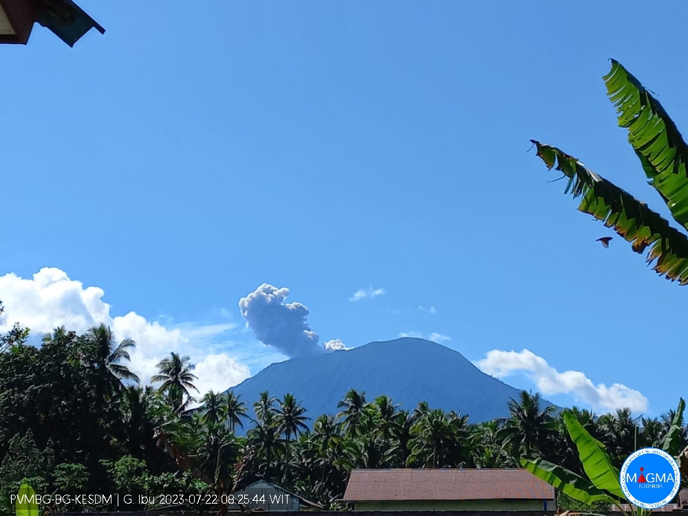
Indonesia , Ibu :
G. Ibu presented an eruption on Saturday July 22, 2023 at 10:10 a.m. WIT with the height of the ash column observed at ± 800 m above the summit (± 2125 m above sea level). The ash column was observed to be gray with a thick intensity, oriented northwest. This eruption was recorded on a seismograph with a maximum amplitude of 28 mm and a duration of 74 seconds.
VOLCANO OBSERVATORY NOTICE FOR AVIATION – VONA
Issued : July 22, 2023
Volcano : Ibu (268030)
Current Aviation Colour Code : ORANGE
Previous Aviation Colour Code : orange
Source : Ibu Volcano Observatory
Notice Number : 2023IBU019
Volcano Location : N 01 deg 29 min 17 sec E 127 deg 37 min 48 sec
Area : North Maluku, Indonesia
Summit Elevation : 4240 FT (1325 M)
Volcanic Activity Summary :
Eruption with volcanic ash cloud at 01h10 UTC (10h10 local).
Volcanic Cloud Height :
Best estimate of ash-cloud top is around 6800 FT (2125 M) above sea level or 2560 FT (800 M) above summit. May be higher than what can be observed clearly. Source of height data: ground observer.
Other Volcanic Cloud Information :
Ash cloud moving to northwest. Volcanic ash is observed to be gray. The intensity of volcanic ash is observed to be thick.
Remarks :
Eruption recorded on seismogram with maximum amplitude 28 mm and maximum duration 74 second.
Source et photo : Magma Indonésie .