July 19 , 2023.
Alaska , Shishaldin :
AVO/USGS Volcanic Activity Notice
Current Volcano Alert Level: WARNING
Previous Volcano Alert Level: WATCH
Current Aviation Color Code: RED
Previous Aviation Color Code: ORANGE
Issued: Tuesday, July 18, 2023, 7:56 AM AKDT
Source: Alaska Volcano Observatory
Notice Number: 2023/A1082
Location: N 54 deg 45 min W 163 deg 58 min
Elevation: 9373 ft (2857 m)
Area: Aleutians
Volcanic Activity Summary:
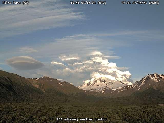
The eruption of Shishaldin Volcano has intensified. A rapidly growing ash cloud was observed starting at 7:00 am AKDT (15:00 UTC) and drifting SSE. Cloud height is undertermined at this time and could be more than 20,000 ft. above sea level (6 km). In response, the aviation Color Code is being raised to RED and the Volcano Alert Level is being raised to WARNING. The National Weather Service has issued a SIGMET for this activity.
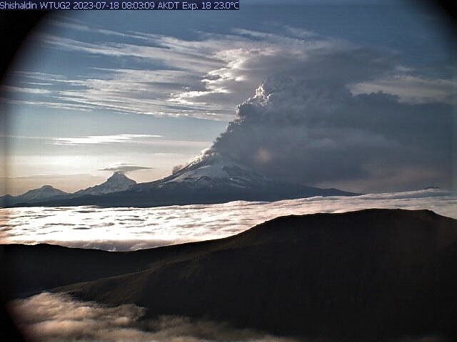
Eruptive activity began increasing overnight starting around 1 am AKDT (09:00 UTC) with increased lava eruption from or within the summit crater but no significant ash emissions. Activity was detected on regional infrasound arrays, increasing seismic tremor, and elevated surface temperatures in satellite data. Overnight webcam images confirmed glowing from the summit with only minor ash emission.
Eruptions from Shishaldin have produced minor and on occasion significant ash clouds in the past. These can occur with little warning. Shishaldin is monitored by local seismic and infrasound sensors, web cameras, and a telemetered geodetic network. The local monitoring network is partially impaired, therefore AVO is also using nearby geophysical networks, satellite data and regional infrasound and lighting data to detect activity. AVO will continue to closely monitor unrest at Shishaldin Volcano.
Recent Observations:
[Volcanic cloud height] unknown at this time, appear to have rapid growth over 20,000 ft. asl
[Other volcanic cloud information] SSE Drifting ash cloud seen in satellite imagery, see current NWS SIGMET
Hazard Analysis:
[Ash cloud] SSE drifting ash cloud observed in satellite data, see current NWS SIGMET
[Ashfall] trace ashfall possible downwind of the volcano.
[Mud flow] on all flanks of the volcano
Issued: Tuesday, July 18, 2023, 8:37 AM AKDT
Volcanic Activity Summary:
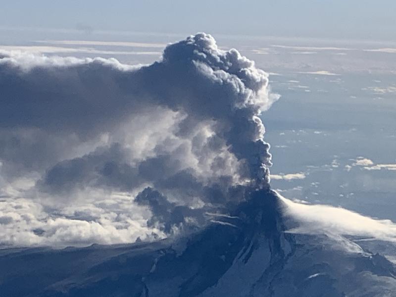
An ash cloud with an initial height of around 30,000 ft. (7 km) above sea level from Shishaldin volcano began at 7:00 am AKDT (15:00 UTC) and is drifting SSE. The eruption is continuing and recent pilot observations estimated a 24,000 ft. (6 km) above sea level height. The aviation Color Code remains at RED and the Volcano Alert Level at WARNING. The National Weather Service has issued a SIGMET for this activity.
Eruptive activity began increasing overnight starting around 1 am AKDT (09:00 UTC) with increased lava eruption from or within the summit crater but no significant ash emissions. Activity was detected on regional infrasound arrays, increasing seismic tremor, and elevated surface temperatures in satellite data . Webcam images confirmed glowing from the summit with only minor ash emission.
Issued: Tuesday, July 18, 2023, 12:08 PM AKDT
Volcanic Activity Summary:
The eruption of Shishaldin Volcano has gradually declined. Current observations indicate continued but low-level ash emissions below 10,000 ft. (3 km) above sea level and drifting to the south. Reflecting this lower-level activity, the Aviation Color Code is being reduced to ORANGE and the Volcano Alert Level is being lowered to WATCH.
This morning a significant ash plume was detected starting around 7:00 am AKDT (15:00 UTC) and reaching a height of around 30,000 ft. (7 km) above sea level. Around 9:30 am AKDT (17:30 UTC) satellite data showed the main initial plume had detached but residual, low-level ash emissions continued from the vent. The detached plume is still visible between 60–280 mi (100 and 450 km) away from the volcano.
Source : AVO.
Photos : WTUG webcam, AVO , False Pass SW, FAA weather cam, Woodsen Saunders , avo( archive).
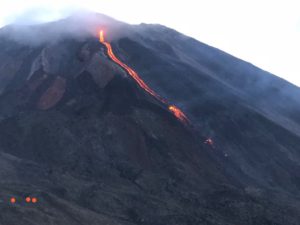
La Réunion , Piton de la Fournaise :
Press release from the Paris Institute of Earth Physics, Piton de la Fournaise Volcanological Observatory, July 18, 2023 – 10:30 a.m. – 06:30 a.m. UTC
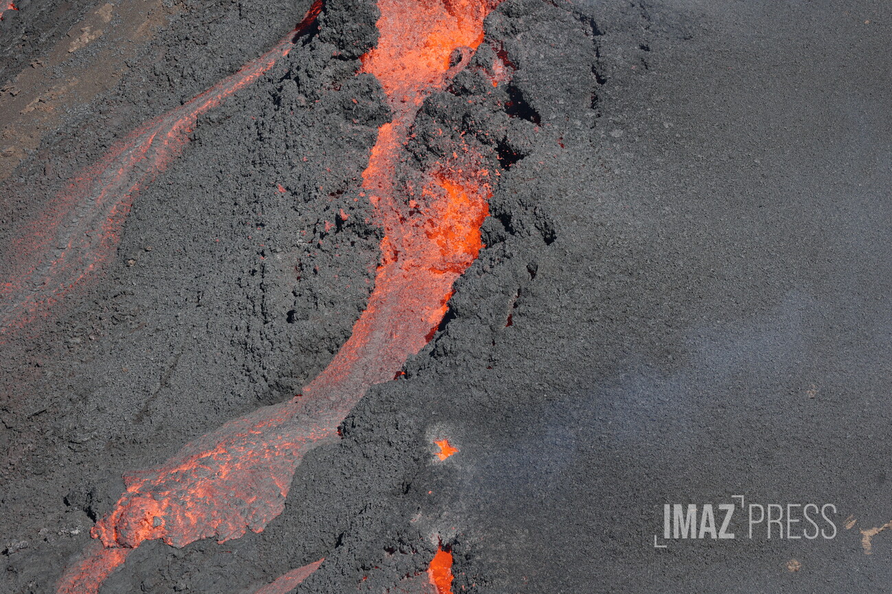
Ongoing eruption
The eruption which began on July 02, 2023, around 08:30 local time continues. The amplitude of the volcanic tremor, (indicator of an emission of lava and gas on the surface) is always fluctuating over time on the scale of a few tens of minutes, with phases of continuous tremor and phases of intermittent tremor . The amplitude of the tremor nevertheless remains low compared to the beginning of the eruption and shows a new downward trend for the last few days.
The fluctuations observed in the tremor are reflected at the level of the eruptive site by variations in intensity in the activity, with projections of lava fountains at the level of the eruptive cone more or less intense.
Given the persistent bad weather conditions currently on site:
– no visual feedback on the eruptive site and the lava field could be made today and tonight,
– nor any estimate of lava flows by satellite method.
The flow front has not changed since July 5 and is still 1.8 km from the road.
A resumption of inflation in the summit area seems to be taking shape. This parameter will be confirmed in the coming days. It could be an indicator of a deep magma transfer to the superficial feeding system.
The seismic activity recorded under the summit zone remains weak. Thus over the last 24 hours, four superficial volcano-tectonic earthquakes have been recorded. This low seismic activity leads to a reduction in the risk of the appearance of a new crack and/or collapse in the crater, but does not mean that it can be excluded.
Alert level: Alert 2-1 (eruption in the Enclos without any particular threat to the safety of people, property or the environment).
Source : OVPF
Photo : RB/www.imazpress.com
Italy / Sicily , Etna :
WEEKLY BULLETIN, from July 10, 2023 to July 16, 2023. (issue date 18 July 2023)
ACTIVITY STATUS SUMMARY
In the light of the monitoring data, it is highlighted:
1) VOLCANOLOGICAL OBSERVATIONS: Degassing activity at the level of the summit craters, in particular at the level of the Bocca Nuova crater and eruptive activity of the Strombolian type at the level of the Southeast crater.
2) SEISMOLOGY: The seismicity of the week was characterized by the occurrence of a single event with M>2.0. The amplitude of the volcanic tremor remained at average values and the location of the centroid of the sources of the volcanic tremor remains in the area of the Southeast crater.
3) INFRASOUND: Moderate increase with sources located at the Southeast and Bocca Nuova craters.
4) GROUND DEFORMATIONS: During the last week, the ground deformation monitoring networks have not recorded any significant variations.
5) GEOCHEMISTRY: SO2 flux at an average level.
Soil CO2 flux in average values.
Isotope ratio of helium on high values.
CO2 dissolved in the Ponteferro drainage tunnel without significant changes.
6) SATELLITE OBSERVATIONS: Thermal activity observed from the satellite was generally weak.
VOLCANOLOGICAL OBSERVATIONS
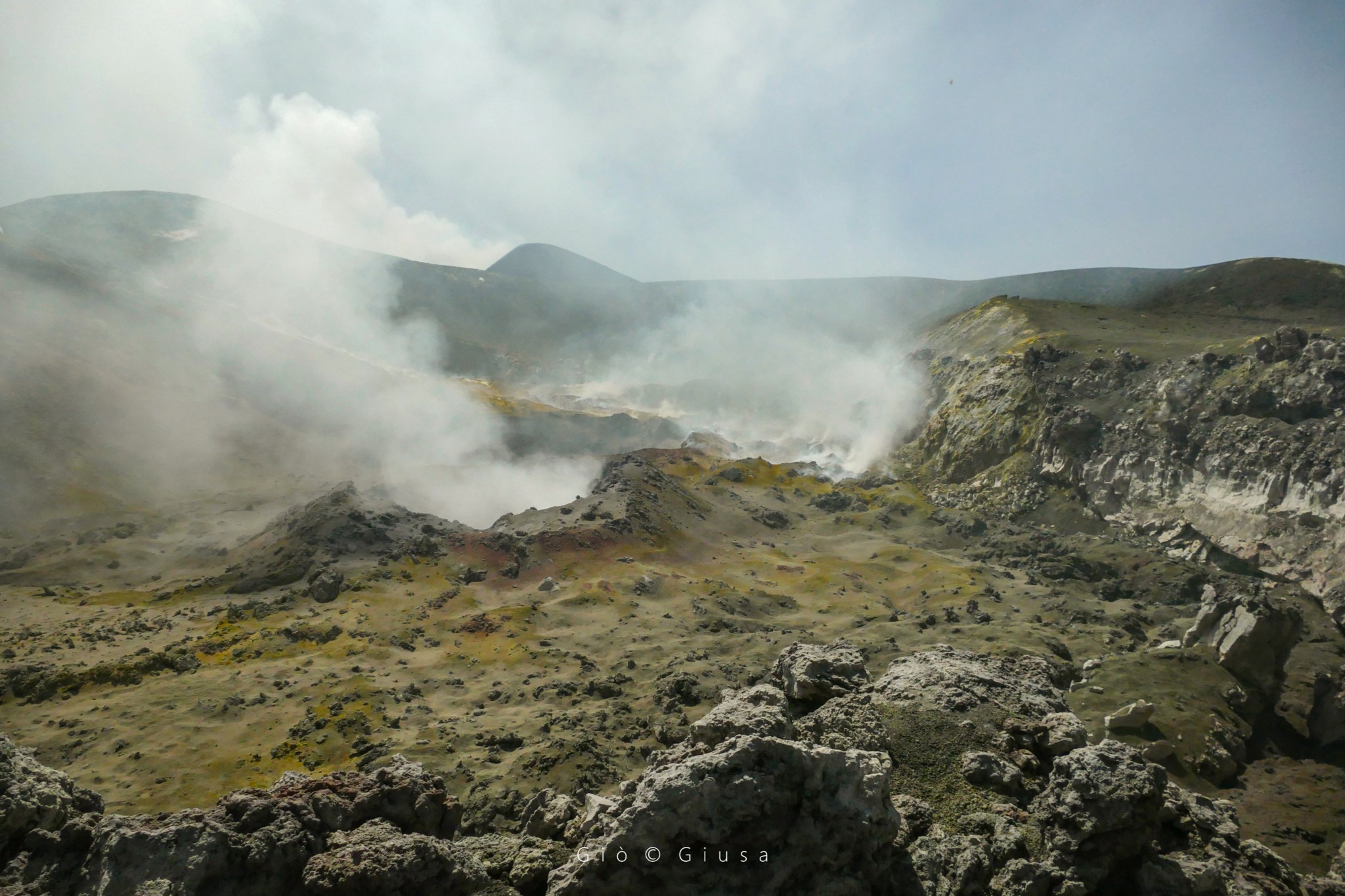
The follow-up of the volcanic activity of Etna during the observation period was carried out thanks to the analysis of the images acquired by the network of surveillance cameras of the INGV, Osservatorio Etneo (INGV-OE) and through observations with thermal cameras and drones acquired during different inspections in the summit area.
Overall, the volcanic activity of Etna was characterized by a variable level degassing of the summit craters and by the resumption of eruptive activity at the level of the Southeast crater. In particular, during the week, the Southeast crater showed continuous degassing with occasional intervals of modest ash emissions with rapid dispersion in the atmosphere. This state of activity evolved on July 14 at 18:34 UTC with the start of a modest Strombolian-type eruptive activity confined inside the crater and fed by a vent located in the eastern sector of the Southeast crater. With the exception of a verified ash emission at 18:37 UTC, the activity produced no significant ash production. Activity at other craters in the period continued with no noticeable variations from previous weeks, with Bocca Nuova continuing to be characterized by a type of impulsive degassing coupled with roars caused by pressurized gases and flashes visible at night due to the high temperature of the gases. Finally, the Voragine and the Northeast Crater still maintain a state of absence of activity on the first and slight degassing of the fumarolic type on the second.
Inspections in the summit area between July 12 and 14, 2023
Among the various inspections in the summit area carried out during the period under review, during those carried out between July 12 and 14, the state of the craters was observed using a thermal camera and drones.
The inversion of the data made it possible to characterize in detail the state of activity and the craters and their morpho-structural arrangement. Characterizations for each crater are reported below.
– Bocca Nuova crater: the data indicate thermal anomalies on the ground up to 550°C (+/-20°C) of the fumarolic field of the BN1 and BN2 vents, with explosions at BN1 with a variable frequency of 5 to 15 minutes .
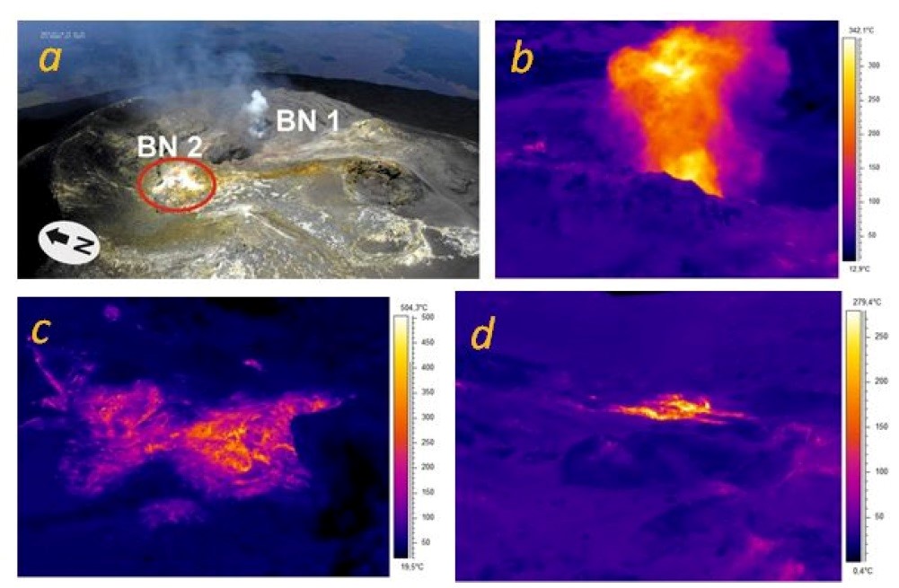
Observations of the Bocca Nuova using drones (a) and thermal camera (b-d). In (c) panoramic view of the crater taken from the West with BN2 in the foreground and BN1 immediately after, in the background of the image the fumarolic field anomaly.
The BN2 thermal anomaly extends over approximately 50×50 m (red circles in a).
– Southeast Crater: the inspection of July 12 indicated a state of generalized degassing in particular of the edges of the crater and the absence of eruptive activity. From a morpho-structural point of view, on the southwest side of the crater several concave fractures were found with a morphology similar to detachment niches, very superficial with a length varying between approximately 150 and 200 m with slight thermal anomalies in the surrounding areas.
The anomalies are probably attributable to the rheomorphic deposition of the products of the May 21 activity. Finally, another thermal anomaly was observed in the area under the rim of the crater of the North-East vent, in correspondence with a small niche (estimated length less than 30 m; ).
-Voragine and North-East Crater: the thermal camera survey shows the absence of eruptive activity in the two craters, with low temperatures or slight anomalies associated with the internal fumarolic zones of the CNE.
Source : OVPF
Photos : Gio Giusa , INGV.
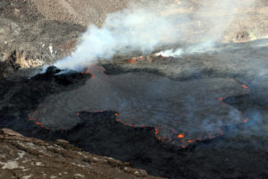
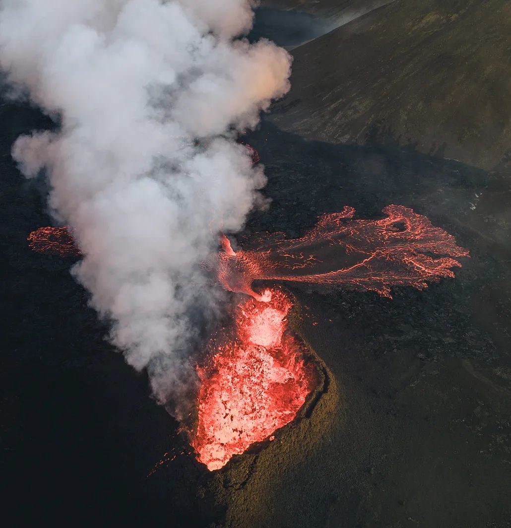
Iceland , Litli Hrútur :
July 18, 2023
New data came from the Pléiades satellite yesterday afternoon.
Lava flow measurements (July 17)
The images were obtained from the Pléiades satellite around July 13 and Landmæring Íslands prepared a terrain model from the photos. Measurements show that the lava flow over the past four days (July 13-17) has averaged nearly 13 m 3 /s. This is slightly lower than it was between July 11 and 13 (14.5 m3/s), but given the uncertainty of the measurements, the difference is not significant. The lava had reached 0.83 km 2 and its volume was 8.4 million cubic meters. The lava margin moved an average of 300 to 400 meters per day, but the movement varies considerably from day to day. The maximum lava thickness is more than 20 meters, while the average thickness is about 10 meters.
The production of the Litli Hrútur eruption during these first seven days is very similar to the eruption of Meradälar 2022, but 2 to 3 times higher than that of Geldingadälar 2021.
Chemical Composition Measurements (July 12)
The lava that appeared at the start of the eruption at Litli Hrútur is of a similar type to the lava that appeared at the end of the eruption in 2021 and in August last year. For example, the concentration of MgO is comparable and the K2O/TiO2 ratio is almost the same. Lava also contains crystals that shed light on changing crystallization conditions.
The chemical composition of the gas is also comparable to that of the start of the 2022 eruption, with a relatively high concentration of carbon dioxide (CO2), which probably accumulated during the preparation of the July 10 eruption. .
These results therefore indicate a link with the eruption that characterized most of the 2021 eruption, but also the eruption that took place in 2022. The exact relationship between these eruptions calls for more detailed research. Interestingly, there is no immediate bubble similar to what occurred during the initial phase of these events in March 2021.
Source : jardvis.hi.is.
Photo : Arvind Jayashankar Photography via Sherine France.
Alaska , Tanaga / Takawangha :
AVO/USGS Volcanic Activity Notice
Current Volcano Alert Level: NORMAL
Previous Volcano Alert Level: ADVISORY
Current Aviation Color Code: GREEN
Previous Aviation Color Code: YELLOW
Issued: Tuesday, July 18, 2023, 4:28 PM AKDT
Source: Alaska Volcano Observatory
Notice Number: 2023/A1092
Location: N 51 deg 53 min W 178 deg 8 min
Elevation: 5925 ft (1806 m)
Area: Aleutians
Volcanic Activity Summary:
Earthquake activity near Tanaga Volcano has decreased in both rate and magnitude from the peak of the swarm on March 9–11 when over 150 earthquakes per day were located on Tanaga Island to less than 3 earthquakes per day in the last few weeks. Recent satellite images do not indicate any ongoing deformation on the island. No other signs of volcanic unrest have been detected. The Alaska Volcano Observatory is therefore lowering the Aviation Color Code to GREEN and the Volcano Alert Level to NORMAL.
The Alaska Volcano Observatory will continue to closely monitor seismic activity on Tanaga Island.
AVO/USGS Volcanic Activity Notice
Current Volcano Alert Level: NORMAL
Previous Volcano Alert Level: ADVISORY
Current Aviation Color Code: GREEN
Previous Aviation Color Code: YELLOW
Issued: Tuesday, July 18, 2023, 4:28 PM AKDT
Source: Alaska Volcano Observatory
Notice Number: 2023/A1093
Location: N 51 deg 52 min W 178 deg 1 min
Elevation: 4754 ft (1449 m)
Area: Aleutians
Volcanic Activity Summary:
Earthquake activity near Takawangha Volcano has decreased in both rate and magnitude from the peak of the swarm on March 9–11 when over 150 earthquakes per day were located on Tanaga Island to less than 3 earthquakes per day in the last few weeks. Recent satellite images do not indicate any ongoing deformation on the island. No other signs of volcanic unrest have been detected. The Alaska Volcano Observatory is therefore lowering the Aviation Color Code to GREEN and the Volcano Alert Level to NORMAL.
The Alaska Volcano Observatory will continue to closely monitor seismic activity on Tanaga Island.
Source : AVO.
Photos : Clifford, Roger , Coombs, M. L.