July 14 , 2023.
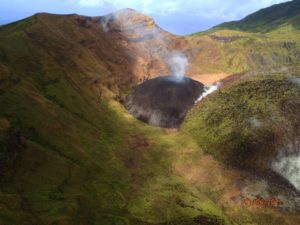
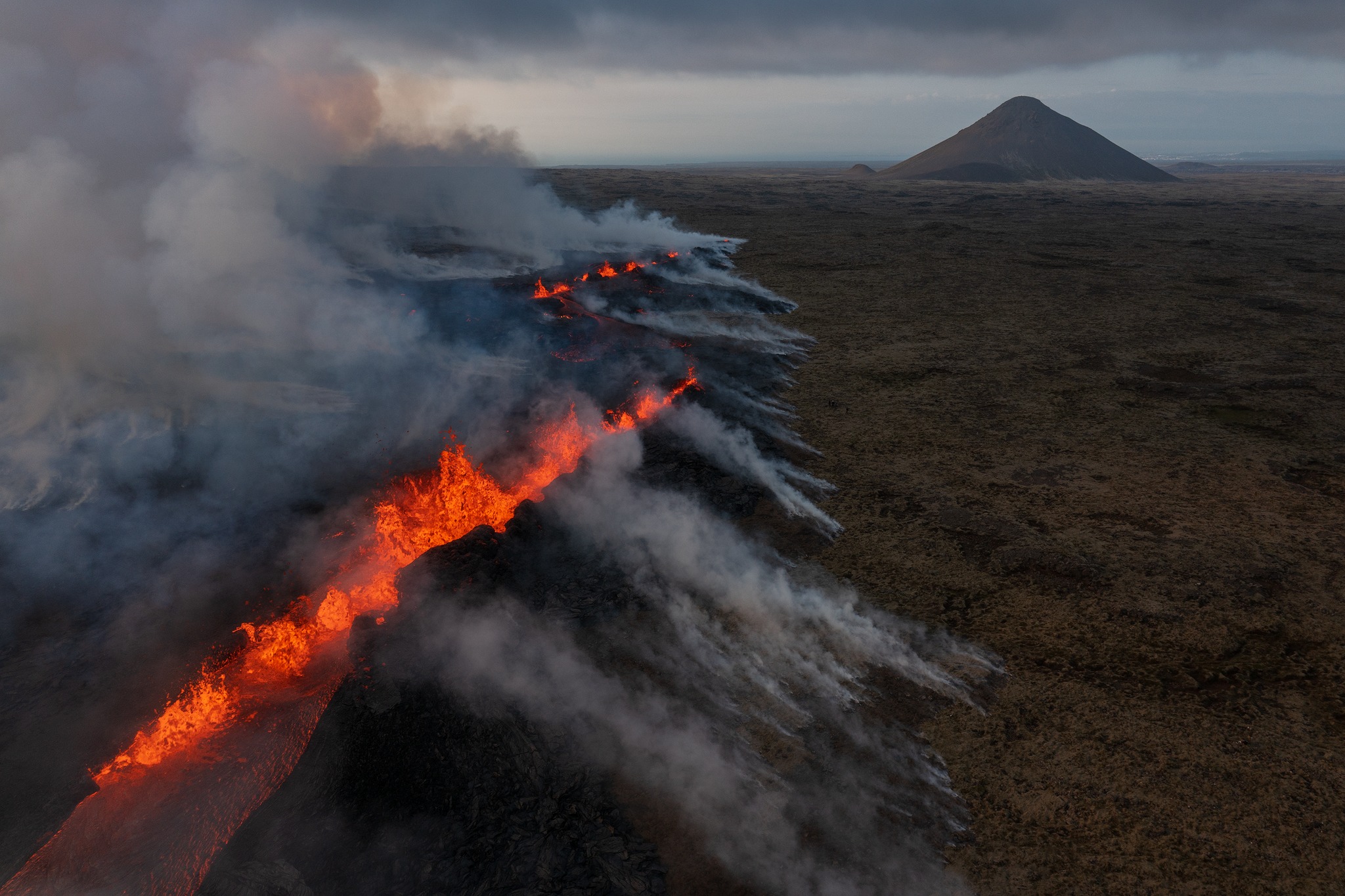
Iceland , Litli Hrútur :
Latest news on the volcanic eruption on the Reykjanes peninsula
Updated on July 12, 2023 at 2:00 p.m.
Since the start of the eruption on Monday afternoon July 10, around 300 earthquakes have been recorded on the Reykjanes peninsula. Most of the earthquakes were below magnitude 2.0, but two were measured larger, they were magnitude 2.0 and 2.1. This image below shows the evolution of the eruption over the past three days. Prior to the eruption, the tremors are most visible on the graph.
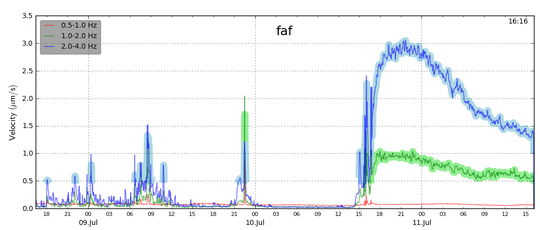
The unrest can be seen increasing rapidly from 3 p.m. on Monday July 10 and peaking around 9 p.m. The tremor graph shows a signal at three different frequencies, and it is clearly seen that the blowout tremor is greatest at the highest frequency, 2-4 Hz. Now that the blowout has started, we can see expect seismic activity in the area to continue to decline.
Updated on July 13, 2023 at 2:30 p.m.
This COSMO-SkyMed interferogram covers the period from June 27 to July 12, 2023 and shows ground deformation before and during the first two days of the eruption. Each cycle of colored fringes represents 1.55 cm of deformation in the line of sight of the satellite. Relative to the dyke intrusion, more than 50 cm of extensional movement is observed in the NW and SE directions (~1 m of total outward movement across the interferogram).
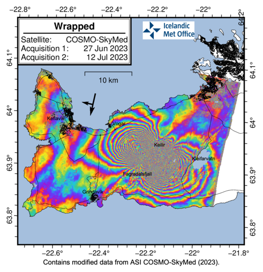
These outward movements occur perpendicular to the axis of the dyke and represent expansion to the northwest and southeast, in response to the influx of magma into the dyke. As reported yesterday, GPS observations since the start of the eruption show that the deformation is receding into the background suggesting a balance between the entry and exit of magma in the eruption. At the same time, seismicity decreased significantly, which supports this interpretation.
Source : IMO.
Photos : OVPF , Mike Mezeul II , OVPF.
La Réunion , Piton de la Fournaise :
Press release from the Paris Institute of Earth Physics, Piton de la Fournaise Volcanological Observatory, July 13, 2023 – 12:00 – 08:00 UTC
Ongoing eruption
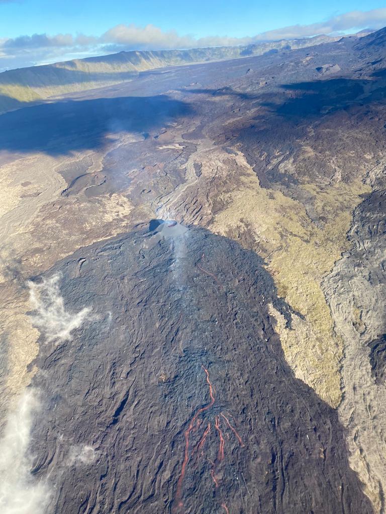
The eruption started on 02/07/2023, around 08:30 local time continues. The amplitude of the volcanic tremor (indicator of an emission of lava and gas on the surface) is always fluctuating over time on the scale of a few tens of minutes, with phases of continuous tremor and phases of intermittent tremor. The amplitude of the tremor nevertheless remains low compared to the beginning of the eruption.
The fluctuations observed in the tremor are reflected at the level of the eruptive site by variations in intensity in the activity, with projections of lava fountains at the level of the more or less intense eruptive cone.
Lava flow estimates established by satellite method on the HOTVOLC platform (OPGC – Clermont Auvergne University) over the past 24 hours still indicated flow rates between 1 and 13.5 m3 / sec. Given the mass of clouds regularly present on the eruptive site as well as the presence of lava tunnels, these flows may be underestimated.
In total, since the start of the eruption, the volume of lava emitted on the surface is estimated at 6 (± 3) million m3.
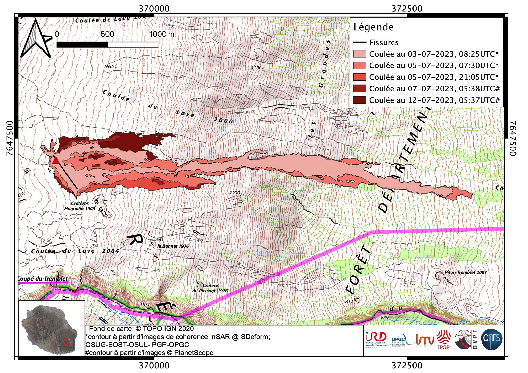
The active volcanic cone – located southeast of the Enclos Fouqué at an altitude of 1720 m and now closed laterally – continues to build by accumulating lava projections.
The lava flow now takes place mainly in lava tunnels in the immediate vicinity of the cone, even if flows are still visible at resurgence points.
Currently the growth of the lava field is mainly by widening and thickening near the eruptive cone at the level of the lava tunnel networks. Since July 7, the flow has widened by a maximum of 180 meters, mainly on its northern part and above 1500 altitude. During last night, the active flows were at altitudes above 1500 m in the upper part of the Grandes Pentes.
The flow front has not changed since July 5 and is still 1.8 km from the road.
At present, no significant deformation of the building is recorded.
The seismic activity recorded under the summit zone remains weak. Thus over the last 24 hours, 4 superficial volcanotectonic earthquakes have been recorded. This low seismic activity leads to a reduction in the risk of the appearance of a new crack and/or collapse in the crater, but does not mean that it can be excluded.
Alert level: Alert 2-1 (eruption in the Enclosure without any particular threat to the safety of people, property or the environment).
Source et photos : OVPF.
Philippines , Taal :
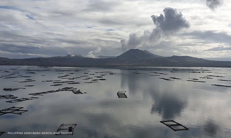
TAAL VOLCANO ADVISORY 13 July 2023 , 9:00 AM
This is a notice of recent low-level activity in Taal Volcano.
Beginning at 6:09 AM this morning, 13 July 2023, a series of seven (7) significant but shallow tremors were recorded by all 15 seismic stations of the Taal Volcano Network. Most of the events originated southeast of Taal Volcano Island or TVI. An increase in the thermal signatures of Taal Main Crater was also detected in IR camera images. Volcanic SO2 emissions in the past two weeks have been elevated, averaging 5,866 tonnes/day with a peak of 9,623 tonnes/day recorded on 6 July, 2023, while upwelling of volcanic fluids in Taal Main Crater lake has been frequently detected. Electronic tilt stations have been recording inflation of the northern flank of TVI since May 2023. These parameters indicate that shallow hydrothermal activity driven by a new phase of magma degassing at depth is currently taking place at Taal Volcano.
DOST-PHIVOLCS reminds the public that Alert Level 1 prevails over Taal Volcano, which means that it is still in abnormal condition and should not be interpreted to have ceased unrest nor ceased the threat of eruptive activity. Should current low-level activity worsen or pronounced changes in monitored parameters forewarn of increasing unrest, the Alert Level may be raised to Alert Level 2. At Alert Level 1, sudden steam-driven or phreatic explosions, volcanic earthquakes, minor ashfall and lethal accumulations or expulsions of volcanic gas can occur and threaten areas within TVI. DOST-PHIVOLCS strongly recommends that entry into TVI, Taal’s Permanent Danger Zone or PDZ, especially the vicinities of the Main Crater and the Daang Kastila fissure, must remain strictly prohibited. Local government units and communities around Taal Lake are advised to be vigilant and prepared in case of further unrest. Civil aviation authorities must advise pilots to avoid flying close to the volcano as airborne ash and ballistic fragments from sudden explosions and wind-remobilized ash may pose hazards to aircrafts.
DOST-PHIVOLCS is closely monitoring Taal Volcano’s activity and any new significant development will be immediately communicated to all stakeholders.
Source : Phivolcs
Photo : CNNPH , marcello Teofilo
Costa Rica , Poas :
Latitude: 10.2
Longitude:-84.233
Altitude: 2,687 meters
Observed activity:
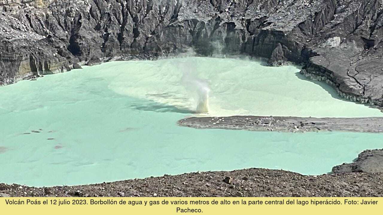
There are no eruptions but the seismographs continue to record a weak signal of volcanic tremor. Fumaroles remain active, in particular an underwater fumarole in the central part of the hyperacidic lake. This fumarole generates a gush of several meters of water and gas with strong convection of molten native sulfur. The concentration of SO2 gas in the ambient air around the visitor’s viewpoint registers up to 5 parts per million in the ExpoGAS sensor.
A smell of hydrogen sulphide (rotten egg smell) is perceived near the active crater. The network of GPS sensors records a slight deflation of the volcanic edifice.
Environmental conditions:
At the top of the volcano, the winds move the air masses towards the southwest and the conditions are mainly cloudy.
Niveau d’activité : Avertissement (2)
Source et photo : Ovsicori.
Colombia , Chiles / Cerro Negro :
Weekly activity bulletin of the volcanic complex of Chiles and Cerro Negro (CVCCN)
Regarding the monitoring of the activity of the VOLCANOES CHILES AND CERRO NEGRO, the MINISTRY OF MINES AND ENERGY through the COLOMBIAN GEOLOGICAL SERVICE (SGC) informs that:
During the week between July 4 and July 10, 2023, an increase in the number of earthquakes of about double was observed compared to the previous week; however, the seismic energy released remained at similar levels. The prevailing seismicity continued to be related to rock fracture processes and, to a lesser extent, the record of earthquakes related to the movement of fluids in the volcanic system was maintained.

It was possible to locate 254 earthquakes which, for the most part, were located towards the southern sector of the Chiles volcano, at epicentral distances of up to 4 km, depths between 2 and 7 km from its summit. (4700 m), and magnitudes that did not exceed 2.6. The July 6 earthquake at 07:14 stands out. with a magnitude of 2.6, which was reported as felt by some residents of the Chiles reserve.
The soil deformation processes continue in the volcanic edifice, detected instrumentally by the sensors installed in the volcanoes and also by remote satellite sensors.
The possibility of earthquakes of considerable energy that can be felt by residents of the area of influence remains.
The activity level of volcanoes remains at the YELLOW LEVEL ■ (III): CHANGES IN THE BEHAVIOR OF VOLCANIC ACTIVITY.
Source : SGC
Photo : IGEP.