July 07 , 2023.
La Réunion , Piton de la Fournaise :
Press release from the Paris Institute of Earth Physics, Piton de la Fournaise Volcanological Observatory, July 06, 2023 – 1:00 p.m. – 9:00 a.m. UTC.
Ongoing eruption
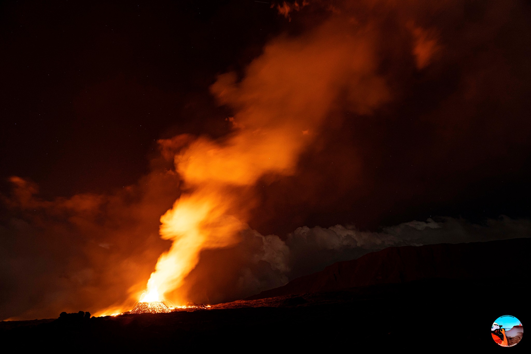
The eruption started on 02/07/2023, around 08:30 local time continues. The amplitude of the volcanic tremor (indicator of an emission of lava and gas on the surface) has entered a phase of oscillations linked to the appearance of puffs of tremor. This type of event (gas-piston) is associated with the periodic rise of gas packets in the building.
Lava flow estimates established by satellite method on the HOTVOLC platform (OPGC – Clermont Auvergne University) over the past 24 hours indicated flows between 2 and 24 m3 / sec. However, these measurements were at times greatly reduced by the presence of clouds on the eruptive site.
Images taken by drone this morning have confirmed that only the casting arms located in the upper part remain active and that the first arm put in place on Monday seems frozen. The images from the webcams obtained this morning confirm the absence of progression of the flow front. It was still this morning between 2 and 2.5 km from the RN2.
Last night, the most active parts of the lava flow were on the upper part of the Grandes Pentes.
This morning the eruptive activity was concentrated on a single emission point located southeast of the Fouqué enclos around 1700 m above sea level around which a volcanic cone continues to build.
The deflation of the entire edifice which began 72 hours ago continues. This deflation is linked to the emptying of the magmatic reservoir located about 2 km below the summit of Piton de la Fournaise which is feeding the current eruption.
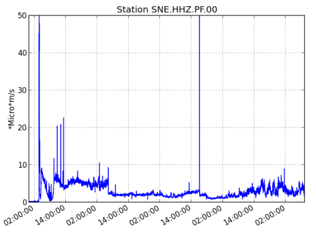
The deep seismic activity continues to decline (15 superficial volcano-tectonic earthquakes over the last 24 hours against 16 the previous day and 1059 on the first day of eruption). This reduction leads to a reduction in the risk of a new opening appearing at lower altitude, but does not mean that it can be totally excluded.
Maintaining increased vigilance is requested in the sectors bordering the North and South Enclos . Indeed, given the high probability of the emission of degassed magma, it could be that the OVPF stations located in the sector do not record a volcanic tremor if a crack were to open at low altitude. and/or outside the Enclos .
Alert level: Alert 2-1 (eruption in the Enclos without any particular threat to the safety of people, property or the environment).
Source : OVPF
Photos : Vincent Cheville / Volcanoexplorer.re Tunnels de lave Réunion. OVPF.
Iceland , Fagradalsfjall :
Earthquake activity in Fagradalsfjall area
About 4700 earthquakes since July 4th
Updated 6. July 2023 at 12:30pm
The earthquake swarm on the Reykjanes Peninsula continues, with over 1300 earthquakes detected since midnight today, 6 July. Since the beginning of the swarm on 4 July, the total number of earthquakes exceeds 4700. From midnight today, over six earthquakes exceeding magnitude 3.5 have occurred, with the largest earthquakes continuing to be felt in the south-west of the country. Overall, the intensity of the swarm has decreased slightly, both in terms of number of earthquakes and earthquake magnitudes.
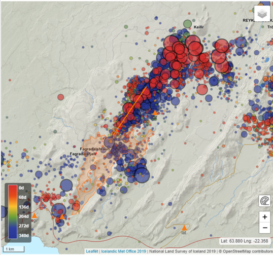
On this figure we see distribution of earthquake epicentres (circles) in the Fagradalsfjall region between 30 July 2022 and 5 July 2023. The red circles correspond to the current seismic sequence while blue to the July-August 2022 sequence. The orange line is the vertical projection of the location of the dike intrusion of 2022. The map shows reviewed epicentral location and earthquake magnitudes larger than 1, with magnitude differences indicated by relative size differences of the circles.
The spatial distribution of earthquake epicentres is on a northeast-southwest lineament between Fagradalsfjall and Keilir, mostly concentrated just north of the mountain Litli Hrútur. The latest ground deformation (GPS) observations show significant movements, indicating magma propagation in the region where earthquakes are highly concentrated. The likely explanation is a northeast-southwest trending magma intrusion at 2 to 4 km depth. The intrusion is close enough to the Earth’s surface that a volcanic eruption could occur without further escalations in seismic activity or ground deformation.

Keilir
Based on the present assessment, two outcomes are possible. The seismicity could decrease progressively without magma reaching the surface. Alternatively, the seismicity could still decrease when the magma stops moving laterally but begins to move upward towards the surface (as observed prior to the last 2 eruptions here). This would likely result in an eruption close to where seismicity is currently concentrated. However, magma reaching the surface anywhere in the region between Fagradalsfjall and Keilir cannot be excluded. Of the two possible outcomes, a volcanic eruption occurring within days or weeks is considered more likely.
While the earthquake swarm is ongoing, the main hazard is strong seismic ground motion due to the largest earthquakes in the sequence and potential triggered earthquakes on nearby faults. The largest earthquakes in the swarm have caused localised rockfalls, so people are advised against walking close to rock cliffs or steep slopes in the area around Keilir, Fagradalsfjall and Kleifarvatn.
Updated 6. July 2023 at 6pm
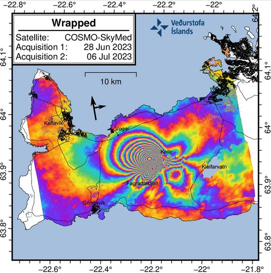
COSMO-SkyMed interferogram covering the period 28 June to 6 July 2023.
The wrapped image clearly shows a series of multicolored fringes centered bewtween Fagradalsfjall and Keilir. These fringes show ground deformation caused by the new dike intrusion which commenced on 4 July 2023. The maximum observed deformation related to the dike intrusion is up to 18 cm in the satellite‘s line-of-sight (los) in the NW direction.
Although the deformation signal extends over a large area of the western Reykjanes Peninsula, this does not mean there is magma beneath this entire region. The magma intrusion is situated bewteen Fagradalsfjall and Keilir. There is no indication of additional magma movements outside this area.
Several small lineaments are also visible in the interferogram which cut across the fringes. These represent fault movements/earthquakes that were triggered during the dike propagation.
Source : IMO.
Photos : IMO , Wikipedia.
Nicaragua , San Cristobal :
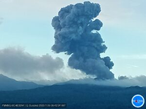
The San Cristóbal volcano, the highest in Nicaragua, records a « small eruption »
The San Cristóbal, with a height of 1,745 meters above sea level, « made a small eruption of moderate magnitude of gas and ash », said the National System for Prevention, Mitigation and Disaster Relief. watch out for disasters (Sinapred).
The San Cristóbal volcano, the highest in Nicaragua and located in the « cord of fire » of the Pacific, recorded this Wednesday a « small eruption », followed by the emanation of gas and ash, without causing any victims or damage. materials, although there is alarm among the population, authorities said.
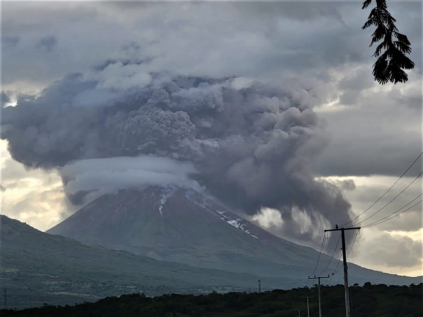
The explosions caused the expulsion of a dense column of gas and ash to a height not yet estimated above the crater, indicated, for its part, the Nicaraguan Institute of Territorial Studies (Ineter).
« The Nicaraguan government maintains monitoring of this volcano and others at the national level, » Sinapred said.
The San Cristóbal is located in the department of Chinandega, in the northwest of Nicaragua, and is part of the volcanic chain of this country.
Ineter said it was closely monitoring volcanic activity « to assess the volcano’s behavior and ensure the safety of people in the area. »
He also announced that he would provide regular updates on the behavior of the volcano.
Source : 100% Noticias
Photo : Nicas Mochileros
Kamchatka , Klyuchevskoy :
56.06 N, 160.64 E;
Elevation 4750 m (15580 ft)
Aviation Colour Code is YELLOW
The explosive eruption of the Strombolian-type of the volcano continues. Aerosole plumes with some amount of ash could occur at any time. Ongoing activity could affect low-flying aircraft.
The summit explosive eruption of Strombolian-type of the volcano continues. Since 04 July, small ash clouds began to observed occasionally over the crater. Satellite data by KVERT showed a thermal anomaly over the lava dome all week.
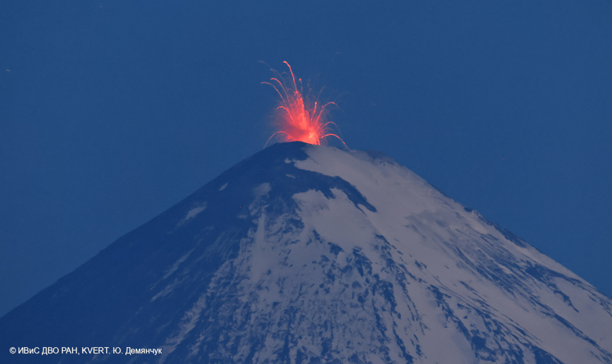
Klyuchevskoy (also spelled Kliuchevskoi) is Kamchatka’s highest and most active volcano. Since its origin about 6000 years ago, the beautifully symmetrical, 4835-m-high basaltic stratovolcano has produced frequent moderate-volume explosive and effusive eruptions without major periods of inactivity. It rises above a saddle NE of sharp-peaked Kamen volcano and lies SE of the broad Ushkovsky massif. More than 100 flank eruptions have occurred during the past roughly 3000 years, with most lateral craters and cones occurring along radial fissures between the unconfined NE-to-SE flanks of the conical volcano between 500 m and 3600 m elevation. The morphology of the 700-m-wide summit crater has been frequently modified by historical eruptions, which have been recorded since the late-17th century. Historical eruptions have originated primarily from the summit crater, but have also included numerous major explosive and effusive eruptions from flank craters.
Source : Kvert. GVP.
Photo : Yu. Demyanchuk. IVS FEB RAS, KVERT.
Philippines , Mayon :
MAYON VOLCANO BULLETIN 07 July 2023 8:00 AM
In the past 24-hour period, a very slow effusion of lava from the summit crater of Mayon Volcano continued to feed lava flows and collapse debris on the Mi-isi (south) and Bonga (southeastern) gullies as well as rockfall and PDCs on these and the Basud (eastern) Gullies. The lava flows have advanced to approximate lengths of two thousand eight hundred (2800) meters and one thousand three hundred (1300) meters along Mi-isi and Bonga gullies, respectively, from the summit crater while collapse debris has deposited to four thousand (4000) meters from the crater. Seven (7) dome-collapse pyroclastic density currents (PDC) that lasted from five (5) seconds to three (3) minutes and twenty-nine (29) seconds, eight (8) lava front collapse pyroclastic density currents (PDC) that generated 500 meters high light-brown plume, two hundred sixteen (216) rockfall events, and an ongoing repetitive pulse tremor observed since 3:47 PM (PST) of July 3, 2023, were recorded by the Mayon Volcano Network.
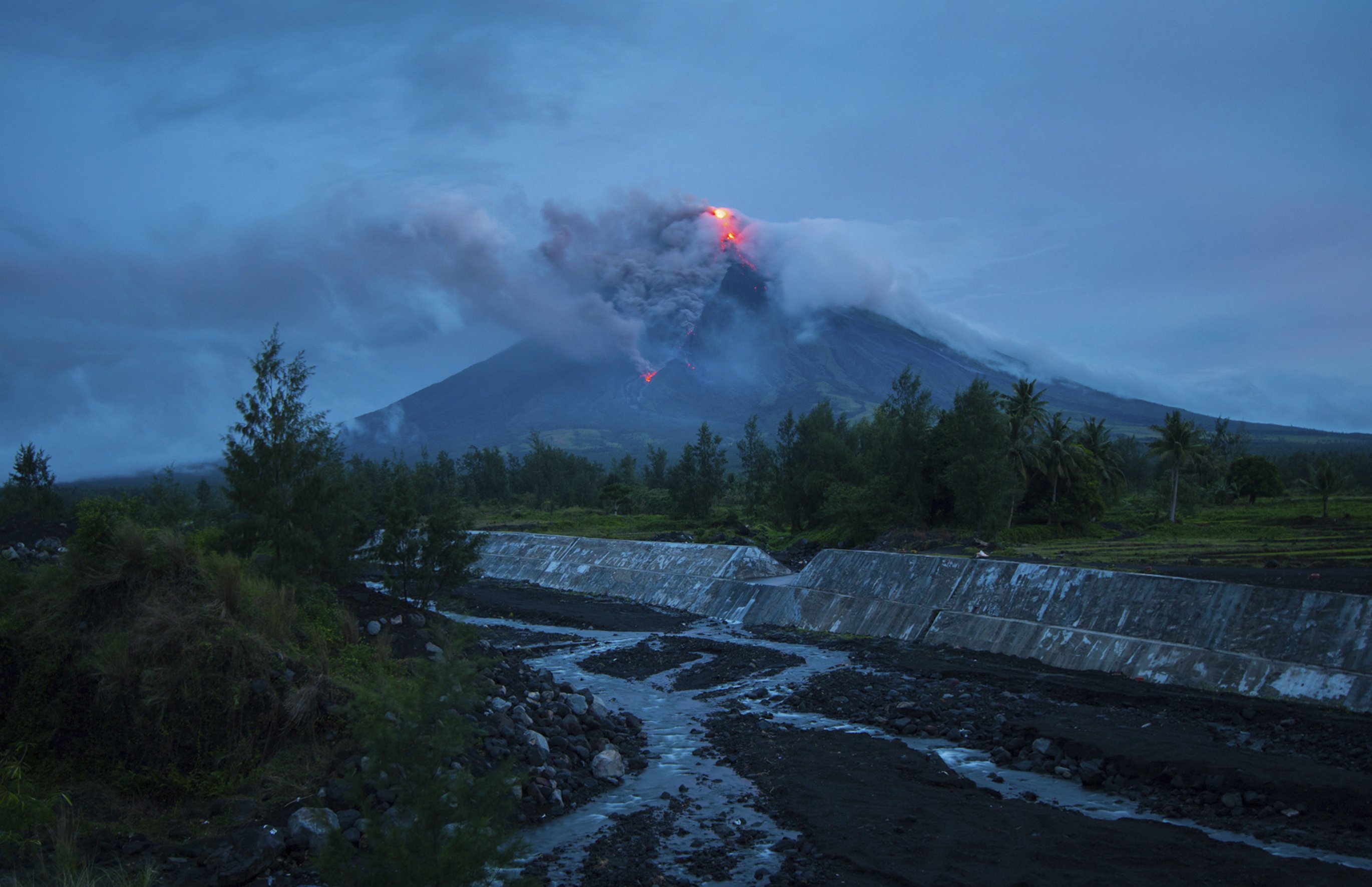
Continuous moderate degassing from the summit crater produced steam-laden plumes that rose 600 meters before drifting to the west-northwest and west-southwest. Sulfur dioxide (SO2) emission averaged 973 tonnes/day on 06 July 2023. Short-term observations from EDM and electronic tiltmeter monitoring show the upper slopes to be inflating since February 2023. Longer-term ground deformation parameters based on EDM, precise leveling, continuous GPS, and electronic tilt monitoring indicate that Mayon is still inflated, especially on the northwest and southeast.
Alert Level 3 is maintained over Mayon Volcano, which means that it is currently in a relatively high level of unrest as magma is at the crater and hazardous eruption within weeks or even days is possible.
Source : Phivolcs
Photo : Auteur inconnu.