June 26 , 2023.
Indonesia , Merapi :
Report on the activity of Mount Merapi from June 16, 2023 to June 22, 2023, Published on June 23, 2023
RESULTS OF OBSERVATIONS
Visual
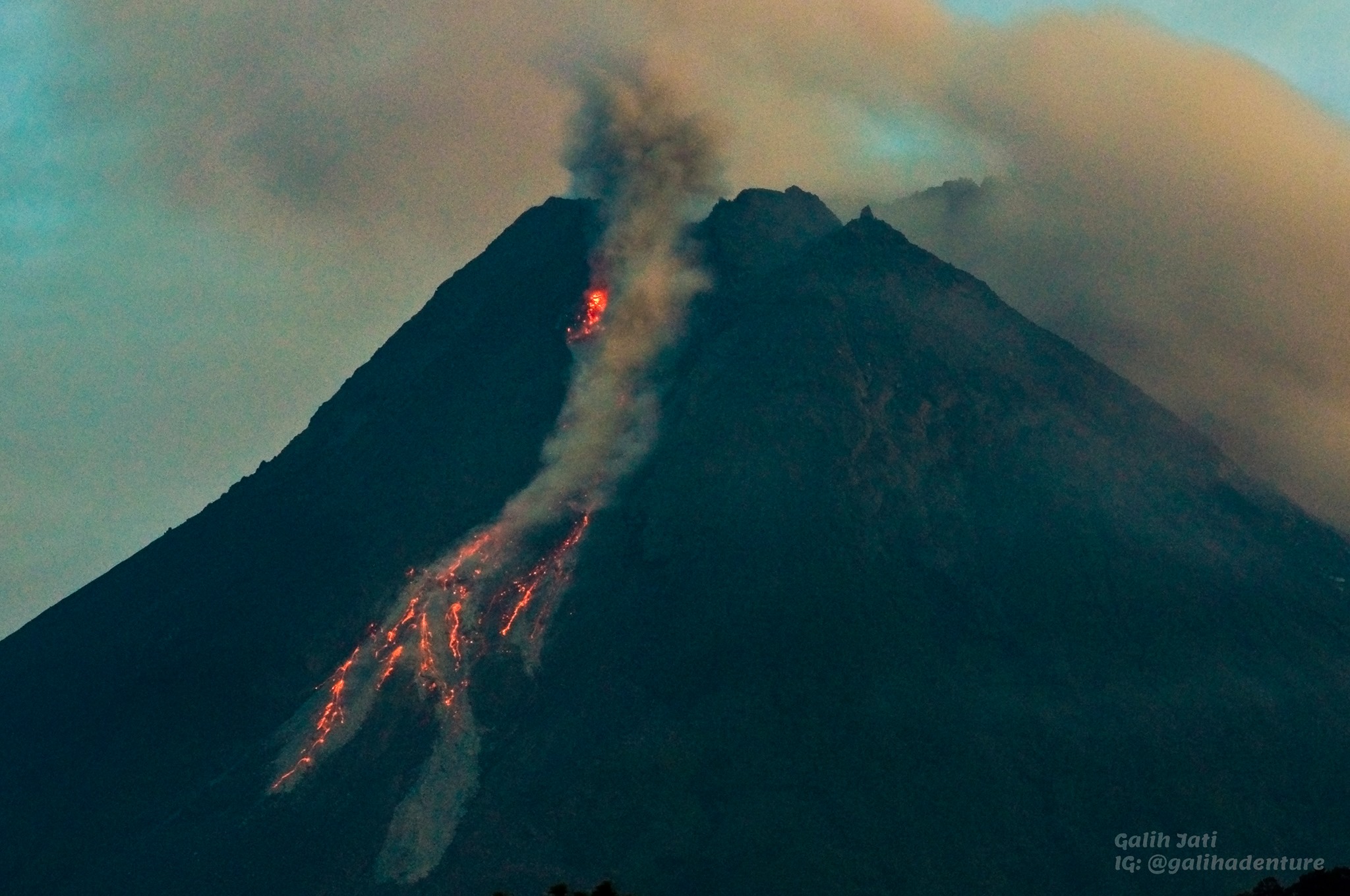
The weather around Mount Merapi is usually sunny in the morning and afternoon, while the evening is foggy. White, fine to thick smoke, low to medium pressure and 350 m high was observed from the Mount Merapi observation post in Badaban on June 20, 2023 at 05:30.
This week, lava avalanches were observed 116 times to the southwest (upstream of Kali Bebeng and Kali Boyong) with a maximum slip distance of 1800 m. The sound of the avalanches was heard 38 times from the Babadan post with low to medium intensity.
On the Southwest dome, morphological changes have been observed due to lava avalanches. For the central dome, no significant morphological change was observed. Based on the results of a drone survey on May 17, 2023, the measured volume of the Southwest dome was 2,372,800 m3 and the central dome was 2,337,300 m3.
Seismicity
This week, the seismicity of Mount Merapi showed:
12 deep volcanic earthquakes (VTB),
779 avalanche earthquakes (RF),
9 tectonic earthquakes (TT).
47 multi-phase (MP) earthquakes
13 low frequency (LF) earthquakes.
In general, the intensity of seismicity this week is higher than last week.
Deformation
Mount Merapi’s deformation that was monitored using EDM and GPS this week showed a shortening rate of 0.5cm/day.
Rain and lahars:
This week there was rainfall at the Mount Merapi observation post with a rain intensity of 4 mm/h for 45 minutes at the Kaliurang post on June 17, 2023.
Conclusion
Based on the results of visual and instrumental observations, it is concluded that:
-The volcanic activity of Mount Merapi is still quite high in the form of effusive eruption activity. The state of the activity is defined at the « SIAGA » level.
The current danger potential is in the form of lava avalanches and hot clouds in the South-South-West sector comprising the Boyong River for a maximum of 5 km, the Bedog, Krasak, Bebeng rivers for a maximum of of 7 km. In the South-East sector, it includes the Woro River for a maximum of 3 km and the Gendol River for 5 km. While the ejection of volcanic material in the event of an explosive eruption can reach a radius of 3 km from the summit.
Source : BPPTKG
Photo : Yohannes Tyas Galih Jati
Kamchatka , Sheveluch :
56.64 N, 161.32 E;
Elevation 3283 m (10768 ft),
dome elevation ~2500 m (8200 ft)
Aviation Colour Code is ORANGE
An extrusive-effusive eruption of the volcano continues. A danger of ash explosions up to 10 km (32,800 ft) a.s.l. is remains. Ongoing activity could affect international and low-flying aircraft.
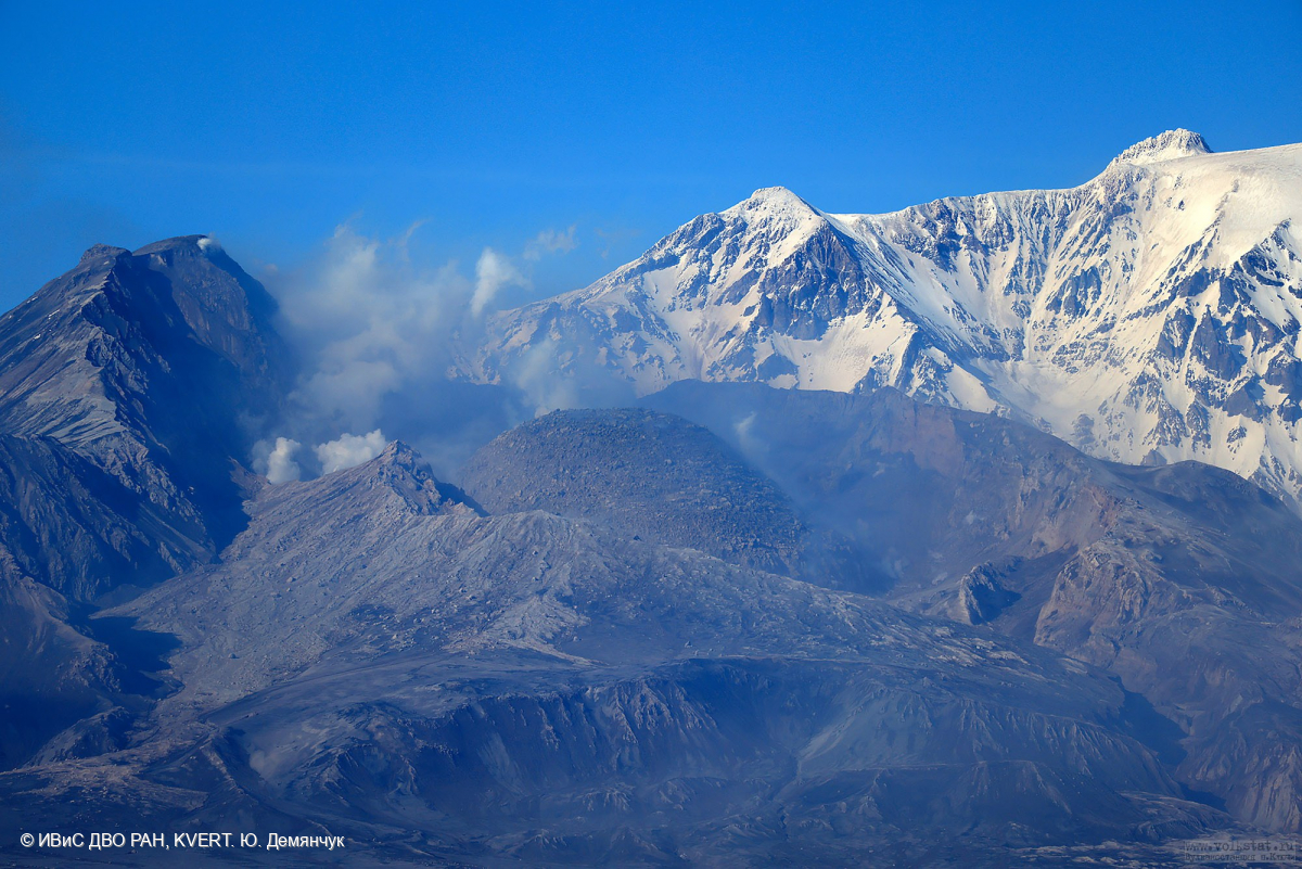
The extrusive-effusive eruption of the volcano continues: a lava is squeezed out in the explosive crater of the Young Sheveluch, it is accompanied by powerful gas-steam activity, and sometimes an incandescence of the lava dome. In the area of the Karan dome, powerful gas-steam activity is also observed, probably associated with the growth of a new lava dome. According to KVERT satellite data, thermal anomalies were observed in the area of the active dome and Karan dome on 16, 18-19, and 22 June, in the other days of the week the volcano was obscured by clouds.
Source : Kvert
Photo : Yu. Demyanchuk, IVS FEB RAS, KVERT
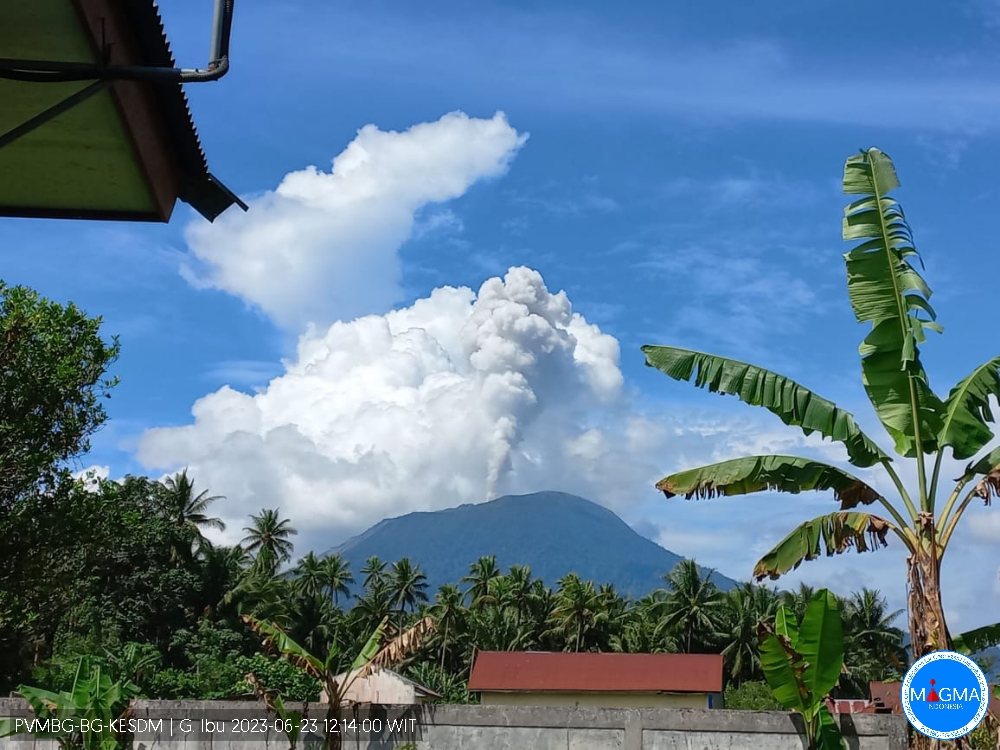
Indonesia , Ibu :
G. Ibu presented an eruption on Friday, June 23, 2023 at 1:37 p.m. WIT with the height of the ash column observed at ± 1000 m above the summit (± 2325 m above sea level). The ash column was observed to be white with a thick intensity, oriented to the northeast. This eruption was recorded on a seismograph with a maximum amplitude of 23 mm and a duration of 99 seconds.
VOLCANO OBSERVATORY NOTICE FOR AVIATION – VONA
Issued : June 23 ,2023
Volcano : Ibu (268030)
Current Aviation Colour Code : ORANGE
Previous Aviation Colour Code : orange
Source : Ibu Volcano Observatory
Notice Number : 2023IBU013
Volcano Location : N 01 deg 29 min 17 sec E 127 deg 37 min 48 sec
Area : North Maluku, Indonesia
Summit Elevation : 4240 FT (1325 M)
Volcanic Activity Summary :
Eruption with volcanic ash cloud at 04h37 UTC (13h37 local).
Volcanic Cloud Height :
Best estimate of ash-cloud top is around 7440 FT (2325 M) above sea level or 3200 FT (1000 M) above summit. May be higher than what can be observed clearly. Source of height data: ground observer.
Other Volcanic Cloud Information :
Ash cloud moving to northeast. Volcanic ash is observed to be white. The intensity of volcanic ash is observed to be thick.
Remarks :
Eruption recorded on seismogram with maximum amplitude 23 mm and maximum duration 99 second.
Source et photo : Magma Indonésie .
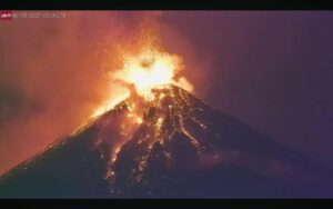
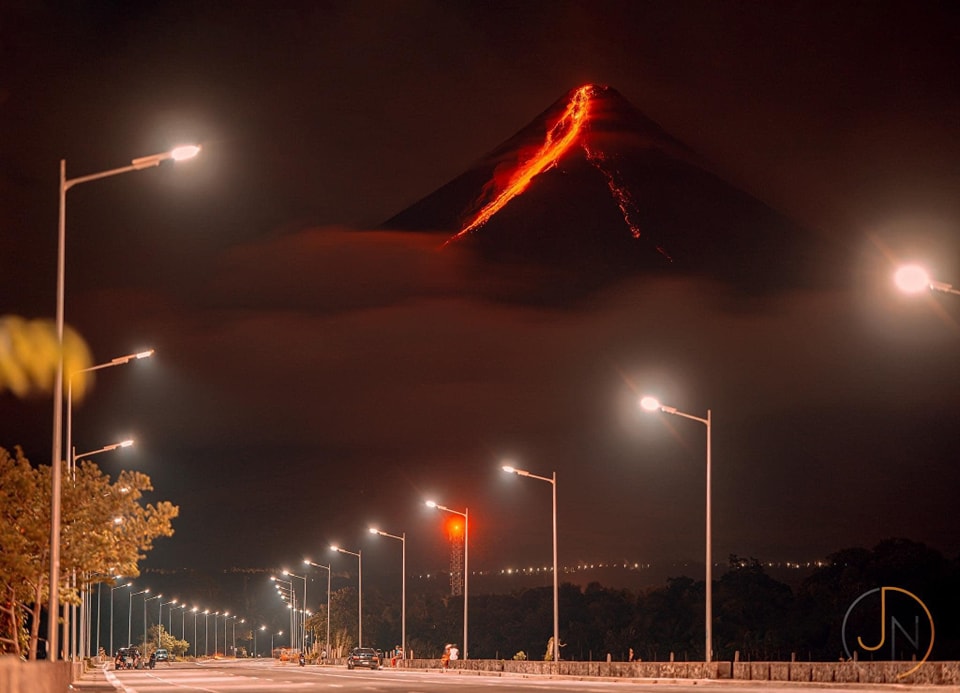
Philippines , Mayon :
MAYON VOLCANO BULLETIN 26 June 2023 8:00 AM
In the past 24-hour period, very slow effusion of lava from the summit crater of Mayon Volcano continued to feed lava flows and collapse debris on the Mi-isi (south) and Bonga (southeastern) gullies. The lava flows have advanced to approximate lengths of one thousand three hundred (1300) meters and one thousand two hundred (1200) meters along Mi-isi and Bonga gullies, respectively, from the summit crater while collapse debris have deposited to three thousand three hundred (3300) meters from the crater. A total of eight (8) dome-collapse pyroclastic density currents (PDC) that lasted three (3) minutes, two hundred sixty-three (263) rockfall events, and one hundred two (102) volcanic earthquakes were recorded by the Mayon Volcano Network
.
Continuous moderate degassing from the summit crater produced steam-laden plumes that rose 100 meters before drifting to the general west direction. Sulfur dioxide (SO2) emission averaged 925 tonnes/day on 25 June 2023. Short-term observations from EDM and electronic tiltmeter monitoring show the upper slopes to be inflating since February 2023. Longer-term ground deformation parameters based on EDM, precise leveling, continuous GPS, and electronic tilt monitoring indicate that Mayon is still inflated, especially on the northwest and southeast.
Alert Level 3 is maintained over Mayon Volcano, which means that it is currently in a relatively high level of unrest as magma is at the crater and hazardous eruption within weeks or even days is possible.
Source : Phivolcs.
Photo : JN.
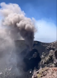
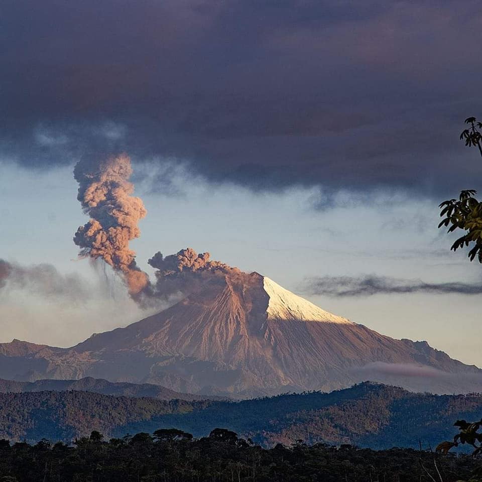
Ecuador , Sangay :
DAILY REPORT OF THE STATE OF SANGAY VOLCANO, Sunday June 25, 2023.
Information Geophysical Institute – EPN.
Surface Activity Level: High, Surface Trend: Ascending
Internal activity level: High, Internal trend: No change
Seismicity: From June 24, 2023, 11:00 a.m. to June 25, 2023, 11:00 a.m.:
Below is the count of seismic events recorded by the reference station over the past 24 hours.
Explosion Event (EXP): 500.
Tremor of emissions (TREMI): 2
Rains / Lahars:
No rain was recorded in areas near the volcano. ** In the event of heavy rains, these could remobilize the accumulated materials, generating mudslides and debris that would descend the flanks of the volcano and pour into the adjacent rivers. **
Emission / Ash Column:
Several columns of gas and ash emission reported by the WVAAC have been recorded, with heights of 866 meters above crater level, in a southwesterly direction.
Gas:
The Mounts satellite system reports 154.5 tons of SO2 on 2023-06-24 at 1:28 p.m. TL.
Other Monitoring Parameters:
The FIRMS satellite system recorded 1 thermal alert and the MIROVA-VIIRS satellite system recorded 1 high thermal alert (363 MW) in the last 24 hours
Observation:
The volcano remained cloudy most of the time.
Alert level: Orange.
Source : IGEPN.
Photo : volcan sangay FB.