June 14 , 2023.
Philippines , Mayon :
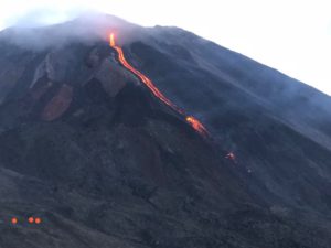
MAYON VOLCANO BULLETIN 14 June 2023 8:00 AM
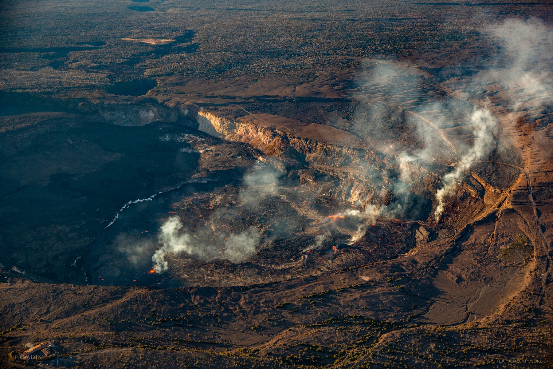
In the past 24-hour period, the Mayon Volcano Network recorded seven (7) volcanic earthquakes and three hundred nine (309) rockfall events based on seismic and visual observations. Very slow effusion of lava from the summit crater emplaced lava flow and collapse debris on the Mi-isi (south) and Bonga (southeastern) gullies within approximately a kilometer from the crater. Seven (7) dome-collapse pyroclastic density current (PDC) that lasted four (4) minutes was also detected via seismic signals and was visually observed.Thin ash from the rockfalls and continuous moderate degassing from the summit crater produced steam-laden plumes that bent and crept downslope before drifting northeast. Fair crater glow and incandescent rockfall shed from new fluidal lava at the summit of Mayon Volcano was observed. Sulfur dioxide (SO2) emission averaged 723 tonnes/day on 12 June 2023. Short-term observations from EDM and electronic tiltmeter monitoring show the upper slopes to be inflating since February 2023. Longer-term ground deformation parameters based on EDM, precise leveling, continuous GPS, and electronic tilt monitoring indicate that Mayon is still inflated, especially on the northwest and southeast.
Alert Level 3 is maintained over Mayon Volcano, which means that it is currently in a relatively high level of unrest as magma is at the crater and hazardous eruption is possible within weeks or even days. It is therefore recommended that the 6-km radius Permanent Danger Zone (PDZ) be evacuated due to the danger of PDCs, lava flows, rockfalls and other volcanic hazards. Increased vigilance against pyroclastic density currents, lahars and sediment-laden streamflows along channels draining the edifice is also advised. Heavy rainfall could generate channel-confined lahars and sediment-laden streamflows in channels where PDC deposits were emplaced. Civil aviation authorities must also advise pilots to avoid flying close to the volcano’s summit as ash from any sudden eruption can be hazardous to aircraft. Based on the current prevailing wind pattern, ash fall events may most likely occur on the south side of the volcano.
DOST-PHIVOLCS maintains close monitoring of Mayon Volcano and any new development will be communicated to all concerned stakeholders.
Source : Phivolcs.
Photo : Alfredo Ali Vicoy
Hawaii , Kilauea :
Tuesday, June 13, 2023, 9:11 AM HST (Tuesday, June 13, 2023, 19:11 UTC)
19°25’16 » N 155°17’13 » W,
Summit Elevation 4091 ft (1247 m)
Current Volcano Alert Level: WATCH
Current Aviation Color Code: ORANGE
Activity Summary:
Kīlauea volcano is erupting. Eruptive activity is confined to Halemaʻumaʻu crater within Kīlauea’s summit caldera. No unusual activity has been noted along Kīlauea’s East Rift Zone or Southwest Rift Zone.
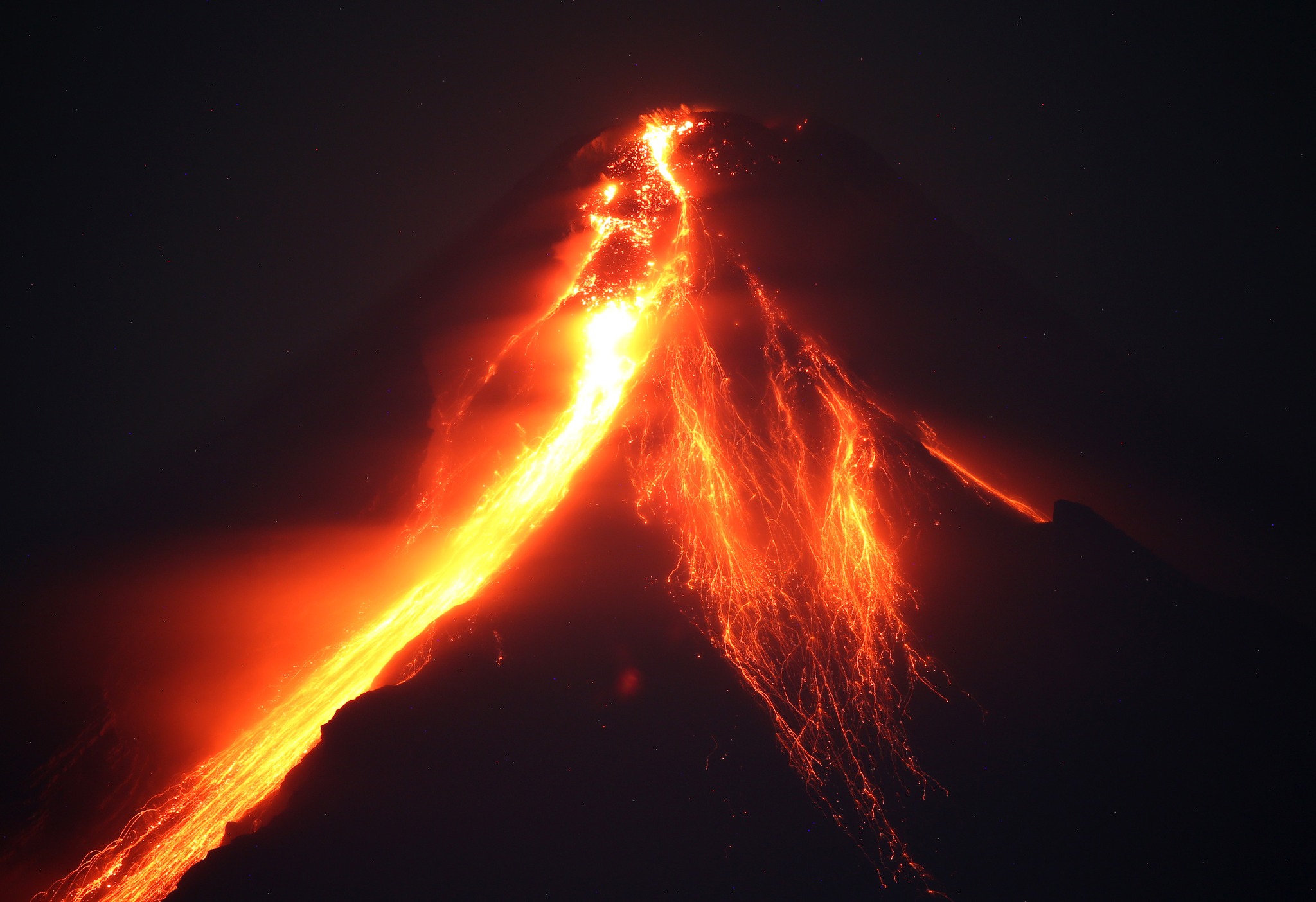
Halemaʻumaʻu Lava Lake Observations:
Activity continues to decrease. Fountaining is diminished on the southwestern Halemaʻumaʻu crater floor, with only a few small fountains remaining. The extent of active lava has retreated further such that all activity is now concentrated in the southwestern and central portions of Halemaʻumaʻu Crater. An active lava lake is centered within the central area and is fed by a vent in its northeast corner. This feature is the « western » lake from prior eruptions that has been reactivated along with a smaller circular pool just southeast of the lake. The vent on the southwest wall of the caldera continues to spatter and feed lava onto the westernmost part of the crater floor. The surface of the western active area has not risen since yesterday. All previously active lava features in the northern and eastern portions of the crater now appear to be stagnant.
Summit Observations:
Summit tilt switched from ongoing deflation to mild inflation as of early yesterday afternoon. Summit seismic activity is dominated by eruptive tremor (a signal associated with fluid movement). Volcanic gas emissions in the area remain elevated; a sulfur dioxide (SO2) emission rate of approximately 7,400 tonnes per day was measured on Sunday, June 11, 2023.
Rift Zone Observations:
No unusual activity has been noted along the East Rift Zone or Southwest Rift Zone; steady but low rates of ground deformation and seismicity continue along both. Measurements from continuous gas monitoring stations in the middle East Rift Zone—the site of 1983–2018 eruptive activity—remain below detection limits for SO2.
Source : HVO
Photo : Bruce Omori
Italy / Sicily , Etna :
WEEKLY BULLETIN, from June 05, 2023 to June 11, 2023. (issue date June 13, 2023)
ACTIVITY STATUS SUMMARY
In the light of the monitoring data, it is highlighted:
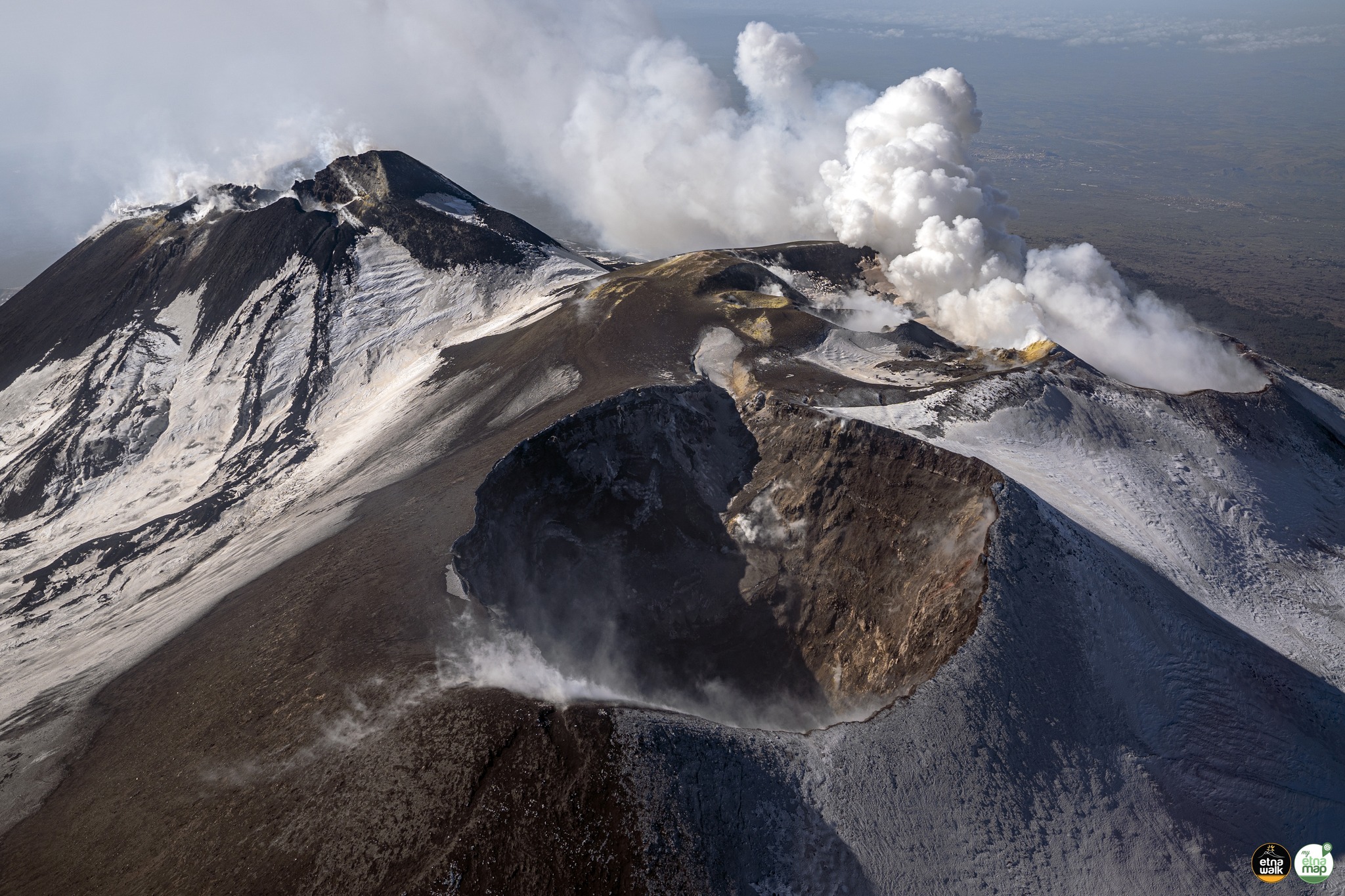
1) VOLCANOLOGICAL OBSERVATIONS: Degassing activity at the summit craters, in particular continuous degassing at the Bocca Nuova crater (BN) and at the Southeast crater (CSE).
2) SEISMOLOGY: Absence of seismic activity of fracturing with Ml>=2.0; average amplitude of the volcanic tremor in the average level.
3) INFRASOUND: Moderate rate of occurrence of events during the first four days of the week.
The events were mainly located in the Bocca Nuova crater area and subordinate to the Southeast crater.
4) GROUND DEFORMATIONS: Over the past week, ground deformation monitoring networks have recorded modest inflation at the middle elevations of the volcano
5) GEOCHEMISTRY: SO2 flux at medium-low level
The CO2 fluxes show an upward trend settling on medium-high degassing values.
There are no updates on the Helium isotope ratio.
The partial pressure of dissolved CO2 does not show any significant variations.
6) SATELLITE OBSERVATIONS: Thermal activity observed from the satellite was generally weak.
VOLCANOLOGICAL OBSERVATIONS
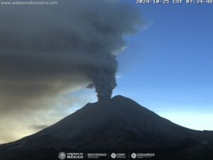
During the week, monitoring of Etna’s activity was carried out through the surveillance cameras of the INGV – Osservatorio Etneo. Throughout the period, observations were discontinued due to the conspicuous cloud cover, which shrouded the summit area daily in the morning, only to dissipate in the evening.
During the week, the degassing of the summit craters continued, without notable variations, in particular from the Bocca Nuova crater and from the eastern mouth of the Southeast Crater. Weak vapor emissions from the Voragine crater and the Northeast crater were observed only under conditions of high atmospheric humidity.
SEISMOLOGY
Seismicity: During the week in question, no earthquake located in the Etna area reached or exceeded the magnitude 2.0 threshold.
Volcanic tremor: The average amplitude of volcanic tremor remained within the range of average values, generally with a stable trend. The locations of the centroids of volcanic tremor sources concerned a volume located in correspondence with the Southeast Crater, in a depth range mainly between 2500 and 2800 m above mean sea level.
Source : INGV.
Photo : Giuseppe Distefano
Kamchatka , Sheveluch :
VOLCANO OBSERVATORY NOTICE FOR AVIATION (VONA)
Issued: June 13 , 2023.
Volcano: Sheveluch (CAVW #300270)
Current aviation colour code: ORANGE
Previous aviation colour code: orange
Source: KVERT
Notice Number: 2023-76
Volcano Location: N 56 deg 38 min E 161 deg 18 min
Area: Kamchatka, Russia
Summit Elevation: 3283 m (10768.24 ft), the dome elevation ~2500 m (8200 ft)
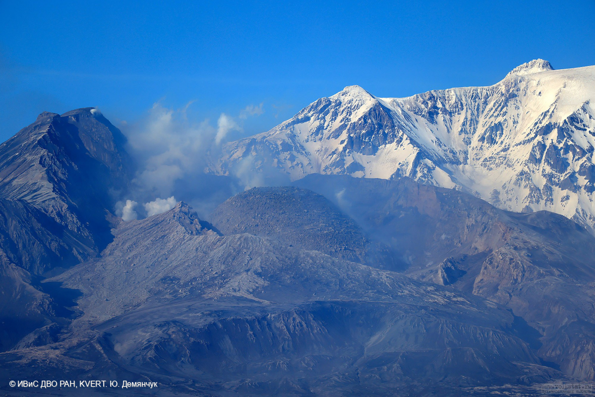
The growth of the lava dome in the explosion crater formed on April 10-13, 2023 continues. Plastic lava covers the slopes of the dome with lava flows.
Volcanic Activity Summary:
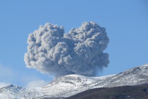
The extrusive-effusive eruption of the volcano continues. Video data by KVERT shows plume of resuspended ash extends more 60 km to the east of the volcano.
An extrusive eruption of the volcano continues. A danger of ash explosions up to 10 km (32,800 ft) a.s.l. is remains. Ongoing activity could affect international and low-flying aircraft.
Volcanic cloud height:
3500 m (11480 ft) AMSL Time and method of ash plume/cloud height determination: 20230613/2120Z – Video data
Other volcanic cloud information:
Distance of ash plume/cloud of the volcano: 60 km (37 mi)
Direction of drift of ash plume/cloud of the volcano: E
Time and method of ash plume/cloud determination: 20230613/2120Z – Video data
Source : Kvert
Photo : Yu. Demyanchuk
Chile , Hudson :
Special Report on Volcanic Activity (REAV), Aysen Del General Carlos Ibanez Del Campo area, Hudson volcano, June 10, 2023, 7:42 p.m. local time (mainland Chile).
The National Service of Geology and Mines of Chile (Sernageomin) publishes the following PRELIMINARY information, obtained through the monitoring equipment of the National Volcanic Monitoring Network (RNVV), processed and analyzed at the Volcanological Observatory of the Southern Andes ( Ovdas):
On Saturday June 10, 2023, at 7:22 p.m. local time (23:22 UTC), the monitoring stations installed near the Hudson volcano recorded an earthquake associated with both rock fracturing (volcano-tectonic type) and fluid dynamics in the volcanic system (hybrid type).
The characteristics of earthquakes after their analysis are as follows:
ORIGINAL TIME: 7:22 p.m. local time (23:22 UTC)
LATITUDE: 45.905°S
LONGITUDE: 72.942° E
LOCAL MAGNITUDE: 2.7
REDUCED DISPLAY: 1317 cm2
DEPTH: 4.1km
COMMENTS:
Following the event, 5 other similar events were recorded, but of lower energy.
The volcanic technical alert remains at the Green level.
Sources : Sernageomin.
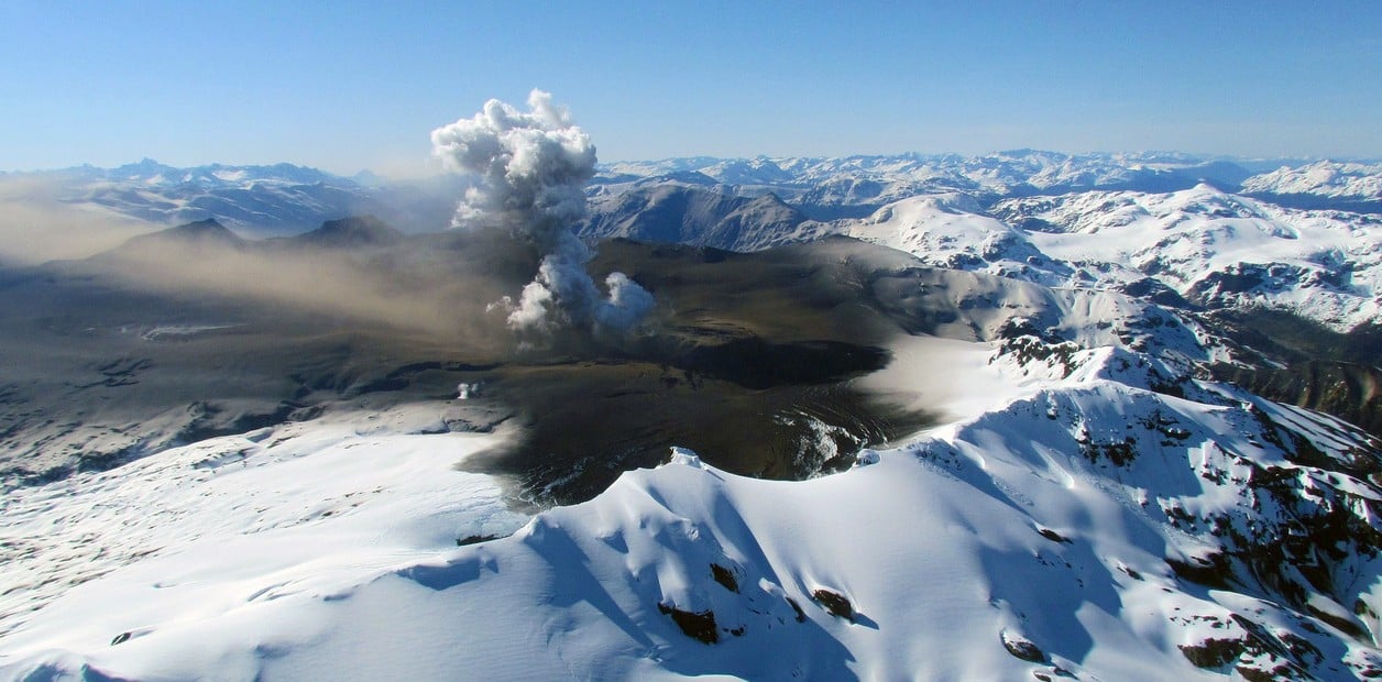
Photo : Clarin.