Juin 2023.
Hawaii , Kilauea :
Friday, June 9, 2023, 8:55 AM HST (Friday, June 9, 2023, 18:55 UTC)
19°25’16 » N 155°17’13 » W,
Summit Elevation 4091 ft (1247 m)
Current Volcano Alert Level: WATCH
Current Aviation Color Code: ORANGE
Activity Summary:
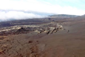
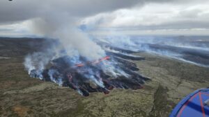
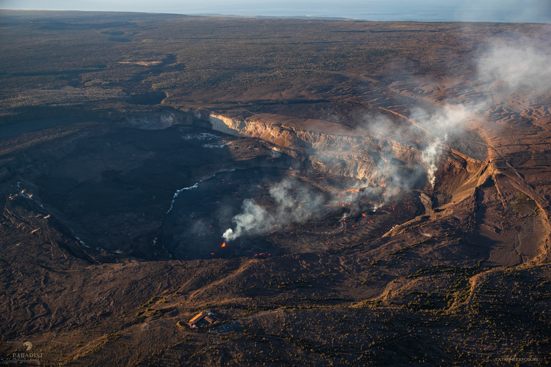
Kīlauea volcano is erupting. Eruptive activity is confined to Halemaʻumaʻu crater within Kīlauea’s summit caldera. No unusual activity has been noted along Kīlauea’s East Rift Zone or Southwest Rift Zone.
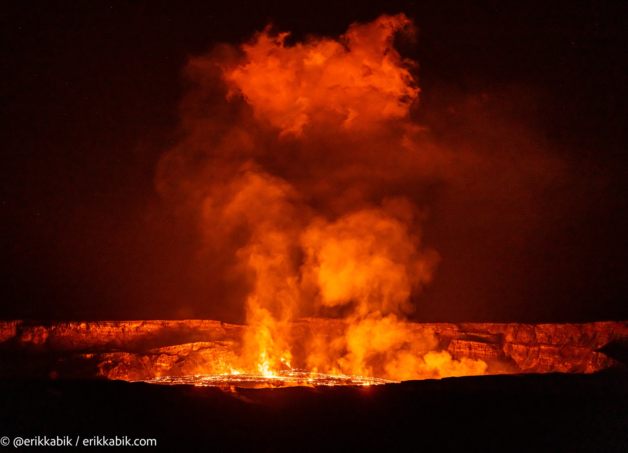
Halemaʻumaʻu crater Lava Lake Observations:
Multiple minor fountains remain active on the western Halema‘uma‘u crater floor and the vent on the southwest wall of the caldera continues to feed lava onto the westernmost part of the crater floor. Lava fountain heights have decreased since the eruption onset, but remain up to about 10 meters (33 feet) high. Active lava and vents cover much of the west half of Halemaʻumaʻu crater in a broad horseshoe around a central uplifted area. An active lava lake is centered within the uplifted area and is fed by a vent in its northeast corner. This feature is the « western lava lake » from prior eruptions that has been reactivated along with a smaller circular pool just southeast of the lake. A much smaller area of lava also remained active in the eastern portion of the crater floor over night. Over the past 24 hours, the level of the central lava lake has increased by approximately 1.5 meters (5 feet), as measured by laser rangefinder
Summit Observations:
Summit tilt has remained deflationary over the past 24 hours. Summit seismic activity is dominated by eruptive tremor (a signal associated with fluid movement) resumed. Volcanic gas emissions in the eruption area are elevated; a sulfur dioxide (SO2) emission rate of approximately 21,000 tonnes per day was measured yesterday, June 8, 2023.
Rift Zone Observations:
No unusual activity has been noted along the East Rift Zone or Southwest Rift Zone; steady rates of ground deformation and seismicity continue along both. Measurements from continuous gas monitoring stations in the middle East Rift Zone—the site of 1983–2018 eruptive activity—remain below detection limits for SO2.
Source : HVO
Photo : Erik Kabik , Bruce Omori .
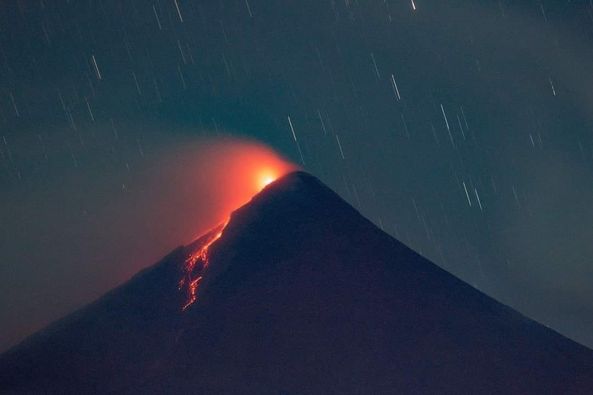
Philippines , Mayon :
MAYON VOLCANO BULLETIN 10 June 2023 8:00 AM
In the past 24-hour period, the Mayon Volcano Network recorded recorded one (1) volcanic earthquake and fifty-nine (59) rockfall events based on seismic and visual observations. The rockfall events emplaced lava debris on the south and southeastern gullies within one thousand five hundred (1500) meters from the summit crater. Thin ash from the rockfalls and continuous moderate degassing from the summit crater produced steam-laden plumes that were bent and crept downslope before drifting to the general southeast. Fair crater glow or “banaag” and incandescent rockfall shed from new fluidal lava at the summit of Mayon Volcano was also observed last night. Sulfur dioxide (SO2) emission was last measured at an average of 417 tonnes/day on 09 June 2023. Short-term observations from EDM and electronic tiltmeter monitoring show the upper slopes to be inflating since February 2023. Longer-term ground deformation parameters based on EDM, precise leveling, continuous GPS, and electronic tilt monitoring indicate that Mayon is still inflated, especially on the northwest and southeast.
Alert Level 3 is now raised over Mayon Volcano, which means that it is currently in a relatively high level of unrest as magma is at the crater and hazardous eruption is possible within weeks or even days. It is therefore recommended that the 6-km radius Permanent Danger Zone (PDZ) be evacuated due to the danger of PDCs, lava flows, rockfalls and other volcanic hazards. Increased vigilance against pyroclastic density currents, lahars and sediment-laden streamflows along channels draining the edifice is also advised. Heavy rainfall could generate channel-confined lahars and sediment-laden streamflows in channels where PDC deposits were emplaced. Civil aviation authorities must also advise pilots to avoid flying close to the volcano’s summit as ash from any sudden eruption can be hazardous to aircraft. Based on the current prevailing wind pattern, ash fall events may most likely occur on the south side of the volcano.
DOST-PHIVOLCS maintains close monitoring of Mayon Volcano and any new development will be communicated to all concerned stakeholders.
Source : Phivolcs
Photo : James Albert Polero
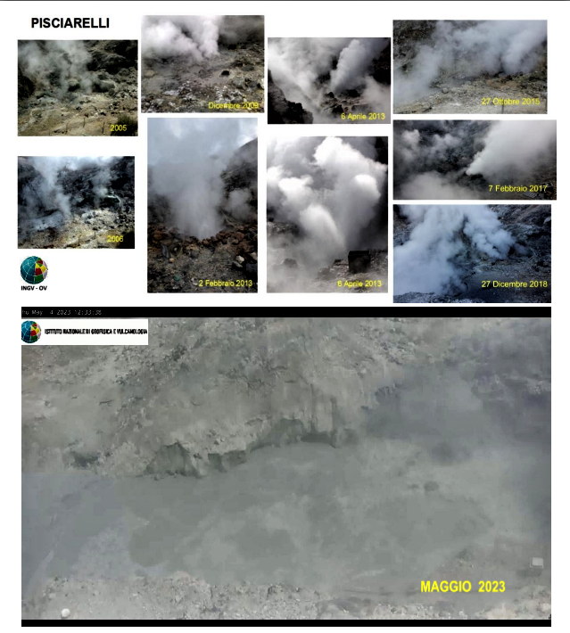
Italy , Campi Flegrei :
SUMMARY OF THE STATE OF THE VOLCANO IN APRIL 2023 AND ASSESSMENTS.
1) SEISMOLOGY: 661 earthquakes (Mdmax=3.59±0.3) were recorded in the Campi Flegrei area, of which 311 were localized, which occurred mainly between Pozzuoli, Bagnoli, the Solfatara-Pisciarelli area and the Gulf of Pozzuoli, with depths concentrated in the first 2 km and maximum depth of around 4.5 km.
2) DEFORMATIONS: The average value of the lifting speed in the maximum deformation zone is about 15±3 mm/month. The uplift recorded at the RITE GPS station is about 108 cm since November 2005, including about 76 cm since January 2016.
The variations on the tilt meters are consistent with the uplift phase affecting the area.
There are no significant variations in severity and tension.
3) THERMOGRAPHY: The maximum values of the surface temperature IR time series of the Pisciarelli and Solfatara zone, although characterized by oscillations (more sensitive at the SF2 station), are substantially stable. The area of via Antiniana shows a slight decrease in maximum temperature values.
Measurements with mobile thermal cameras carried out at different points in the Campi Flegrei show stable trends.
4) GEOCHEMISTRY: The composition of the fumaroles and the parameters monitored indicate the continuation of the multi-year trends of heating and pressurization of the hydrothermal system which reached a maximum in July 2020, then reversed until the first months of 2022, where a new upward trend has started until September 2022. The samples of the last months do not show a well-defined trend. The more reducing character of the gaseous emissions, observed in recent months, is probably due to the processes of condensation of the steam in response to the increase in pressure of the hydrothermal system. The CO2/CH4 ratio shows a slight increase in values compared to previous periods, suggesting the start of a new upward trend.
The estimated flux of CO2 released from the ground for the entire Solfatara area is around 3000 t/d.
Based on the current framework of volcanic activity outlined above, there is no evidence to suggest significant short-term developments.
N.B. Any variation in the monitored parameters may lead to a different evolution of the danger scenarios described above.
Surveillance of the Phlegraean zone remains at the « Warning » level.
Source et photo : INGV
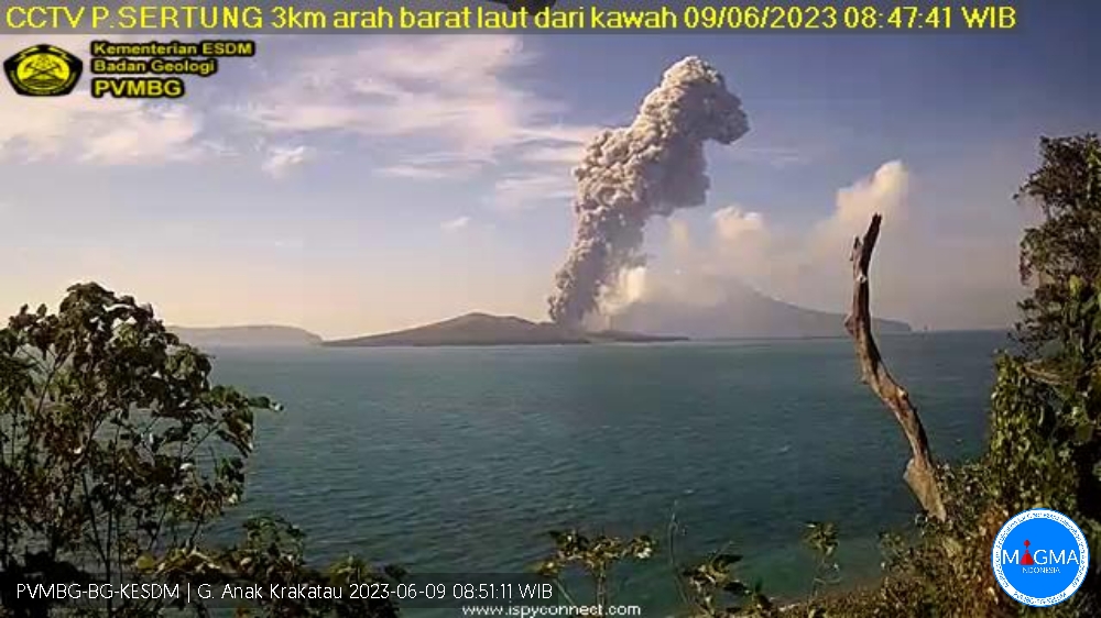
Indonesia , Anak Krakatau :
An eruption of Mount Anak Krakatau occurred on Saturday June 10, 2023 at 04:23 WIB with the height of the ash column observed at ± 2000 m above the summit (± 2157 m above sea level). The ash column was observed to be gray with a thick intensity, oriented northwest. This eruption was recorded on a seismograph with a maximum amplitude of 60 mm and a duration of 240 seconds.
VOLCANO OBSERVATORY NOTICE FOR AVIATION – VONA
Issued : June 09 , 2023
Volcano : Anak Krakatau (262000)
Current Aviation Colour Code : ORANGE
Previous Aviation Colour Code : orange
Source : Anak Krakatau Volcano Observatory
Notice Number : 2023KRA057
Volcano Location : S 06 deg 06 min 07 sec E 105 deg 25 min 23 sec
Area : Lampung, Indonesia
Summit Elevation : 502 FT (157 M)
Volcanic Activity Summary :
Eruption with volcanic ash cloud at 21h23 UTC (04h23 local).
Volcanic Cloud Height :
Best estimate of ash-cloud top is around 6902 FT (2157 M) above sea level or 6400 FT (2000 M) above summit. May be higher than what can be observed clearly. Source of height data: ground observer.
Other Volcanic Cloud Information :
Ash cloud moving to northwest. Volcanic ash is observed to be gray. The intensity of volcanic ash is observed to be thick.
Remarks :
Eruption recorded on seismogram with maximum amplitude 60 mm and maximum duration 240 second
Source et photo : Magma Indonésie.
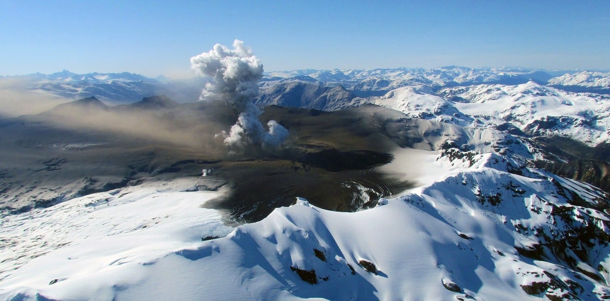
Chile , Hudson :
Seismology
The seismological activity of the period was characterized by the recording of:
37 VT-type seismic events, associated with rock fracturing (Volcano-Tectonics). The most energetic earthquake presented a value of local magnitude (ML) equal to 1.1, located 7.7 km to the South-South-East and with a depth of 4.6 km from the center of the caldera.
97 LP-type seismic events, associated with fluid dynamics within the volcanic system (Long Period). The size of the largest earthquake assessed from the Reduced Displacement (DR) parameter was equal to 30 cm2.
2 seismic events of the TR type, associated with the dynamics maintained over time of the fluids within the volcanic system (TRemor). The size of the largest earthquake assessed from the Reduced Displacement (DR) parameter was equal to 18 cm2.
3 HB-type seismic events, associated with both rock fracturing and fluid dynamics within the volcanic system (hybrid). The most energetic earthquake presented a reduced displacement value (DR) of 43 cm2 and a local magnitude value (ML) equal to 0.6, located 3.2 km to the North-North-West and with a depth of 9.7 km from the center of the caldera.
Fluid Geochemistry
No anomalies of sulfur dioxide (SO2) emissions in the atmosphere have been reported in the area near the volcano, according to data published by the Tropospheric Monitoring Instrument (TROPOMI) and the Ozone Monitoring Instrument (OMI).
Satellite thermal anomalies
During the period, no thermal alert was recorded in the area associated with the volcanic complex, according to the data processed by the observation of volcanic activity in the mid-infrared (MIROVA) and by the analytical processing of the images. Sentinel 2-L2A satellite, in combination of false color bands.
Geodesy
According to data provided by 2 GNSS stations that monitor the deformation of the volcano, low rates of displacement are observed, with magnitudes less than 0.2 cm / month.
Surveillance cameras
The images provided by the fixed camera, installed near the volcanic system, did not record degassing columns or variations related to surface activity.
Activity showed a decrease to levels considered low, suggesting stability of the volcanic system.
The volcanic technical alert is maintained at: GREEN TECHNICAL ALERT: Active volcano with stable behavior – There is no immediate risk
Source : Sernageomin
Photo : clarin