April 28 ,2023.
After a very dark notebook, the Cauldron is back.
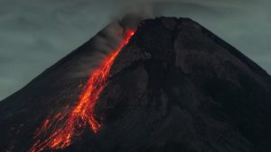
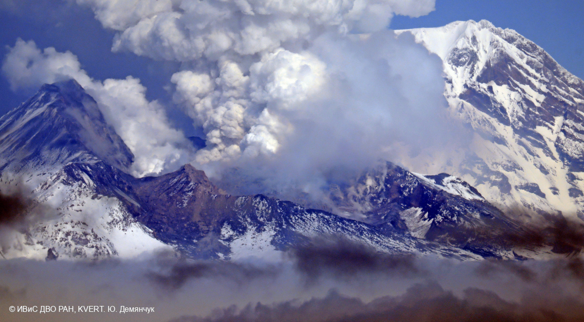
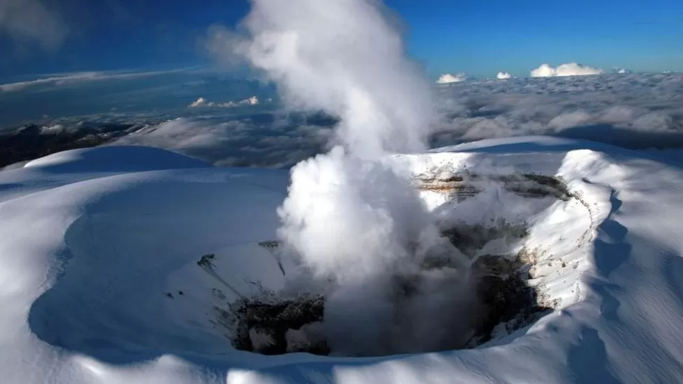
Kamchatka , Sheveluch :
56.64 N, 161.32 E;
Elevation 3283 m (10768 ft),
the dome elevation ~2500 m (8200 ft)
Aviation Colour Code is ORANGE
An extrusive eruption of the volcano continues. A danger of ash explosions up to 10 km (32,800 ft) a.s.l. is remains. Ongoing activity could affect international and low-flying aircraft.
A growth of the lava dome continues, a strong fumarole activity, an incandescence of the lava dome, and sometimes explosions accompanies this process. According to KVERT data, the paroxysmal eruption continued on 10-13 April, ash and aerosol clouds moved more than 3,000 km east of the volcano, but to date on 21 April, the aerosol cloud is located in the middle part of the Greenland Island.
The result of the paroxysmal explosive eruption of the Sheveluch volcano on 10-13 April, 2023: a large crater in place of the lava dome that has been forming since 1980.
On 14-15 April, ash removal up to 6 km a.s.l. from the volcano continued, ash plumes moved for 700 km to the northwest of the volcano. On 17 April, resuspended ash lifted by the wind from the slopes of Sheveluch volcano and volcanoes of the Klyuchevskaya group (ashes of Sheveluch volcano deposited on 10-13 April) rose up to 4 km a.s.l. Plumes of resuspended ash extended for 224 km northwest of the volcano. A thermal anomaly was observed over the volcano all week.
Source : Kvert.
Photo : Yu. Demyanchuk. IVS FEB RAS, KVERT
Colombia , Nevado del Ruiz :
Manizales, April 27, 2023, 9:50 a.m.
Regarding the monitoring of the activity of the NEVADO DEL RUIZ VOLCANO, the MINISTRY OF MINES AND ENERGY through the COLOMBIAN GEOLOGICAL SERVICE (SGC) informs that:
Yesterday April 26, the seismic activity associated with the fracturing of the rock inside the volcanic edifice increased compared to the day before (April 25). The earthquakes were located mainly in the northeast and east sectors of the volcano, at depths between 2 and 3.5 km. The maximum magnitude was 1.4 corresponding to the 9:48 p.m. earthquake, located 0.9 km northeast of the crater, at a depth of about 3 km. Regarding the seismic activity related to the movement of fluids inside the volcanic conduits, it showed similar levels of seismic energy, compared to the day before and was associated with pulsatile ash emissions which were confirmed by web cameras used for volcanic monitoring.
The maximum height of the column of gas and / or ash observed was 1800 m measured from the summit of the volcano corresponding to the emission of ash recorded yesterday at 03:14, with the direction of dispersion of the column towards the South-West. Significant thermal anomalies continue at the bottom of the crater, which could be observed from satellite monitoring platforms, as well as the degassing of sulfur dioxide in the atmosphere and the release of water vapor from the volcano.
All these indicators ratify what the SGC has reiterated: that the activity of the Nevado del Ruiz volcano continues to be very unstable. It is possible that the levels of seismic activity, as well as the levels of degassing or ash production, decrease or oscillate, in the direction of increasing on some days and decreasing on others. However, this does not mean that the volcano has returned to its normal level of activity.
Therefore, we reaffirm that the activity of the Nevado del Ruiz volcano continues at the ORANGE LEVEL.
Source et photo : SGC.
La Réunion , Piton de la Fournaise :
Press release from the Paris Institute of Earth Physics, Piton de la Fournaise Volcanological Observatory, April 24, 2023 – 08:30 (local time) – 04:30 (UTC time)
Following the seismic crisis of April 21, seismicity is still recorded under the summit zone of Piton de La Fournaise, with respectively 7 and 14 volcano-tectonic earthquakes under the summit zone for the days of April 22 and 23, 2023.
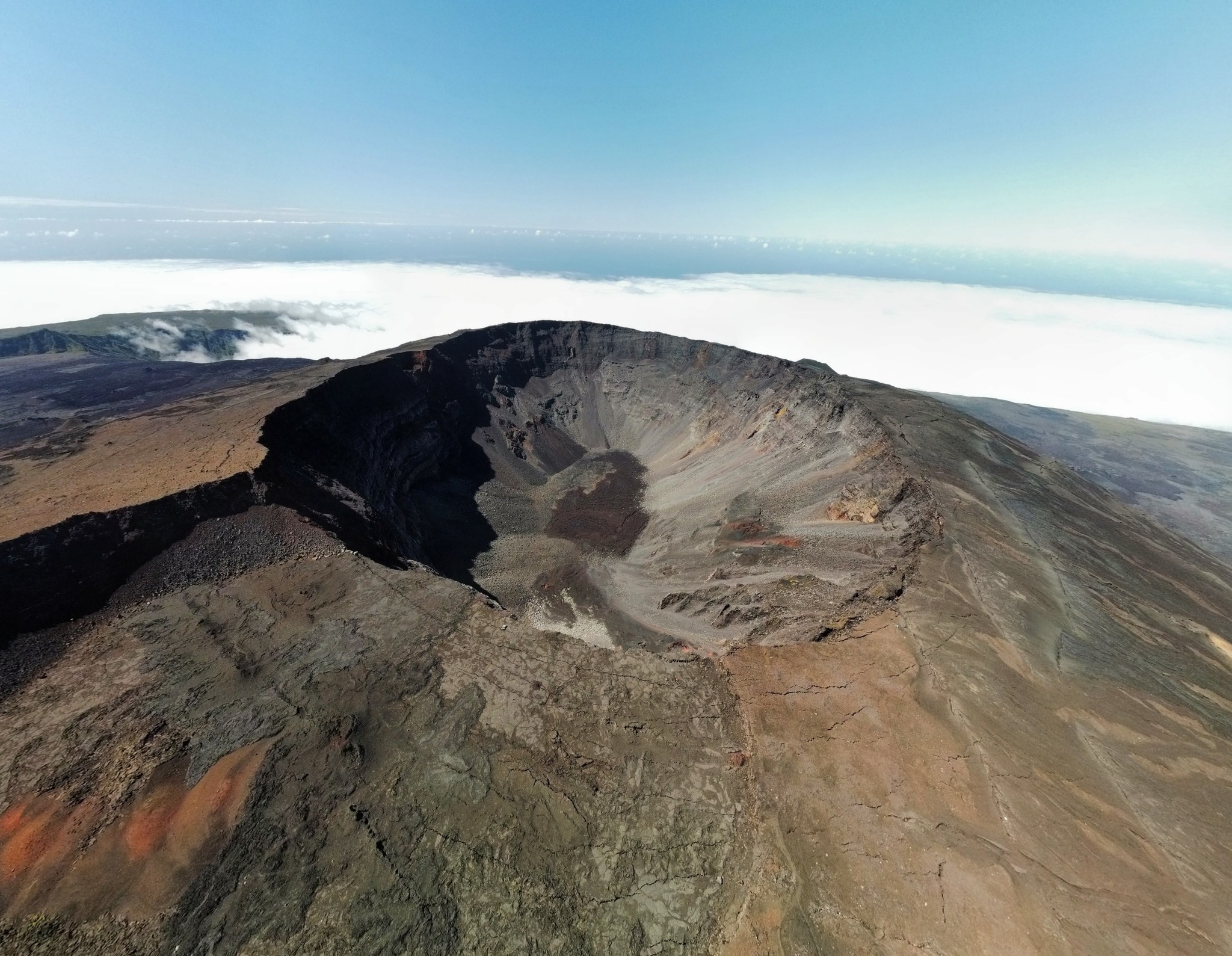
At the same time, the inflation (swelling) of the volcano, observed for several weeks, continues. This testifies to the continued replenishment of the superficial reservoir (located 1.5-2 km deep) by deeper magma. But since the cessation of the seismic crisis and the cessation of deep magma intrusion on April 21, no movement of magma from this reservoir
towards the surface is not to be noted.
The recharge process from the depths to the superficial reservoir can take several days to several weeks before the roof of the reservoir weakens again and ruptures, thus giving rise to a new injection of magma towards the surface, but can also stop without giving rise to an eruption in the short term.
Recommended alert level: Vigilance
Source : direction de l’OVPF-IPGP
Photo : Tunnels de lave Réunion : Rando-Volcan
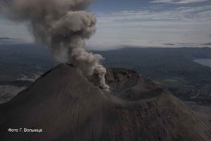
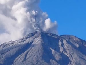
Italy , Stromboli :
WEEKLY BULLETIN, from April 18, 2023 to April 24, 2023. (issue date 26 April 2023)
ACTIVITY STATUS SUMMARY
In the light of the monitoring data, it is highlighted:
1) VOLCANOLOGICAL OBSERVATIONS: Normal Strombolian activity was observed during this period. The total hourly frequency oscillated between low average values (8 events/h) and medium-high values (16 events/h). The intensity of the explosions was mainly low to medium in both the North Crater area and the Center-South Crater area.
2) SEISMOLOGY: The seismological parameters monitored do not show any significant variations.
3) GROUND DEFORMATIONS: The island’s ground deformation monitoring networks did not show any relevant variations during the week under review. Exclusively, the inclinometer station of Timpone del Fuoco recorded on April 23 a variation of less than one microradian.
4) GEOCHEMISTRY: the flow of SO2 is at an average level
The CO2 streams show average degassing values.
The C/S ratio is on very high values around 21.
The isotopic ratio of the helium dissolved in the thermal wells is at average values with an R/Ra equal to 4.3 (last sampled on 03/17/2023).
5) SATELLITE OBSERVATIONS: The thermal activity observed from the satellite was generally weak.

VOLCANOLOGICAL OBSERVATIONS
During the observation period, the eruptive activity of Stromboli was characterized thanks to the analysis of the images recorded by the surveillance cameras of the INGV-OE at an altitude of 190m (SCT-SCV) and of the Pizzo . The explosive activity was mainly produced by 2 (two) eruptive vents located in the North zone of the crater and by 3 (three) vents located in the Center-South zone. Due to the unfavorable weather conditions of April 17 and 18, the visibility of the crater area was insufficient for a correct description of the eruptive activity.
Observations of explosive activity captured by surveillance cameras
In the area of the North crater (N), with a vent located in the N1 sector and one in the N2 sector, an explosive activity of low intensity (less than 80 m in height) to medium intensity (less than 150 m in height) was observed emitting coarse materials (bombs and lapilli) sometimes mixed with fine materials (ash). The average frequency of explosions varied from 2 to 9 events/h.
In the Center-South (CS) area, the S2 sector, with two active vents, showed explosive activity of mainly low to medium intensity emitting fine materials sometimes mixed with coarse materials. Sector C and sector S1 did not show significant eruptive activity. The average frequency of explosions varies between 2 and 7 events/h.
Field observations following the site visits of April 21 and 22, 2023
On April 21, researchers from the INGV-OE in Catania carried out an inspection in the summit area of Stromboli, during which the explosive activity and the morphology of the craters were observed (Fig. 3.3 a), samples fresh lapilli were collected and some data collection stations were maintained.
In the N zone of the crater there was, near the N1 zone, what remains of a small cone with at least 2 active vents, one of which emitted Strombolian explosions rich in shreds of magma, while the other vent produced explosions of ash mixed with small amounts of shreds of magma. At least one vent with violent and frequent ash emissions was active in the N2 area. In the central area there was a small cone with 2-3 degassing vents in an almost central position, and a smaller and probably cracked area, also degassed and more displaced towards the Pizzo (and therefore partly covered by the edge of the crater), which during our observations did not deliver any products.
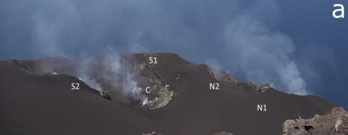
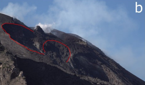
Overview of the crater terrace seen from the Pizzo with the names of the sectors. b) Photo of the N crater area seen from the altitude of 400m. In red the boundaries of the two detachment niches
In the South zone, there was, from the North-East to the South-West, a small hornito characterized by modest and rare explosions, a vent which produced weak Strombolian explosions with a very variable but always low frequency, and a vent at the edge of the terrace with frequent ash emissions. From the southern area of the crater came very violent jets of gas apparently not associated with the emission of products. Finally, at vent S1, a hornito was present which emitted a generally weak degassing, sometimes associated with “smoke rings”. Due to the unfavorable wind direction, it was not possible to sample the products of the observed activity, however very fresh subcentimetric lapilli were sampled on the way between Elipista and the Pizzo, probably correlated to the activity from April 17-18 when the weather also favored the fall of ashes in the municipality of Stromboli.
Finally, on Saturday morning April 22, an inspection was carried out at 400 m (Labronzo side) to observe the morphology of the Sciara del Fuoco, where 2 large « detachment niches/slip surfaces » were evident under the N zone of the crater (Fig. 3.3 b, boundaries in red), while frequent rollings of blocks towards the sea were observed along the « canyon », both immediately after the explosions and in periods when there was no explosive activity.
Source : INGV.
Photos : Stromboli stati d’animo , INGV.
Costa Rica , Rincon de la Vieja :
Latitude: 10.83
Longitude:-85.324
Altitude: 1,916 meters
Observed activity:
The activity of the volcano continues with frequent eruptions. The last occurred at 5:28 am and produced a column of water vapor up to 800m above the crater. Seismicity shows a continuous tremor of low frequency and high amplitude.
Environmental conditions:
westerly winds; clear weather
Activity Level: Warning (2)
OVSICORI-UNA reported that phreatic eruptions, detected seismically but often with observed emissions, continued to occur at Rincón de la Vieja during 18-25 April. Several eruptive events recorded during 18-21 April produced gas-and-steam emissions that rose as high as 1.5 km above the crater rim. A strong eruptive event at 1550 on 21 April generated a dense plume of material that rose 500 m above the crater rim and then collapsed, producing a pyroclastic flow and lahars on the N flank. A steam-and-gas plume with minor ash content rose 4-5 km above the crater rim. Strong tremor levels and near-continuous gas emissions were recorded after the event. That same day OVSICORI-UNA noted that during the previous week sulfur dioxide emissions were 221 tons per day on average, though emissions spiked to close to 5,000 tons per day after several of the phreatic events. During 22-24 April nearly continuous gas emissions continued to be visible and strong tremor continued to be recorded by the seismic network. Small phreatic events were recorded at 19h04 on 22 April and at 00h54 and 06h29 on 24 April. Small phreatic events at 22h50 on 23 April and 06h30 on 24 April produced steam-and-gas plumes that rose no higher than 500 m above the crater rim.
Source : GVP , Observatorio Vulcanologico y Sismologico de Costa Rica-Universidad Nacional (OVSICORI-UNA).
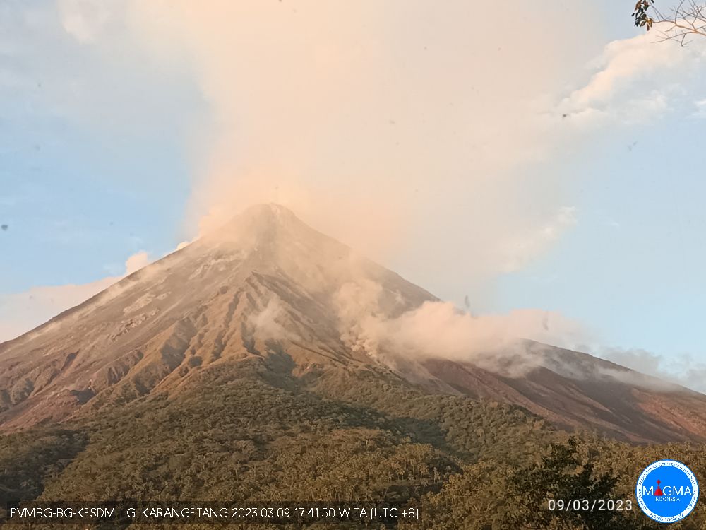
Indonesia , Karangetang :
Decrease in Karangetang activity level from level III (SIAGA) to level II (WASPADA)
Visual observation
White smoke from the crater is observed with low to moderate intensity, the maximum height of the smoke column reaches 200 m above the summit. Effusive eruptions were observed until April 1, 2023, no more avalanches were observed. At night, the summit still shows visible incandescence about 10 m high. The state of the North crater observed at night still shows a silent incandescence in the body of the lava dome, no avalanche is observed.
Instrumental observation
Seismicity during the period from April 1 to 25, 2023 recorded:
61 avalanche earthquakes,
20 emissions earthquakes,
110 hybrid/multi-phase earthquakes,
76 shallow volcanic earthquakes,
19 deep volcanic earthquakes,
25 local tectonic earthquakes,
2 earthquakes felt on the I – MMI scale
192 distant tectonic earthquakes,
15 Continuous Tremors.
Assessment
The effusive eruption of G. Karangetang showed a decrease, no lava flows and lava avalanches were observed. The avalanche earthquake type seismicity which is an indication of an effusive eruption (fluid lava), has decreased since April 6, 2023, no avalanche earthquake has been recorded. Judging, it is possible that the magma supply has diminished or the driving energy is not strong enough for the lava to come out, as the multi-phase earthquakes begin to increase.
Beware of hot clouds descending where the old lava dome is still at the top and may collapse at any time. Another characteristic of hot clouds descending over Karangetang is to occur from the accumulation of settled/slippery material.
Potential threat of danger
Accumulation of material resulting from effusive eruptions in valleys, incandescent lava flow/avalanche paths has the potential to cause lahars to descend downstream, so awareness is required for people living around her and those who will cross the valleys/rivers during rain at the top.
Source : Magma Indonésie .
Photo : PVMBG