April 13 , 2023.
Vanuatu , Ambae :
The cone in Ambae’s Lake Voui continued to produce emissions consisting of steam, volcanic gases, and ash that drifted downwind during 5-7 April, based on reports from Vanuatu Meteorology and Geo-Hazards Department (VMGD) and Wellington VAAC notices. On 5 April low-level intermittent plumes of gas and ash rose as high as 2.5 km above the crater rim and drifted W and SW. A loud explosion followed by a dark ash emission was possibly reported. Webcam images from 2100 showed incandescence above the crater and reflected in the clouds.
Intermittent emissions of gas-and-steam and gas-and-ash were visible on 7 April. Plumes rose an estimated 3 km above the crater rim and drifted E. Webcam images during 0107-0730 on 7 April showed continuing ash emissions. The Alert Level remained at 2 (on a scale of 0-5) and the public was warned to stay outside of the Danger Zone, defined as a 2-km radius around the active vents in Lake Voui, and away from drainages during heavy rains.
Source : GVP
Photo : Joseph Brun
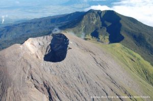
Kamchatka , Sheveluch :
On 28 March the Kamchatka Volcanological Station (KVS) reported that activity had increased at Sheveluch during the previous few days. Incandescence at the summit of the lava dome was constant and the focus of activity shifted from the E side to the NE side. KVERT reported that the ongoing eruption was generally characterized by explosions, hot avalanches, lava-dome extrusion, and strong fumarolic activity. A daily thermal anomaly was identified in satellite images during 30 March-6 April. Satellite images showed an ash plume drifting 250 km E and SE.
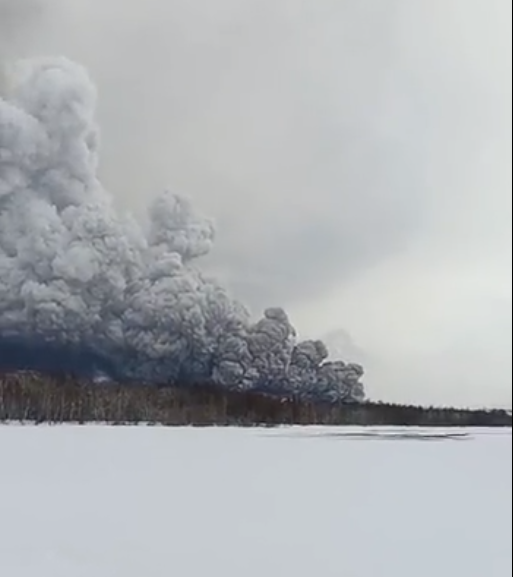
Seismic data around 00h54 local time on 11 April indicated a significant increase in activity, as reported by the Institute of Volcanology and Seismology, Far Eastern Branch, Russian Academy of Sciences (IVS FEB RAS). According to the Tokyo VAAC the ash plume had risen to 15.8 km (52,000 ft) a.s.l. by 01h10 and was drifting NW. By 01h58 the plume extended over a 75 x 100 km area. KVS reported that significant pulses of activity occurred at around 02h00, 03h20, and then a stronger phase started around 06h00. Video of the rising plume was taken at around 06h00 from near Békés (3 km away) by Levin Dmitry, who reported that a pyroclastic flow traveled across the road behind him as he left the area. Ashfall began in Klyuchi (45 km SW) at 06h30, and the large black ash plume had blocked the daylight by 07h00. At 07h29 KVERT issued a Volcano Observatory Notice for Aviation (VONA) raising the Aviation Color Code to Red (the highest level on a four-color scale). They stated that a large ash plume had risen to 10 km (32,800 ft) a.s.l. and drifted 100 km W. According to IVS FEB RAS the cloud was 200 km long and 76 km wide by 08h30, and was spreading W at altitudes of 6-12 km (19,700-39,400 ft) a.s.l.
KVS reported that at about 09h30 the plume drifted over Kozyrevsk (112 km SW) and turned the day to night. Almost constant lightning strikes in the plume were visible and sounds like thunderclaps were heard until about 10h00. The sky lightened up in Kozyrevsk at about 10h30; residents in Klyuchi reported continuing darkness and ashfall at 11h00. As the day went on the light had a reddish-brown hue due to the ash in the atmosphere. In some areas ashfall was 6 cm deep and some residents reported dirty water coming from their plumbing. At 11h50 an ash cloud 400 km long and 250 km wide was spreading W at altitudes of 5-20 km (16,400-65,600 ft) a.s.l., according to IVS FEB RAS. KVERT issued a VONA at 11h55 noting that ash had risen to 10 km and that it had extended 340 km NNW and 240 km WSW.
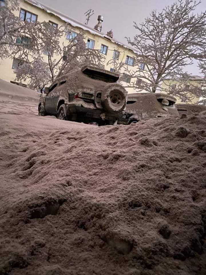
According to Simon Carn about 0.2 Tg of sulfur dioxide in the plume was measured in a satellite image acquired at 13h43. A satellite image at 17h48 showed ash plumes rising to 8 km (26,200 ft) a.s.l. and drifting 430 km WSW and S, based on a VONA. Residents of Klyuchi measured ashfall as thick as 8.5 cm, according to the Kamchatka Branch of Geophysical Services (KBGS; Russian Academy of Sciences). In a VONA issued at 07h48 on 12 April KVERT stated that strong explosions were continuing. Ash plumes from explosions rose to 8 km and drifted ESE. The larger ash cloud continued to drift and had extended 600 km SW and 1,050 km ESE. IVS FEB RAS scientists photographed the terminal part of a pyroclastic flow that had traveled 19 km SSE the day before, which had stopped a few hundred meters from a bridge on the road between Kliuchi and Petropavlovsk-Kamchatsky.
VOLCANO OBSERVATORY NOTICE FOR AVIATION (VONA)
Issued: April 12 , 2023
Volcano: Sheveluch (CAVW #300270)
Current aviation colour code: ORANGE
Previous aviation colour code: red
Source: KVERT
Notice Number: 2023-57
Volcano Location: N 56 deg 38 min E 161 deg 18 min
Area: Kamchatka, Russia
Summit Elevation: 3283 m (10768.24 ft), the dome elevation ~2500 m (8200 ft)

Volcanic Activity Summary:
An eruption of the volcano continues, its intensity has decreased over the past few hours. Satellite data by KVERT showed an ash plume extended about 400 km to the south-east from the volcano.
An eruption of the volcano continues. Ash explosions up to 10 km (32,800 ft) a.s.l. could occur at any time. Ongoing activity could affect international and low-flying aircraft.
Volcanic cloud height:
5000-5500 m (16400-18040 ft) AMSL Time and method of ash plume/cloud height determination: 20230412/1950Z – Himawari-9 14m15
Other volcanic cloud information:
Distance of ash plume/cloud of the volcano: 400 km (249 mi)
Direction of drift of ash plume/cloud of the volcano: SE / azimuth 125 deg
Time and method of ash plume/cloud determination: 20230412/1950Z – Himawari-9 14m15
Sources : Kamchatkan Volcanic Eruption Response Team (KVERT), Simon Carn, Kamchatka Volcanological Station, Institute of Volcanology and Seismology (IVS) of the Far Eastern Branch of the Russian Academy of Sciences (FEB RAS), Tokyo Volcanic Ash Advisory Center (VAAC), GVP.
Photos : YS Yaklasiyor ,Wulkany swiata , Vicktoriya Mirsanova
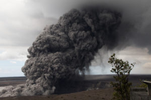
Colombia , Nevado del Ruiz :
Servicio Geológico Colombiano’s (SGC) reported that the number of daily events detected by the seismic network at Nevado del Ruiz fluctuated during 3-8 April but declined overall. Earthquakes were generally located 2-5 km SW of Arenas Crater at depths of 3-4 km. On 9 April SGC noted that daily counts of events were no longer going to be posted in their daily reports and instead the focus will be on the location of the earthquakes. Gas emissions had also decreased in density. That same day Gestión del Riesgo de Desastres (UNGRD) reported that 2,000-2,500 families had been identified as living in high-risk areas and requested that local authorities expedite a preventive evacuation; families that had evacuated were staying with family and friends and not in evacuation shelters.

During 3-11 April the earthquakes were associated with daily emissions of gas-and-steam and gas-and-ash plumes. Ash-and-gas plumes rose as high as 1.5 km above the crater rim on 3 April and drifted NW and SW. During 6-7 April several pulsating ash emissions were observed in webcam images and by residents of La Cabaña (Murillo, Tolima). The emissions rose as high as 1.5 km and drifted SE and NE. Webcam images and La Cabaña residents again saw ash emissions on 10 April, rising as high as 1.8 km and drifting E and NE. Thermal anomalies from Arenas Crater were periodically visible through the week. The Alert Level was remained at Orange, Level II (the second highest level on a four-level scale).
Sources : Servicio Geológico Colombiano (SGC), Gestión del Riesgo de Desastres (UNGRD), GVP.
Photo : Carlos Ortega.
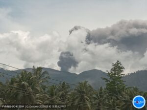
Indonésie , Semeru :
VOLCANO OBSERVATORY NOTICE FOR AVIATION – VONA
Issued : April 13 , 2023
Volcano : Semeru (263300)
Current Aviation Colour Code : ORANGE
Previous Aviation Colour Code : orange
Source : Semeru Volcano Observatory
Notice Number : 2023SMR130
Volcano Location : S 08 deg 06 min 29 sec E 112 deg 55 min 12 sec
Area : East java, Indonesia
Summit Elevation : 11763 FT (3676 M)
Volcanic Activity Summary :
Eruption with volcanic ash cloud at 05h49 UTC (12h49 local).
Volcanic Cloud Height :
Best estimate of ash-cloud top is around 13363 FT (4176 M) above sea level or 1600 FT (500 M) above summit. May be higher than what can be observed clearly. Source of height data: ground observer.
Other Volcanic Cloud Information :
Ash cloud moving from north to northeast. Volcanic ash is observed to be gray. The intensity of volcanic ash is observed to be thick.
Remarks :
Eruption recorded on seismogram with maximum amplitude 23 mm and maximum duration 118 second.
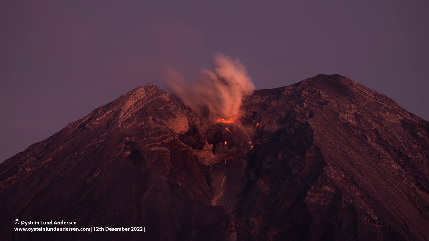
.PVMBG reported that the eruption at Semeru continued during 5-11 April and a few Volcano Observatory Notices for Aviation (VONAs) were issued through the week. At 05h59 on 8 April a dense white-to-brown plume rose 800 m above the summit and drifted NE. About an hour and a half later, at 07h32, a white-to-gray plume rose 600 m and drifted N. At 06h35 and 22h18 on 10 April variable white-and-gray plumes rose 500-800 m and drifted N and NE. At 05h35 on 11 April a dense white-and-gray plume rose 500 m and drifted N. The Alert Level remained at 3 (on a scale of 1-4). The public was warned to stay at least 5 km away from the summit in all directions, 13 km from the summit to the SE, 100 m from the banks of the Kobokan drainage as far as 17 km from the summit, and to avoid other drainages originating on Semeru, including the Bang, Kembar, and Sat, due to lahar, avalanche, and pyroclastic flow hazards.
Sources : Magma Indonésie , GVP.
Photo : Oystein Lund Andersen.
Costa Rica , Rincon de la Vieja :
Latitude: 10.83
Longitude:-85.324
Altitude: 1,916 meters above sea level
Observed activity:
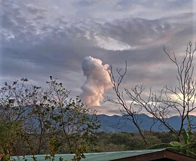
The tremor reappeared at the beginning of the night and with more amplitude from 10:30 p.m. A small eruption lasting a few minutes began at 6:53 a.m. with several pulses, the largest at 6:56 a.m. The gas plume rose about 500 m. Another expiration was recorded at 7:43 a.m. The tremor decreased in amplitude after 9 am.
Environmental conditions:
The wind is blowing southwest. Visibility conditions are variable.
Activity Level: Warning (2)
April 11, 2023.
A small phreatic eruption occurred on the Rincón de la Vieja volcano. Several pulses occurred between 6:53 a.m. and 7:00 a.m., the largest at 6:56 a.m. The volcano was cloudy, but still no ash is observed in the plume.
Source et photo : Ovsicori .