April 12 , 2023.
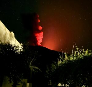
La Réunion , Piton de la Fournaise :
Press release from the Paris Institute of Earth Physics, Piton de la Fournaise Volcanological Observatory. April 11, 2023 – 11:00 a.m. (local time) – 09:00 a.m. (UTC time)
Increase in seismicity
Since March 30, 2023, an increase in seismicity has been observed under the Piton de la Fournaise: 66 volcano-tectonic earthquakes were recorded between March 30 and April 10 (Figure 1). These low magnitude earthquakes (<1) are located under the Dolomieu crater between 1.5 and 2.5 km deep.
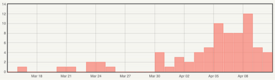
Figure 1: Histogram representing the number of superficial volcano-tectonic earthquakes recorded between March 15 and April 10, 2023 (© OVPF-IPGP).
This seismicity follows a resumption of the inflation of the summit of the Piton de la Fournaise building since the beginning of March 2023. This inflation is linked to a pressurization of the superficial magmatic reservoir located about 1.5-2 km from depth.

The appearance of seismicity at the roof of the reservoir shows that this process of pressurization is intensifying, even if the magnitude and number of earthquakes remain moderate.
It should be noted that this process of recharging the superficial reservoir can last several days to several weeks before the roof of the reservoir weakens and does not rupture, thus giving rise to an injection of magma towards the surface and an eruption, but can also stop without giving rise – in the short term – to an eruption.
Alert level: Vigilance
Source et photos : direction de l’OVPF-IPGP
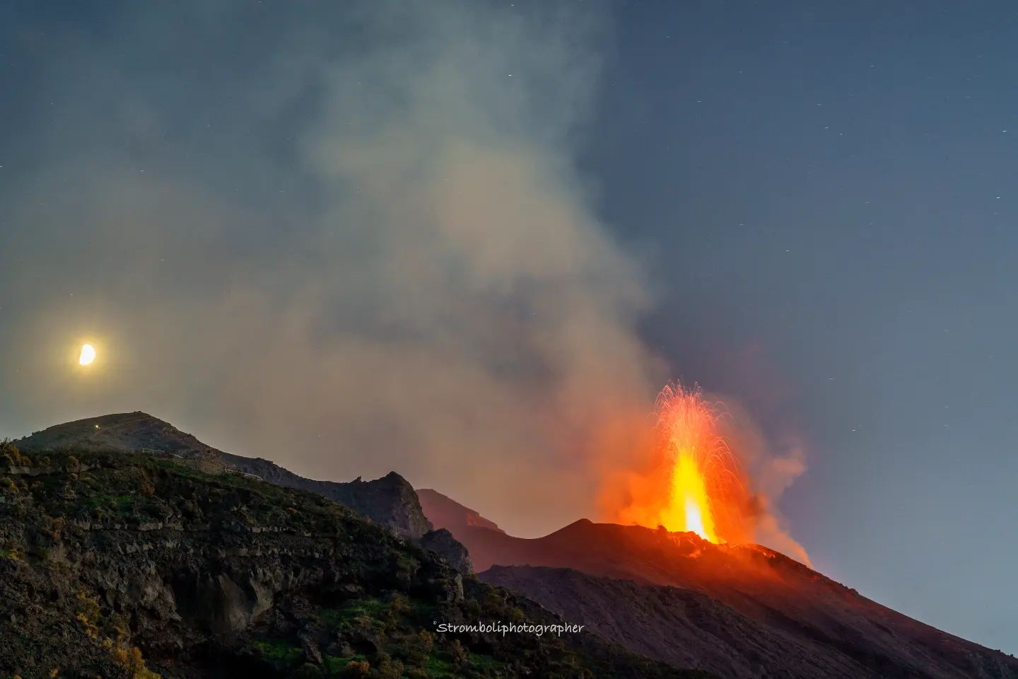
Italy , Stromboli :
WEEKLY BULLETIN, from April 03, 2023 to April 09, 2023. (issue date April 11, 2023)
ACTIVITY STATUS SUMMARY
In the light of the monitoring data, it is highlighted:
1) VOLCANOLOGICAL OBSERVATIONS: During this period, normal Strombolian activity was observed, interrupted by a major event in the area of the Center-South crater. The total hourly frequency fluctuated between medium (12 events/h) and medium-high (16 events/h) values. The intensity of the explosions was mainly low in both the North crater area and the South Center crater area.
2) SEISMOLOGY: The seismological parameters monitored do not show any significant variations.
3) GROUND DEFORMATIONS: The island’s ground deformation monitoring networks showed no significant changes to report during the week under review.
4) GEOCHEMISTRY: the flow of SO2 is at an average level
The CO2 streams show average degassing values.
There are no updates on the C/S report.
The isotopic ratio of the helium dissolved in the heat sinks is at average values with an R/Ra equal to 4.24 (last sampled on 06/03/2023).
VOLCANOLOGICAL OBSERVATIONS
During the observation period, the eruptive activity of Stromboli was characterized thanks to the analysis of the images recorded by the surveillance cameras of the INGV-OE at an altitude of 190m (SCT-SCV) and of the Pizzo . The explosive activity was mainly produced by 2 (two) eruptive vents located in the North zone of the crater and by 2 (two) vents located in the Center-South zone.
Due to the unfavorable weather conditions of April 3 and 9, the visibility of the crater area was insufficient for a correct description of the eruptive activity.
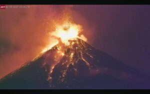
On April 7, a major event was produced by the Center-South zone.
Observations of explosive activity captured by surveillance cameras
In the area of the North crater (N), with a vent located in the N1 sector and one in the N2 sector, a low intensity explosive activity (less than 80 m in height) emitting fine materials was observed until 6 April and emitting coarse materials (bombs and lapilli) after the big event of April 7. The average frequency of explosions fluctuated between 7 and 11 events/h.
In the Center-South (CS) zone, the S2 sector, with two active vents, showed mainly low-intensity explosive activity emitting fine materials. Sector C and sector S1 did not show significant eruptive activity. The average frequency of explosions varies between 4 and 7 events/h.
Event of April 7, 2023.
On April 7, 2023, an explosive sequence affected sector S2 of the Center-South crater area. Below is the event description and times in UTC.
11:03:30 (Fig. 3.3 a) a first explosion lasting about 18 seconds exceeded the height of 400 m above the crater area (Fig. 3.3 b-d) with the main dispersion and fallout pyroclastic products in the upper part of the Sciara del Fuoco.
11:04:21 a second explosion of lower intensity and lasting about 4 s (fig. 3.3 c-e) characterized by the fallout of pyroclastic products also outside the crater area near Pizzo sopra la Fossa.
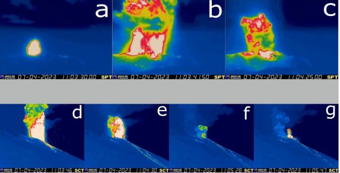
11:05:13 a third explosion mainly composed of ash of medium intensity (about 150 m high) with a duration of about 20 s (Fig.3.3 f)
11:05:41 A fourth explosion of medium-high intensity (about 200 m high) and duration of about 7 s, with coarse materials mixed with fine materials, completes the explosive sequence (Fig. 3.3 g).
The total duration of the event is approximately 2 min and 20 s.
Source : INGV.
Photos : Stromboli stati d’animo , ingv.
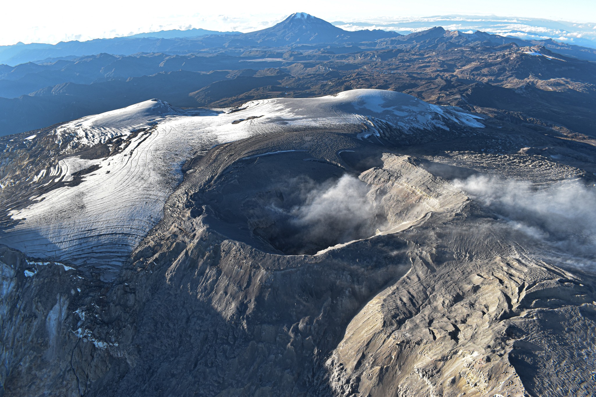
Colombia , Nevado del Ruiz :
Manizales, April 11, 2023 10:00 a.m.
Regarding the monitoring of the activity of the NEVADO DEL RUIZ VOLCANO, the MINISTRY OF MINES AND ENERGY through the COLOMBIAN GEOLOGICAL SERVICE (SGC) informs that:
The seismic activity associated with the fracturing of the rock inside the volcanic edifice continues to be located in the southwestern sector of the volcano, at depths between 2 and 4 km and at a distance from the crater between 2 and 6 km. Yesterday, the maximum magnitude was 1.9 corresponding to the 7:59 a.m. earthquake, located about 4 km southwest of the crater and about 3 km deep below the summit of the volcano.
The seismicity related to the movement of fluids inside the volcanic conduits and associated with the continuous emission of ash persisted for much of April 10 and until the present day. The maximum height of the column of gas and / or ash observed was 2300 m, measured from the summit of the volcano with a direction of dispersion which oscillated between the North and the North-East. The emission of sulfur dioxide into the atmosphere showed a slight increase compared to previous days. Localized thermal anomalies continue to be observed in the Arenas crater.
It is very important to clarify that the activity of the Nevado del Ruiz volcano continues to be very unstable.
Although the seismicity associated with the fracturing of the rocks has decreased in recent days, other parameters show that the activity of the volcano continues. In fact, this type of seismicity is no longer the main indicator of the activity of the volcano. The seismicity linked to the movement of fluids inside the volcanic conduits, and the persistence of thermal anomalies located in the Arenas crater begin to gain relevance. .
The level of activity of the volcano remains at the ORANGE LEVEL of activity or (II): PROBABLE ERUPTION IN TERM OF DAYS OR WEEKS
Source et photo : SGC.
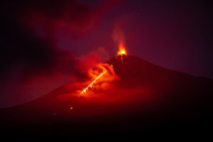
Kamchatka , Sheveluch :
VOLCANO OBSERVATORY NOTICE FOR AVIATION (VONA)
Issued: April 12 , 2023
Volcano: Sheveluch (CAVW #300270)
Current aviation colour code: RED
Previous aviation colour code: red
Source: KVERT
Notice Number: 2023-56
Volcano Location: N 56 deg 38 min E 161 deg 18 min
Area: Kamchatka, Russia
Summit Elevation: 3283 m (10768.24 ft), the dome elevation ~2500 m (8200 ft)
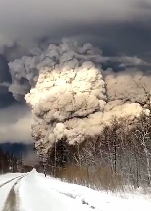
Volcanic Activity Summary:
Strong explosive eruption volcano continues. Ash column rose up to 7 km a.s.l. and ash plum extended about 1300 km to the east of the volcano.
An eruption of the volcano continues. Ongoing activity could affect international and low-flying aircraft.
Volcanic cloud height:
7000 m (22960 ft) AMSL Time and method of ash plume/cloud height determination: 20230412/0350Z – Himawari-9 14m15
Other volcanic cloud information:
Distance of ash plume/cloud of the volcano: 1300 km (808 mi)
Direction of drift of ash plume/cloud of the volcano: E / azimuth 96 deg
Time and method of ash plume/cloud determination: 20230412/0350Z – Himawari-9 14m15
Source : Kvert.
Photo : Ys Yaklasiyor.
Peru , Sabancaya :
Analysis period: from April 03, 2023 to April 09, 2023, Arequipa, April 10, 2023.
Alert level: ORANGE
The Geophysical Institute of Peru (IGP) reports that the eruptive activity of the Sabancaya volcano remains at moderate levels, that is to say with the recording of an average of 29 daily explosions, with columns of ash and of gas up to 1.6 km altitude above the summit of the volcano and their subsequent dispersion. Therefore, for the following days, no significant change is expected in eruptive activity.
The IGP recorded and analyzed the occurrence of 275 earthquakes of volcanic origin, associated with the circulation of magmatic fluids inside the Sabancaya volcano. An average of 29 explosions was recorded daily, in addition to recording Volcano-Tectonic (VT) type events associated with rock fracturing inside the Sabancaya volcano.

Monitoring the deformation of the volcanic structure using GNSS techniques (processed with fast orbits) does not show any significant anomalies. Visual surveillance identified columns of gas and ash up to 1.6 km above the summit of the volcano, which were scattered towards the West, South, South-West and North-West sectors. of the Sabancaya. Satellite recordings have identified the presence of 5 thermal anomalies, with a maximum value of 8 MW, associated with the presence of a lava body on the surface of the crater of the volcano.
RECOMMENDATIONS
• Keep the volcanic alert level orange.
• Do not approach within a radius of less than 12 km from the crater.
Source : Cenvul
Photo : Ingemmet.