December 22 , 2022.
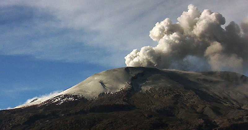
Italy , Stromboli :
Statement on Stromboli activity, December 21, 2022, 16:40 (15:40 UTC).
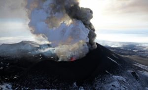
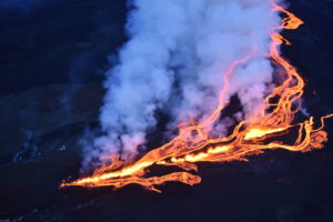
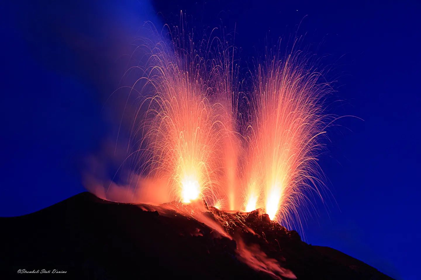
The National Institute of Geophysics and Volcanology, Osservatorio Etneo, communicates that through surveillance cameras, an overflow lava flow from the North Crater area is observed. The phenomenon was preceded by intense splashing activity.
During the last 24 hours, the average amplitude of the volcanic tremor has not shown significant variations and remains within the range of average values.
The GNSS network does not show significant variations.

Statement on Stromboli activity, December 22, 2022, 08:46 (07:46 UTC).
The National Institute of Geophysics and Volcanology, Osservatorio Etneo, communicates that from the analysis of the images of the surveillance cameras, it can be observed that during the night, the feeding of the lava flow described in the press release of previous press has gradually declined, and currently the casting is cooling. Ordinary explosive activity coupled with spatter activity continues in the North Crater area; during the observation period, no activity was detected in the area of the Center-South crater. From the seismic point of view, the average amplitude of the volcanic tremor did not show any significant changes compared to the previous release and remains within the range of average values. There are no significant variations in the occurrence rate of explosive earthquakes. The GNSS network shows no significant variation.
Further updates will be communicated soon.
The rejuvenation of the volcano discovered by analyzing the eruptive products
By analyzing the minerals present in the eruptive rocks of Stromboli during the paroxysms of 2019, the researchers discovered a temporal correspondence between the changes in the magmatic feeding system and the changes in the state of activity of the volcano recorded by the networks. surveillance in the months preceding the eruptions.
Analysis of crystals found inside products from Stromboli during the paroxysms of 2019 showed a rejuvenation of the magmatic system and a significant coherence between the chemical modifications of the rocks that occurred in the month preceding the eruptions and the data recorded in the same time interval by monitoring networks.
« The aim of our study was to deepen the magmatic dynamics of the Stromboli system and the changes that have occurred over the past twenty years, paying particular attention to the two paroxysms of the summer of 2019 », explains Piergiorgio Scarlato, volcanologist of the INGV. « Among the most significant results we have obtained is certainly evidence that Stromboli’s deep recharge system has been replenished by the influx of new deep, hotter, volatile-rich magma. The diffusion models applied to the chemical compositions measured on 65 crystals of clinopyroxene (mineral always present in magmatic rocks from stromboli) showed that more than 70% of the « recharge » events of the volcanic system, recorded in the period of analysis , began about a month before the eruption of July 3 (first paroxysm of 2019), consistent with the increase in eruptive activity observed”.
Source : INGV.
Photos : Stromboli Stati d’animo .
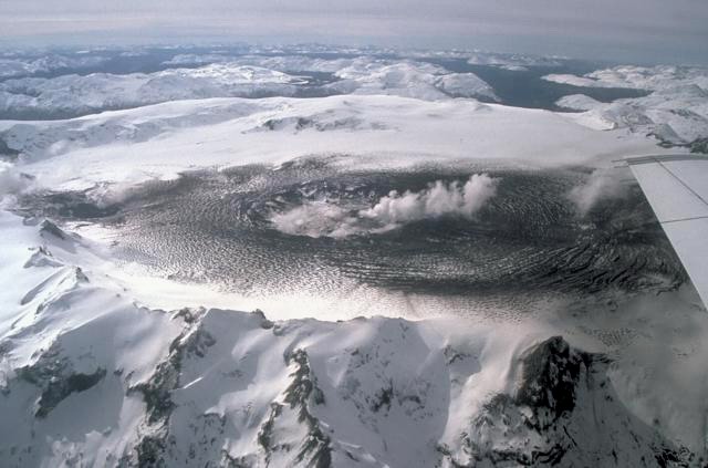
Chile , Hudson :
Special Report on Volcanic Activity (REAV), Aysen Del General Carlos Ibanez Del Campo Area, Hudson Volcano, December 21, 2022, 1:40 p.m. local time (mainland Chile).
The National Service of Geology and Mines of Chile (Sernageomin) publishes the following PRELIMINARY information, obtained through the monitoring equipment of the National Volcanic Monitoring Network (RNVV), processed and analyzed at the Volcanological Observatory of the Southern Andes ( Ovdas):
On Wednesday December 21, 2022, at 13:11 local time (16:11 UTC), the monitoring stations installed near the Hudson volcano recorded an earthquake associated with both rock fracturing (volcano-tectonic type) and fluid dynamics in the volcanic system (hybrid type).
The characteristics of earthquakes after their analysis are as follows:
ORIGINAL TIME: 13:11 local time (16:11 UTC)
LATITUDE: 45.876°S
LONGITUDE: 72.987°E
DEPTH: 3.1 km
REDUCED DISPLACEMENT: 1405 (cm*cm)
LOCAL MAGNITUDE: 3.0 (ML)
COMMENTS:
Following the event, no changes in the behavior of the volcano were recorded.
The volcanic technical alert remains at the Green level.
Sources : Sernageomin.
Photo : Norm Banks
Colombia , Nevado del Ruiz :
Bulletin of activity level of the Nevado del Ruiz volcano.
The activity level continues at the yellow activity level or (III): changes in the behavior of volcanic activity.
Regarding the monitoring of the activity of the Nevado del Ruiz volcano, the COLOMBIAN GEOLOGICAL SERVICE reports that:
Seismic activity related to fluid dynamics within volcanic conduits maintained similar levels in the number of events recorded compared to the previous week.
The decreasing energy of the continuous volcanic tremor signal stands out, which continues to occur with low energy levels. Through images captured by the cameras installed in the volcano area and by the reports of the staff of the National Natural Park of Los Nevados, various pulsating emissions of gas and ash associated with some of the seismic signals and, sometimes, in constant emissions during time periods of several hours have been confirmed. Ash falls were reported in the municipalities of the departments of Risaralda, Tolima and Caldas located in the direction of the prevailing wind (southwest and northwest).
Seismic activity associated with rock fracturing increased in the number of recorded earthquakes and maintained similar levels in released seismic energy compared to the previous week. The earthquakes were located mainly in the North-East, South-East, distal North-West sectors and in the Arenas crater.
The depth of the earthquakes ranged from about 0.5 to 8.0 km. The maximum magnitude observed during the week was 1.1 ML (Local Magnitude) corresponding to the earthquake recorded on December 20 at 07:37 (local time), located about 3.4 km southeast of the crater, at a depth of 4.0 km.
Deformation of the volcanic surface continues to show minor changes.
Source et photo : SGC
Japan , Suwanosejima :
JMA reported that the eruption at Suwanosejima’s Ontake Crater continued during 12-19 December. No explosions were recorded. Eruption plumes rose at least 1.7 km above the crater rim and blocks were ejected as far as 100 m from the vent. Crater incandescence was visible at night during 12-16 December and ashfall was occasionally reported in Toshima village (3.5 km SSW) during 16-19 December. The Alert Level remained at 3 (on a 5-level scale), and residents were warned to stay 2 km away from the crater.
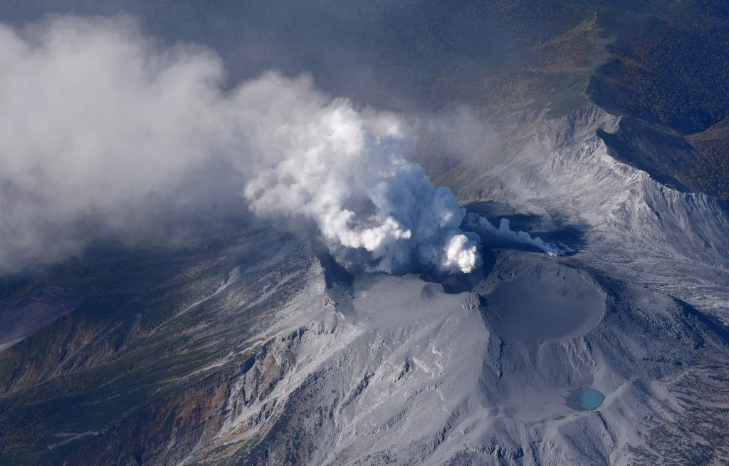
The 8-km-long island of Suwanosejima in the northern Ryukyu Islands consists of an andesitic stratovolcano with two historically active summit craters. The summit is truncated by a large breached crater extending to the sea on the east flank that was formed by edifice collapse. One of Japan’s most frequently active volcanoes, it was in a state of intermittent Strombolian activity from Otake, the NE summit crater, between 1949 and 1996, after which periods of inactivity lengthened. The largest recorded eruption took place in 1813-14, when thick scoria deposits blanketed residential areas, and the SW crater produced two lava flows that reached the western coast. At the end of the eruption the summit of Otake collapsed, forming a large debris avalanche and creating the open Sakuchi caldera, which extends to the eastern coast. The island remained uninhabited for about 70 years after the 1813-1814 eruption. Lava flows reached the eastern coast of the island in 1884. Only about 50 people live on the island.
Source : GVP , Japan Meteorological Agency (JMA)
Photo : Masanori Genko
Ecuador , Cotopaxi :
Information on the activity of the Cotopaxi volcano, THURSDAY DECEMBER 22, 2022
At 10:10 p.m. local time, the Washington VAAC issued a northbound ash cloud alert. Thanks to satellite images (GOES-16), a gas plume with a very weak ash load is observed, the emission would reach about 1000 meters above the crater and the wind speed is high towards the North. Therefore, there is a low probability of ash fall in the vicinity of the Cotopaxi National Park as well as in the Valle de los Chillos sector, in the canton of Quito and Rumiñahui. This event is similar to others that have occurred in recent days. The IG-EPN will inform in a timely manner in case of detection of significant changes in the activity of the volcano. It is recommended to take appropriate measures and receive information from official sources.
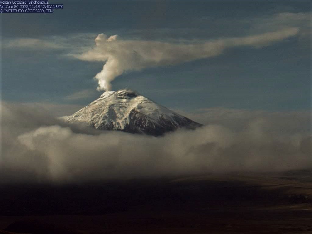
IG reported that the low-level eruption at Cotopaxi continued during 14-20 December, characterized by daily steam-and-gas emissions with low ash content. At 06h26 on 14 December an ash emission rose 500 m above the crater rim and drifted W, causing ashfall within Parque Nacional Cotopaxi. Weather clouds sometimes obscured views of the volcano; between weather clouds during 14-16 December steam-and gas plumes with low ash content were seen rising as high as 500 m above the crater rim and drifting W. Several emissions with low or very low ash content rose as high as 800 m above the crater rim and drifted W and SW during 16-17 December; similar emissions rose as high as 1.1 km above the crater rim and drifted W and SW during 18-20 December based on webcam views and Washington VAAC notices. Ashfall was reported in San Pedro de Taboada (40 km N), Uyumbicho (30 km NNW), Güitig Alta, Güitig Baja, Conocoto (42 km N), Sur de Quito, Chimbacalle (48 km NNW), La Magdalena (48 km NNW), Barrio Nuevo, Villaflora (48 km NNW), Miraflores, and La Floresta (50 km N) during 19-20 December. Servicio Nacional de Gestión de Riesgos y Emergencias (SNGRE) maintained the Alert Level at Yellow (the second lowest level on a four-color scale).
Sources : IGEPN , GVP.
Photo : IGEPN.