November 27 , 2022.
Ecuador , Cotopaxi :
Information on the activity of the COTOPAXI volcano, Quito, Saturday November 26, 2022.
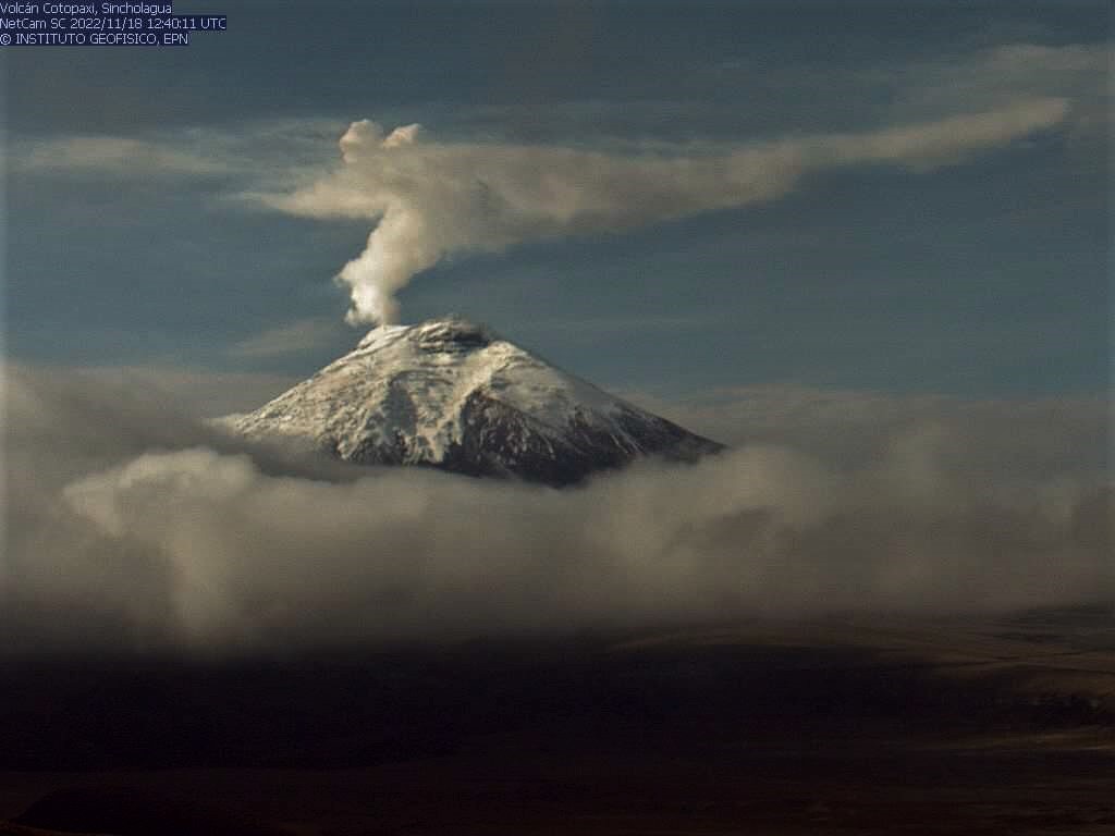
From 03:10 TL, the seismic stations of the Cotopaxi volcano record a tremor signal associated with an emission of gas and ash, which were reported in instant alert message No. 2022 – 011. The broadcast was confirmed by GOES-16 satellite and later with IG-EPN cameras. The ash plume is heading north and reports of ash fall have been received in Tambillo, Amaguaña, Guamaní and south of Quito. The amplitude of the seismic signal is low compared to the activity of 2015, however it remained sustained for several hours.
The IG-EPN continues to monitor the event and will inform in a timely manner if any changes in the seismic signals are detected. It is recommended to take appropriate measures and receive information from official sources.
Special Volcanic Bulletin – Cotopaxi – 2022- N° 003
Summary :
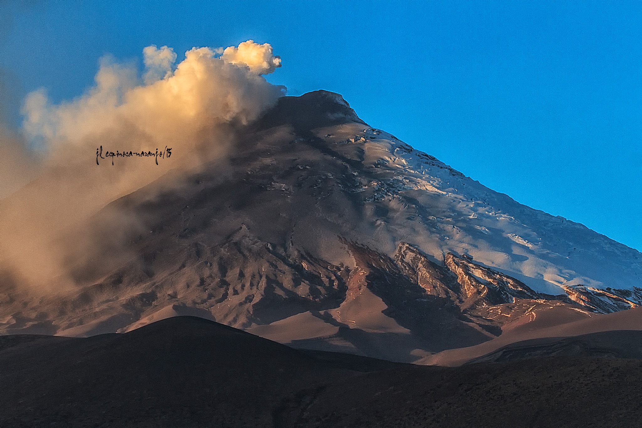
On the night of October 21, 2022, a low frequency tremor signal associated with an emission of gas and ash was recorded which produced a slight fall of volcanic material on the northern flank of the Cotopaxi volcano, including on the José Rivas Refuge .
Since then, steam and gas emissions have been nearly continuous and clearly visible, with plumes reaching up to 2 km above crater level.
The parameters monitored by the IG-EPN show an activity slightly above the reference level established since the end of the eruptive period of Cotopaxi in November 2015. The observations of the monitoring parameters until November 22, 2022 have been compiled in the Report Volcanic Special – Cotopaxi – 2022- N° 002. In this report, it was concluded that « the joint analysis of the various monitoring data shows that the current activity of Cotopaxi is caused by the presence of magma in the volcanic conduit » .
Development
On Friday, November 25, 2022, from 6:48 p.m. TL, the seismic stations of the Cotopaxi volcano recorded a tremor signal associated with a gas emission, with a NNO direction, which was visible through the GOES-16 satellite images. The IG-EPN reported this activity through the IG instantly VOLCÁN COTOPAXI n° 2022-010.
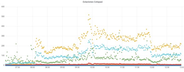
Figure 1.- RSAM of the Cotopaxi volcano stations in the 2-8Hz frequencies. Corresponding to the ash emission recorded at dawn on Saturday November 26, 2022. The RSAM is a measure of the amplitude of the seismic signal.
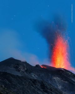
Later in the morning of today November 26, from about 03:10 TL, a new episode of tremor associated with the emission of gas and ash was recorded. Although initially the ash cloud did not extend very far from the vicinity of the volcano, later the emission lasted much longer than the previous pulses, extending over several hours (Figure 1). Favored by the winds directed towards the North-North-West, the ashes traveled more than 85 km from the source (Figure 2 and 3) for which ash falls were reported in the sectors of: El Pedregal, Tambillo, Guamaní , Amaguaña, Chillogallo, Quitumbe, Solanda, Lloa, Conocoto, Mercado Mayorista, Villaflora and Rumipamba.
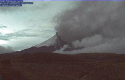
Figure 2.- Emission of ash from the Cotopaxi volcano in the NNO direction. Camera de la Merced 05h53TL.
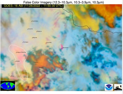
Figure 3.- GOES-16 satellite image showing the NNW direction of the ash plume, we can see how it moved over the city of Quito, covering a distance of 85 km.
At the time of publication of this report, the surface activity of the Cotopaxi volcano has decreased, but it continues, however, the internal seismic activity, marked by the seismic tremor of moderate size, was maintained until 10:50 TL , to go down to basic levels. We should point out that this activity is part of the eruptive scenarios published in the previously published report and is classified as: Moderate Internal Uptrend and Moderate Shallow Uptrend.
IG-EPN continues to monitor the mild eruptive event and will inform in a timely manner if any changes in volcanic activity are detected. It is recommended to take appropriate measures and receive information from official sources.
Recommendations in the event of ash fall
Ashes can be hazardous to health. They can irritate the skin and especially cause eye and respiratory problems. Children, people with respiratory problems and the elderly are particularly vulnerable.
The most important thing in the event of an ash fall is not to go out unless strictly necessary, stay at home and close doors and windows tightly. If we go out, it is necessary to wear long pants, gloves, closed shoes, long-sleeved clothes and a cap or hat, because the ash can cause skin and scalp irritation. It is essential to protect our respiratory tract with a mask or, failing that, a damp handkerchief. It is also vitally important to use eye protectors that have a good seal, industrial safety goggles or swimming goggles are suggested.
Source : IGEPN
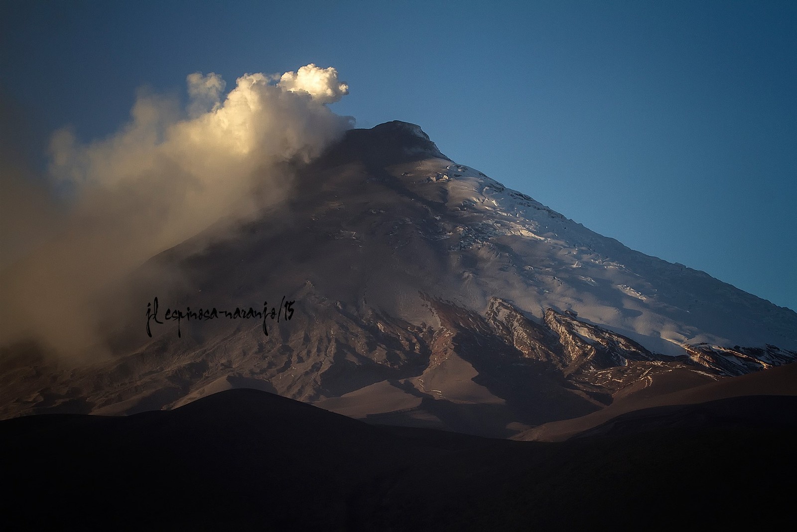
Photos : JL Espinosa Naranjo , IGEPN.
Philippines , Mayon :
MAYON VOLCANO BULLETIN 26 November 2022 8:00 AM
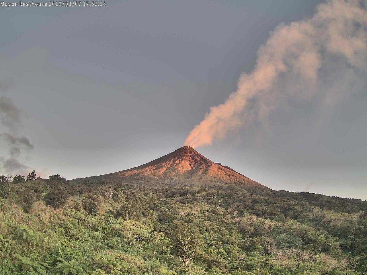
In the past 24-hour period, the Mayon Volcano Network did not detect any volcanic earthquake. Moderate emission of white steam-laden plumes that crept downslope before drifting to the west-southwest and west-northwest was observed. Sulfur dioxide (SO2) emission was last measured at an average of 788 tonnes/day on 23 November 2022. Based on ground deformation parameters from EDM, Precise Leveling, electronic tilt, and continuous GPS monitoring, Mayon Volcano has been slightly inflated since 2020.
Alert Level 2 (Increased Unrest) prevails over Mayon Volcano. The public is reminded that there is current unrest driven by shallow magmatic processes that could eventually lead to phreatic eruptions or even precede hazardous magmatic eruptions. Entry into the six (6) kilometer-radius Permanent Danger Zone (PDZ) is strictly prohibited to minimize risks from sudden explosions, rockfalls, and landslides. In case of ash fall events that may affect communities downwind of Mayon’s crater, people should cover their nose and mouth with a damp, clean cloth, or dust mask. Civil aviation authorities must also advise pilots to avoid flying close to the volcano’s summit as ash from any sudden eruption can be hazardous to aircraft.
DOST-PHIVOLCS maintains close monitoring of Mayon Volcano and any new development will be communicated to all concerned stakeholders.
Source : Phivolcs
Photo : volcanodiscovery
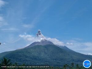
Indonesi , Semeru :
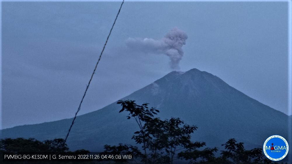
Mount Semeru erupted on Saturday November 26, 2022 at 04:44 WIB with an ash column height observed at ± 700 m above the summit (± 4376 m above sea level). The ash column was observed to be gray with a thick intensity oriented to the south. This eruption was recorded on a seismograph with a maximum amplitude of 23 mm and a duration of 126 seconds.
VOLCANO OBSERVATORY NOTICE FOR AVIATION – VONA
Issued : November 26 , 2022
Volcano : Semeru (263300)
Current Aviation Colour Code : ORANGE
Previous Aviation Colour Code : orange
Source : Semeru Volcano Observatory
Notice Number : 2022SMR701
Volcano Location : S 08 deg 06 min 29 sec E 112 deg 55 min 12 sec
Area : East java, Indonesia
Summit Elevation : 11763 FT (3676 M)
Volcanic Activity Summary :
Eruption with volcanic ash cloud at 22h52 UTC (05h52 local).
Volcanic Cloud Height :
Best estimate of ash-cloud top is around 13363 FT (4176 M) above sea level or 1600 FT (500 M) above summit. May be higher than what can be observed clearly. Source of height data: ground observer.
Other Volcanic Cloud Information :
Ash cloud moving to south. Volcanic ash is observed to be white to gray. The intensity of volcanic ash is observed to be medium.
Remarks :
Eruption recorded on seismogram with maximum amplitude 22 mm and maximum duration 85 second. –
Source et photo : Magma Indonésie .
La Martinique , Mount Pelée :
Weekly report on the activity of Mount Pelée for the period from November 18, 2022 to November 25, 2022.
Between November 18, 2022 at 4 p.m. (UTC) and November 25, 2022 at 4 p.m. (UTC), the OVSM recorded at least 1 volcano-tectonic earthquake of magnitude less than 1 and not located. It is identical to those of the well-known families on Pelee which are located inside the volcanic edifice around 0.4 km deep above sea level or about 1 km deep below the summit. This superficial volcano-tectonic seismicity is associated with the formation of micro-fractures in the volcanic edifice. During the period of this report, the OVSM also recorded 4 hybrid-type earthquakes and 1 long-period type earthquake. These signals containing low frequencies are associated with the presence of fluids (gas, hydrothermal water) in the volcanic edifice.
None of these earthquakes was felt by the population.

During volcanic reactivation phases of volcanoes similar to Mount Pelee, periods of higher seismic activity often alternate with phases of lower seismicity. Since the reactivation of the hydrothermal-magmatic system (end of 2018), several periods of zero or weak seismicity have been recorded by the OVSM, such as only 8 earthquakes between June 24 and August 8, 2022 (period of 2 months).
The areas of degraded vegetation located between Morne Plumé and the Chaude River were observed during a helicopter flight carried out on February 9 and May 5, with the support of Dragon 972, and confirmed by analysis of satellite and drone images. (overview of May 11) and satellite analysis (June 2022). A new area of degraded vegetation, located just north of the Chaude River, was observed from August 26th.
The alert level remains YELLOW: vigilance.
Source : OVSM-IPGP.
Photo : Parc naturel Martinique.
Hawaii , Kilauea :
19°25’16 » N 155°17’13 » W,
Summit Elevation 4091 ft (1247 m)
Current Volcano Alert Level: WATCH
Current Aviation Color Code: ORANGE
Activity Summary:
The summit eruption of Kīlauea Volcano, within Halemaʻumaʻu crater, continued over the past 24 hours. All recent eruptive activity has been confined to the crater. No significant changes have been observed at the summit or in either rift zone.
Halemaʻumaʻu Lava Lake Observations:
Eruption of lava from the western vent into the active lava lake and onto the crater floor continued over the past 24 hours. The active part of the lava lake has been steady over the past 24 hours. Overflight measurements from October 28, 2022, indicated that the crater floor had seen a total rise of about 143 meters (469 feet), and that 111 million cubic meters (29.2 billion gallons) of lava had been effused since the beginning of this eruption on September 29, 2021.

This tall, thin hornito on the eastern side of the crater floor of Halemaʻumaʻu is made up of spatter. The spatter made its way through a crack in the thick, solidified lava that forms the base of Halema‘uma‘u crater, at the summit of Kīlauea. The yellow and white patches at the bottom are from sulfur that has come out of the magma precipitating on the lava.
Summit Observations:
Tilt records have been stable over the past 5 days. Volcanic tremor remains above background levels. A sulfur dioxide (SO2) emission rate of approximately 300 tonnes per day (t/d) was measured on November 22, 2022.
Rift Zone Observations:
No unusual activity has been noted along the East Rift Zone or Southwest Rift Zone; low rates of ground deformation and seismicity continue along both. Measurements from continuous gas monitoring stations downwind of Puʻuʻōʻō in the middle East Rift Zone remain below detection limits for SO2, indicating that SO2 emissions from Puʻuʻōʻō are negligible.
Source : HVO.
Photo : USGS / D. Downs.