November 20 , 2022.
Kamchatka , Sheveluch :
VOLCANO OBSERVATORY NOTICE FOR AVIATION (VONA)
Issued: November 20 , 2022
Volcano: Sheveluch (CAVW #300270)
Current aviation colour code: ORANGE
Previous aviation colour code: orange
Source: KVERT
Notice Number: 2022-179
Volcano Location: N 56 deg 38 min E 161 deg 18 min
Area: Kamchatka, Russia
Summit Elevation: 3283 m (10768.24 ft), the dome elevation ~2500 m (8200 ft)
Volcanic Activity Summary:
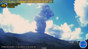
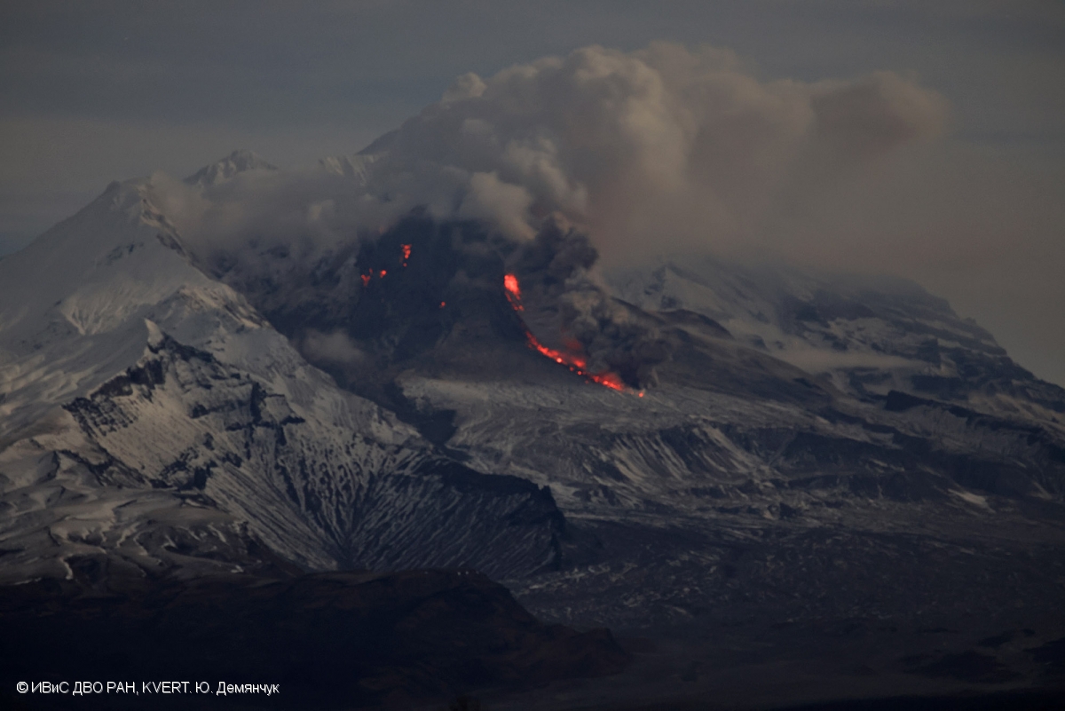
A growth of the lava dome continues, a strong fumarole activity, an incandescence of the lava dome, explosions, and hot avalanches accompanies this process. Video data by KVERT showed an ash plume associated with hot avalanches collapses is extending for 10 km to the north-east of the volcano.
The extrusive eruption of the volcano continues. Ash explosions up to 10-15 km (32,800-49,200 ft) a.s.l. could occur at any time. Ongoing activity could affect international and low-flying aircraft.
Volcanic cloud height:
4600 m (15088 ft) AMSL Time and method of ash plume/cloud height determination: 20221120/0232Z – Video data
Other volcanic cloud information:
Distance of ash plume/cloud of the volcano: 10 km (6 mi)
Direction of drift of ash plume/cloud of the volcano: E / azimuth 80 deg
Time and method of ash plume/cloud determination: 20221120/0232Z – Video data
Source : Kvert.
Photo : Yu. Demyanchuk, IVS FEB RAS, KVERT.
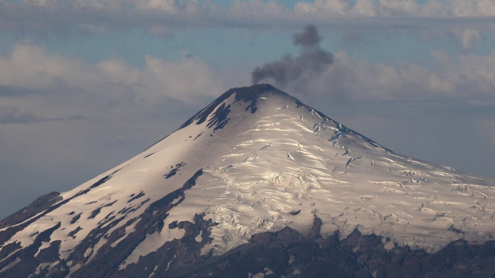
Chile , Villarica :
Special Report on Volcanic Activity (REAV), La Araucanía and Los Ríos regions, Villarrica volcano, November 20, 2022, 00:30 a.m. local time (mainland Chile)
The National Geology and Mining Service of Chile (Sernageomin) announces the following PRELIMINARY information, obtained through the monitoring equipment of the National Volcanic Monitoring Network (RNVV), processed and analyzed at the Observatory of Volcanoes of the Southern Andes (Ovdas):
On November 19, from 7:40 p.m. local time (22:40 UTC), the monitoring stations installed near the Villarrica volcano recorded a seismic swarm of 21 VT type events associated with rock fracturing (Volcano-Tectonic), on a period of 75 minutes, located 7.8 km east-southeast of the crater of the Villarrica volcano. After its appearance, the seismic activity VT showed a decrease in its events.

The characteristics of the earthquake with the largest recorded local magnitude, after its analysis, are as follows:
ORIGINAL TIME: 8:07 p.m. local time (23:07 UTC)
LATITUDE: 39.445°S
LONGITUDE: 71.855° W
DEPTH: 2.5 km
LOCAL MAGNITUDE: 1.6 (ML)
Compared to the energy of the continuous signal with the RSAM (measurement of the seismic amplitude averaged by lapse of time) it is maintained with an increasing tendency, reaching a value of 1.1 um/sec, behavior observed during the last month.
This suggests that the volcanic process is continuing with a level of activity above its baseline threshold. The recording of VT activity in the East-South-East source (described in this report) and the behavior of the continuous seismic signal increase, suggest phases of volcanic activity that could lead to process-related surface phenomena. shallow lava lake. In this context, small explosions that emit particulate matter and pyroclasts can be recorded in the area surrounding the crater.
Therefore, the volcanic technical alert is maintained at the Yellow level.
COMMENTS:
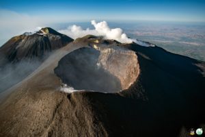
A potential impact zone is considered within a radius of 500 m around the center of the active crater. The coordinates of the crater center are 39°25’11.98″S and 71°56’22.90″W
Source : Sernageomin
Photos : Sernageomin , 24 horas.
Colombia , Nevado del Ruiz :
Bulletin of activity level of the Nevado del Ruiz volcano.
The activity level continues at: yellow activity level or (III): changes in the behavior of volcanic activity.
Regarding the monitoring of the activity of the Nevado del Ruiz volcano, the COLOMBIAN GEOLOGICAL SERVICE reports that:
Seismic activity associated with rock fracturing increased both in the number of earthquakes recorded and in the seismic energy released compared to the previous week. The earthquakes were located mainly in the South-West, North-East sectors and, in a scattered manner, in the other sectors of the volcanic edifice. The depth of the earthquakes fluctuated between about 0.6 and 7 km. The maximum magnitude observed during the week was 3.1 ML (Local Magnitude) corresponding to the earthquake recorded on November 10 at 02:25 (local time), located 2.7 km southwest of the crater at a depth of 3 .6 km.
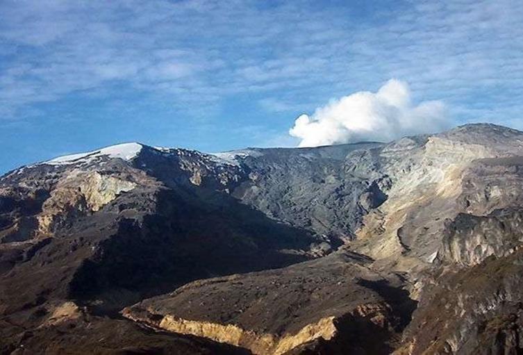
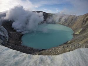
Seismic activity related to fluid dynamics within volcanic conduits decreased in number of earthquakes recorded and increased in seismic energy released, compared to the previous week. Thanks to images captured by cameras installed in the volcano area, the gas and ash emissions associated with some of these seismic signals have been confirmed.
Deformation of the volcanic surface continues to show minor changes.
Source : SGC.
Photo : Alertatolima.com
Hawaii , Kilauea :
19°25’16 » N 155°17’13 » W,
Summit Elevation 4091 ft (1247 m)
Current Volcano Alert Level: WATCH
Current Aviation Color Code: ORANGE
Activity Summary:
The summit eruption of Kīlauea Volcano, within Halemaʻumaʻu crater, continued over the past 24 hours. All recent eruptive activity has been confined to the crater. No significant changes have been observed at the summit or in either rift zone.
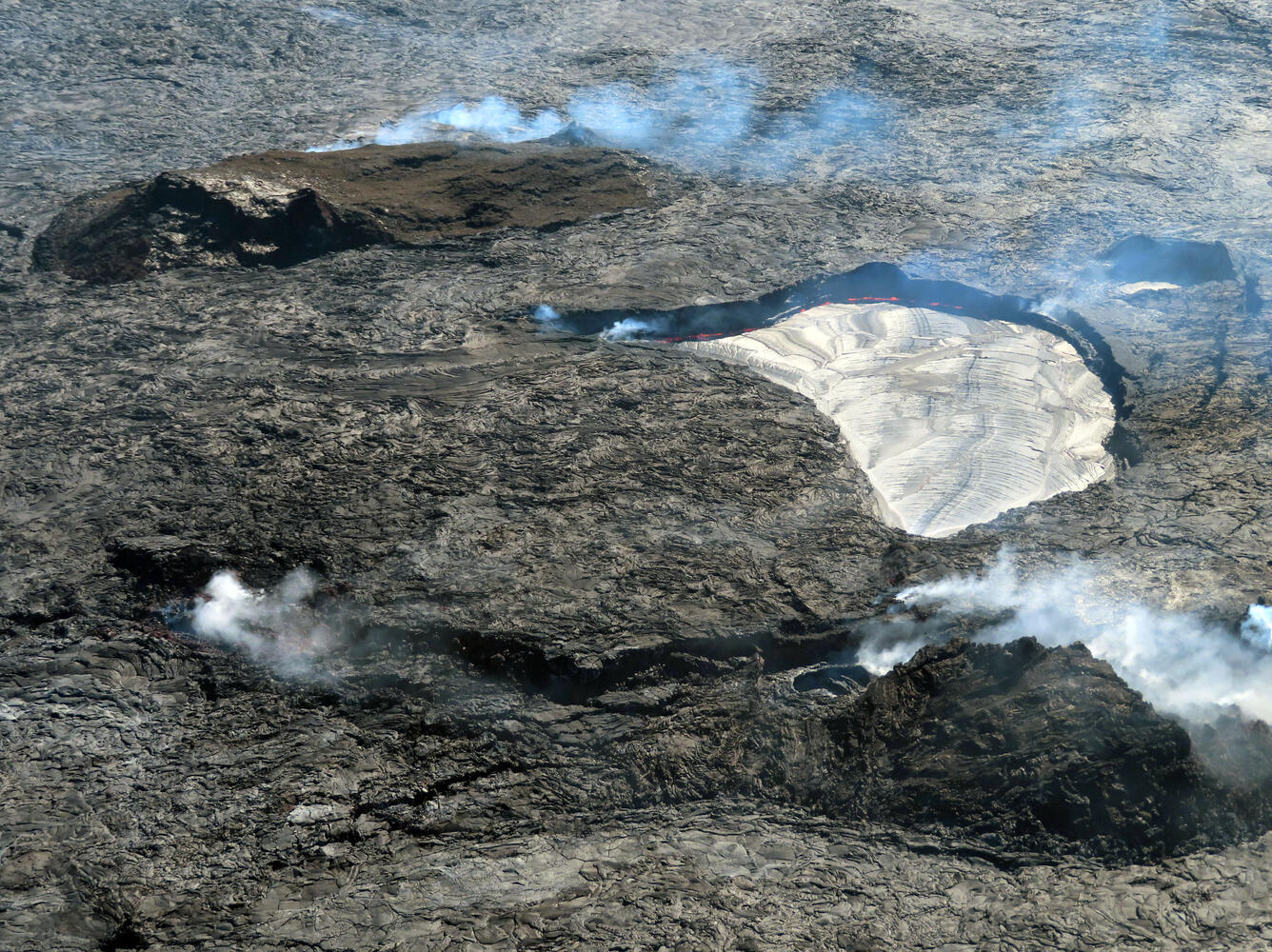
Image showing the active lava lake (silvery area), the west vent complex (lower right), and the main island (upper left) within Halema‘uma‘u crater, at the summit of Kīlauea. Orange lava can be seen spattering on the east side of the active lava lake.
Halemaʻumaʻu Lava Lake Observations:
Eruption of lava from the western vent into the active lava lake and onto the crater floor continued over the past 24 hours. The active part of the lava lake has been steady over the past 24 hours. Overflight measurements from October 28, 2022, indicated that the crater floor had seen a total rise of about 143 meters (469 feet), since the beginning of this eruption on September 29, 2021.
Summit Observations:
Summit tiltmeters recorded inflation until approximately 9 p.m. last night, when deflation (which is ongoing) began. Volcanic tremor remains above background levels. A sulfur dioxide (SO2) emission rate of approximately 500 tonnes per day (t/d) was measured on November 15, 2022.
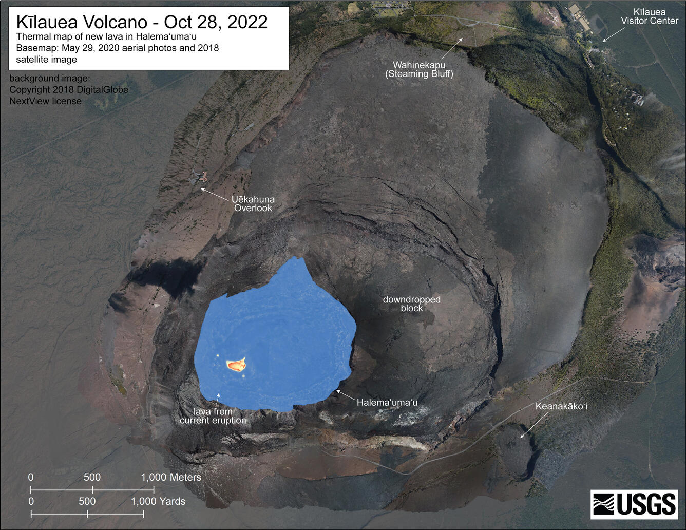
A helicopter overflight on October 28, 2022, allowed for aerial visual and thermal imagery to be collected of Halema‘uma‘u crater at the summit of Kīlauea. The active lake surface is limited to the western portion of the crater. The scale of the thermal map ranges from blue to red, with blue colors indicative of cooler temperatures and red colors indicative of warmer temperatures.
Rift Zone Observations:
No unusual activity has been noted along the East Rift Zone or Southwest Rift Zone; low rates of ground deformation and seismicity continue along both. Measurements from continuous gas monitoring stations downwind of Puʻuʻōʻō in the middle East Rift Zone remain below detection limits for SO2, indicating that SO2 emissions from Puʻuʻōʻō are negligible.
Source : HVO.
Photos : USGS / J.M. Chang ,
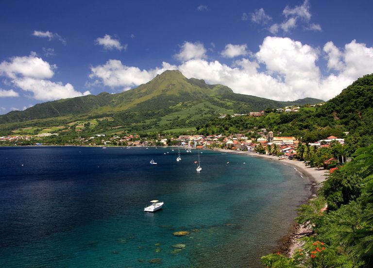
La Martinique , Mount Pelée :
Weekly report on the activity of Mount Pelée for the period from November 11, 2022 to November 18, 2022.
Between November 11, 2022 at 4 p.m. (UTC) and November 18, 2022 at 4 p.m. (UTC), the OVSM recorded at least 4 volcano-tectonic earthquakes of magnitude less than 1. Two of these low-energy earthquakes could be located. They are identical to those of the well-known families on Pelee which are located inside the volcanic edifice around 0.4 km depth above sea level or about 1 km depth below the summit. This superficial volcano-tectonic seismicity is associated with the formation of micro-fractures in the volcanic edifice. During the period of this report, the OVSM also recorded 4 hybrid-type earthquakes and 1 long-period type earthquake. These signals containing low frequencies are associated with the presence of fluids (gas, hydrothermal water) in the volcanic edifice.
None of these earthquakes was felt by the population.
During volcanic reactivation phases of volcanoes similar to Mount Pelee, periods of higher seismic activity often alternate with phases of lower seismicity. Since the reactivation of the hydrothermal-magmatic system (end of 2018), several periods of zero or weak seismicity have been recorded by the OVSM, for example May 2019 (5 earthquakes), October 2019 (3 earthquakes), August 2020 (1 earthquake) , and only 8 earthquakes between June 24 and August 8, 2022 (period of 2 months).
The areas of degraded vegetation located between Morne Plumé and the Chaude River were observed during a helicopter flight carried out on February 9 and May 5, with the support of Dragon 972, and confirmed by analysis of satellite and drone images. (overview of May 11) and satellite analysis (June 2022). A new area of degraded vegetation, located just north of the Chaude River, was observed from August 26th.
The alert level remains YELLOW: vigilance.
Source : OVSM-IPGP.
Photo : tameteo.com