November 02 , 2022.
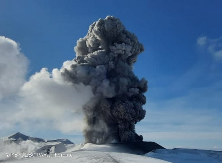
Kamchatka , Bezymianny / Ebeko :
VOLCANO OBSERVATORY NOTICE FOR AVIATION (VONA)
Issued: November 02 , 2022
Volcano: Bezymianny (CAVW #300250)
Current aviation colour code: YELLOW
Previous aviation colour code: orange
Source: KVERT
Notice Number: 2022-162
Volcano Location: N 55 deg 58 min E 160 deg 35 min
Area: Kamchatka, Russia
Summit Elevation: 2882 m (9452.96 ft)
Volcanic Activity Summary:
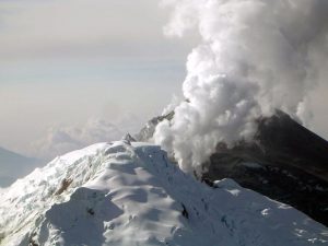
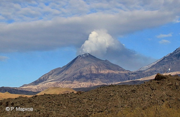
The extrusive-effusive eruption of the volcano continues, a strong fumarole activity, and sometimes an incandescence of the lava dome, and hot avalanches accompanies this process. But the activity of the volcano significantly decreased. Satellite data by KVERT showed a weak thermal anomaly over the volcano. KVERT continues to monitor Bezymianny volcano.
The extrusive-effusive eruption of the volcano continues. Ongoing activity could affect low-flying aircraft.
Volcanic cloud height:
NO ASH CLOUD PRODUSED
Other volcanic cloud information:
NO ASH CLOUD PRODUSED
Remarks:
Bezymianny volcano is the most active volcano of the world. In 1955, for the first time in history, Bezymianny started to erupt and after six months it produced a catastrophic eruption with the total volume of eruptive products over 3 km3. The lava dome began to grow in the explosive crater immediately after the catastrophe and continues at now.
—————————————————————————————————————————————–
VOLCANO OBSERVATORY NOTICE FOR AVIATION (VONA)
Issued: November 01 , 2022
Volcano: Ebeko (CAVW #290380)
Current aviation colour code: ORANGE
Previous aviation colour code: orange
Source: KVERT
Notice Number: 2022-160
Volcano Location: N 50 deg 41 min E 156 deg 0 min
Area: Northern Kuriles, Russia
Summit Elevation: 1156 m (3791.68 ft)
Volcanic Activity Summary:
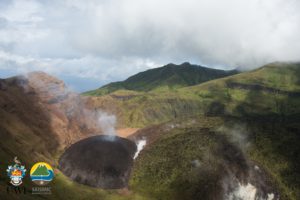
A moderate eruptive activity of the volcano continues. According to visual data by volcanologists from Severo-Kurilsk, explosions sent ash up to 2 km a.s.l., an ash cloud is drifting to the northeast of the volcano.
A moderate eruptive activity of the volcano continues. Ash explosions up to 6 km (19,700 ft) a.s.l. could occur at any time. Ongoing activity could affect low-flying aircraft and airport of Severo-Kurilsk.
Volcanic cloud height:
2000 m (6560 ft) AMSL Time and method of ash plume/cloud height determination: 20221101/2215Z – Visual data
Other volcanic cloud information:
Distance of ash plume/cloud of the volcano: 5 km (3 mi)
Direction of drift of ash plume/cloud of the volcano: NE
Time and method of ash plume/cloud determination: 20221101/2215Z – Visual data
Source : Kvert.
Photos : R. Markov , L. Kotenko. IVS FEB RAS.
Indonesia , Kerinci :
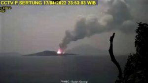
Mount Kerinci erupted on Tuesday, November 1, 2022 at 4:59 p.m. WIB with an ash column height observed at ± 200 m above the peak (± 4005 m above sea level). The ash column was observed to be grey/brown with moderate to thick intensity, trending north and northeast. This eruption was recorded on a seismograph with a maximum amplitude of 6 mm and a duration of 500 seconds.

Observation of seismicity:
It was recorded:
72 emission earthquakes with an amplitude of 0.5 to 6 mm and a duration of 10 to 29 seconds.
2 distant tectonic earthquakes with an amplitude of 25-33 mm, S-P 11-50 seconds and a duration of 108-248 seconds.
1 continuous tremor with an amplitude of 0.5 to 1 mm, dominant value 1 mm.
Source et photo : Magma Indonésie
United – States , Yellowstone :
44°25’48 » N 110°40’12 » W,
Summit Elevation 9203 ft (2805 m)
Current Volcano Alert Level: NORMAL
Current Aviation Color Code: GREEN
Recent Work and News
October saw the end of major field work in Yellowstone, including maintenance on the Norris temperature-monitoring network and the recovery of several temporary GPS stations, which are deployed every May and collected in October before the onset of winter. Field crews will continue small-scale operations until winter snows set in and make large parts of the region inaccessible.
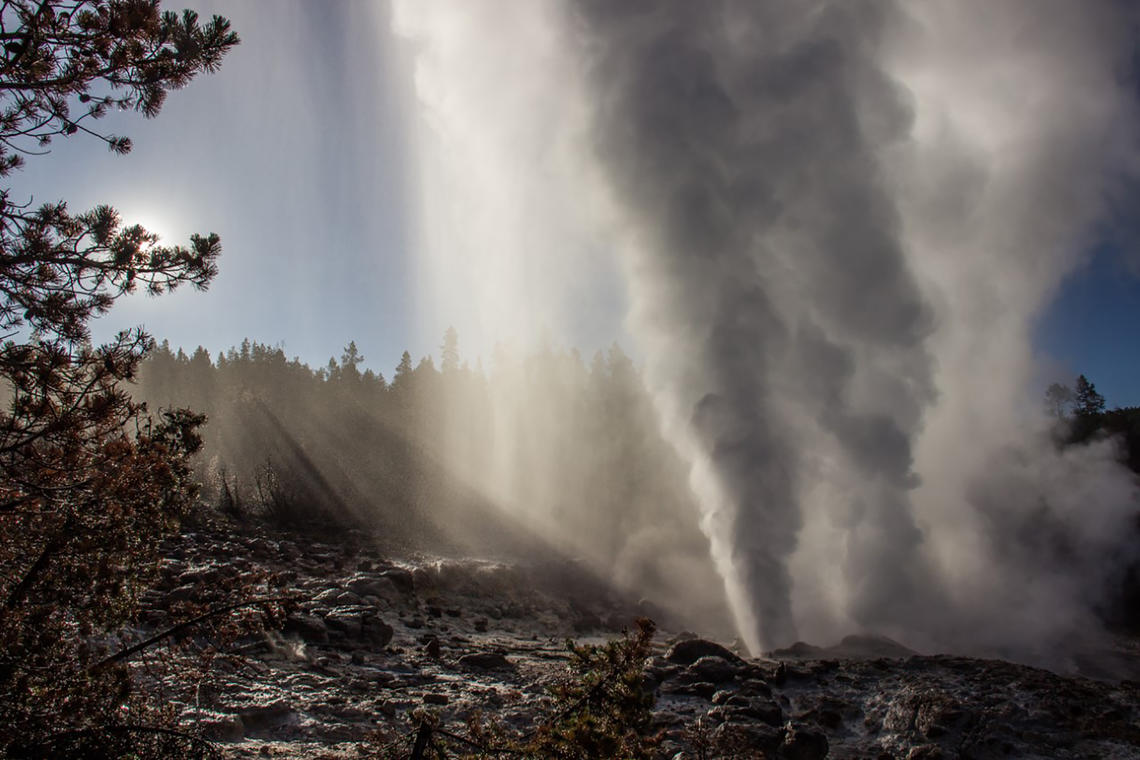
Steamboat Geyser did not experience any major water eruptions during October, and the total number of eruptions in 2022 remains at 9. Minor eruptions at the geyser resumed in mid-October after a few-week hiatus following the most recent major eruption on September 18, suggesting that another major eruption will occur in the next few days to weeks.
Seismicity
During October 2022, the University of Utah Seismograph Stations, responsible for the operation and analysis of the Yellowstone Seismic Network, located 344 earthquakes in the Yellowstone National Park region. The largest event of the month was a minor earthquake of magnitude 2.9 located about 14 miles south-southwest of Mammoth Hot Springs in Yellowstone National Park on October 13 at 5:11 AM MDT. This event is part of ongoing seismicity that began in the area on July 29. In October, 238 earthquakes were added to the sequence, and seismicity continued through the end of the month.
October seismicity was marked by two additional swarms:
1) A swarm of 27 earthquakes, ~12 miles northeast of Old Faithful in Yellowstone National Park, occurred during October 4–5, with the largest earthquake (magnitude 2.5) taking place on October 4 at 8:14 PM MDT.
2) A small swarm of 15 earthquakes, ~6 miles north of West Yellowstone, MT, occurred during October 1–2, with the largest earthquake (magnitude 2.8) recorded on October 1 at 2:39 PM MDT.
Earthquake sequences like these are common and account for roughly 50% of the total seismicity in the Yellowstone region.
Yellowstone earthquake activity is currently above background levels.
Ground Deformation
Little change in ground deformation has been recorded over the past month by continuous GPS stations in Yellowstone Caldera and near Norris Geyser Basin. Both areas hinted at a transition from slight uplift to slight subsidence (of about 1 cm, or less than an inch) in mid-September, which is a style of deformation that occurs every summer due to changes in groundwater conditions. The subsidence did not continue throughout October, however, and no net uplift or subsidence has been detected over the past month. The long-term rate of caldera subsidence since 2015 is a few centimeters (1–2 inches) per year.
Source : YVO.
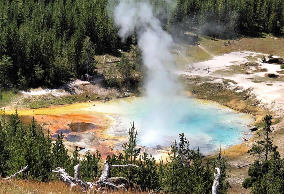
Photos : steamboat / Mara Reed , Imperial geyser / Pat Shanks.
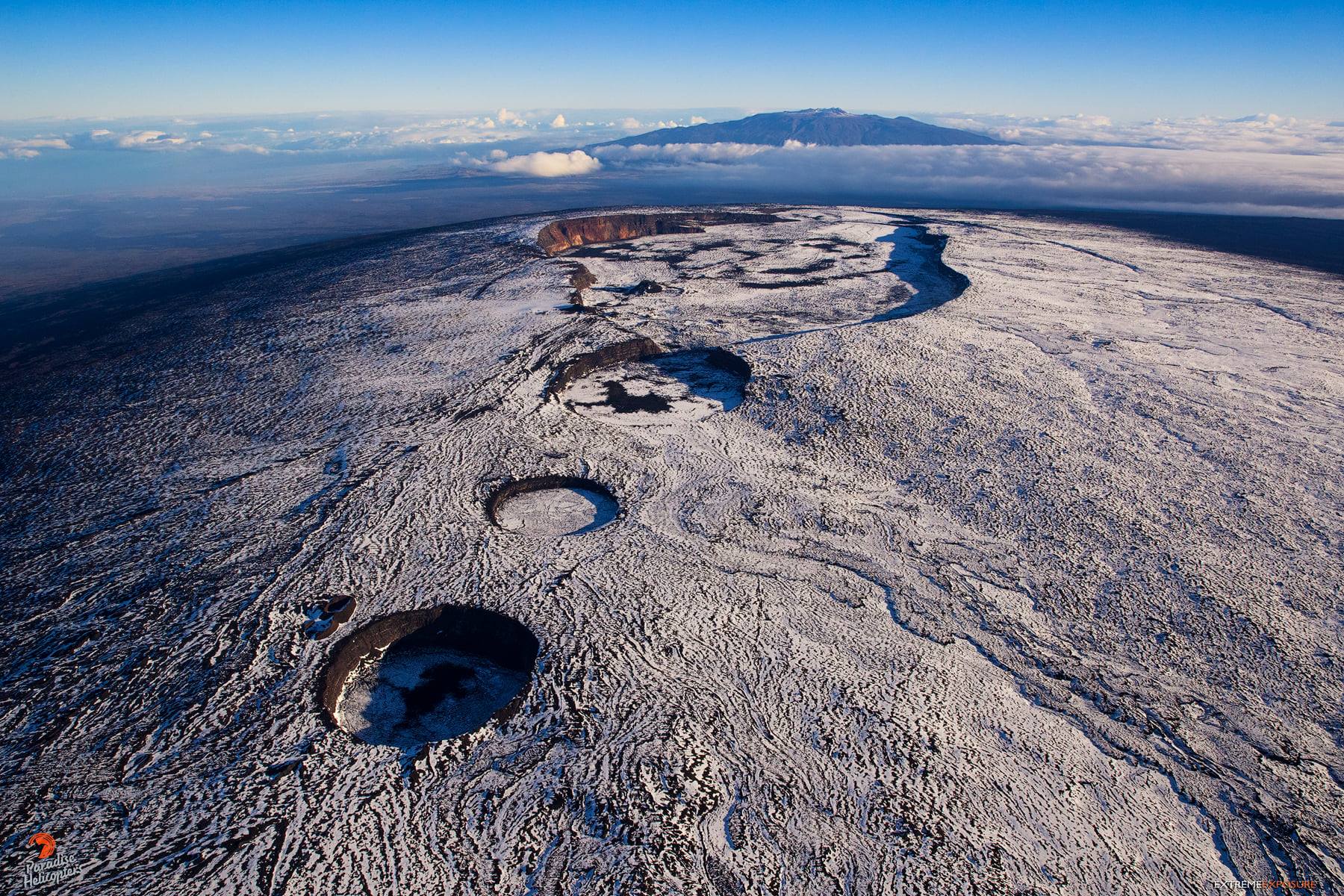
Hawaii , Mauna Loa :
19°28’30 » N 155°36’29 » W,
Summit Elevation 13681 ft (4170 m)
Current Volcano Alert Level: ADVISORY
Current Aviation Color Code: YELLOW
Activity Summary:
Mauna Loa is not erupting and there are no signs of an imminent eruption at this time. Monitoring data show no significant changes within the past 24 hours. Mauna Loa continues to be in a state of heightened unrest as indicated by increased earthquake activity and inflation of the summit. The current unrest is most likely being driven by renewed input of magma 2–5 miles (3–8 km) beneath Mauna Loa’s summit.
Observations:
During the past 24 hours, HVO detected 41 small-magnitude (below M3.0) earthquakes 2–3 miles (2–5 km) below Mokuʻāweoweo caldera and 4–5 miles (6–8 km) beneath the upper-elevation northwest flank of Mauna Loa. Both of these regions have historically been seismically active during periods of unrest on Mauna Loa.
Global Positioning System (GPS) instruments at the summit and on the flanks of Mauna Loa continue to measure inflation at rates elevated since mid-September. However, tiltmeters at the summit are not showing significant surface deformation over the past week.
Concentrations of sulfur dioxide (SO2), hydrogen sulfide (H2S), and carbon dioxide (CO2), as well as fumarole temperatures, remain stable at the summit and at Sulphur Cone on the upper Southwest Rift Zone. Webcam and thermal camera views have shown no changes to the volcanic landscape on Mauna Loa over the past week.
Source : HVO
Photo : Bruce Omori
Alaska , Pavlof :
55°25’2″ N 161°53’37 » W,
Summit Elevation 8261 ft (2518 m)
Current Volcano Alert Level: WATCH
Current Aviation Color Code: ORANGE
Low-level eruptive activity continues from a vent on the east flank of Pavlof Volcano, just below the summit. Seismic tremor and small explosions were detected in geophysical data over the past day. Low-level weak ash and steam emissions were observed in clear web camera views throughout the day to altitudes of <10,000 feet above sea level, depositing minor tephra fall on the flanks of the active vent. Moderately elevated surface temperatures were also observed in satellite imagery.
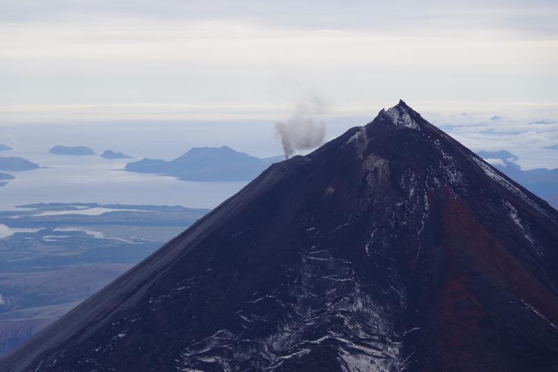
Small explosions associated with the current eruption could happen at any time and may be accompanied by small ash plumes within the immediate vicinity of the volcano. The level of unrest at Pavlof Volcano can change quickly and the progression to more significant eruptive activity can occur with little or no warning.
Pavlof Volcano is monitored by local seismic and infrasound sensors, satellite data, web cameras, and regional infrasound and lightning networks.
Source : AVO
Photo : Izbekov, Pavel