September 14 , 2022.
Italy , Stromboli :
WEEKLY BULLETIN, from September 05, 2022 to September 11, 2022. (issue date September 13, 2022)
ACTIVITY STATUS SUMMARY
In the light of the surveillance data, it is highlighted:
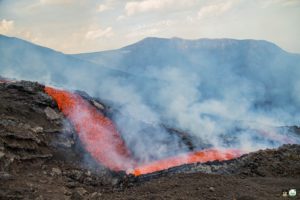
1) VOLCANOLOGICAL OBSERVATIONS: In this period a normal explosive activity of Strombolian type was observed. The total hourly frequency of explosions was variable on low values (3-5 events/h). The intensity of the explosions was low and medium in both the North Crater area and the Center-South Crater area.
2) SEISMOLOGY: The seismological parameters monitored do not show any significant variations.
3) GROUND DEFORMATIONS: The ground deformation monitoring networks in operation on the island did not show any significant variations during the period studied.
4) GEOCHEMISTRY: SO2 flux at an average and increasing level
The flux of CO2 from the soils in the summit zone is on average values.
The C/S ratio in the plume settles on average values (9.5)
Isotope ratio of dissolved Helium in heat sinks: There is no update from the July 27, 2022 sampling.
5) SATELLITE OBSERVATIONS: The thermal activity observed by satellite in the summit area was weak.
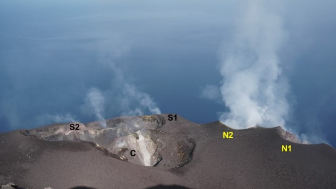
Photo of the crater terrace taken from the Pizzo sopra la fossa with the location of the crater sectors of the two crater zones (N and CS)
VOLCANOLOGICAL OBSERVATIONS
In the period under observation only an update is available concerning the volcanological field observations on Stromboli, following problems with the acquisition of signals
videos caused by damage to the optical fiber connecting Punta Labronzo and COA due to the bad weather that hit the island on August 12, 2022. The latest updated data for the period from August 8 to August 14, 2022, placed the total explosive activity at a medium-low level, with an intensity of explosions between low and medium in the areas of the North and Center-South crater.
As part of the activities of the DPC/INGV Annex A convention and the UN departmental project, 2 inspections were carried out in the summit area: on the morning of Wednesday September 7th and Friday September 9th.
Eruptive activity was observed from the Roccette shelters to the Ginostra shelters, passing through the Elipista and the Pizzo. Overall activity was low both in terms of the type and intensity of explosions and the number of events.
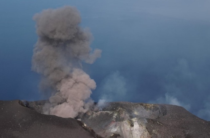
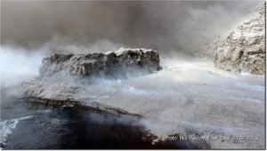
Photo of an ash emission from the S2 mouth.
In the Center-South zone, the degassing was very weak, although it was more evident on Friday 9 when the crater S1 and that located between S1 and S2 also produced a light and discontinuous degassing. Weak and infrequent (sometimes simultaneously) ash emissions were observed from at least 2 vents located near the S2 crater, sometimes associated with little coarse material. At the central crater (C) degassing was almost absent; the accumulation of collapsed material inside the upper edge of the wall facing the Pizzo was clearly visible.
In the North zone, the N2 crater showed very intense degassing with discontinuous jets of very noisy gas, and modest but rare explosions of lava shreds. The N1 crater showed very little degassing in general on both days, although episodic ash emissions were observed on Friday 9.
Source : INGV.
Photos : Capture web ingv.it
Italy , Vulcano :
WEEKLY BULLETIN, from September 05, 2022 to September 11, 2022. (issue date September 13, 2022)
ACTIVITY STATUS SUMMARY
In the light of the surveillance data, it is highlighted:
1) Temperature of the crater fumaroles: Along the upper edge, temperatures remain stable at high values.
2) CO2 flux in the crater area: The CO2 flux in the crater area shows a slight decrease, still remaining on medium-high values.
3) SO2 flux in the crater area: stable SO2 flux at a moderately medium-high level
4) Geochemistry of fumarolic gases: No update is available.
5) CO2 fluxes at the base of the La Fossa cone and in the Vulcano Porto area: CO2 flux values stable and above the background of the Rimessa site. At the Camping Sicilia site there is a slight downward trend, while at the Palizzi site (P4max) there is a slight increase in flows, in both sites they remain high. On the Faraglione site, the values recorded are stable and close to background noise.
6) Geochemistry of the thermal aquifers: In the waters of the well of Camping Sicilia there are always high temperature values and medium-low conductivity values; in the Bambara well, the level values show a further decrease, while the conductivity values show an upward trend.
7) Local seismicity: low occurrence rate of local events.
8) Regional seismicity: No regional seismic activity.
9) Deformations – GNSS: The network of permanent GNSS stations has not recorded any significant changes
10) Deformations – Inclinometry: The inclinometric network does not record any significant variations
11) Gravimetry: High frequency anomalies are recorded on September 7 and 8. There are no obvious medium-long term variations.
12) Other Notes: Mobile GNSS. The GNSS mobile network acquires and transmits movements in real time at a frequency of 1 Hz. The historical series acquired so far do not show significant variations around the Porto di Levante area.
CO2 FLOW IN THE CRATER AREA
The data from the VSCS station show a slight drop and settle in any case on values around 6436 g/m2/day (day September 12). The monthly average for September is 8037 g/m2/day, a slight decrease compared to August (8151 g/m2/day) but still abnormal compared to the average values of the background assessed over the last decade of observations and feedback .
LOCAL SEISMICITY
Seismic activity related to high-frequency events was low, with less than five events per day.
Regarding the number of VLP events, the slow downward trend continues. In the week of September 5-11, an average of about 5 events per day.
Source : INGV.
Photos : INGV-Roma1
New Zealand , Lake Taupo :
VOLCANIC ACTIVITY BULLETIN , Wed Sep 14 2022 12:00 AM;
Volcanic Alert Level remains at 0
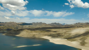
The earthquake sequence beneath Lake Taupō continues, now including a magnitude 4.2 event at 6.36 am on Saturday 10 September 2022 – the largest earthquake in the area to date this year. The earthquake was located on the east side of the lake at a depth of approximately 5 km and was widely felt locally. The Volcanic Alert Level for Taupō Volcanic Centre remains at Level 0.

Figure 1: Earthquakes located by GeoNet in the Lake Taupō area from January 1 to September 12, 2022. All earthquakes shown here were located less than 30 km deep. There are over 650 earthquakes shown on the map
The earthquake sequence beneath the central part of Lake Taupō (Taupō-nui-a-Tia), that we reported on in our previous two Volcanic Activity Bulletins, has continued at a rate of ~40-50 earthquakes per week. Since the start of the sequence in May 2022 the rate has increased from 30 events per week to more than 40 per week. We have now located over 650 earthquakes at less than 30 km depth.
The M 4.2 earthquake on Saturday morning is the largest event this year at Taupō. It was reported felt by 1242 people. The next two largest earthquakes were both magnitude 3.6; the first was recorded on 17 May and the other on 11 July 2022. Since 2000 we have located 7 earthquakes larger than magnitude 4 under the lake, the largest was a M 5.0 on 4 September 2019 located near Motutaiko Island. Saturday’s earthquake was 8 km to the northeast of that 2019 earthquake.
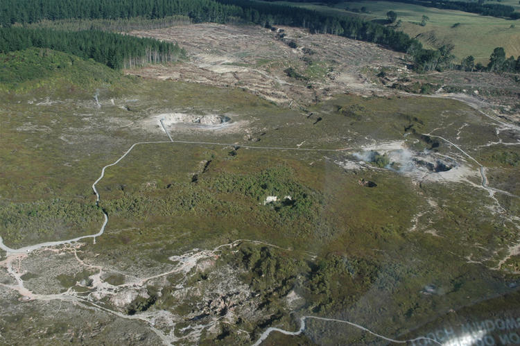
Figure 1 shows that earthquake locations in this year’s sequence are forming three clusters in the central part of the lake. There is a smaller, western cluster centred just offshore from Karangahape Cliffs, then a cluster in the central lake area and the larger eastern cluster that partly wraps around the central cluster. Figure 1 also shows clusters of small earthquakes at geothermal fields in the Taupo area. The magnitudes and numbers of events in the clusters are typical of the ongoing pattern of seismicity. Shown in Figure 2 is the number of earthquakes detected and located each year since 2000 in the dashed area outlined in the map.
In addition to seismic activity, GeoNet continuously monitors ground deformation about Taupō. Further to the 12 mm uplift seen from lake levelling data, deformation data from GNSS (GPS) instruments around the lake also show a signal indicating horizontal deformation. Numerical modelling indicates that the horizontal extension is consistent with a deformation source within the main region of seismic activity.

Figure 2: Earthquakes detected and located in the dashed area outlined in the map each year since 2000. The 2022 sequence of earthquakes stands out, at this stage numbers exceed sequences in 2009, are near equal to those in 2008, and remain less than those in 2019.
Taupō Volcanic Centre is part of the Taupō Volcanic Zone, a tectonically very active region with many known faults and active volcanism. Activity in this region is often related to a mix of regional deformation processes and the separate magmatic systems under the volcanoes, which has helped to inform our view that Volcanic Alert Level 0 is currently appropriate for the Taupō Volcanic Centre. Therefore, the Volcanic Alert Level remains at 0.
Source : Geonet.
Photos : Geonet ( ( crater of the moon).
Indonesia , Semeru :
EARTHQUAKE OBSERVATION
17 earthquake eruptions/explosions with an amplitude of 11-22 mm, and duration of 75-110 seconds.
VOLCANO OBSERVATORY NOTICE FOR AVIATION – VONA
Issued : September 12 , 2022
Volcano : Semeru (263300)
Current Aviation Colour Code : ORANGE
Previous Aviation Colour Code : orange
Source : Semeru Volcano Observatory
Notice Number : 2022SMR207
Volcano Location : S 08 deg 06 min 29 sec E 112 deg 55 min 12 sec
Area : East java, Indonesia
Summit Elevation : 11763 FT (3676 M).

Volcanic Activity Summary :
Eruption with volcanic ash cloud at 22h24 UTC (05h24 local).
Volcanic Cloud Height :
Best estimate of ash-cloud top is around 12723 FT (3976 M) above sea level, may be higher than what can be observed clearly. Source of height data: ground observer.
Other Volcanic Cloud Information :
Ash-cloud moving to west
Source : Magma Indonésie .
Photo : Archive Magma Indonésie
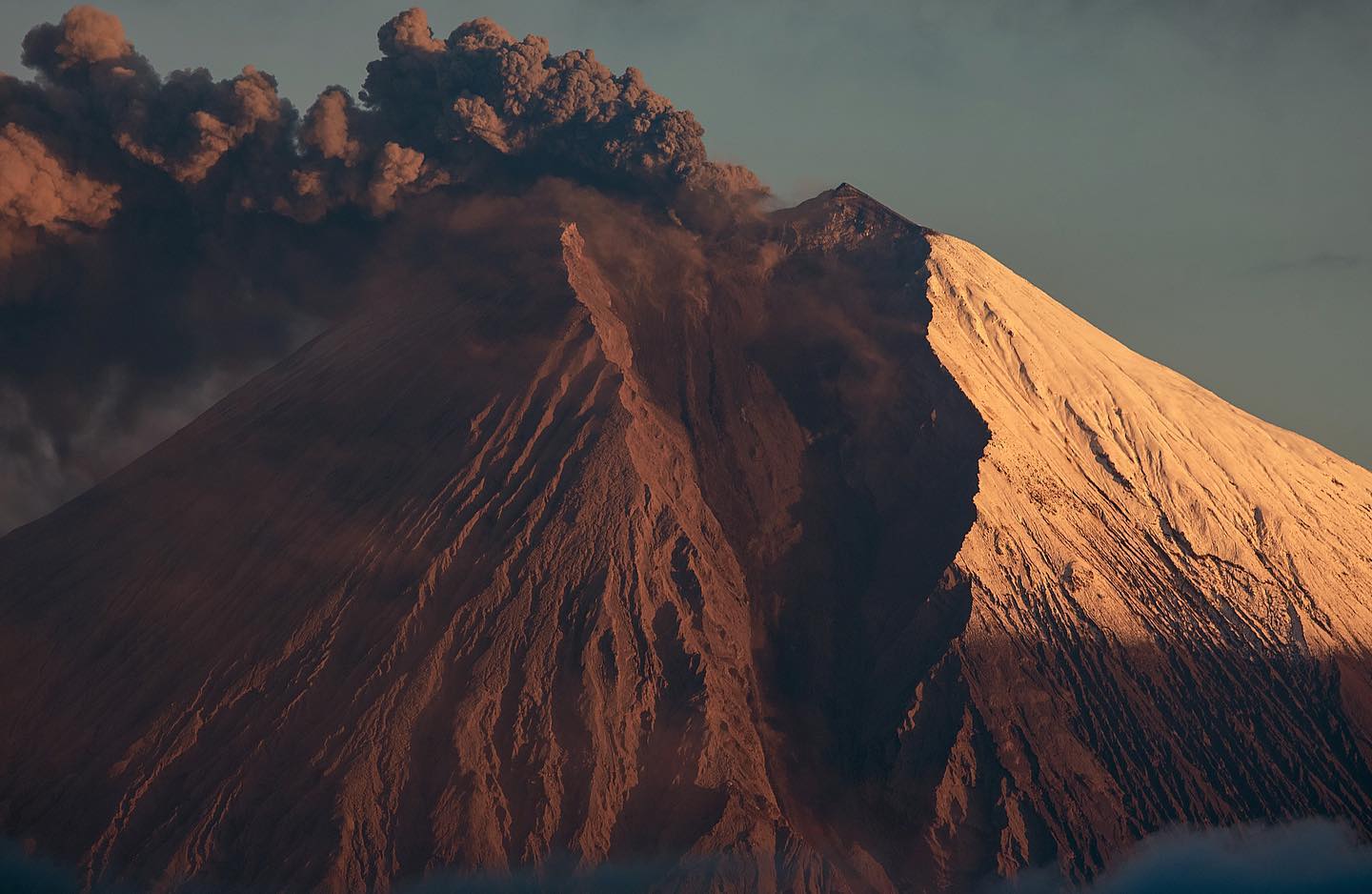
Ecuador , Sangay :
TUESDAY SEPTEMBER 13, 2022
From 15:20 TL, through satellite images (GOES-16), a thin cloud of ash can be seen reaching 1.4 km above the crater and heading northwest. The ash cloud could cause a slight ash fall in the province of Chimborazo. This phenomenon has been recurrent throughout the current eruption period. It is recommended to take appropriate action.
DAILY REPORT OF THE STATE OF SANGAY VOLCANO, Tuesday September 13, 2022.
Information Geophysical Institute – EPN.
Surface Activity Level: High, Surface Trend: No change.
Internal activity level: High, Internal trend: No change.
Seismicity: From September 12, 2022. , 11:00 a.m. to September 13, 2022, 11:00 a.m.:
There were no cuts in the transmission of data from the reference station, so the seismic statistics are complete.
Explosion (EXP) 705
Long Periods (LP) 32
Emission Tremors (TREMI ) 28.
Rains / Lahars:
No rain has been recorded in the area in the past 24 hours. **In the event of heavy rains, these could remobilize the accumulated materials, generating mudslides and debris that would descend on the flanks of the volcano and flow into the adjacent rivers.**
Emission / ash column:
According to the cameras, several gas and ash emissions were observed at heights of 1,500 to 2,000 meters above the level of the crater to the west and southwest. The Washington VAAC recorded 5 ash emission alerts observed on satellites at heights of 1,200 and 2,100 meters above crater level in a constant westerly direction.
Other Monitoring Parameters:
The FIRMS satellite system recorded 35 thermal alerts, while the MIROVA satellite system recorded 2 high thermal alerts (375 and 307 MW) on the Sangay in the last 24 hours.
Observation:
In the images shared by the Network of Volcanic Observers (ROVE), ECU911 and the cameras of the Institute, several emissions of gas and ash could be observed which did not generate any news. As of the closing date of this bulletin, there have been no nationwide ashfall reports. At the moment, the volcano is cloudy.
Alert level: Orange.
Source : IGEPN.
Photo : #Eqphos_fotografía