September 02 , 2022.
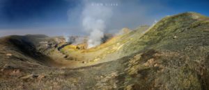
La Réunion , Piton de la Fournaise :
Monthly Bulletin – August 2022.
Seismicity:
In August 2022, the OVPF-IPGP recorded at the level of the Piton de la Fournaise massif in total:
• 212 superficial volcano-tectonic earthquakes (0 to 2.5 km above sea level) under the summit craters;
• 5 deep earthquakes (below sea level);
• 353 landslides (in the Cratère Dolomieu, the ramparts of the Enclos Fouqué and the Piton de Crac, and the Rivière de l’Est).
The period from August 1 to 27, 2022 was marked by low seismicity at the level of Piton de la Fournaise with an average of 3 superficial volcano-tectonic earthquakes per day.
Since August 28, 2022 an increase in seismicity has been observed under the Piton de la Fournaise. 20 volcano-tectonic earthquakes were recorded on August 28, 24 on August 29, 41 on August 30 and 31 on August 31.
Some events have been located under the eastern edge of the Dolomieu crater at about 500 m above sea level but most events are of too low magnitude to be localized. A few deep earthquakes under the summit and eastern flank of Piton de la Fournaise have also been identified.
The number of landslides (in the Cratère Dolomieu, the ramparts of the Enclos Fouqué and at the broken of the Rivière de l’Est) is down sharply compared to the previous month, 353 events against 1178 in July. The majority of the collapses and the most important take place in the area of the broken Rivière de l’Est.
Deformation
After the end of the last eruption, on January 17, 2022, a slight recovery in peak inflation was recorded. This, after accelerating in mid-April, stopped in mid-May before resuming in early June at a relatively low rate.
This inflation continued in August.
This inflation is linked to a weak pressurization of the superficial magmatic reservoir located at about 1.5-2 km depth.
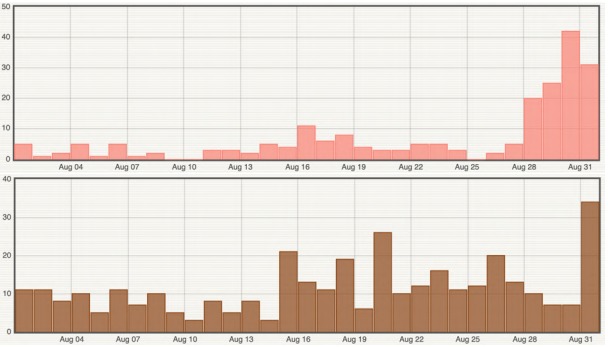
Histogram representing the number of superficial volcano-tectonic earthquakes (top) and landslides (bottom) per day recorded in August 2022 (© OVPF-IPGP)
Geochemistry of gases.
CO2 concentration in the soil.
Following the eruption of December 2020, a continuous increase in CO2 emissions from the ground is recorded at the level of the distal sites (Plaine des Cafres sectors) but also proximal (Gîte du volcan).
The last eruption took place from December 22, 2021 to January 17, 2022. From December 27, 2021, the eruption was associated with a rapid and unprecedented increase in CO2 emissions from the ground on the station proximal to the Gîte and a trend reversal on the distal stations.
The inversion observed at the distal stations lasted until January 7, 2022, then the concentrations remained stable at intermediate values until the end of January.
On the site proximal to the Gîte, a sharp drop in fluxes with very low CO2 values was detected after January 3, 2022.
At the end of the eruption a new phase of increase was recorded, but with a lower rate. The strong fluctuations observed during the month of February are certainly linked to environmental influences due to two cyclonic events.
Source : OVPF
Photos : G Vitton , OVPF.
Colombia , Nevado del Ruiz :
Bulletin of activity level of the Nevado del Ruiz volcano.
The activity level continues at the Yellow Activity Level or (III): changes in the behavior of volcanic activity.
Regarding the monitoring of the activity of the Nevado del Ruiz volcano, the COLOMBIAN GEOLOGICAL SERVICE reports that:
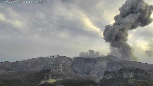
Seismicity related to fluid dynamics inside volcanic conduits showed a decrease in the number of recorded earthquakes and released seismic energy, compared to the previous week. In general, the seismic signals associated with this process maintained moderate energy levels and were located in the Arenas crater. Thanks to the cameras installed in the area of the volcano and the report of the officials of the National Natural Park of Los Nevados, in the region, the emissions of gas and ash associated with some of these seismic signals have been confirmed. Similarly, significant changes were observed in the relative temperature of the material observed in the gas and ash columns.
It is important to mention that in the last hours several seismic signals of moderate energy level associated with gas and ash emissions have been recorded, including a confirmation report of ash fall in the municipalities of Villamaría and Manizales.
Seismicity associated with rock fracturing showed an increase in the number of earthquakes recorded and seismic energy released, compared to the previous week. There is an increase in this type of seismic activity recorded since August 28 at 11:00 p.m. in the South-South-West and North-West sectors about 4.0 km from the Arenas crater, with a notable decrease in the last hours. . Seismicity was also recorded in the Arenas crater and, to a lesser extent, in the Southeast sector. The depth of the earthquakes varied between 1.0 and 8.0 km. The maximum magnitude recorded during the week and during the rise in activity was 3.3 ML (Local Magnitude), corresponding to the earthquake of August 28 at 11:41 p.m. (local time), located 3.0 km south- Southwest of the Arenas crater at 4.0 km depth.
Deformation of the volcanic surface continues to show minor changes.
By monitoring the thermal activity of the volcano, the various web portals have reported several thermal anomalies in the Arenas crater, of low energy level.
The column of gas and steam reached a height of 2000 meters measured at the top of the volcano on August 25.
The authorities of the departments of Caldas, Tolima, Risaralda, Quindío and Cundinamarca are invited to take extreme measures focused on knowledge and risk reduction processes, as well as disaster management as preparedness measures for the future activity of the volcano Nevada del Ruiz.
Source : SGC.
Photo : SGC /la patria.
United States , Yellowstone :
44°25’48 » N 110°40’12 » W,
Summit Elevation 9203 ft (2805 m)
Current Volcano Alert Level: NORMAL
Current Aviation Color Code: GREEN
Recent Work and News
Yellowstone Volcano Observatory scientists have a busy month of work planned for September. In addition to the typical late summer maintenance of the seismic and deformation monitoring networks, new gas monitoring equipment will be installed at the existing Multi-GAS continuous site in the Mud Volcano area. A number of YVO and academic scientists will also visit the new thermal area near Tern Lake to collect gas samples and study tree-growth patterns to better understand the development of hydrothermal activity at the site. Finally, a temporary deployment of geophysical sensors throughout the park is planned to map subsurface geological conditions and fluid pathways.
Steamboat Geyser did not erupt during the month of August (the most recent eruption occurred on June 20). There have been 8 major water eruptions of the geyser in 2022.
Seismicity
During August 2022, the University of Utah Seismograph Stations, responsible for the operation and analysis of the Yellowstone Seismic Network, located 290 earthquakes in the Yellowstone National Park region. The largest event of the month was a minor earthquake of magnitude 3.1 located about 15 miles south-southwest of Mammoth Hot Springs in Yellowstone National Park on August 25 at 11:51 PM MDT. This event is part of ongoing seismicity that began July 29—221 of the August earthquakes occurred as part of this swarm, and seismicity continued into September.
Earthquake sequences like these are common and account for roughly 50% of the total seismicity in the Yellowstone region.
An earthquake of magnitude 3.3 occurred on the local night of August 31 near Lewis Lake, in the south part of Yellowstone National Park. Because this event occurred on September 1 in the UTC time zone (which is used by seismologists to define the month boundaries), it will be covered in next month’s update.
Yellowstone earthquake activity remains at background levels.
Ground Deformation
Continuous GPS stations in Yellowstone Caldera and near Norris Geyser Basin recorded about a centimeter of uplift (about half an inch) since the start of summer. This deformation is a result of snowmelt that percolates into the ground and causes the surface to swell slightly, like a sponge. The same summer-only signal is detected annually and is superimposed on the overall trend of caldera subsidence, which has been ongoing since 2015 at a rate of a few centimeters (1–2 inches) per year.
Source : YVO.
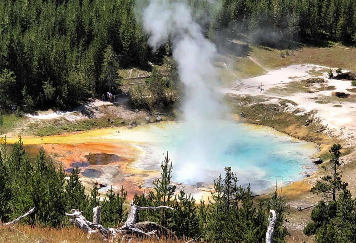
Photo : Pat Shanks. ( Imperial Geyser)
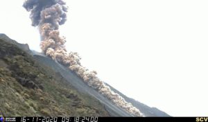
Kamchatka , Sheveluch :
VOLCANO OBSERVATORY NOTICE FOR AVIATION (VONA)
Issued: September 02 ,2022
Volcano: Sheveluch (CAVW #300270)
Current aviation colour code: ORANGE
Previous aviation colour code: orange
Source: KVERT
Notice Number: 2022-98
Volcano Location: N 56 deg 38 min E 161 deg 18 min
Area: Kamchatka, Russia
Summit Elevation: 3283 m (10768.24 ft), the dome elevation ~2500 m (8200 ft)
Volcanic Activity Summary:
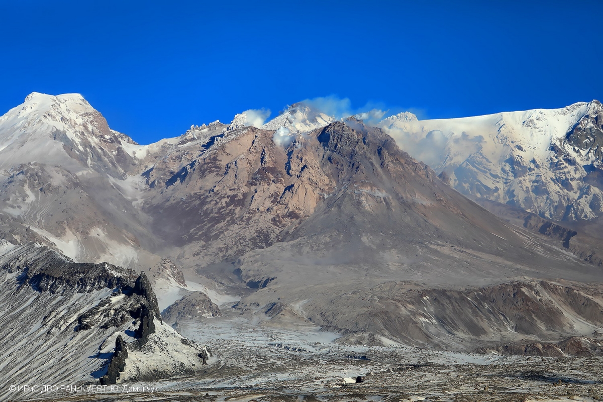
A growth of the lava dome continues, a strong fumarolic activity, and an incandescence of the lava dome, explosions, and hot avalanches accompanies this process. Video and satellite data showed a gas-steam plume containing some amount of ash extending 42 km to the north-east from the volcano.
The extrusive eruption of the volcano continues. Ash explosions up to 10-15 km (32,800-49,200 ft) a.s.l. could occur at any time. Ongoing activity could affect international and low-flying aircraft.
Volcanic cloud height:
4500 m (14760 ft) AMSL Time and method of ash plume/cloud height determination: 20220902/0245Z – Video data
Other volcanic cloud information:
Distance of ash plume/cloud of the volcano: 42 km (26 mi)
Direction of drift of ash plume/cloud of the volcano: NE / azimuth 55 deg
Time and method of ash plume/cloud determination: 20220902/0150Z – Himawari-8 14m15
Source : Kvert.
Photo : Yu. Demyanchuk, IVS FEB RAS, KVERT
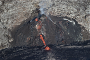
Hawaii , Kilauea :
19°25’16 » N 155°17’13 » W,
Summit Elevation 4091 ft (1247 m)
Current Volcano Alert Level: WATCH
Current Aviation Color Code: ORANGE
Activity Summary:
The summit eruption of Kīlauea Volcano, within Halemaʻumaʻu crater, continued over the past 24 hours. All recent eruptive activity has been confined to the crater. No significant changes have been observed at the summit or in either rift zone.
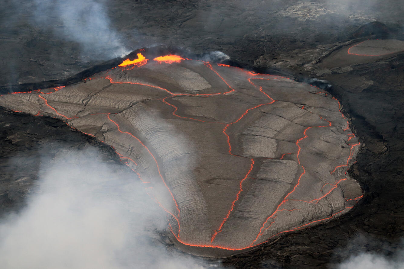
Halemaʻumaʻu Lava Lake Observations:
Eruption of lava from the western vent into the active lava lake and onto the crater floor continued over the past 24 hours. The active part of the lava lake showed continuous surface activity. A small ooze-out occured on the western crater floor margin. Overflight measurements from August 16, 2022, indicated that the crater floor had seen a total rise of about 137 meters (449 feet), and that 104 million cubic meters (27.5 billion gallons) of lava had been effused since the beginning of this eruption on September 29, 2021.
Summit Observations:
Summit tiltmeters recorded relatively little ground deformation over the past 24 hours. Volcanic tremor remains above background levels. A sulfur dioxide (SO2) emission rate of approximately 1,400 tonnes per day (t/d) was measured on August 26, 2022.
Rift Zone Observations:
No unusual activity has been noted along the East Rift Zone or Southwest Rift Zone; low rates of ground deformation and seismicity continue along both. Measurements from continuous gas monitoring stations downwind of Puʻuʻōʻō in the middle East Rift Zone remain below detection limits for SO2, indicating that SO2 emissions from Puʻuʻōʻō are negligible.
Source : HVO.
Photo : USGS / M. Patrick