August 28 , 2022.
Russia / Kuril Islands , Ebeko :
VOLCANO OBSERVATORY NOTICE FOR AVIATION (VONA)
Issued: August 28 , 2022 .
Volcano: Ebeko (CAVW #290380)
Current aviation colour code: ORANGE
Previous aviation colour code: orange
Source: KVERT
Notice Number: 2022-96
Volcano Location: N 50 deg 41 min E 156 deg 0 min
Area: Northern Kuriles, Russia
Summit Elevation: 1156 m (3791.68 ft)
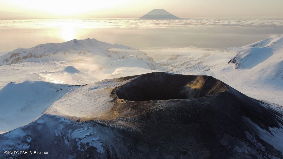
Ebeko volcano crater on 16 April, 2022. Alaid volcano on the background.
Volcanic Activity Summary:
A moderate eruptive activity of the volcano continues. According to visual data by volcanologists from Severo-Kurilsk, an explosion sent ash up to 2.0 km a.s.l., an ash cloud is drifting to the north-east of the volcano.
This activity persists. Ash explosions up to 6 km (19,700 ft) a.s.l. could occur at any time. Ongoing activity could affect low-flying aircraft and airport of Severo-Kurilsk.
Volcanic cloud height: 2000 m (6560 ft) AMSL Time and method of ash plume/cloud height determination: 20220828/0502Z – Visual data
Other volcanic cloud information:
Distance of ash plume/cloud of the volcano: 5 km (3 mi)
Direction of drift of ash plume/cloud of the volcano: ENE / azimuth 70 deg
Time and method of ash plume/cloud determination: 20220828/0502Z – Visual data
Source : Kvert.
Photo : A. Bichenko, KB GS RAS.
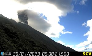
Indonesia , Dukono :
The volcano is clearly visible until it is covered by fog. Smoke from the crater is white with low to medium high intensity about 100-150 meters above the summit. The weather is sunny to cloudy, the wind is light to moderate from the West and North-West.
SEISMICITY OBSERVATION:
-10 deep volcanic earthquakes with an amplitude of 4-28 mm, and a duration of 19-29 seconds.
2 local tectonic earthquakes with an amplitude of 8-12 mm, and a duration of 37 seconds.
5 distant tectonic earthquakes with an amplitude of 12-20 mm, and a duration of 43-88 seconds.
1 continuous tremor with an amplitude of 0.5 to 2 mm, dominant value 1 mm.
VOLCANO OBSERVATORY NOTICE FOR AVIATION – VONA
Issued : August 28 , 2022
Volcano : Dukono (268010)
Current Aviation Colour Code : ORANGE
Previous Aviation Colour Code : unassigned
Source : Dukono Volcano Observatory
Notice Number : 2022DUK01
Volcano Location : N 01 deg 41 min 35 sec E 127 deg 53 min 38 sec
Area : North Maluku, Indonesia
Summit Elevation : 3933 FT (1229 M)
Volcanic Activity Summary :
Eruption with volcanic ash cloud at 21h31 UTC (06h31 local).
Volcanic Cloud Height :
Best estimate of ash-cloud top is around 7133 FT (2229 M) above sea level, may be higher than what can be observed clearly. Source of height data: ground observer.
Other Volcanic Cloud Information :
Ash-cloud moving to west
Remarks :
Eruption and ash emission is continuing
Source : Magma Indonésie .
Photo : PGA.
Costa Rica , Turrialba / Poas / Rincon de la Vieja :
Turrialba Volcano
Latitude: 10.025
Longitude:-83.767
Altitude: 3,325 meters
Observed activity:
No volcanic eruption or tremor is recorded. Low frequency volcanic earthquakes are recorded in less quantity than in previous weeks. The fumaroles inside the crater remain active. No change is recorded in the emission of volcanic gases, SO2 gas measurements remain stable at less than 10 parts per million. Since August 24, no particle of volcanic origin has been recorded at the Coronado station, which measures aerosols and gases in the environment. The volcanic edifice remains with a slight extension and subsidence.
Environmental conditions:
Cloudy conditions at the summit with winds blowing from the West-South-West.
Activity Level: Warning (2)
Poas Volcano
Latitude: 10.2
Longitude:-84.233
Altitude: 2,687 meters
Observed activity:
No eruptions recorded. A very weak tremor of fluctuating amplitude, broad spectrum and dominant frequency of 4.6 Hz is recorded. Low frequency and very low amplitude volcanic earthquakes are recorded, in fewer numbers than those recorded in previous weeks. The fumaroles show low activity. The measured CO2/SO2 gas ratio shows a slight increase, while the measured SO2 gas remains stable at less than 5 parts per million. The measurement of SO2 gas at the Mirador does not exceed the value of 2 parts per million. No significant deformation of the volcanic edifice is recorded with the GNSS instruments.
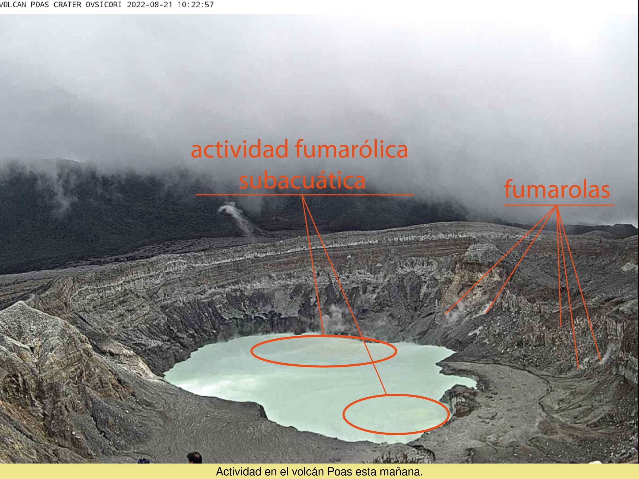
Environmental conditions:
The summit remains clear with high clouds. The winds are heading southwest.
Activity Level: Warning (2)
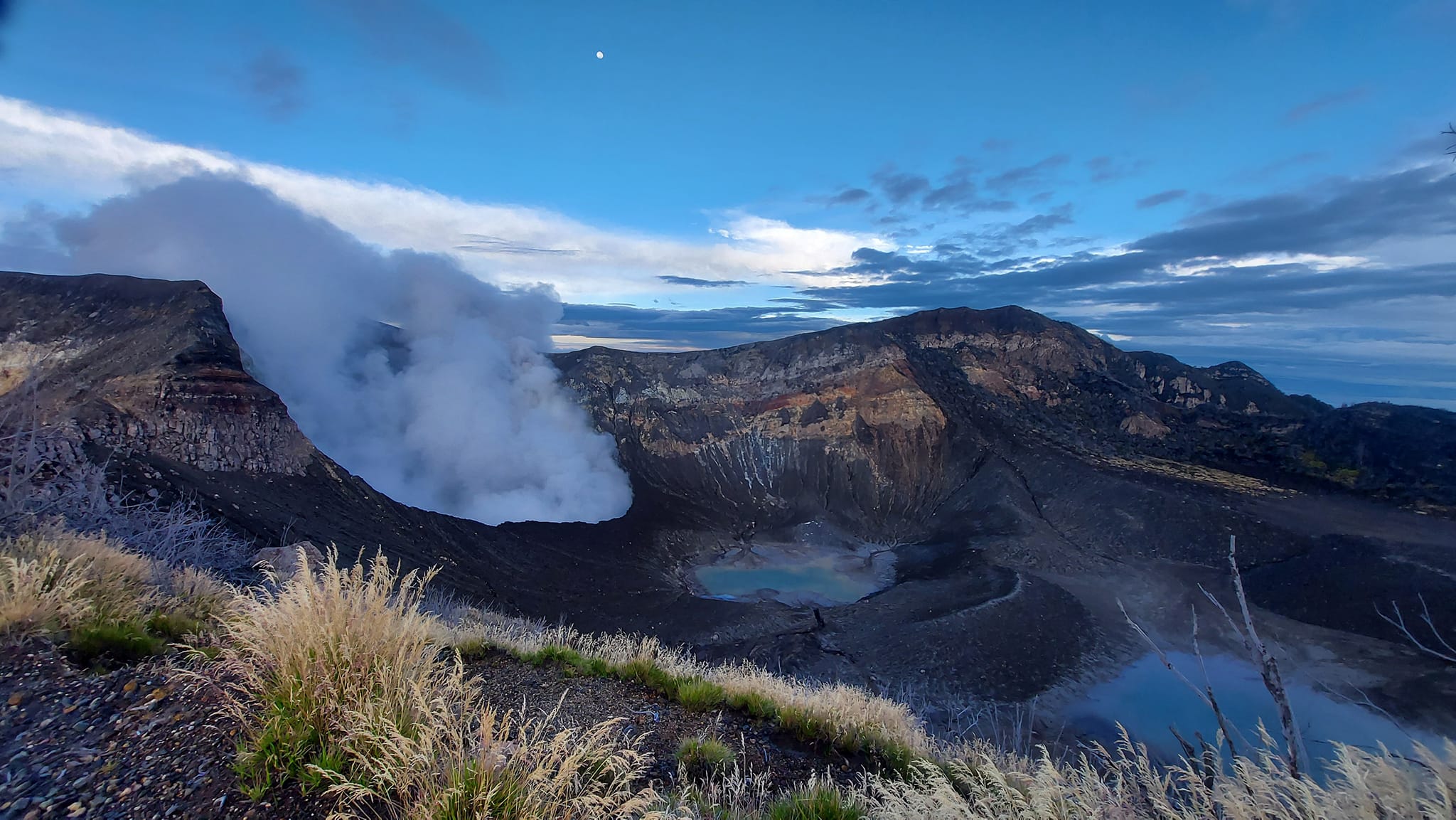
Rincon de la Vieja Volcano
Latitude: 10.83
Longitude:-85.324
Altitude: 1,916 meters
Observed activity:
No eruption reported. A weak tremor with a broad spectrum and a dominant frequency of 2.2 Hz is recorded. Few low frequency and low amplitude volcanic earthquakes are recorded, mainly of the « tornillos » type. The fumaroles inside the crater remain active, with plumes rising more than 100 meters above the crater in the absence of wind. SO2 gas emission remains low, with discrete peaks during degassing episodes. The GNSS instruments do not register any significant deformation.

Conditions environnementales:
Le sommet reste nuageux et les vents soufflent au Sud-Ouest.
Niveau d’activité : Avertissement (2)
Source : Ovsicori .
Photos : Parque Nacional , Ovsicori / Mauricio Guttierez
Hawaii , Mauna Loa :
19°28’30 » N 155°36’29 » W,
Summit Elevation 13681 ft (4170 m)
Current Volcano Alert Level: ADVISORY
Current Aviation Color Code: YELLOW
Activity Summary:
Mauna Loa Volcano is not erupting. Rates of seismicity remain slightly elevated above long-term background levels. Other Mauna Loa monitoring data streams—ground deformation, gas concentrations, visual appearance in webcams—show no significant changes.
Observations:
During the past week, HVO seismometers recorded approximately 118 small-magnitude (below M3.0) earthquakes below the summit and upper-elevation flanks of Mauna Loa. The majority of these earthquakes occurred at shallow depths less than 15 kilometers (9 miles) below sea level.
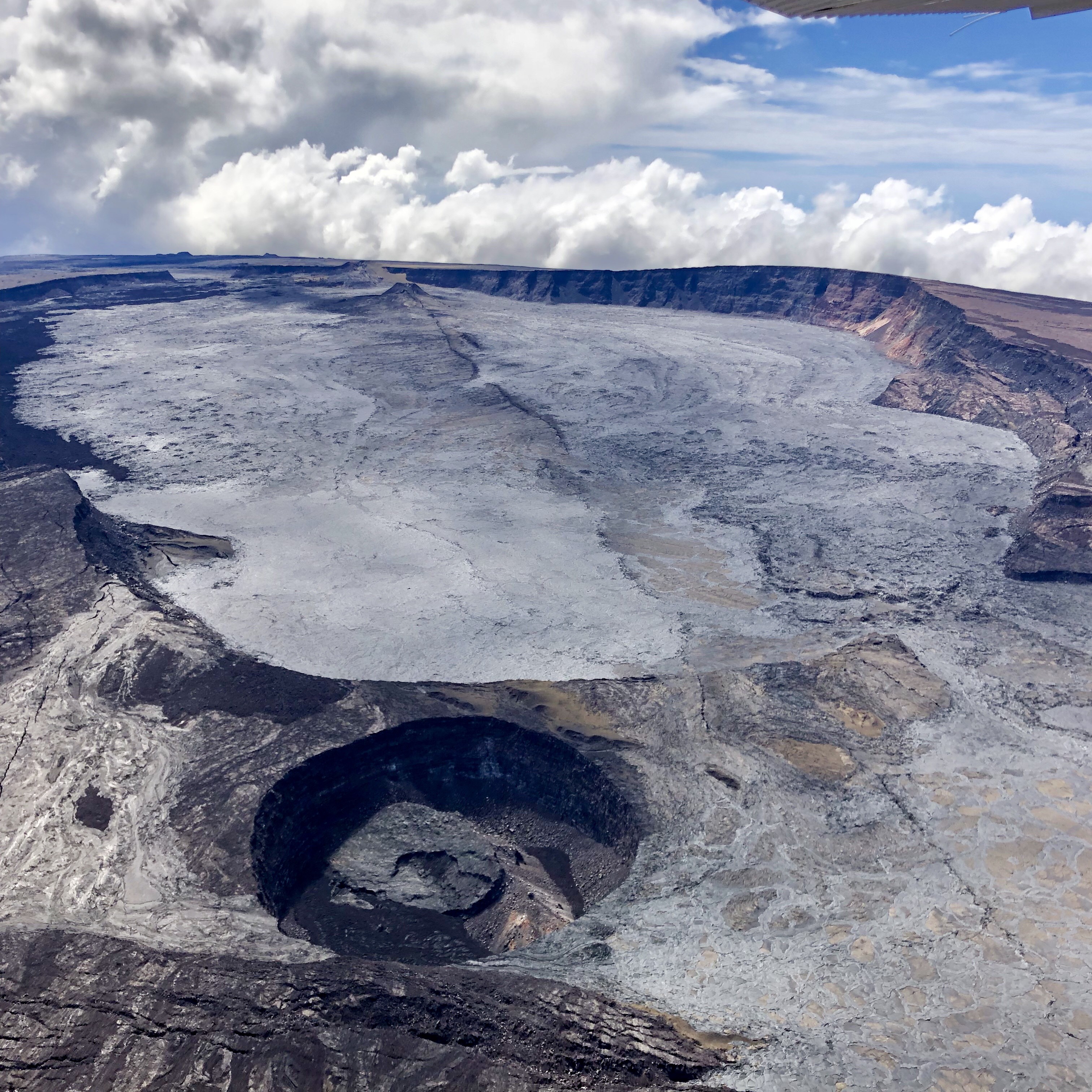
Global Positioning System (GPS) measurements show low rates of deformation in the volcano’s summit region continuing through the past week.
Concentrations of sulfur dioxide (SO2), hydrogen sulfide (H2S), and carbon dioxide (CO2), as well as fumarole temperatures, remain stable at both the summit and at Sulphur Cone on the upper Southwest Rift Zone.
Webcam views have shown no changes to the volcanic landscape on Mauna Loa over the past week.
Source et photo : HVO
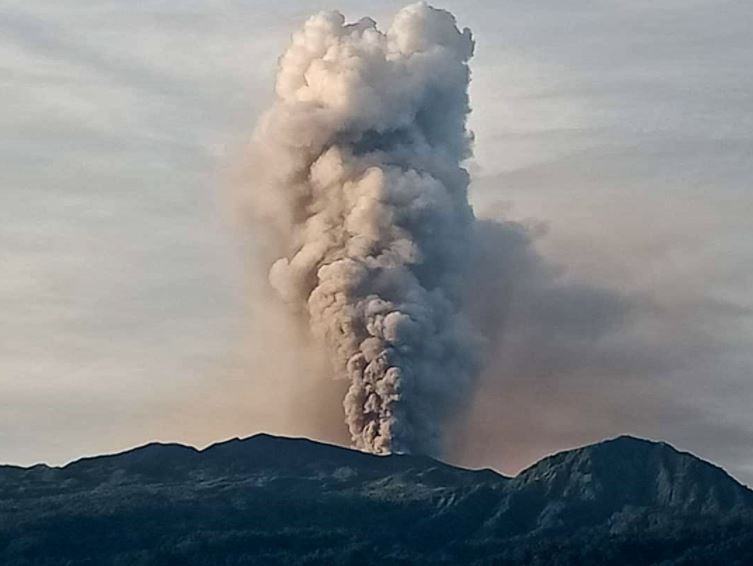
Ecuador , Reventador :
DAILY REPORT OF THE STATE OF THE REVENTADOR VOLCANO, Saturday August 27, 2022.
Information Geophysical Institute – EPN.
Surface Activity Level: Moderate, Surface Trend: No change.
Internal activity level: Moderate, Internal trend: No change.
Seismicity: From August 26, 2022, 11:00 a.m. to August 27, 2022, 11:00 a.m.:
Explosion (EXP): 34
Long Periods (LP): 49
Emission Tremors (TREMI): 4
Harmonic Tremor (TRARM): 8
Rains / Lahars:
No rain was recorded in the area.
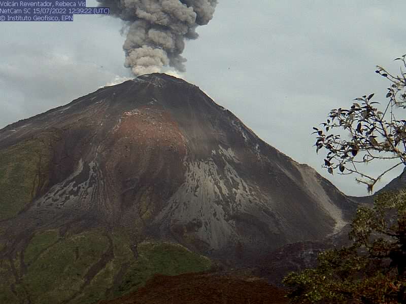
Emission / ash column:
Several ash emissions were observed, with heights of up to 1000 meters above crater level with directions to the west and northwest. The Washington VAAC reported several alerts of ash emission observed on satellite, heading west, with a height of 988 meters above the level of the crater.
Other monitoring parameters.
The MIROVA system recorded 1 weak thermal anomaly and 1 moderate thermal anomaly in the last 24 hours. The FIRMS system recorded 14 thermal anomalies over the past 24 hours.
Observation:
During the night and the early hours of the morning, an incandescence could be observed at the level of the crater. At the moment the volcano area is cloudy
Alert level: Orange.
Source : IGEPN
Photo : IGEPN (Archives).