February 01 , 2024.
Hawaii , Kilauea :
HVO/USGS Volcanic Activity Notice
Current Volcano Alert Level: WATCH
Previous Volcano Alert Level: ADVISORY
Current Aviation Color Code: ORANGE
Previous Aviation Color Code: YELLOW
Issued: Wednesday, January 31, 2024, 4:41 AM HST
Source: Hawaiian Volcano Observatory
Notice Number: 2023/H333
Location: N 19 deg 25 min W 155 deg 17 min
Elevation: 4091 ft (1247 m)
Area: Hawaii
Volcanic Activity Summary:
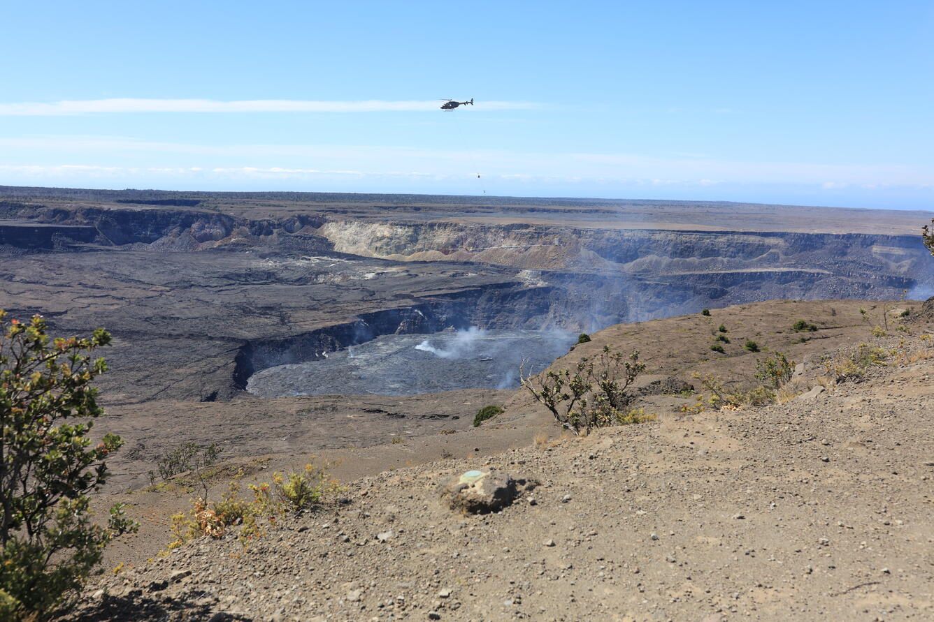
Kīlauea volcano is not erupting. Increased earthquake activity and inflationary ground deformation at Kīlauea’s summit began occurring during the early morning hours of January 31, 2024, indicating movement of magma in the subsurface.
The USGS Hawaiian Volcano Observatory is raising the volcano alert level/aviation color code for Kīlauea from ADVISORY/YELLOW to WATCH/ORANGE due to this activity.
At this time, it is not possible to say with certainty if this activity will lead to an eruption; the activity may remain below ground. However, an eruption in Kīlauea’s summit region, within Hawai‘i Volcanoes National Park and away from infrastructure, is one potential outcome. Patterns of earthquake activity and ground deformation are concentrated south of the caldera region. Any new eruptive activity could occur in or near Halemaʻumaʻu crater or the region south of Kīlauea caldera, within the closed area of Hawaiʻi Volcanoes National Park.
HVO is in constant communication with Hawai‘i Volcanoes National Park as this situation evolves. The activity is confined entirely within the park.
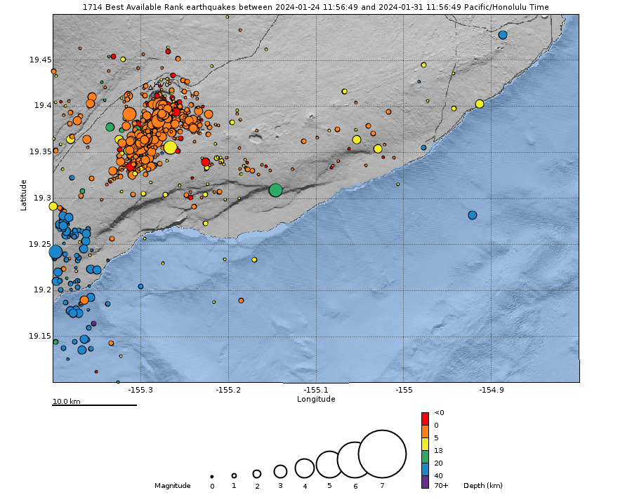
Wednesday, January 31, 2024, 5:55 PM HST (Thursday, February 1, 2024, 03:55 UTC)
Activity beneath Kīlauea’s summit remains heightened and dynamic. The increase in seismicity and deformation that began in the south caldera region early this morning has fluctuated in intensity throughout the day but remains high overall. Kīlauea’s summit is pressurized; an eruption could occur with little warning. Increased seismicity and deformation remain restricted to the summit region and no unusual activity has been noted in the East Rift Zone or Southwest Rift Zone.
Since 3:00 a.m. HST, the number of detected earthquakes per hour has varied between 25-40. These events have occurred at depths of 1.5–3 km (1–2 mi) below the surface in clusters that have migrated between the area just south of Halema’uma’u and the region southwest of the outer caldera boundary. In total, there have been over 500 located earthquakes in this region since midnight, with magnitudes ranging from a maximum of 3.4 to less than 1, and more than 1,400 earthquakes since 9 a.m. HST on Saturday January 27th. Several of these earthquakes were large enough to be felt by neighboring communities, though none have been large enough to cause damage. The stronger earthquakes also continue to trigger rockfalls within Halemaʻumaʻu.
Tiltmeters at Sand Hill and Uēkahuna bluff have continued to show highly variable directions and rates of tilt throughout the day, typical of ground deformation coupled with shallow crack growth that can precede either an eruption or shallow intrusion. Approximately 20 microradians of change have been recorded since 4:00 a.m. HST. Step-wise changes in the tilt signals are attributed to the instruments being shaken by nearby earthquakes or rockfalls.
Patterns of ground deformation and earthquakes since this morning indicate that pulses of magma continue to move beneath the surface of the region south of Halemaʻumaʻu to the area southwest of Kīlauea’s caldera. At the time of this report, activity remains elevated; periods of increased earthquake activity and rates of ground deformation can be expected to continue.
Current monitoring data show no indication that an eruption associated with this activity could occur far from Halemaʻumaʻu or the nearby area just to the south. Current wind conditions are weak and out of the south, so strong degassing could impact areas of Hawaiʻi Volcanoes National Park and surrounding communities if an eruption does occur in the summit region.
Source : HVO
Photos : USGS , USGS / K. Mulliken( archive)
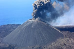
Ethiopia , Ertaale :
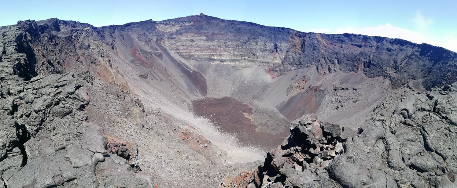
During 13-23 January lava flows emerged from vents in Erta Ale’s S pit crater and traveled about 500 m S, 200 m NW, and 250 m SSW based on satellite images. Visitors to the volcano took photographs and video of low lava fountaining at a cone and advancing pahoehoe flows. Activity increased notably during the morning of 27 January.

The Erta Ale basaltic shield volcano in Ethiopia has a 50-km-wide edifice that rises more than 600 m from below sea level in the Danakil depression. The volcano includes a 0.7 x 1.6 km summit crater hosting steep-sided pit craters. Another larger 1.8 x 3.1 km wide depression elongated parallel to the trend of the Erta Ale range is located SE of the summit and is bounded by curvilinear fault scarps on the SE side. Basaltic lava flows from these fissures have poured into the caldera and locally overflowed its rim. The summit caldera usually also holds at least one long-term lava lake that has been active since at least 1967, and possibly since 1906. Recent fissure eruptions have occurred on the N flank.
Source : GVP
Photo : Aventure et volcans ( amitiés à mon ami Guy).
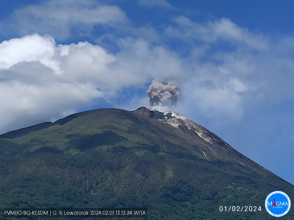
Indonesia , Ili Lewotolok :
An eruption of Mount Ili Lewotolok occurred on Thursday, February 1, 2024 at 1:09 p.m. WITA with the height of the ash column observed at ±500 m above the summit (±1923 m above sea level). The ash column was gray in color with moderate to thick intensity, oriented towards the Northeast. This eruption was recorded on a seismograph with a maximum amplitude of 32 mm and a duration of 115 seconds.
SEISMICITY OBSERVATIONS.
75 eruption/explosion earthquakes with an amplitude of 28 to 37.6 mm and a duration of 39 to 128 seconds.
141 emission earthquakes with an amplitude of 2.3 to 25.7 mm and earthquake duration of 25 to 112 seconds.
2 harmonic tremors with an amplitude of 4 to 5.8 mm and an earthquake duration of 201 to 239 seconds.
6 non-harmonic tremors with an amplitude of 3.3 to 9.3 mm and an earthquake duration of 121 to 257 seconds.
1 local tectonic earthquake with an amplitude of 1.4 mm, and duration of the earthquake of 18 seconds.
1 Distant tectonic earthquake with an amplitude of 1.9 mm, and the earthquake lasted 80 seconds.
RECOMMENDATION
At activity level Level II (WASPADA), it is recommended:
(1) Communities around Mount Ili Lewotolok as well as visitors/climbers/tourists should not enter or conduct activities within a 2 km radius around the Mount Ili Lewotolok activity center, and residents of Lamawolo villages , Lamatokan and the village of Jontona should always be alert to the potential threat of danger from lava avalanches and hot clouds originating from the eastern part of the summit/crater of Mt. Ili Lewotolok.
PVMBG reported that the eruption at Lewotolok continued during 24-30 January. White gas-and-steam plumes rose 50-100 m above the summit and drifted NE, E, and SE on 27 and 29 January. White-and-gray plumes rose 50-200 m above the summit and drifted SE on 28 January. Emissions were not visible on the other days. The Alert Level remained at 2 (on a scale of 1-4) and the public was warned to stay at least 2 km away from the summit crater.
Sources : Magma Indonésie , GVP.
Photo : PVMBG
Colombia , Nevado del Ruiz :
Weekly bulletin on the activity of the Nevado del Ruiz volcano
From the monitoring of the activity of the NEVADO DEL RUIZ VOLCANO, the MINISTRY OF MINES AND ENERGY through the COLOMBIAN GEOLOGICAL SERVICE (SGC) reports that:
In the week of January 23-29, 2024, the volcano continued with unstable behavior characterized by low levels of activity. Compared to the previous week, the main variations in the parameters monitored were:
– Seismic activity associated with the fracturing of rocks within the volcanic edifice has increased in the number of earthquakes recorded and has maintained similar levels in seismic energy released. The earthquakes were located mainly in the Arenas crater and on the northeast and south-southeast flanks of the volcano, at distances less than 6 km from the crater. The depths of the events varied between less than 1 and 7 km from the volcano summit. The highest magnitude of the week was 1.3, corresponding to the earthquake of January 24 at 9:05 p.m., located approximately 1 km south-southeast of the crater, 3 km deep. Seismicity related to the activity of the lava dome (protrusion or mound) located at the bottom of the crater increased in duration and number of events, however, it maintained low energy levels.

– Seismicity related to pulsatile emissions of ash and gas into the atmosphere has maintained similar levels in the number of recorded earthquakes and decreased in the seismic energy released. In general, seismic signals had low energy levels. Some of these seismic signals were associated with ash emissions or changes in the relative temperature of the emitted material. Both phenomena were confirmed thanks to the cameras used to monitor the volcano.
– Sulfur dioxide (SO2) outgassing rates were variable and maintained a downward trend. On several occasions, particularly in the early morning, the column of gas without water vapor and without shades of blue due to the presence of aerosols was observed. The maximum height of the gas or ash column was 1,000 m vertical and 1,800 m dispersed.
These values were measured at the summit of the volcano on January 25 and 29, 2024. The direction of dispersion of the column predominated towards the north and northwest flanks of the volcano.
– In monitoring thermal anomalies at the bottom of Arenas Crater, from satellite monitoring platforms, a high number of detections is maintained given the good meteorological conditions in the area and anomalies of moderate energy levels persist.
Source et photo : SGC
La Réunion , Piton de la Fournaise :
Seismicity
In January 2024, the OVPF-IPGP recorded in total at the Piton de la Fournaise massif:
• 4 superficial volcano-tectonic earthquakes (0 to 2.5 km above sea level) under the summit craters;
• 2 deep earthquakes (below sea level);
• 0 long-period earthquakes;
• 358 landslides.
The month of January 2024 was marked by low seismicity under the Piton de la Fournaise with only 4 superficial volcano-tectonic earthquakes and two deep earthquakes recorded.
Only two superficial volcano-tectonic earthquakes could be located, under the eastern part of the Dolomieu crater. The others – of lower magnitudes – could not be located.
Numerous (358) landslides in the Dolomieu Crater, at the Cassé de la Rivière de l’Est and at the level of recent lava flows were also recorded, particularly following the heavy rains which affected the volcano area in the last half of January .
Deformation
In November 2023, a resumption of peak inflation was recorded. This stopped at the end of November and was followed by a period of peak deflation until the end of 2023.
During the month of January 2024, no significant deformation was recorded.
Balance sheet
Since December 2023, magma replenishment and pressurization of the surface reservoir have ceased.
In January 2024, seismicity remained low with only 4 volcano-tectonic earthquakes recorded under the summit craters.
Note that since 2016, the replenishment of the superficial magmatic reservoir under the Piton de la Fournaise has taken place in pulses, thus such phases of calm in deformations and seismicity have already been observed on several occasions between 2016 and 2023 over periods ranging from approximately 15 to 80 days.
Source et photo : OVPF