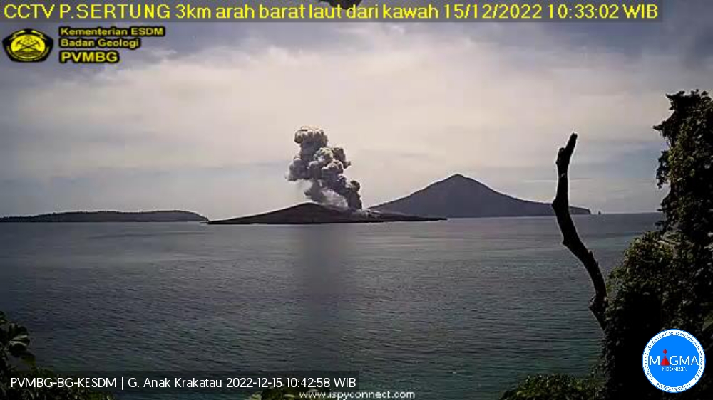
December 15 , 2022.
Indonesia , Anak Krakatau :
An eruption of Mount Anak Krakatau occurred on Thursday, December 15, 2022 at 10:31 a.m. WIB. The height of the eruptive column was observed at ± 700 m above the summit (± 857 m above sea level). The ash column was observed to be gray with thick intensity, oriented northeast. The eruption was recorded on a seismograph with a maximum amplitude of 37 mm and a duration of 286 seconds.
VOLCANO OBSERVATORY NOTICE FOR AVIATION – VONA
Issued : December 15 , 2022
Volcano : Anak Krakatau (262000)
Current Aviation Colour Code : ORANGE
Previous Aviation Colour Code : orange
Source : Anak Krakatau Volcano Observatory
Notice Number : 2022KRA585
Volcano Location : S 06 deg 06 min 07 sec E 105 deg 25 min 23 sec
Area : Lampung, Indonesia
Summit Elevation : 502 FT (157 M)
Volcanic Activity Summary :
Eruption with volcanic ash cloud at 03h31 UTC (10h31 local).
Volcanic Cloud Height :
Best estimate of ash-cloud top is around 2742 FT (857 M) above sea level or 2240 FT (700 M) above summit. May be higher than what can be observed clearly. Source of height data: ground observer.
Other Volcanic Cloud Information :
Ash cloud moving to northeast. Volcanic ash is observed to be gray. The intensity of volcanic ash is observed to be thick.
Remarks :
Tremor recorded on seismogram with maximum amplitude 5 mm. Eruption recorded on seismogram with maximum amplitude 37 mm and maximum duration 276 second.
Source et photo : Magma Indonésie.
Chile , Copahue :
Seismology
The seismological activity of the period was characterized by the recording of:
31 VT-type seismic events, associated with rock fracturing (Volcano-Tectonics). The most energetic earthquake presented a value of local magnitude (ML) equal to 1.5, located 4.8 km east-northeast of the volcanic edifice, with a depth of 4.2 km from the active crater.
6 LP-type seismic events, associated with fluid dynamics within the volcanic system (Long Period). The size of the largest earthquake assessed from the Reduced Displacement (DR) parameter was equal to 4 cm2.
2 VLP-type seismic events, associated with the dynamics of large volumes of fluids within the volcanic system (Very Long Period). The size of the largest earthquake assessed from the Reduced Displacement (DR) parameter was equal to 4 cm2.
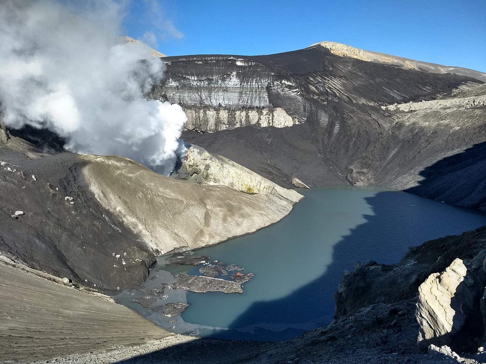
Fluid Geochemistry
Data on sulfur dioxide (SO2) emissions obtained by optical differential absorption spectroscopy (DOAS) equipment, corresponding to the Mellizas station, installed 6 km east-northeast (ENE) of the crater active, presented an average value of 541 ± 108 t/d, with a maximum value of 2439 t/d on 15 November. According to the activity of the volcano, these values remain at levels considered low.
Four satellite anomalies were reported in sulfur dioxide (SO2) emissions in the atmosphere of the area near the volcanic edifice, on November 15, 16, 17 and 21, according to data published by the Tropospheric Monitoring Instrument (TROPOMI ) and the Ozone Monitoring Instrument (IMO).
Satellite thermal anomalies
During the period, 4 thermal alerts were recorded in the area associated with the volcano, with a maximum Volcanic Radiative Power (VRP) of 8 MW on November 18, a value considered low according to data processed by the Middle Infrared of Observation of Volcanic Activity. (MIROVA). Through analysis of Sentinel 2L2A satellite images, 3 radiance anomalies were detected in the area associated with the crater, on November 16, 19 and 21, with a maximum anomalous radiance zone of 4750 m2 on November 16.
Surveillance cameras
The images provided by the fixed camera, installed near the volcano, recorded an increase in degassing from November 15, white and gray, with a maximum column height of 1740 meters, on November 21 and 22. Days 15 and 16 stand out where gray outgassing was identified due to ash content.
An incandescence was also recorded between November 15-20 and 29 with a maximum height of 400 m on the 17th.
Satellite geomorphological analysis
Based on Planet Scope and Sentinel 2-L2A satellite imagery, evidence of ash deposition in the SE direction of the active crater with a maximum range of 4 km identified for 19 November.
Activity remained at levels considered low, suggesting stability of the volcanic system. The volcanic technical alert is maintained at:
GREEN TECHNICAL ALERT: Active volcano with stable behavior – There is no immediate risk
Source : Sernageomin.
Photos : Carpediem1971, OAVV. (archives).
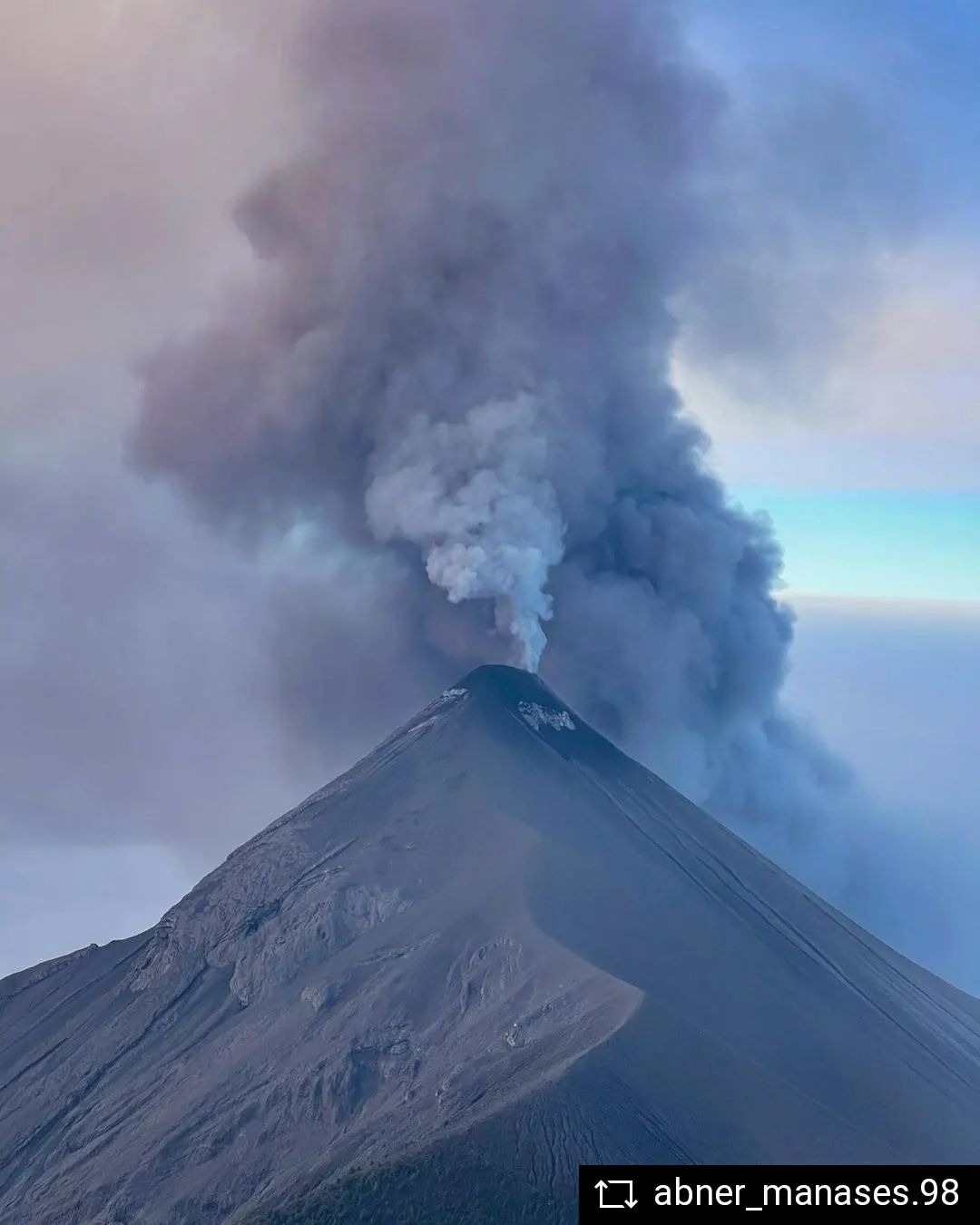
Guatemala , Fuego :
Activity :
The Fuego volcano observatory reports a weak white degassing and 4 to 10 explosions per hour, of weak, moderate and strong characteristics, which raise columns of gray ash to heights of 4,500 to 5,000 meters above the level of the sea (14,764 to 16,404 feet). These disperse to the West, North-West and South-West over distances of 10 to 15 kilometers, producing ash falls on Panimaché I, Panimaché II, Morelia, Santa Sofía, El Porvenir, Palo Verde, Sangre de Cristo and Yepocapa. The wind is remobilizing ash from the recent eruption and keeping it suspended over the area. The explosions produce pulses of incandescent material up to 200 meters above the crater, covering the upper part of the cone and producing weak, moderate and strong avalanches towards the ravines of Seca, Taniluyá, Ceniza, Trinidad and Las Lajas, some descending towards the edge of the vegetation, as well as low to moderate rumblings with shock waves that vibrate the roofs and windows of the houses of the communities near the volcano.
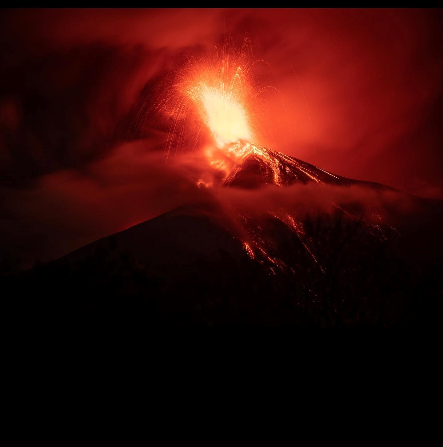
INSIVUMEH reported that the eruption at Fuego was ongoing during 7-13 December, though activity had notably intensified during 10-11 December. The seismic network recorded 4-10 explosions per hour during the week, with ash plumes rising as high as 1.2 km above the crater rim. The ash plumes generally drifted 10-20 km NW, W, and SW, causing daily ashfall in areas downwind including Morelia (9 km SW), Panimaché I and II (8 km SW), Santa Sofía (12 km SW), El Porvenir (8 km ENE), Finca Palo Verde, Sangre de Cristo (8 km WSW), San Pedro Yepocapa (8 km NW). Daily shock waves rattled structures in communities around the volcano. Daily block avalanches descended the Ceniza (SSW), Seca (W), Trinidad (S), Taniluyá (SW), Honda, Las Lajas (SE), and El Jute (ESE) drainages, often reaching vegetated areas. Strombolian explosions ejected incandescent material as high as 200 m above the summit on a few of the days.
Activity increased on 10 December. In a special report posted at 2241, INSIVUMEH noted that in the previous minutes multiple explosions of variable intensities produced ash plume that rose 1.2 km above the summit and drifted 30 km W and NW. Pulsating lava fountains rose as high as 500 m above the summit. A lava flow had traveled 800 m down the Ceniza drainage by the time the report was issued, and avalanches of material spalled from its front reached vegetated areas. At 2300 pyroclastic flows descended the Las Lajas drainage several kilometers. Dense ash plumes and pyroclastic flows down the Las Lajas drainage continued for at least an hour. Just before 0030 on 11 December pyroclastic flows traveled several kilometers down the Ceniza drainage on the SW flank. Lava fountains rose as high as 300 m. By 0640 dense ash plumes were rising over 1.2 km above the summit and the lava flow remained active. Avalanches of material from the advancing lava front descended to vegetated areas. Satellite images showed that ash clouds had spread NE, E, and SE, covering a wide area in the department of Sacatepéquez and the central and southern parts of the department of Guatemala. Activity decreased by the early afternoon; lava fountaining, dense ash emissions, and pyroclastic flows had all ceased before 14h10.
Sources : Insivumeh , GVP.
Photos : Diego Rizzo , Abner Manasés Marcos @abner_manases.98.
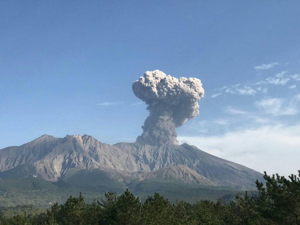
Japan , Sakurajima :
The JMA reported ongoing eruptive activity in the Minamidake crater (on Sakurajima volcano) from December 5-12 consisting of a few eruptive events and three explosions. The incandescence of the crater was visible at night. The explosions produced ash plumes that rose up to 2.7 km above the crater rim and ejected large boulders up to 1.1 km away. Sulfur dioxide emissions were high at 2,800 tonnes per day on December 6. The Alert Level remained at 3 (on a 5-level scale) and residents were warned to stay 2 km from the crater.
La caldeira d’Aira dans la moitié Nord de la baie de Kagoshima contient le volcan post-caldeira Sakurajima, l’un des plus actifs du Japon. L’éruption de la volumineuse coulée pyroclastique d’Ito a accompagné la formation de la caldeira de 17 x 23 km il y a environ 22 000 ans. La plus petite caldeira de Wakamiko s’est formée au début de l’Holocène dans le coin Nord-Est de la caldeira d’Aira, ainsi que plusieurs cônes post-caldeira. La construction du Sakurajima a commencé il y a environ 13 000 ans sur le bord Sud de la caldeira d’Aira et a construit une île qui a finalement été reliée à la péninsule d’Osumi lors de la grande éruption explosive et effusive de 1914. L’activité du cône du sommet de Kitadake s’est terminée il y a environ 4850 ans, après quoi des éruptions ont eu lieu depuis le Minamidake. De fréquentes éruptions historiques, enregistrées depuis le VIIIe siècle, ont déposé des cendres sur Kagoshima, l’une des plus grandes villes de Kyushu, située de l’autre côté de la baie de Kagoshima à seulement 8 km du sommet. La plus grande éruption historique a eu lieu entre 1471 et 1476.
Sources : Agence météorologique japonaise (JMA), GVP.
Photo : Rizal M.
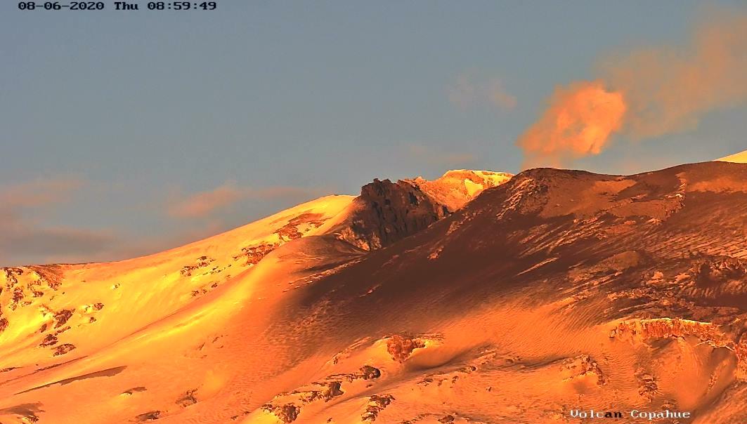
Ecuador , Cotopaxi :
WEDNESDAY DECEMBER 14, 2022
Until now, the seismic stations of the Cotopaxi volcano recorded a tremor signal, probably linked to gas and ash emission activity. This activity started from 15:00 TL. The signal amplitude was maintained at 200 RSAM points and is weak compared to the most active pulses of the volcano’s current eruptive period. Therefore, there is a low probability of ash fall in areas surrounding the volcano. Thanks to the network of surveillance cameras, the volcano remained cloudy, preventing direct observation of activity at the surface level. The IG-EPN continues to monitor the event and will inform in a timely manner if any changes in the seismic signals are detected.
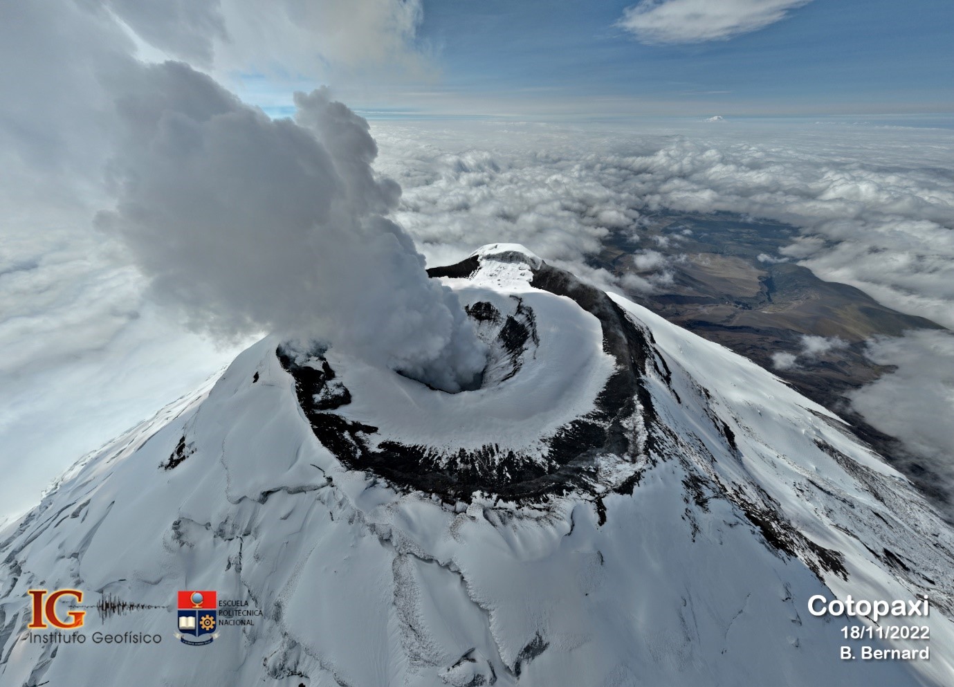
IG reported that the low-level eruption at Cotopaxi continued during 7-13 December characterized by steam-and-gas emissions and occasional ash emissions. Sulfur dioxide emissions measured by satellite almost daily averaged 665-2,745 tons per day. Steam-and-gas emissions observed during 7-10 December rose as high as 2 km above the crater rim and drifted SW, W, and NW. Ash emissions during 0758-0816 on 8 December rose 1 km and drifted WNW. The Washington VAAC issued three advisories noting that ash rose 800-1,100 m and drifted W. A tremor signal that started at 0832 on 9 December was probably related to gas-and-ash emissions, though cloudy weather conditions prevented visual confirmation. During the night of 9-10 December several steam-and-ash emissions were identified in satellite images rising as high as 1.1 km and drifting NW. Minor ashfall was reported in Conocoto-Pichincha in the morning of 10 December. At 0930 on 11 December the seismic stations recorded a signal related to gas-and-ash emissions that rose 2 km and drifted W. Ash fell in Control Caspi, located at the S entrance to Parque Nacional Cotopaxi. Several gas-and-steam emissions with low ash content were visible that afternoon and during the morning of 12 December rising as high as 500 m and drifting W. Servicio Nacional de Gestión de Riesgos y Emergencias (SNGRE) maintained the Alert Level at Yellow (the second lowest level on a four-color scale).
Source : IGEPN, GVP.
Photo : igepn / Benjamin Bernard