August 23 , 2022 .
Philippines , Bulusan :
August 21 , 2022 , 06:00 PM
Notice for the lowering of the alert status of Bulusan Volcano from Alert Level 1 (Low-Level of Unrest) to Alert Level 0 (Normal).
Bulusan Volcano has returned to normalcy following a general decline in monitoring parameters. This is supported by the following observations:
-Volcanic Earthquake Activity: The frequency of volcanic earthquakes has declined to baseline levels (0-5 earthquakes/day) since the third week of July 2022. This indicates that rock-fracturing within the volcanic edifice associated with shallow hydrothermal activity has diminished.
-Ground Deformation: Data from continuous GPS measurements and radial tilt indicated short-term inflation of the southeastern edifice of Bulusan Volcano since April 2022. However, long-term ground deformation suggests that this is primarily driven by tectonic processes rather than pressurization from subsurface magma.
-Gas Emission: Sulfur Dioxide emission or SO2 flux from Bulusan based on gas spectrometry has declined from an average of approximately 1,900 tonnes/day between 5 and 12 June 2022 to 230 tonnes/day between 25 July and 6 August 2022. The diminishing concentration of SO2 likely indicates the depletion of volcanic gas input to the active shallow hydrothermal system.
-Visual Observation of the Summit: Degassing activity from the active vents has diminished to very weak to moderate emission of steam-laden plumes.
In view of the above, PHIVOLCS-DOST is now lowering the alert status of Bulusan from Alert Level 1 to Alert Level 0. This means observational parameters have returned to baseline or background levels and no magmatic eruption is foreseen in the immediate future. However, in the event of a renewed increase in any one or combination of the above monitoring parameters, the alert status may step up once again to Alert Level 1. The local government units and the public, however, are reminded that entry into the 4-kilometer radius Permanent Danger Zone (PDZ) particularly near the vents on the south-southeastern slopes, should be avoided due to the possibility of sudden and hazardous steam-driven or phreatic eruption, rockfall and landslide. Civil aviation authorities must also advise pilots to avoid flying close to the volcano’s summit as ash from any sudden phreatic eruption can be hazardous to aircraft. Furthermore, people living within valleys and along river/stream channels should be vigilant against sediment-laden stream flows and lahars in the event of heavy and prolonged rainfall.
DOST-PHIVOLCS is closely monitoring Bulusan Volcano’s condition and any new development will be relayed to all concerned.
Source et photo : Phivolcs.
Peru , Sabancaya :
Analysis period: from August 15, 2022 to August 21, 2022, Arequipa, August 22, 2022.
Alert level: ORANGE
The Geophysical Institute of Peru (IGP) reports that the eruptive activity of the Sabancaya volcano remains at moderate levels, that is to say with the recording of an average of 33 daily explosions, with columns of ash and of gas up to 2.6 km altitude above the summit of the volcano and their subsequent dispersion. Therefore, for the following days, no significant change is expected in eruptive activity.
The IGP recorded and analyzed the occurrence of 427 earthquakes of volcanic origin, associated with the circulation of magmatic fluids inside the Sabancaya volcano. An average of 33 explosions was recorded daily, in addition to recording Volcano-Tectonic (VT) type events associated with rock fracturing inside the Sabancaya volcano.

Monitoring the deformation of the volcanic structure using GNSS techniques (processed with fast orbits) does not show any significant anomalies. However, in general, an inflation process has been observed in the northern sector (surroundings of the Hualca Hualca volcano). Visual surveillance identified columns of gas and ash up to 2.6 km above the summit of the volcano, which were dispersed towards the northern and eastern sectors of Sabancaya. Satellite recordings have identified the presence of 9 thermal anomalies, with a maximum value of 23 MW, associated with the presence of a lava body on the surface of the volcano’s crater.
RECOMMENDATIONS
• Keep the volcanic alert level orange.
• Do not approach within a radius of less than 12 km from the crater.
Source : Cenvul
Photo : Zintia Roxana Fernández Licla.
Russia / Kuril Islands , Chikurachki :
VOLCANO OBSERVATORY NOTICE FOR AVIATION (VONA)
Issued: August 23 , 2022
Volcano: Chikurachki (CAVW #290360)
Current aviation colour code: ORANGE
Previous aviation colour code: green
Source: KVERT
Notice Number: 2022-92
Volcano Location: N 50 deg 19 min E 155 deg 27 min
Area: Northern Kuriles, Russia
Summit Elevation: 1816 m (5956.48 ft)
Volcanic Activity Summary:
According to the data by observers, an ash emission was observing from Chikurachki volcano on 22 August, 2022. The explosions sent ash up to 2 km a.s.l., an ash plume was moving to the east of the volcano. KVERT continues to monitor Chikurachki volcano.
 .
.
This eruptive activity of the volcano is observing. Ash explosions up to 6 km (19,700 ft) a.s.l. could occur at any time. Ongoing activity could affect low-flying aircraft.
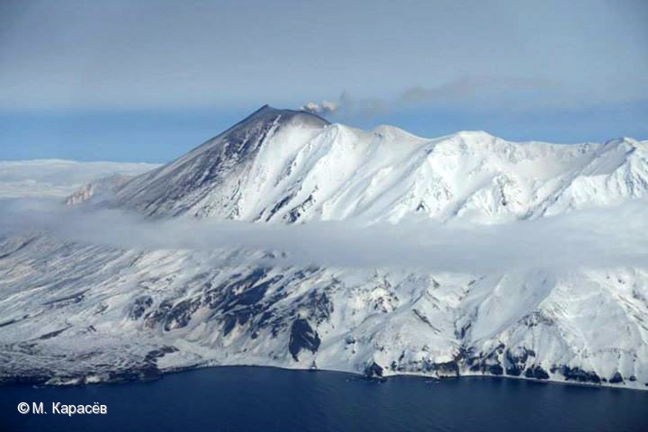
Chikurachki, the highest volcano on Paramushir Island in the northern Kuriles, is a relatively small cone constructed on a high Pleistocene edifice. Oxidized basaltic-to-andesitic scoria deposits covering the upper part of the young cone give it a distinctive red color. Frequent basaltic Plinian eruptions have occurred during the Holocene. Lava flows have reached the sea and formed capes on the NW coast; several young lava flows are also present on the E flank beneath a scoria deposit. The Tatarinov group of six volcanic centers is located immediately to the south, and the Lomonosov cinder cone group, the source of an early Holocene lava flow that reached the saddle between it and Fuss Peak to the west, lies at the southern end of the N-S-trending Chikurachki-Tatarinov complex. In contrast to the frequently active Chikurachki, the Tatarinov centers are extensively modified by erosion and have a more complex structure. Tephrochronology gives evidence of an eruption around 1690 CE from Tatarinov, although its southern cone contains a sulfur-encrusted crater with fumaroles that were active along the margin of a crater lake until 1959.
Source : Kvert , GVP.
Photo : M. Karasev ( 2015) .
Hawaii , Kilauea :
19°25’16 » N 155°17’13 » W,
Summit Elevation 4091 ft (1247 m)
Current Volcano Alert Level: WATCH
Current Aviation Color Code: ORANGE
Activity Summary:
The summit eruption of Kīlauea Volcano, within Halemaʻumaʻu crater, continued over the past 24 hours. All recent eruptive activity has been confined to the crater. No significant changes have been observed at the summit or in either rift zone.
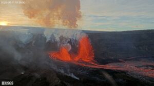
Halemaʻumaʻu Lava Lake Observations:
Eruption of lava from the western vent into the active lava lake and onto the crater floor continued over the past 24 hours. The active part of the lava lake showed continuous surface activity. Surface activity, outside the lava lake, occasionally occurs from breakouts along the margins of the crater. Overflight measurements from August 16, 2022, indicated that the crater floor had seen a total rise of about 137 meters (449 feet).
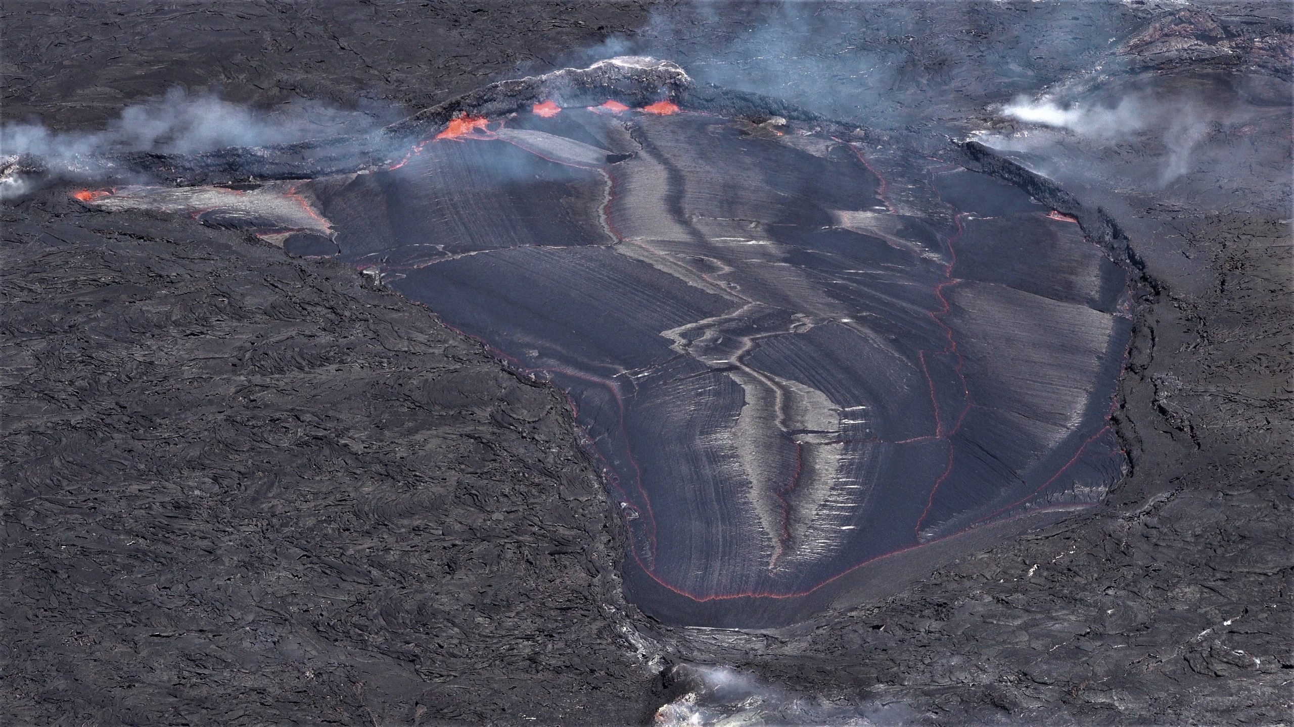
Image of the lava lake in Halema‘uma‘u, at the summit of Kīlauea. Lava enters the lake at the west end (bottom of image) and flow steadily towards the east end, where the crust is consumed along the lake margins. USGS photo by M. Patrick.
Summit Observations:
Summit tiltmeters recorded no change in tilt over the past day. Volcanic tremor remains above background levels. A sulfur dioxide (SO2) emission rate of approximately 1,250 tonnes per day (t/d) was measured on August 19, 2022.
Rift Zone Observations:
No unusual activity has been noted along the East Rift Zone or Southwest Rift Zone; low rates of ground deformation and seismicity continue along both. Measurements from continuous gas monitoring stations downwind of Puʻuʻōʻō in the middle East Rift Zone remain below detection limits for SO2, indicating that SO2 emissions from Puʻuʻōʻō are negligible.
Source : HVO.
Photo : USGS / M. Patrick.
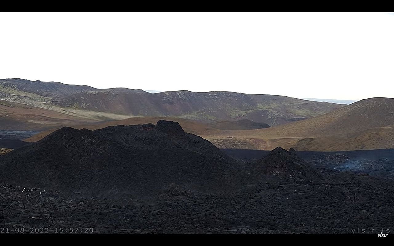
Iceland , Meradalur :
Last night flowing lava was visible at the eruption site at Meradalir, even though no harmonic tremors have been detected from the crater since yesterday morning. This is not unheard of, according to a specialist at the Met Office, who says that this might be lava that is still cooling, but originating from a time before the activity went down. No harmonic tremors are detected now, but so far in both this eruption and the one from last year the tremors have been a strong signifier of the volcano being active.
Lovísa Mjöll Guðmundsdóttir, a natural disaster specialist with the Met Office says it is normal to see flowing lava so soon after activity has dropped in the volcano. She says that everything points to the eruption being at a standstill and no harmonic murmurs have been detected. Last year when the eruption was in Fagradalsfjall, the same thing happened, when the activity dropped for a few days and the volcano was dormant like it is now.
No meetings have been scheduled today about the eruption, but she points out that the meetings are often set with short notice when something happens.
The scientists at the Met Office are not ready to call the eruption in Meradalir off, because there needs to be no activity for at least a few days or even weeks before that announcement, because there have been instances where eruptions die down for a few days and then start again.
Source : icelandmonitor.mbl.is
Photo : Visir is