August 20 , 2022 .
Hawaii , Kilauea :
19°25’16 » N 155°17’13 » W,
Summit Elevation 4091 ft (1247 m)
Current Volcano Alert Level: WATCH
Current Aviation Color Code: ORANGE
Activity Summary:
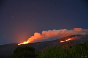
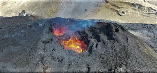
The summit eruption of Kīlauea Volcano, within Halemaʻumaʻu crater, continued over the past 24 hours. All recent activity has been confined to the crater. No significant changes have been observed at the summit or in either rift zone.
Halemaʻumaʻu Lava Lake Observations:
Eruption of lava from the western vent into the active lava lake and onto the crater floor continued over the past 24 hours. The active part of the lava lake showed continuous surface activity. Surface activity, outside the lava lake, occasionally occurs from breakouts along the margins of the crater. Since the beginning of this eruption on September 29, 2021, the crater floor has seen a total rise of about 136 meters (446 feet).
Summit Observations:
Summit tiltmeters began recording inflationary tilt around 3:00 p.m. yesterday afternoon in response to the lastest deflation-inflation event. Volcanic tremor remains above background levels. A sulfur dioxide (SO2) emission rate of approximately 1,150 tonnes per day (t/d) was measured on August 12, 2022.
Rift Zone Observations:
No unusual activity has been noted along the East Rift Zone or Southwest Rift Zone; low rates of ground deformation and seismicity continue along both. Measurements from continuous gas monitoring stations downwind of Puʻuʻōʻō in the middle East Rift Zone remain below detection limits for SO2, indicating that SO2 emissions from Puʻuʻōʻō are negligible.
Source : HVO.
Photo : UGSS / K. Mulliken.
Samoa Islands , Ta’u :
Current Volcano Alert Level: ADVISORY
Current Aviation Color Code: YELLOW
Issued: Friday, August 19, 2022, 2:01 PM HST
Source: Hawaiian Volcano Observatory
Notice Number: 2022/H370
Location: S 14 deg 10 min W 169 deg 37 min
Elevation: 2096 ft (639 m)
Area: American Samoa
Volcanic Activity Summary:
An earthquake swarm is occurring in the Manuʻa Islands of American Samoa. As the federal entity responsible for monitoring earthquakes and volcanoes in American Samoa, the U.S. Geological Survey Hawaiian Volcano Observatory (HVO) is assigning the Taʻū Island and Ofu-Olosega Volcano Alert Levels to ADVISORY and Aviation Color Codes YELLOW. The designation previously was UNASSIGNED. This designation does not reflect a change in the behavior of either volcano; it simply acknowledges that the number, size, and frequency of earthquakes being felt by people on Taʻū Island and Ofu-Olosega are well above typical background activity (a NORMAL/GREEN alert level). The first reports of felt earthquakes occurred on July 26, 2022. Personal reports and instruments installed over the past week confirm the continuation of elevated earthquake activity.

This reference map depicts the volcanic islands of American Samoa, specifically the Manu’a Islands of Ofu, Olosega and Ta’ū. Two seismometers (pink squares on the map) have so far been deployed on Ta’ū and Olosega, whose data suggests that the earthquakes are occurring in the vicinity of Ta’ū.
Data analysis from simple earthquake detection equipment installed on Tutuila, Taʻū, and Ofu-Olosega Islands indicate that the earthquakes are occurring beneath or around the Manuʻa Islands, likely closer to Taʻū rather than Ofu-Olosega. Approximately 20 earthquakes per hour have been recorded for the past several days in the Manuʻa Islands. Estimated magnitudes of the largest earthquakes are between magnitude 2 and 3. The USGS will have more information about the source and cause of the earthquakes next week after expanding the monitoring network.
Volcanoes in the Manuʻa Islands are monitored with a limited real-time seismic network consisting of four microseismometers on Tutuila, Taʻū, and Ofu-Olosega Islands. HVO staff are working with the NOAA Pago Pago National Weather Service Office (NWS) to expand the American Samoa monitoring network. Satellite remote sensing is another tool being used, which may detect heat, volcanic gas, and volcanic ash associated with early phases of volcanic activity.
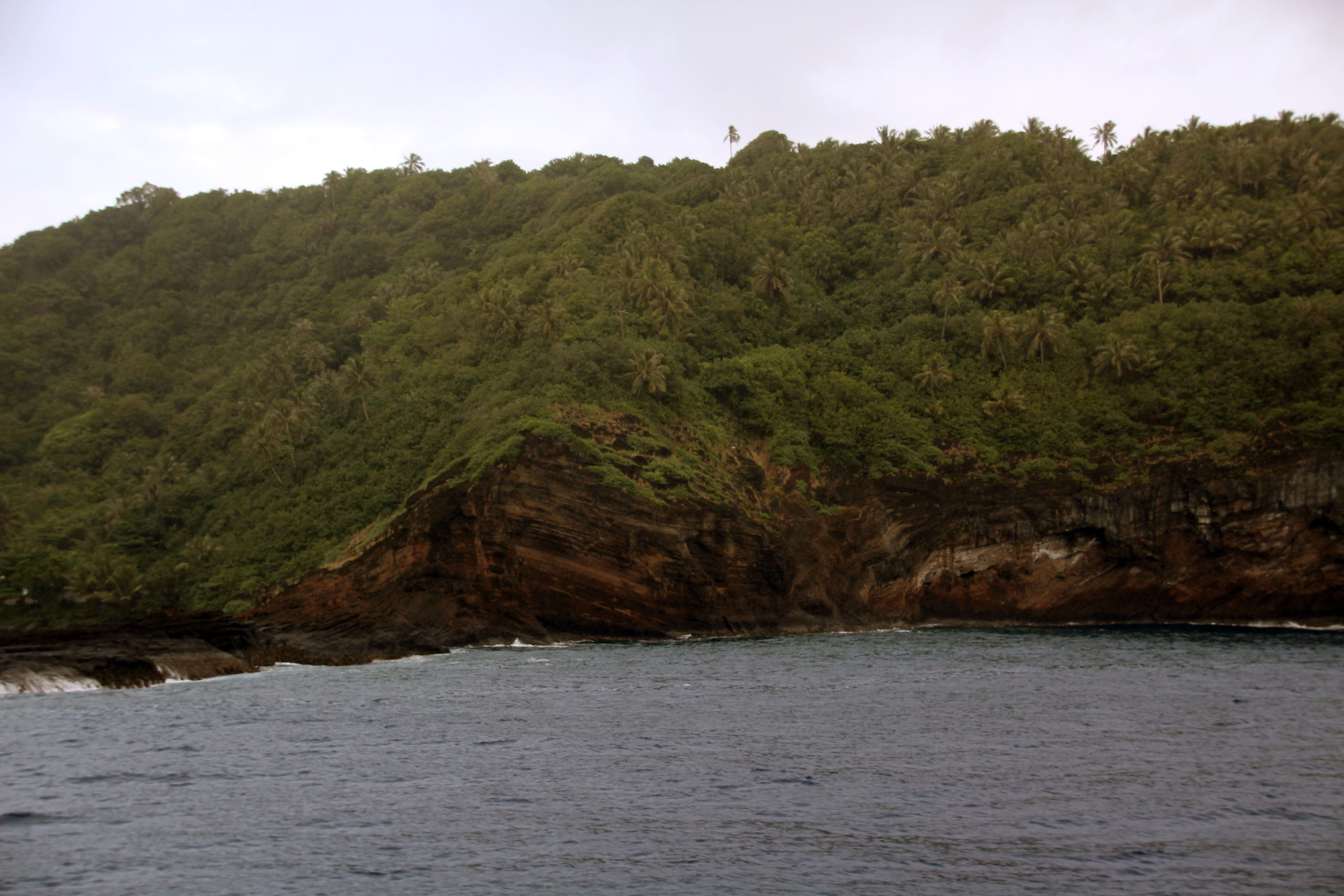
View of part of the tuff cone that contains both the village of Faleāsao and the port of Faleasao from the northwestern part of the island of Taʻū, American Samoa. A tuff cone can form when magma and water interact at shallow depth, causing localized explosions. The layers exposed inside the unvegetated cliff are the result of individual explosions during the eruption that created this tuff cone. The age of the eruption that formed this tuff cone is unknown. After the eruption, ocean waves and currents eroded (removed) the north side of the tuff cone, leading to the creation of Faleasao Port. The village of Faleāsao is also located in the tufa cone.
Current earthquake monitoring is based on the number and relative size of earthquakes and the estimated distance of earthquakes from the microseismometers. Due to the limitations of the current earthquake monitoring equipment, the exact location, depth, and magnitude of these earthquakes are unknown.
Hazards
It is unclear if this unrest will escalate to a volcanic eruption. An eruption could pose significant hazards to residents of American Samoa; these hazards include volcanic gases, low-level localized explosions of lava, lava flows, earthquake shaking, and tsunami.
Source : HVO
Photos : USGS , USGS / N. Deligne.
Iceland , Meradalur :
August 19 , 2022.
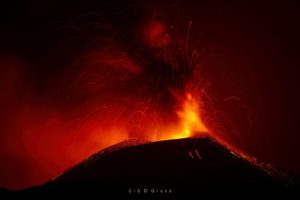
The eruption in Meradalir is going to end in next few days
Today (19-August-2022) there hasn’t been any lava flow seen from the crater in Merdalir valley in Fagradalsfjall mountain according to University of Iceland, Earth Science on Facebook. Few splashes of lava have been seen coming from the crater. This has also been observed on web cameras watching the eruption. Harmonic tremor has also dropped considerably since yesterday (18-August-2022) and continues to drop.
When the eruption ends exactly is unclear, but it might happen in the next few days.
The last flight measurements were taken on August 16 and are based on the following. Small changes over the past three days have somewhat ended the eruption. The attached map shows the distribution and thickness of the lava that has formed since August 3. The embedded image shows where the lava is in relation to the lava from last year’s eruption. The large image shows the edge of the new lava (purple line) and its thickness. At the crater level, the thickness in many places is 20-30 meters and up to 40 m in the arms of the crater. In the Meradalum valleys outside the crater area, the thickness in many places is 5 to 15 meters. The total volume is estimated to be around 12 million cubic meters, or about 8% of the material that occurred in last year’s eruption.
The new lava sits like waste on top of the old. As mentioned, there is still molten rock below the surface in the ancient lava field. Throwing the new one pushes the prey to the sides, so the surface of the old lava, east of the Meradalur Valleys, has been lifted several meters. The elevation rises to 3-5 meters (see map) both north and south of the new lava field.
The éruption has been reduced significantly recently and it is unclear how long it will last.
Source : jardvis.hi.is , icelandgeology.net .
Photo : Capture écran Twitter / Brett Carr.
Indonesia , Merapi :
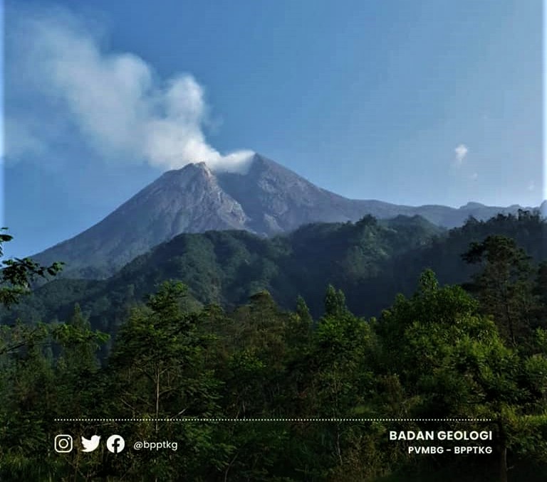
Report on the activity of Mount Merapi from August 12 to 18, 2022, Published on August 19, 2022
RESULTS OF OBSERVATIONS
Visual
The weather around Mount Merapi is usually sunny in the morning and afternoon, while the evening is foggy. White smoke, thin to medium thickness, low pressure and 100 m high was observed from the Mount Merapi observation post of Babadan on August 18, 2022 at 13:00 WIB.
This week, 23 lava avalanches were observed in the Southwest, descending the Bebeng River with a maximum slip distance of 1,800 m.
On the Southwest dome, there is no change in the height of the dome. For the central dome, no significant morphological change was observed. Based on photo analysis, the volume of the dome is still calculated at 1,664,000 m3, and for the central dome it is 2,772,000 m3.
Seismicity
This week, the seismicity of Mount Merapi showed:
36 shallow volcanic earthquake (VTB),
450 multi-phase earthquakes (MP),
1 low frequency earthquake (LF),
407 avalanche earthquakes (RF),
58 emissions earthquake (DG),
15 times tectonic earthquake (TT).
The intensity of this week’s seismicity is still quite high.
Deformation
Mount Merapi’s deformation that was monitored using EDM and GPS this week showed no significant changes.
Rain and lahars:
This week, it rained at the Mount Merapi observation post with a recorded rain intensity of 52 mm/hour for 60 minutes at the Kaliurang post on August 14, 2022. There were no reports of lahars or flow additional in the rivers that have their source on Mount Merapi.
Conclusion
Based on the results of visual and instrumental observations, it is concluded that:
The volcanic activity of Mount Merapi is still quite high in the form of effusive eruption activity. The state of the activity is defined at the « SIAGA » level.
Source et photo : BPPTKG.
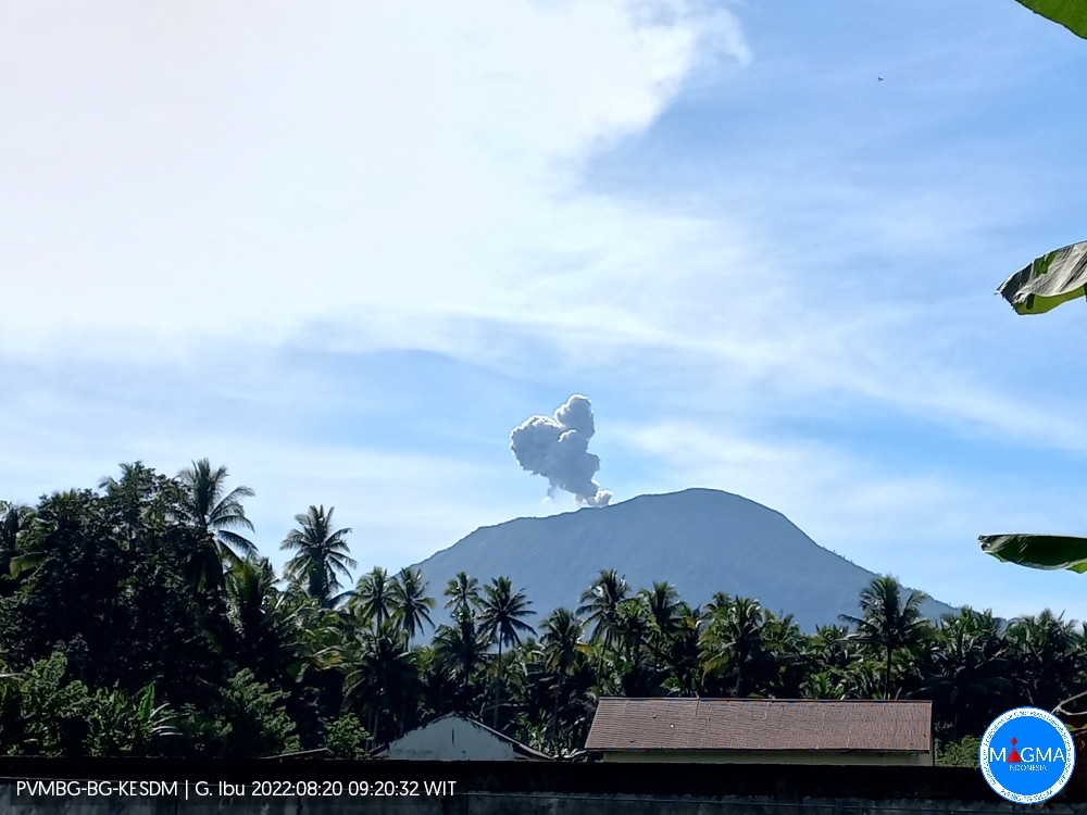
Indonesia , Ibu :
Mount Ibu erupted on Saturday August 20, 2022 at 09:17 WIT with an ash column height observed at ± 600 m above the summit (± 1925 m above sea level). It is observed that the ash column is gray in color with a thick intensity towards the West. This eruption was recorded on a seismograph with a maximum amplitude of 26 mm and a duration of 60 seconds.
VOLCANO OBSERVATORY NOTICE FOR AVIATION – VONA
Issued : August 20 , 2022
Volcano : Ibu (268030)
Current Aviation Colour Code : ORANGE
Previous Aviation Colour Code : orange
Source : Ibu Volcano Observatory
Notice Number : 2022IBU51
Volcano Location : N 01 deg 29 min 17 sec E 127 deg 37 min 48 sec
Area : North Maluku, Indonesia
Summit Elevation : 4240 FT (1325 M)
Volcanic Activity Summary :
Eruption with volcanic ash cloud at 00h12 UTC (09h12 local).
Volcanic Cloud Height :
Best estimate of ash-cloud top is around 6160 FT (1925 M) above sea level, may be higher than what can be observed clearly. Source of height data: ground observer.
Other Volcanic Cloud Information :
Ash-cloud moving to west.
Recommendation :
Communities around Mount Ibu and visitors/tourists should not travel within the 2.0 km radius and 3.5 km sectoral expansion to the crater opening in the northern part of Mount Ibu’s active crater. Ibu.
In the event of ash rain, people who are active outside the home are advised to use nose, mouth (mask) and eye (goggles) protection.
Source et photo : Magma Indonésie .