July 15 , 2022.
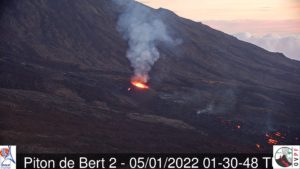
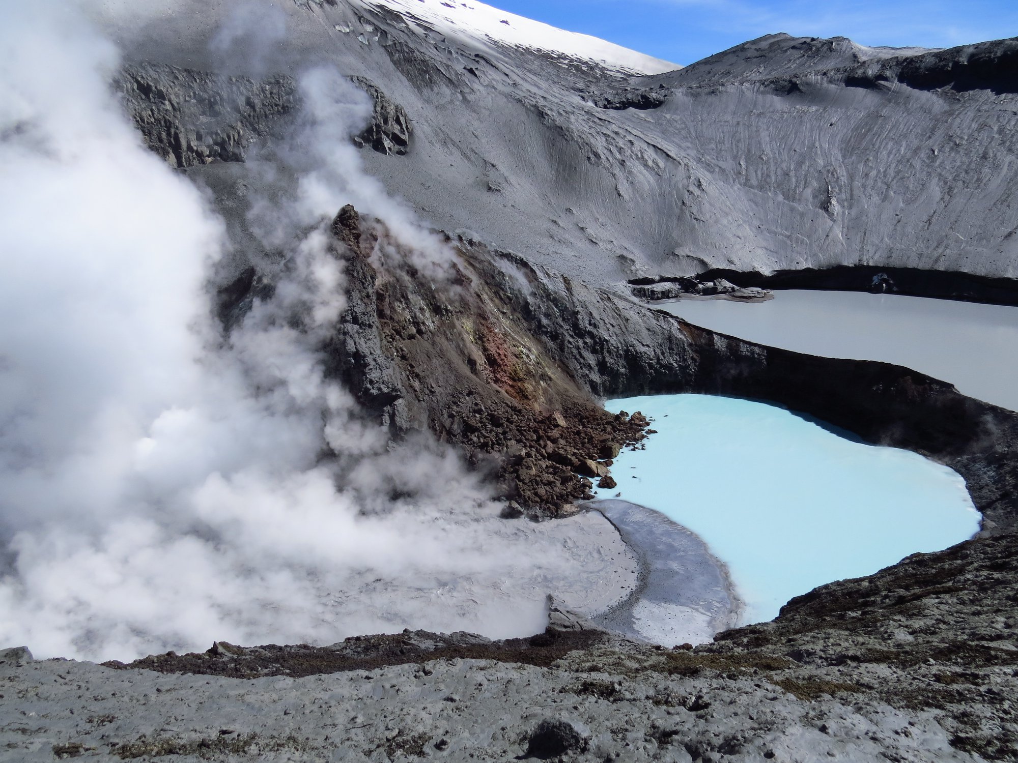
Chile , Copahue :
July 2, 2021, 5:20 p.m. local time (mainland Chile)
The National Geology and Mining Service of Chile (Sernageomin) discloses the following information obtained through the monitoring equipment of the National Volcanic Monitoring Network (RNVV), processed and analyzed at the Volcanological Observatory of the Southern Andes (ovdas) :
On July 2, at 2:00 p.m. UTC through the surveillance cameras installed around the volcano, a gaseous emission of intensity greater than the passive emission usually observable in the volcanic system was observed. The emission was maintained for about 2 hours with subtle changes in the color of the column, testifying to the presence of fine ashes, which was confirmed by the observation of a deposit on the south-eastern slope of the volcano .
Previous seismic activity began in late May with sporadic slight increases in continuous tremor, possibly related to crater lake depletion dynamics. This seismicity has been maintained for the past four days, with a slight trend of reduced displacements of less than 2 cm2, which have rapidly decreased today giving way to the reported surface activity.
Processing and analysis of Sentinel 2-L2A and Planet Scope satellite images show a significant decrease in the volume of the crater lake, consistent with the increase in the tremor signal and with the reporting of a thermal alert in the area associated with the crater, with a Volcanic Radiant Power (VRP) of 3 MW, on July 2, a value considered low according to data processed by MIROVA (http://www.mirovaweb.it/).
In addition, an anomaly was reported in the emissions of sulfur dioxide (SO2) into the atmosphere in the area near the volcanic edifice, corresponding to June 28, according to data published by the Tropospheric Monitoring Instrument (TROPOMI) and the Ozone Monitoring Instrument (IMO).
It is important to note that according to what has been observed in previous years, since 2018, the Copahue volcano has presented a cyclicity in its phases of instability, which are distinguished by an increase in surface activity from the month of July. During these periods, an increase in seismic signals was observed, associated with the depletion of the crater lake, which is accompanied by an increase in SO2 emissions and a subsequent increase in surface activity.
The above suggests that the current process would be associated with the early phase of a new cycle of minor volcanic activity, therefore, an increase in surface activity is expected which would involve processes such as the appearance of incandescence nocturnal and ash emissions, in line with those observed during previous cycles.
Source : Sernageomin
Photo : Cegemar , Sernageomin.
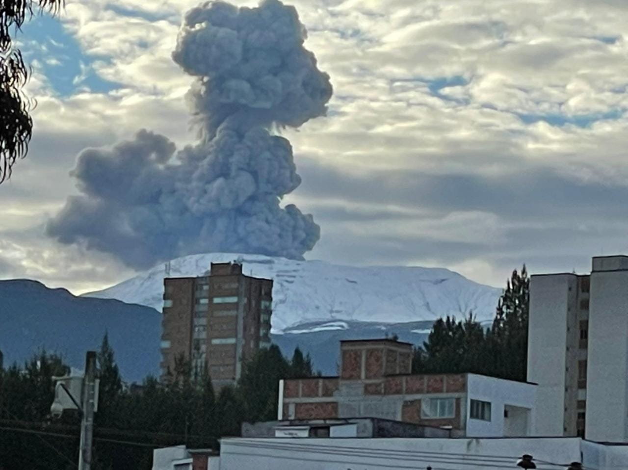
Colombia , Nevado del Ruiz :
Bulletin of activity level of the Nevado del Ruiz volcano.
The activity level continues at Yellow Activity Level or (III): changes in the behavior of volcanic activity.
Regarding the monitoring of the activity of the Nevado del Ruiz volcano, the COLOMBIAN GEOLOGICAL SERVICE reports that:
Seismicity related to fluid dynamics within volcanic conduits increased in number of earthquakes and maintained similar levels of seismic energy released, compared to the previous week. This seismic activity was characterized by the occurrence of continuous volcanic tremors, tremor pulses, long and very long period type earthquakes. In general, these signals exhibited moderate to low energy levels, variable spectral content, and were located primarily within Arenas Crater. Thanks to the cameras installed in the area of the volcano, as well as the report of the officials of the National Natural Park of Los Nevados and the personnel in the field, the confirmation of the gas and ash emissions associated with some of these seismic signals has been made. . Likewise, through the FLIR cameras (thermographic cameras) of the volcanic monitoring network, changes in the relative temperature of the emitted material have been observed.
The seismicity associated with the fracturing of the rocks decreased in number of earthquakes and showed an increase in the level of seismic energy released, compared to the previous week. This seismic activity was located mainly to the southeast and southwest of the volcanic edifice, on the border with the Nevado del Cisne volcano, and to a lesser extent in the Arenas crater. The depth of the earthquakes varied between 0.2 and 6.3 km. The maximum magnitude recorded during the week was 2.1 and 2.2 ML (Local Magnitude), corresponding to two earthquakes that occurred on July 9 and 10 at 9:32 a.m. and 7:17 p.m. (local time), located southeast of the crater Arenas, at a depth of 3.7 and 3.6 km, respectively.
Source : Ingeominas.
Photo : Ivan Jaramillo Nicholas
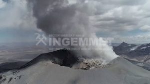
Democratic Republic of Congo , Nyamulagira :
Thermal anomalies from lava effusion on Nyamulagira’s crater floor were identified in satellite images on 6 and 11 July.

Virunga National Park – North Kivu. An interior view of the Nyamulagira volcano crater and its lava lake.
Africa’s most active volcano, Nyamulagira (also known as Nyamuragira), is a massive high-potassium basaltic shield about 25 km N of Lake Kivu and 15 km NE of the steep-sided Nyiragongo volcano. The summit is truncated by a small 2 x 2.3 km caldera that has walls up to about 100 m high. Documented eruptions have occurred within the summit caldera, as well as from the numerous flank fissures and cinder cones. A lava lake in the summit crater, active since at least 1921, drained in 1938, at the time of a major flank eruption. Recent lava flows extend down the flanks more than 30 km from the summit as far as Lake Kivu; extensive lava flows from this volcano have covered 1,500 km2 of the western branch of the East African Rift.
Sources : Observatoire Volcanologique de Goma (OVG), Sentinel Hub
Photo : — 02 avril 2015
Hawaii , Kilauea :
19°25’16 » N 155°17’13 » W,
Summit Elevation 4091 ft (1247 m)
Current Volcano Alert Level: WATCH
Current Aviation Color Code: ORANGE
Activity Summary:
The summit eruption of Kīlauea Volcano, within Halemaʻumaʻu crater, has continued over the past 24 hours. All recent lava activity has been confined to the crater and current data indicate that this scenario is likely to continue. No significant changes have been noted at the summit or in either rift zone.
Summit Observations:
Eruption of lava from the Halemaʻumaʻu western vent into the active lava lake has continued over the past 24 hours. The lava level in the lake has been steady at a relatively low level following summit deflation in recent days. Overnight webcam views showed that lava ooze-outs were absent over the past 24 hours and the intermittent, low-level spattering at the western vent has remained inactive. Measurements from an overflight on July 7, 2022 indicated that the crater floor had seen a total rise of about 130 meters (427 feet) . Summit tiltmeters have been generally flat over the past 24 hours, following a deflationary period that started in the late evening of July 9. A sulfur dioxide (SO2) emission rate of approximately 1,300 tonnes per day (t/d) was measured on July 11, 2022. Summit tremor is steady for this eruption’s long term base-line level.
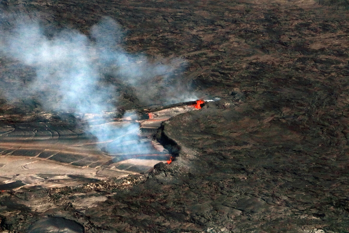
Minor spattering was visible in the east end of the lava lake within Halema‘uma‘u, at the summit of Kīlauea, on July 8. Sulfur dioxide is visible emanating from the lake surface (the bluish-colored fume). A sulfur dioxide emission rate of approximately 2,800 tonnes per day (t/d) was measured on July 8.
Rift Zone Observations:
No unusual activity has been noted along the East Rift Zone or Southwest Rift Zone; steady rates of ground deformation and seismicity continue along both. Measurements from continuous gas monitoring stations downwind of Puʻuʻōʻō in the middle East Rift Zone remain below detection limits for SO2, indicating that SO2 emissions from Puʻuʻōʻō are negligible.
Source : HVO.
Photo : UGSS / K. Mulliken.
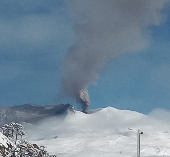
Guatemala , Fuego :
Weather conditions: partly cloudy
Wind: East
Precipitation: 24.00 mm.
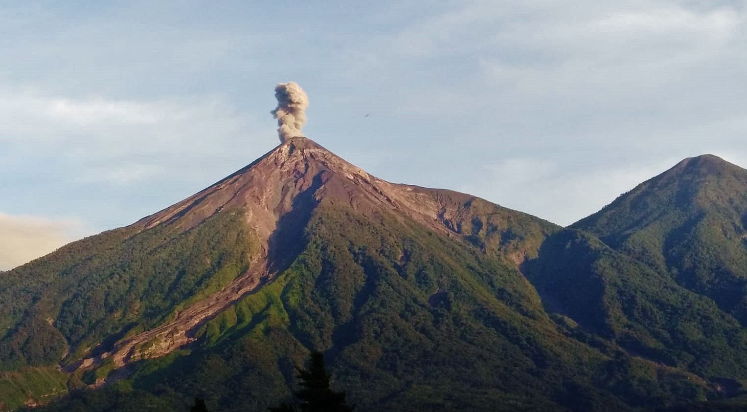
Activity :
The Fuego volcano observatory -OVFGO- reports 2 to 3 weak and moderate explosions per hour, these generate columns of ash at a height of 4,500 to 4,800 meters above sea level (14,763 – 15,748 feet) which extends approximately 10 to 15 km in a westerly direction due to the wind patterns. The explosions produce the descent of weak to moderate avalanches on the contour of the crater towards the ravines of Ceniza, Santa Teresa, Taniluya and Trinidad. Weak to moderate rumblings were generated which caused a weak shock wave which vibrated the houses near the volcano. Following the explosions, it is likely that ash will fall in the communities of Panimaché I, Panimaché II, Morelia, Santa Sofía, Finca Palo Verde, Sangre de Cristo, Yepocapa and others located west of the Fuego volcano. Light sounds similar to a train locomotive lasting 1 minute are reported.
Source : Insivumeh.
Photo : Conred