May 11 , 2022.
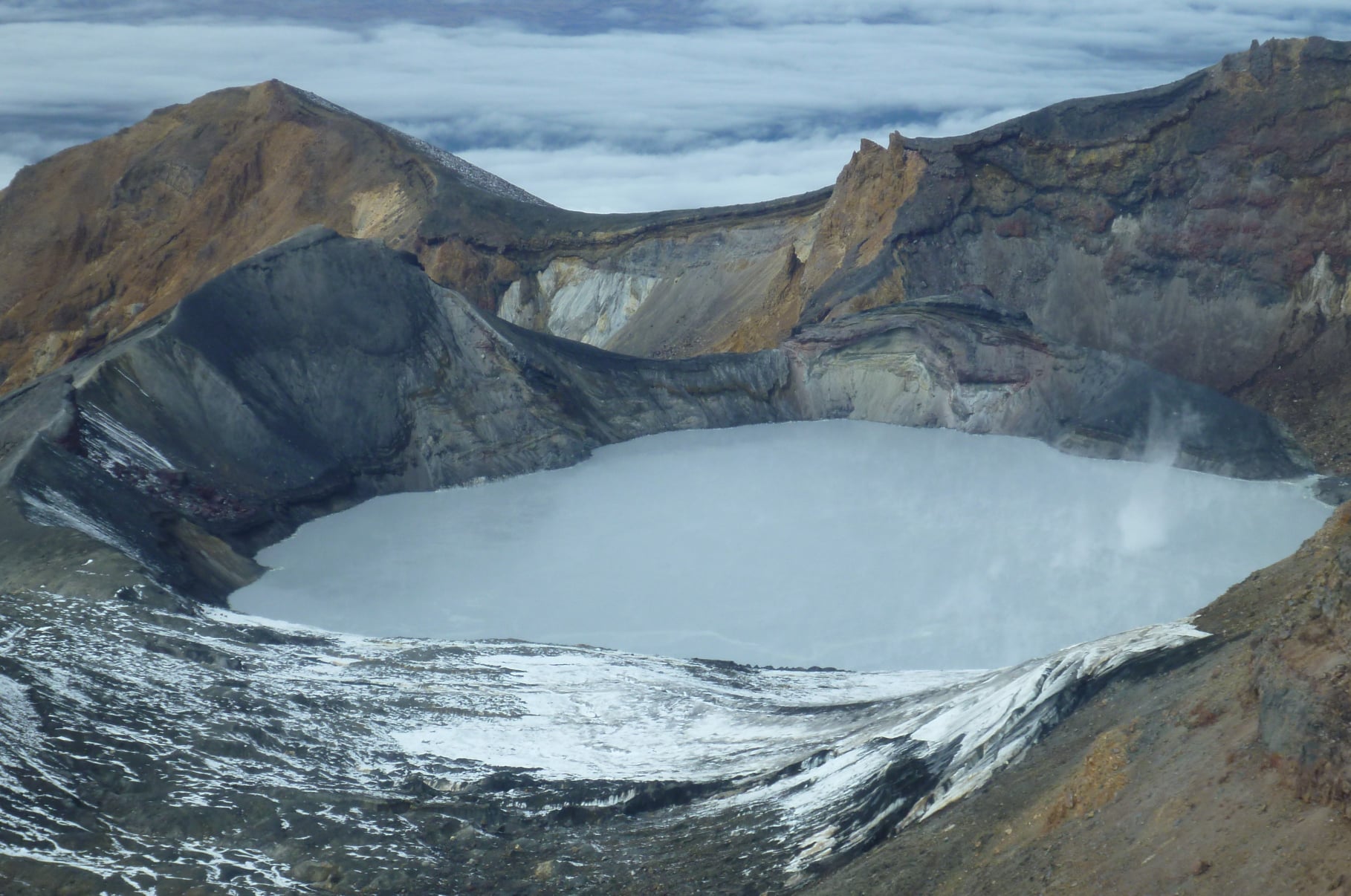
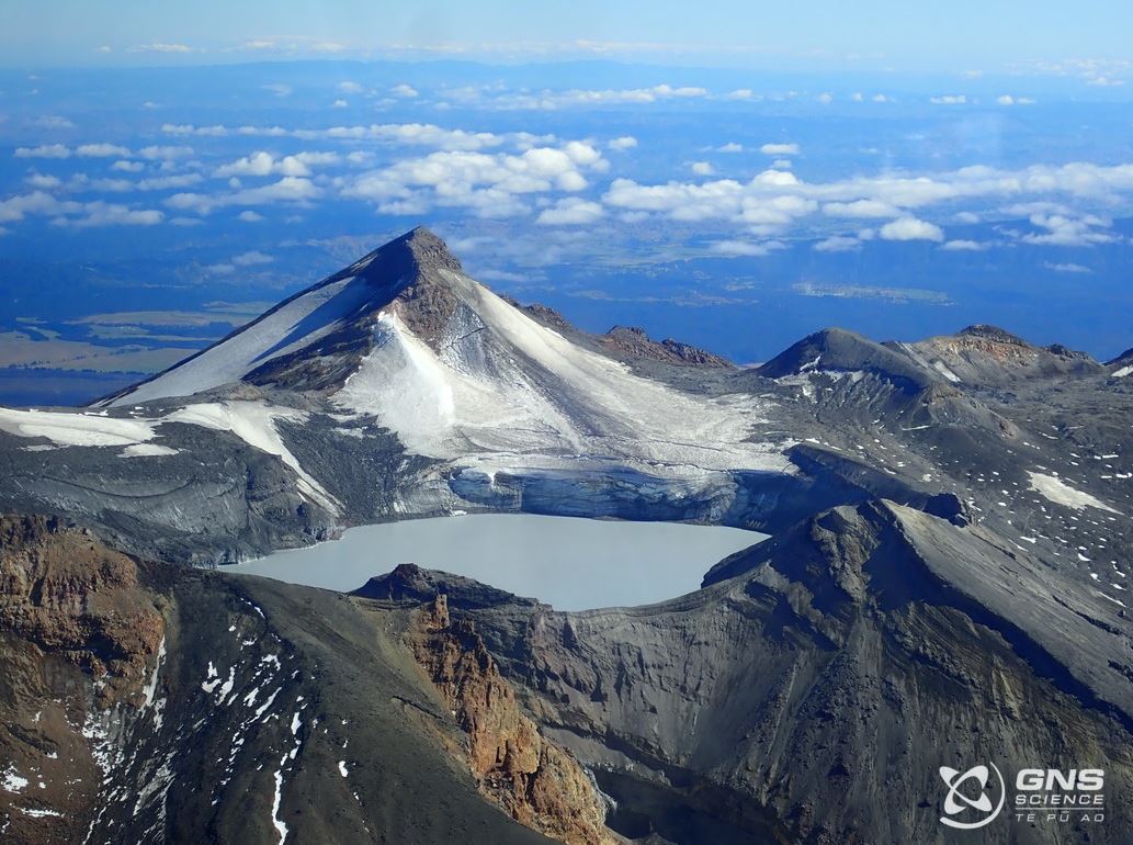
New Zealand , Ruapehu :
Heightened volcanic unrest continues at Mt Ruapehu with volcanic gas output, strong tremor and steam plumes: Volcanic Alert Level remains at Level 2. Published: Wed May 11 2022 10:00 AM
Aviation Colour Code remains at Yellow
High levels of volcanic gas emissions and strong volcanic tremor continue at Mt Ruapehu. The Crater Lake (Te Wai ā-moe) temperature has risen to 41°C and steam plumes can be observed in cold, still atmospheric conditions. The volcano is still at a heightened level of unrest. The Volcanic Alert Level remains at 2, with greater chances of eruption over the next four weeks than at Volcanic Alert Level 1.
Last week, steam plumes were observed over Mt Ruapehu’s Crater Lake (Te Wai ā-moe). Observation flights have confirmed these steam plumes were not caused by an eruption. Instead, they were related to a combination of increased heat flow at the crater lake and still, cold atmospheric conditions. Over the last 12 days the Crater Lake temperature has peaked at 41 °C following a four-week period at 36-38 °C. Our modelling suggests that maintaining the lake temperature and recent rise has required ~300-400 MW of heat energy.
Since early-March we have been recording strong volcanic tremor at Mt Ruapehu. This is the most sustained and vigorous volcanic tremor recorded in two decades, and it accompanied the rise in crater lake temperature. Although tremor levels remain high, there has been a decline in the tremor this last week.
Overall, the period of heightened volcanic unrest continues. Within the next four weeks, the most likely outcome of this unrest episode is minor eruptive activity that is confined to the lake basin, or no eruptions. This level of activity may generate lahars (dangerous volcanic mudflows) in the Whangaehu River. The next most likely scenario is a larger eruption that impacts the summit plateau with volcanic surges and generates lahars in multiple catchments, like what was seen after the September 2007 eruption, or older events like those in 1975 and 1969. An eruption of this size would cause life-threatening hazards on the summit plateau and in valleys impacted by lahars.
The chance of a prolonged eruptive episode or a larger eruption, such as occurred in 1995-96 with wider ashfall impacts, is higher than it was two months ago, but within the next 4 weeks remains very unlikely. Such an eruption would most likely only follow a sequence of smaller eruptions.
Due to the heightened volcanic unrest, GNS Science staff are carrying out more frequent aerial observations, gas measurements and Crater Lake sampling. A gas measurement flight on 4 May 2022 confirmed high sulphur dioxide (SO2) and carbon dioxide (CO2) fluxes, respectively of 260 and 1970 tonnes per day of gas. Both gases are indicator gases derived from relatively shallow magma bodies. Observations from the gas flight and 2 additional observation flights have confirmed upwelling of central vent and northern vent areas continues. Further flights will be conducted when weather conditions are suitable.
The high sulphur dioxide (SO2) and carbon dioxide (CO2) gas output and sustained strong volcanic tremor, continue to indicate that molten rock (magma) is driving this period of heightened unrest. Increasing Crater Lake temperature is reflecting the increasing upwelling of hot fluids and gases through the active vents. Available laboratory analysis of the latest Crater Lake fluid and gas samples show high temperatures in the hydrothermal system but no reaction with the magmatic material.
Our interpretation of the observational data and activity is consistent with elevated volcanic unrest at the heightened level and therefore the Volcanic Alert Level remains at Level 2. The Aviation Colour Code remains at Yellow.
Mt Ruapehu is an active volcano and has the potential to erupt with little or no warning when in a state of elevated volcanic unrest.
The Volcanic Alert Level reflects the current level of elevated volcanic unrest. The Volcanic Alert Level should not be used to forecast future activity. However, at Volcanic Alert Level 2, eruptions are usually more likely than at Volcanic Alert Level 1.
Source : Geonet / Brad Scott / Duty Volcanologist .
Photos : Geonet / Gns Science.
Alaska , Cleveland :
AVO/USGS Volcanic Activity Notice
Current Volcano Alert Level: ADVISORY
Previous Volcano Alert Level: UNASSIGNED
Current Aviation Color Code: YELLOW
Previous Aviation Color Code: UNASSIGNED
Issued: Tuesday, May 10, 2022, 4:19 PM AKDT
Source: Alaska Volcano Observatory
Notice Number: 2022/A502
Location: N 52 deg 49 min W 169 deg 56 min
Elevation: 5676 ft (1730 m)
Area: Aleutians
Volcanic Activity Summary:
Elevated surface temperatures and sulfur dioxide emissions have been detected in satellite data over the past couple of days, representing a departure from background activity. AVO is increasing the Aviation Color Code and Volcano Alert Level from YELLOW/ADVISORY.
Cleveland volcano is monitored with a limited real-time seismic network. This smaller network inhibits AVO’s ability to detect precursory unrest that may lead to an explosive eruption. Rapid detection of an ash-producing eruption may be possible using a combination of seismic, infrasound, lightning, and satellite data. Eruptions from Cleaveland typically generate small clouds of volcanic ash that are a hazard in the immediate vicinity of the volcano, though more significant ash emissions are possible.
Recent Observations:
[Volcanic cloud height] not applicable
[Other volcanic cloud information] not applicable
Hazard Analysis:
[Other hazards] elevated surface temperatures detected
[Volcanic gas] sulfur dioxide detected
Remarks:
Cleveland volcano forms the western portion of Chuginadak Island, a remote and uninhabited island in the east central Aleutians. The volcano is located about 45 miles (75 km) west of the community of Nikolski, and 940 miles (1500 km) southwest of Anchorage. The most recent significant period of eruption began in February 2001 and produced 3 explosive events that generated ash clouds as high as 39,000 ft (11.8 km) above sea level. The 2001 eruption also produced a lava flow and hot avalanche that reached the sea. Since then, Cleveland has been intermittently active producing small lava flows, often followed by explosions that generate small ash clouds generally below 20,000 ft (6 km) above sea level. These explosions also launch debris onto the slopes of the cone producing hot pyroclastic avalanches and lahars that sometimes reach the coastline.
Source : AVO.
Photo : Herstand, Malcolm / Alaska Volcano Observatory / Alaska Division of Geological & Geophysical Surveys
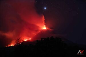
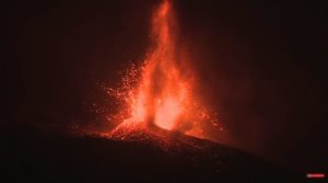
Italy , Stromboli :
WEEKLY NEWSLETTER, from May 02, 2022 to May 08, 2022. (issue date May 10, 2022)
ACTIVITY STATUS SUMMARY
In the light of the surveillance data, it is highlighted:
1) VOLCANOLOGICAL OBSERVATIONS: In this period a normal explosive activity of Strombolian type was observed. The total hourly frequency of explosions oscillated between low values (4 events/h) and average values (10 events/h). The intensity of the explosions was low and medium in the area of the North crater and low in the area of the Center-South crater.

2) SEISMOLOGY: The seismological parameters monitored do not show any significant variations, with the exception of the seismic signal, with LP component, recorded at 12:03 (UTC) on May 7.
3) SOIL DEFORMATIONS: The island’s soil deformation monitoring networks did not show any significant variation.
4) GEOCHEMISTRY: SO2 flux at a medium-low level, CO2 fluxes remain at medium-high values, the C/S value remains at high values of around 20.
Finally, the value of the isotopic ratio of Helium dissolved in the thermal aquifer shows an increase reaching the value of 4.38 R/Ra during the last sampling on April 26, 2022.
5) SATELLITE OBSERVATIONS: The thermal activity observed by satellite was at a low level.
VOLCANOLOGICAL OBSERVATIONS
Observations in the field with the in situ inspections of May 5 and 7.
As part of the activities of the DPC/INGV Annex A convention and the UN departmental project, 2 inspections were carried out in the summit area on May 5 and 7 in order to make findings using drones from the area. of the crater and characterize its morpho-structural arrangement. Through data analysis, DSM (Digital Surface Model; Figure 3.1 A) was obtained from the crater area with a resolution of 45 cm and two ortho-mosaics with a resolution of 11 cm (Figure 3.1 B) and 53 cm (Figure 3.1C). During the inspection on May 5, the activity was mainly characterized by light explosions of black ash.
In detail, sector CS1 and sector N1 produced explosions emitting fine materials (ash) sometimes mixed with coarse materials (bombs, even of decimetric dimensions; figure 3.1 D – E) while sector N2 was characterized by a pulsed degassing (puffs). On May 7, the cloud cover allowed a discontinuous observation of the activity, but in general it was observed that the activity was of less frequency and intensity than the day before.
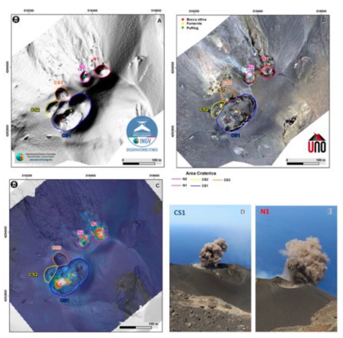
During the observation period, the eruptive activity of Stromboli was characterized through the analysis of images recorded by the INGV-OE surveillance cameras (altitude 190 m, Punta Corvi, altitude 400 m and Pizzo ). The explosive activity was mainly produced by 3 (three) eruptive vents located in the North crater area and 2 (two) eruptive vents located in the Center-South crater area. All the mouths are located inside the depression which occupies the terrace of the crater.
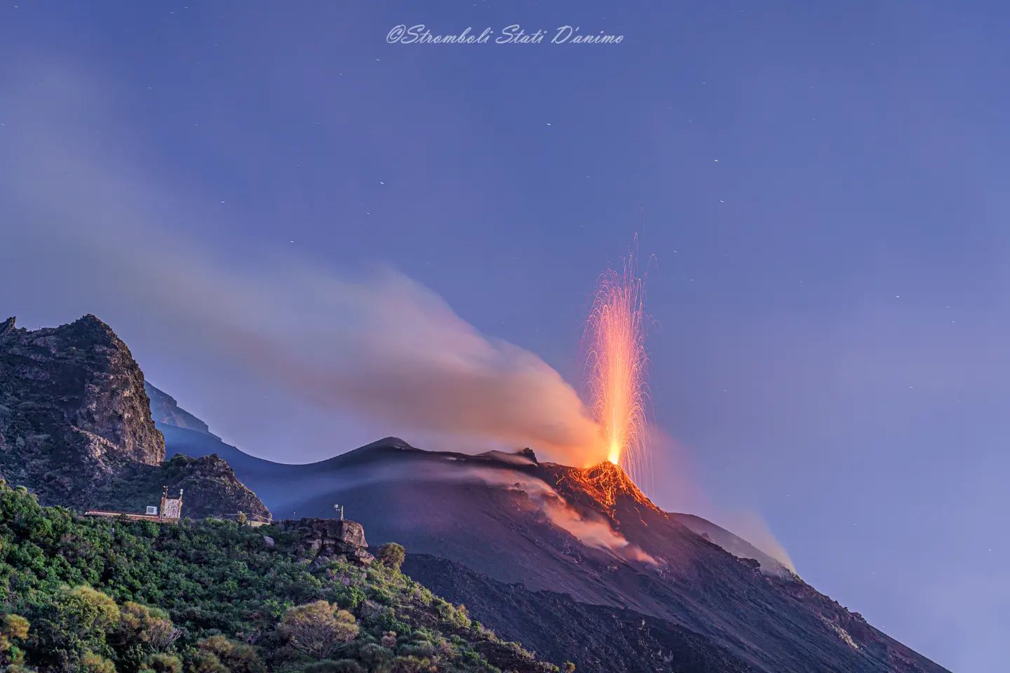
Sector N1 located in the area of the North crater produced explosions mainly of low intensity (less than 80 m high) and medium (less than 150 m high) emitting coarse materials (lapilli and bombs) mixed with fine materials (ashes). Sector N2, with two emission points, showed low intensity explosive activity (less than 80 m in height) emitting coarse materials. The average frequency of explosions varied between 3 and 6 events/h.
In the Center-South zone, sectors C and S1 did not show significant explosive activity. Sector S2, with two emission points, showed mainly low intensity explosions (less than 80 m high) emitting coarse materials mixed with fine materials. The frequency of the explosions varied between less than 1 and 5 events/h.
Source : INGV.
Photos : INGV , Stromboli Stati D’animo.
Colombia , Purace :
Weekly bulletin of the activity of the Puracé volcano – Los Coconucos volcanic chain.
The activity level of the volcano continues at the Yellow Activity Level or (III): changes in the behavior of volcanic activity.
From the analysis and evaluation of the information obtained through the monitoring network of the Puracé volcano – Los Coconucos volcanic chain, during the week of May 3 to 9, 2022, the COLOMBIAN GEOLOGICAL SERVICE – Volcanological and Seismological Observatory of Popayan reports that:
With regard to the number and the energy released by the recorded seismic events, a stable behavior was observed, compared to the previous weeks. For the period evaluated, 512 seismic events were recorded, of which 75 were associated with rock fracturing processes (type VT) and 437 with fluid dynamics in volcanic conduits; of these, 329 were classified as long period type events (LP type), three (3) as hybrid events (HB type), 12 as low frequency events (BF type), eight (8) as » Tornillos » (TO type) and 85 in the form of low energy tremor pulses (TR type).
The geodetic network of GNSS (Global Navigation Satellite System) stations for monitoring ground deformation continues to record a process associated with inflation.
Regarding volcanic gas monitoring, sulfur dioxide (SO2) flux emissions recorded by telemetry and field stations, showed stable behavior
compared to the previous week, reaching flow values in the mobile instrument of 1841 t/day for May 4 and a flow in the permanent stations with a maximum emitted of 727 t/day. The other gas analysis instruments in the volcanic influence zone do not show any relevant changes for the evaluated period.
In the follow-up of surface activity, the images obtained during the week thanks to the Mina, Lavas Rojas and Cerro Sombrero web cameras showed degassing of the volcanic system, with a white column oriented preferentially towards the North-West.
Sensors monitoring magnetic and electric fields and infrasonic waves did not record variations associated with changes in volcanic activity.
Therefore, it is concluded that significant variations in volcanic activity continue to be recorded, in accordance with the behavior expected at activity level III (yellow level), which could evolve towards states of greater activity. The Colombian Geological Service continues to monitor the evolution of the volcanic phenomenon and will report any changes that may occur in due course.
Source et photo : SGC.
Iceland , Reykjanes Peninsula :
Earthquake activity is ongoing in the Reykjanes peninsula. At 2:32AM last night a magnitude 3.2 was located around 7 km north of Reykjanestá, the earthquake was felt in the surrounding area. A M3.0 was recorded Monday night at 22:55 in the same location.
A magnitude 3.2 earthquake was detected just east of Grimsey north of Iceland early yesterday morning. The event is a part of a small swarm which has been ongoing today.
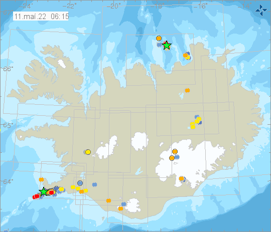
Around 2,200 earthquakes were located by the SIL system this week. Of those 2,200 events around 850 have been manually reviewed. The highest activity was on the Reykjanes Peninsula and was widely spread over the area. Distinctive swarms have been located by the Reykjanes Power plant, Eldvörp, Sundhnjúkagígar, Hagafell east of mount Þorbjörn, and lake Kleifarvatn. Three earthquakes above magnitude 3 were recorded at lake Kleifarvatn, one just after midnight on Thursday May 5th, and two on Saturday May 7th. All three earthquakes were felt in the capital area. Outside of Reykjanes, earthquake activity was observed e.g. in Bárðarbunga, Langjökull, and in Öxarfjörður. Two small events were detected around Hekla.
Source et photo : Vedur is .