January 13 , 2024.
Iceland , Grímsvötn / Reykjanes Peninsula :
Grímsvötn
Flood tremor gradually increasing No Earthquake Activity in Grímsvötn Since Yesterday. Updated 12. January at 10:30 UTC
In the last two days, the water level of Gígjukvísl has been steadily and significantly increasing. This is evident in the river, which is spreading out and widening in its channel, and by the water level gauge at the bridge crossing of the national Highway 1, which indicates that the water surface beneath it has risen by about 70 cm in two days. The conductivity in the river has also slightly increased, indicating signs of an increased amount of glacial outburst flood water in the river.
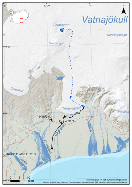
Map showing the floods pathway from Grímsvötn down to Skeiðarársandur
No earthquake activity has been detected in Grímsvötn or along the subglacial flood path beneath Skeiðarárjökull since yesterday. Seismic tremor from the flood exhibits a consistent increase in strength at the Grímsfjall seismometer, suggesting that the water outflow is still increasing from Grímsvötn. It is still expected that the glacial outburst flood in Grímsvötn will reach its peak flow around or shortly after the weekend, and in Gígjukvísl 1-2 days later.

Image 2: Average seismic amplitude measurements at Grímsfjall over the past 10 days. The blue curve illustrates that tremor from the glacial outburst flood has been steadily increasing in the past few days, exhibiting strong frequencies between 2 and 4 Hz. The ground vibration (tremor) contains a range of frequencies and it has proven to be useful to analyze it in different frequency intervals, so the signal is band-pass filtered for three different frequency bands (ranges). They are shown in different colors, 0.5 – 1.0 Hz (violet), 1.0 – 2.0 Hz (green), and 2.0 – 4.0 Hz (blue). It is often helpful to have these three different ranges to analyze of which origin the detected signal is.
The Icelandic Meteorological Office, along with scientists from the Institute of Earth Sciences at the University of Iceland, will continue to monitor Grímsvötn. The next news update can be expected on Monday, January 15, unless changes in activity arise over the weekend. The Meteorological Office’s 24-hour monitoring team will keep a close eye on the area and issue notifications earlier if necess
Reykjanes Peninsula:
Continued likelihood of an eruption at the Sundhnúksgígar crater row. Updated hazard assessment map issued
Updated 12 January at 17:45 UTC
The Icelandic Meteorological Office has updated the hazard assessment map for the Grindavík – Svartsengi region due to the ongoing unrest on the Reykjanes Peninsula. As before, the map shows an assessment of existing hazards that could occur with little warning within the specified regions. Note that the assessment applies only for hazards within the defined areas, although hazards are possible beyond the confines of the assessed regions.
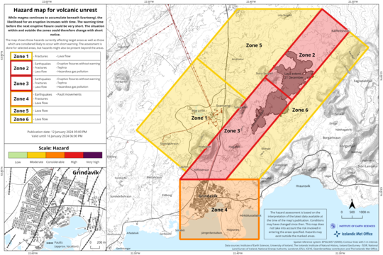
In terms of colour-coding, the overall assessment for the six zones remains unchanged from the previous map. However, there is a change in the hazard assessment associated with fissures within Grindavík (zone 4). The hazards associated with sudden opening of mapped and unknown fissures within Grindavík is now deemed higher. It should be noted that the hazards associated with fissures is limited to known areas within the municipal boundaries.
Unless otherwise stated, the map is valid until Tuesday, 16 January 2024.
Source et photos : IMO.
Indonesia , Kerinci :
Press Release on the VOLCANIC ACTIVITY of G.KERINCI
Mount Kerinci administratively belongs to Kerinci Regency, Jambi Province, and Solok Regency, West Sumatra Province. The geographical position of its summit is at latitude -1,697°N, longitude 101,264°E and has a height of 3,805 meters above sea level and its width reaches 18 km. Kerinci is the highest and largest volcano in Indonesia.
Mount Kerinci is a stratovolcano composed of interstratified pyroclastic deposits and lava. The pyroclastic flow deposits contain pumice with a large volume and distribution, indicating that Mount Kerinci has experienced large-scale eruptions in the past.
The activity level of Mount Kerinci has been Level II (WASPADA) since September 9, 2007. Mount Kerinci is monitored visually and instrumentally from the Mount Kerinci observation post in Kersik Tuo village, Kayu Aro district, Kerinci regency, Jambi province.
The development of Mount Kerinci activities until January 13, 2024 at 8:00 a.m. WIB is as follows:
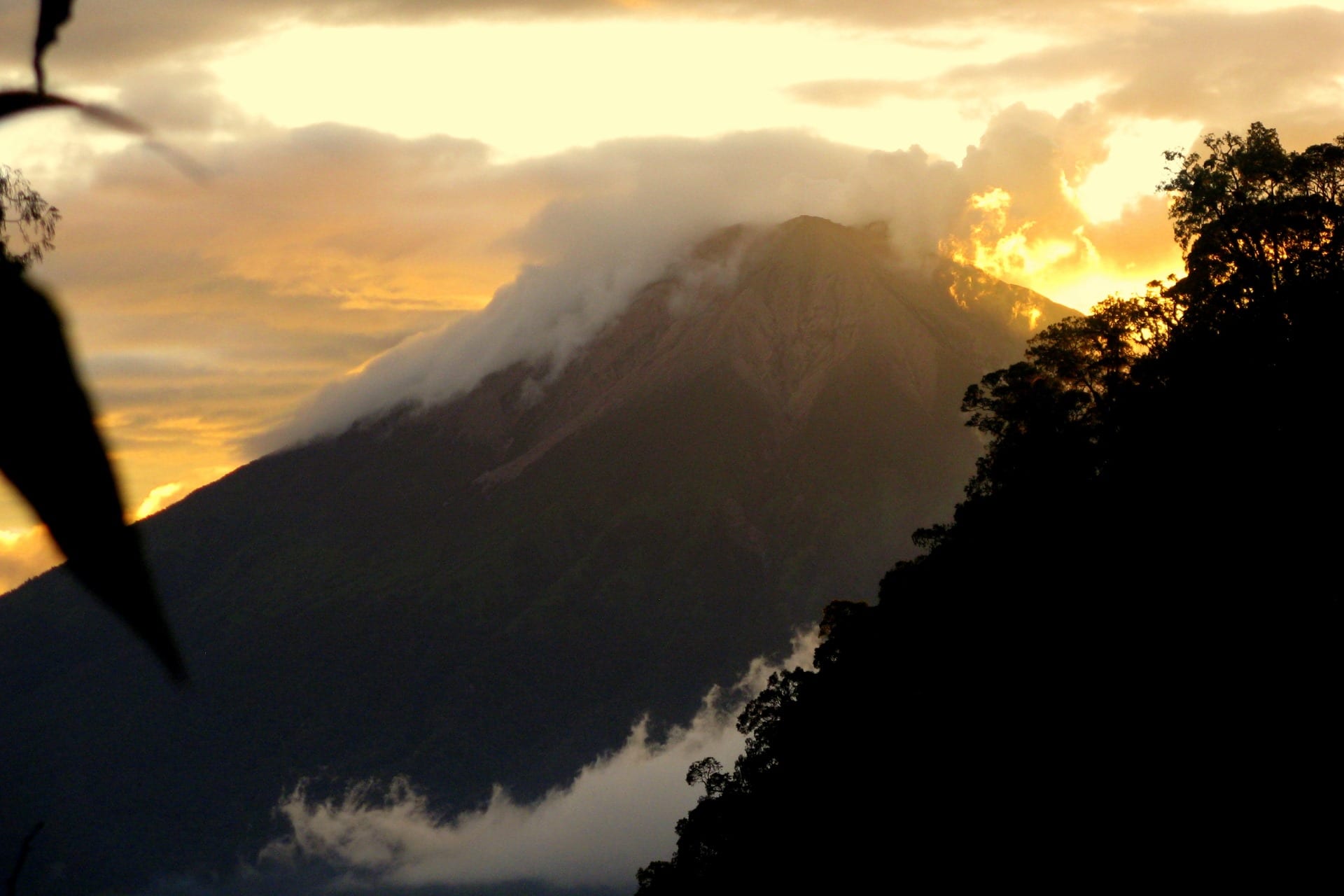
Visual observations towards the summit are usually covered by fog, when the weather is clear, a column of low intensity white gas is observed at a height of about 100-150 meters above the summit. The color of the exhaled gas indicates the dominance of water vapor, no rock/ash has risen to the surface.
Seismicity observations between January 1 and 13, 2024 were dominated by emission earthquakes with fluctuating numbers and the highest was 50 events on January 8, 2024, while on other dates the average was 30 events/day. 3 deep volcanic earthquakes were recorded and 2 shallow volcanic earthquakes were recorded during the same period.
On January 11 and 12, 2024, continuous tremor vibrations were recorded with a maximum amplitude of 0.5 to 1 mm (dominant value 0.5 mm). The appearance of these tremor vibrations indicates the movement of fluids (gas, liquid, rock solids) towards the surface, but until now, no visual change has been observed in the height and color of the gas exhaled from the crater . The RSAM graph shows fluctuations in a stable pattern indicating that no high energy earthquakes were recorded. It is suspected that currently volcanic activity still occurs in shallow magma reservoirs.
Based on the results of observations and analysis of visual and instrumental data until January 13, 2024 at 8:00 WIB, the activity level of Mount Kerinci is assessed as remaining at Level II (WASPADA), with the following recommendations :
The public and visitors/tourists should not approach and carry out activities within a 3 km radius of the summit crater of Mount Kerinci, due to the potential danger of expiration of high concentrations of volcanic gas, eruption of ashes and projection of stones around the summit, which can occur without being preceded by symptoms of clear increase in activity,
Source : PVMBG.
Photo : Wild Sumatra
Indonesia , Lewotobi Laki Laki :
VOLCANO OBSERVATORY NOTICE FOR AVIATION – VONA
Issued : January 12 , 2024
Volcano : Lewotobi Laki-laki (264180)
Current Aviation Colour Code : ORANGE
Previous Aviation Colour Code : orange
Source : Lewotobi Laki-laki Volcano Observatory
Notice Number : 2024LWK016
Volcano Location : S 08 deg 32 min 20 sec E 122 deg 46 min 06 sec
Area : East Nusa Tenggara, Indonesia
Summit Elevation : 5069 FT (1584 M)
Volcanic Activity Summary :
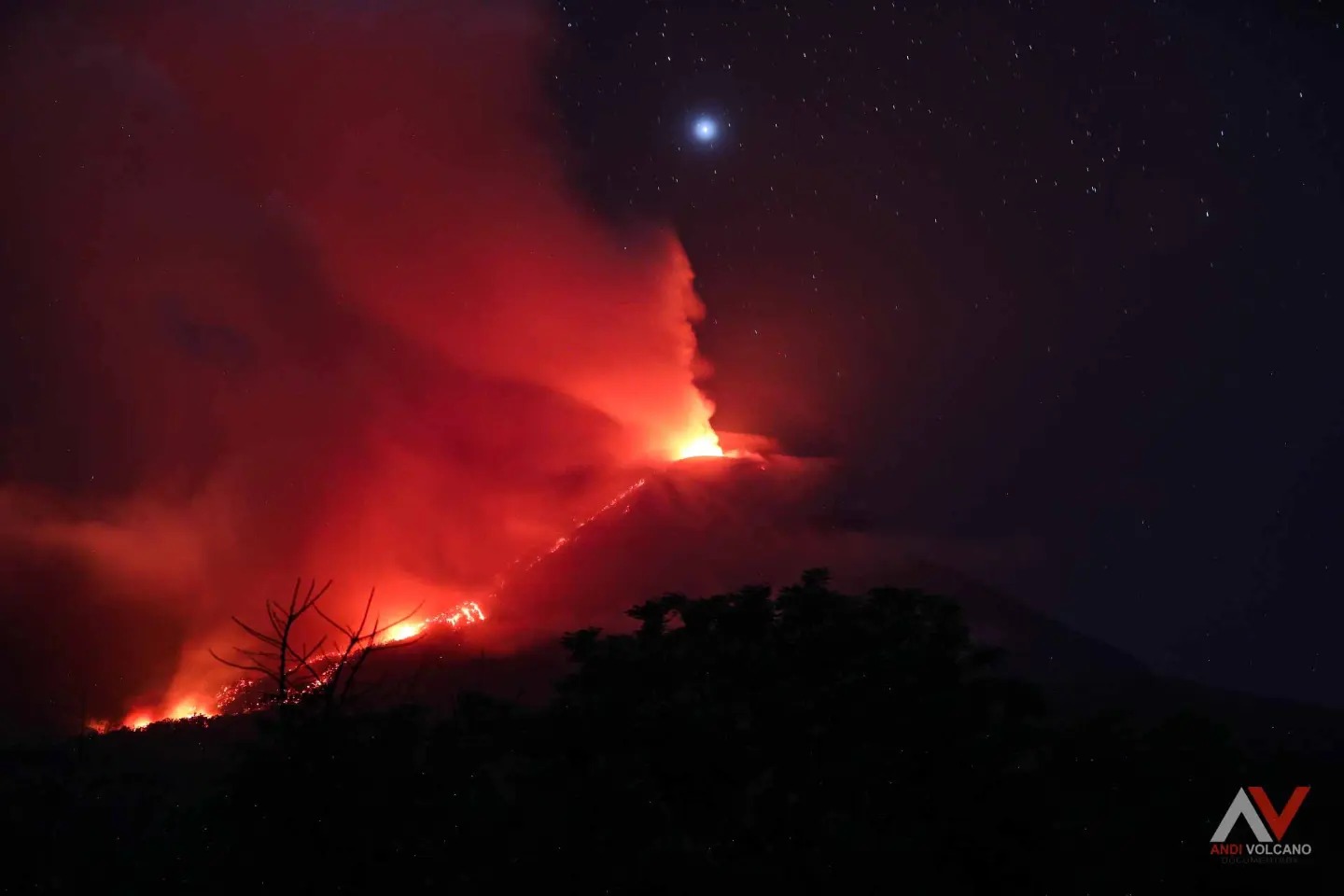
Eruption with volcanic ash cloud at 22h41 UTC (06h41 local).
Volcanic Cloud Height :
Best estimate of ash-cloud top is around 8269 FT (2584 M) above sea level or 3200 FT (1000 M) above summit. May be higher than what can be observed clearly. Source of height data: ground observer.
Other Volcanic Cloud Information :
Ash cloud moving from north to northeast. Volcanic ash is observed to be gray to brown. The intensity of volcanic ash is observed to be thick.
Remarks :
Tremor recorded on seismogram with maximum amplitude 14 mm.
Source : PVMBG
Photo : Andi Volcanist
Indonesia , Merapi :
Mount Merapi activity report from January 5 to 11, 2024
Published on January 12, 2024
OBSERVATION RESULT
Visual
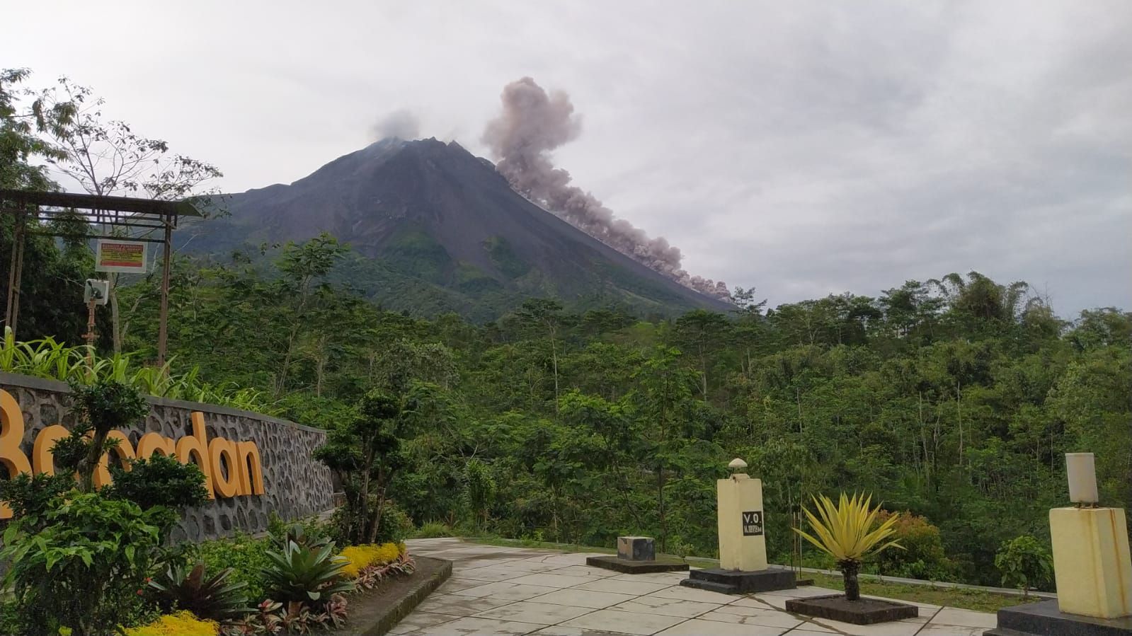
The weather around Mount Merapi is generally clear in the morning and evening, while it is foggy from noon to evening. White smoke, of low to thick thickness, low to moderate pressure and a height of 800 m was observed from the observation post on Mount Merapi in Selo on January 9, 2024 at 06:40 WIB.
This week, there were 4 warm cloud avalanches, 1 time in the South (upstream of the Boyong River) with a sliding distance of 1,000 m and 3 times in the Southwest (upstream of the Bebeng River ) with a maximum sliding distance of 1,500 m. Lava avalanches were observed 189 times in the South, South-West and West, including 8 times upstream of the Boyong River with a maximum distance of 1,500 m, 178 times upstream of the Bebeng River with a maximum distance of 1,800 m and 3 times upstream. of the Sat/Putih River with a maximum distance of 1,500 m. The sound of avalanches was heard 10 times from the Babadan post with low to moderate intensity.
It was observed that the morphology of the southwest dome had changed due to the activity of hot cloud avalanches and lava avalanches. The highest hot spot reached 338°C, lower than the previous measurement temperature. For the morphology of the median dome, no significant change was observed. Taking aerial photos of the central dome was not optimal because it was blocked by smoke. The highest hot spot reached 167.1°C, lower than the previous measurement temperature. Based on the analysis of aerial photos from January 10, 2024, the volume of the southwest dome was measured at 2,663,300 m3 and that of the central dome at 2,358,400 m3.
Seismicity
This week, the seismicity of Mount Merapi recorded:
4 warm cloud avalanches (APG),
115 multi-phase (MP) earthquakes,
1 low frequency earthquake (LF),
735 emissions earthquakes(RF),
10 tectonic earthquakes (TT).
The intensity of earthquakes this week is higher than last week.
Deformation
The deformation of Mount Merapi monitored by EDM and GPS this week did not show significant changes in deformation.
Rain and lahars
This week there was rain at Mount Merapi lookout post with a rain intensity of 82 mm/hour for 95 minutes at Kaliurang lookout post on January 5, 2024 and it was reported an increase in the flow of the Boyong River.
Conclusion
Based on the results of visual and instrumental observations, it was concluded that:
Volcanic activity at Mount Merapi is still quite high in the form of effusive eruptive activity. The activity status is set to the “SIAGA” level.
Source et photo : BPPTKG