April 30 , 2022.
Indonesia , Anak Krakatau :
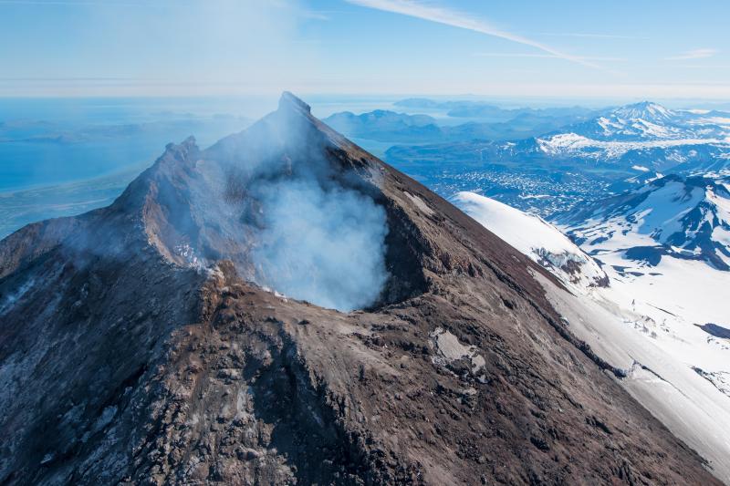
The head of the National Disaster Management Agency (BNPB), Lt. Gen. Tni Suharyanto conducted a field review using the Bell 412 helicopter to Mount Anak Krakatau, Regency of South Lampung, Lampung Province, Thursday (4/29). Also present were Pmk Minister Muhadjir Effendy, BMKG Chief Dwikorita Karnawati and PVMBG Chief Hendra Gunawan.
After the review, he said, the community must obey the determination of the areas included in the disaster-prone area (KRB) of Mount Anak Krakatau. KRB 1 with a radius of 7 kilometers from the top of the mountain, KRB 2 with a radius of 5 kilometers from the top of the mountain and KRB 3 with a radius of 2 kilometers.
« For people who are in KRB 1 zone, it is necessary to increase vigilance by not doing activities around the Singai valley in the peak zone, while in KRB 2, it is expected that the community is preparing to evacuate and await local government orders as recommended by the Ministry of Energy and Mineral Resources through the Geological Agency,” Suharyanto said after conducting the review.
He added that the special area of KRB 3 must be empty and there should be no activity in the area.
« Residents of KRB Zone 3 are not allowed to do activities and start preparing to evacuate (if there are residents), » he continued.
Not to mention he called on the community and local governments to increase preparedness and vigilance.
« The recommended efforts to the current area to carry out preparedness measures and readiness checks if one day the activation of the contingency plan that has been prepared is necessary, while for the community, to respond carefully and to remain vigilant,” Suharyanto said.
Source et photo : BNPB
Alaska , Pavlof :
55°25’2″ N 161°53’37 » W,
Summit Elevation 8261 ft (2518 m)
Current Volcano Alert Level: WATCH
Current Aviation Color Code: ORANGE
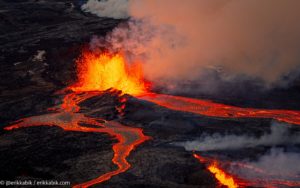
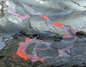
Pavlof Volcano continues to erupt from the east vent near the volcano’s summit. Seismic tremor, consistent with continued low-level activity, was present throughout the week and small explosions were observed on April 23. Elevated surface temperatures were observed during clear weather, and active lava flows were detected up to 500 m downslope from the vent. No ash emissions were observed in clear satellite or webcam images.
Periods of lava spatter and fountaining from the vent on the volcano’s upper east flank have been occurring since mid-November 2021. This activity has built a small cone and sent flows down the flank that melt the snow and ice and produce variable amounts of meltwater. The meltwater typically incorporates loose debris on the flank of the volcano and forms thin (less than 2 m thick) lahars. The lahar deposits extend down the east-southeast flank for several kilometers, not quite to the base of the volcano.
Previous eruptions of Pavlof indicate that the level of unrest can change quickly and the progression to more significant eruptive activity can occur with little or no warning.
Pavlof is monitored by local seismic and infrasound sensors, satellite data, web cameras, and remote infrasound and lightning networks.
Source : AVO.
Photo : Waythomas, Chris Alaska Volcano Observatory / U.S. Geological Survey( 2017).
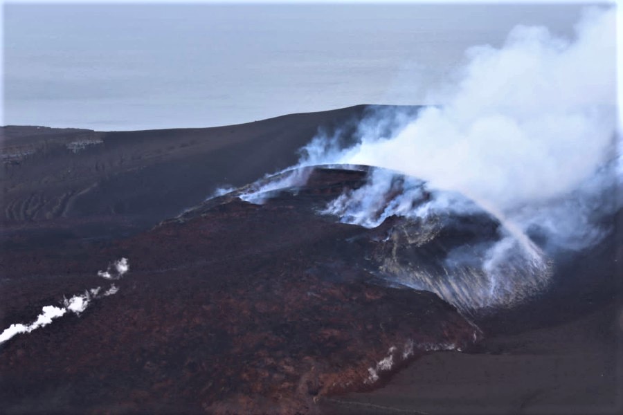
Philippines , Taal :
TAAL VOLCANO BULLETIN 30 April 2022 8:00 AM
In the past 24-hour period, the Taal Volcano Network recorded six (6) volcanic earthquakes including five (5) volcanic tremor events having durations of two (2) to seven (7) minutes and one (1) low-frequency volcanic earthquake. Activity at the Main Crater was dominated by the generation of plumes 900 meters tall that drifted west-northwest and west-southwest. Sulfur dioxide (SO2) emission averaged 12,943 tonnes/day on 29 April 2022. Temperature highs of 66.5°C were last measured from the Main Crater Lake on 27 April 2022. Based on ground deformation parameters from electronic tilt, continuous GPS, and InSAR monitoring, Taal Volcano Island and the Taal region has begun deflating in October 2021.
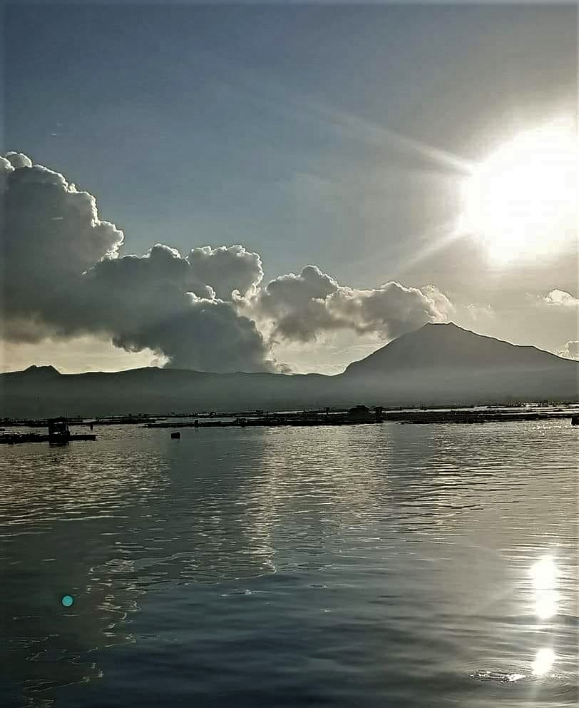
Alert Level 2 (Decreased Unrest) prevails over Taal Volcano. DOST-PHIVOLCS reminds the public that at Alert Level 2, sudden steam-driven or phreatic explosions, volcanic earthquakes, ashfall, and lethal accumulations or bursts of volcanic gas can occur and threaten areas within TVI and along its coast. Entry into TVI, Taal’s Permanent Danger Zone, must therefore be strictly prohibited.
Source : Phivolcs
Photo : Onin casal /Agoncillo ERT
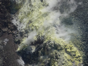
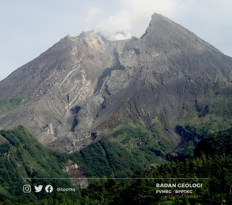
Indonesia , Merapi :
Merapi activity report from April 22 to 28, 2022.
– This week, 102 lava avalanches were observed southwestward, descending the Bebeng River with a maximum slip distance of 2,000 m.
– No significant morphological change was observed either in the cliffs or in the lava dome. The calculation of the volume of the Southwest dome obtained from aerial photographs is 1,567,000 m3, while the volume of the central dome of the crater cannot be measured because part of the dome is covered with smoke. Based on the photo analysis of the camera station, the volume of the central dome is fixed at 2,582,000 m3.
Seismicity:
This week, the seismicity of Mount Merapi recorded:
77 shallow volcanic earthquakes (VTB),
305 multi-phase earthquakes (MP),
594 avalanche earthquakes (RF),
18 emission earthquakes (DG),
11 tectonic earthquakes (TT).
– The intensity of seismicity this week is still quite high.
Mount Merapi’s deformation that was monitored using EDM this week showed a distance shortening rate of 0.9 cm/day.
– Rainfall intensity was 89 mm/hour for 100 minutes at Kaliurang Post on April 26, 2022. No lahar or additional flow was reported in the rivers that originate at Mount Merapi.
Conclusion:
1. The volcanic activity of Mount Merapi is still quite high in the form of effusive eruption activity. The state of the activity is defined at the « SIAGA » level.
2. The current potential danger is lava avalanches and hot clouds in the South-South-West sector covering the Boyong River for a maximum of 5 km, the Bedog River, Krasak, Bebeng for a maximum of 7 km. The Southeast sector covers the Woro River for a maximum of 3 km and the Gendol River for a maximum of 5 km. Meanwhile, the ejection of volcanic material in the event of an explosive eruption can reach a radius of 3 km around the summit.
Source : BPPTKG.
Photo :BPPTKG.
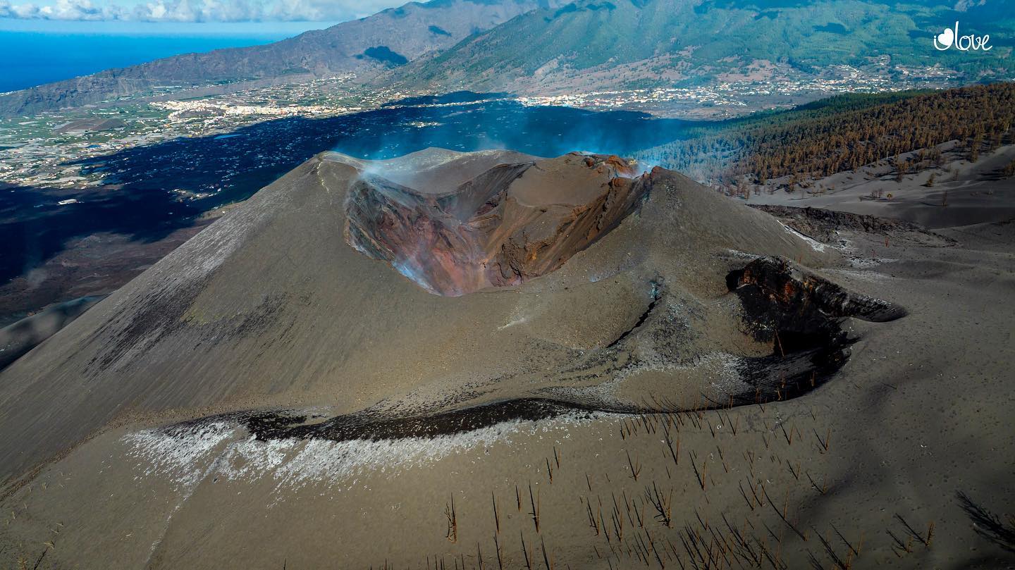
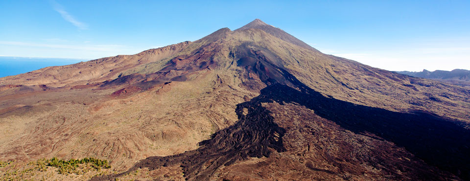
Canariy Islands , Cumbre Vieja / Tenerife / El Hierro :
Currently, the volcanic indicators of Tenerife, El Hierro, Lanzarote and Gran Canaria are in GREEN position.
Cumbre Vieja:
More than three months after the end of the eruption on the island of La Palma, the geophysical and geochemical parameters have still not returned to normal; its volcanic fire is therefore in the YELLOW position. This means that residents and visitors should continue to be attentive to communications from civil protection authorities.
Regarding seismicity, we find that last week the Canarian seismic network recorded 77 earthquakes of low magnitude, whose maximum value of 2.4 was linked to an earthquake located under the volcano of Cumbre Vieja and it happened last Wednesday April 27. The total seismic energy released last week in the archipelago was 1.3 gigajoules.
Regarding the deformation of the terrain, no significant variation was observed on any island during the past week. Regarding gas emissions and excluding the areas of La Bombilla and Puerto Naos, where abnormal emissions of carbon dioxide (CO2) continue to be recorded.
Seismic activity on Tenerife continues to indicate the presence of an active process in the central area of the island, with small swarms in Caldera Ucanca and under Pico Viejo, including one between 10 and 12 km in the area top of the top of the phonolithic chamber. On the other hand, yesterday and this morning there were deeper ones at 14-15 km where it is believed that the lower part of the said magma chamber is located and which indicates the response of this body of magma to the regional efforts which affect the island.
The geochemical network of the Canary Islands reflects that relatively higher diffuse emission values of volcanic gases are recorded in Tenerife, where we already know that from 2016 a process of pressurization of the volcanic-hydrothermal system is recorded. We have clarified that this process is normal in active volcanic systems and does not imply the possibility of a volcanic eruption in the short to medium term.
The appearance of an anomalous seismic signal detected south of El Hierro since November 25, and which had a similar aftershock this Sunday, suggests that something is happening under the ocean in the southern part of the island. .
These signals indicate a powerful process that is characterized by its long duration and shows us something that seems natural obviously due to its frequency spectrum, although it seems superficial. No associated earthquakes were located.
The first of the signals detected, more precisely that of November 25, remained active between 5 and 10 minutes, the second of the signals, that recorded on April 24, remained active from 5:00 p.m. to 11:00 p.m., as a very long signal and with some pulses or tremor but with a lot of noise which makes its precise localization even more difficult.