March 05 , 2022.
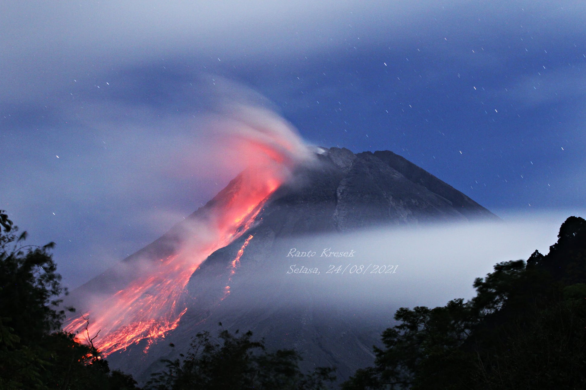
Indonesia , Merapi :
Merapi activity report, from February 25 to March 3, 2022.
– The weather around Mount Merapi is generally sunny in the morning and evening, while foggy in the afternoon.
– This week, lava avalanches were observed 73 times southwestward, descending the Bebeng River with a maximum slip distance of 2,000 m.
– Morphological analysis showed that there were morphological changes in the Southwest lava dome in the form of avalanches, but no significant elevation changes were observed. Also for the central dome, no change was observed. According to the analysis of aerial photos dated February 20, 2022, the volume of the Southwest lava dome is 1,578,000 m3 and the central dome is 3,228,000 m3.
– The intensity of seismicity this week is still quite high. It was recorded:
8 incandescent lava avalanches with a maximum sliding distance of 1,800 meters to the southwest.
– 104 avalanche earthquakes
– 2 emission earthquakes
– 1 distant tectonic earthquake
Mount Merapi’s deformation, which was monitored using EDM this week, showed a distance shortening rate of 0.4 cm/day.
Rainfall intensity of 26 mm/hour was recorded for 260 minutes at Kaliurang Post on March 3, 2022. No lahars or additional flow was reported in the rivers that originate from Mount Merapi.
Conclusion:
1. The volcanic activity of Mount Merapi is still quite high in the form of effusive eruption activity. The state of the activity is defined at the « SIAGA » level.
2. The current potential danger is lava avalanches and hot clouds in the South-South-West sector covering the Boyong River for a maximum of 5 km, the Bedog River, Krasak, Bebeng for a maximum of 7 km. The Southeast sector covers the Woro River for a maximum of 3 km and the Gendol River for a maximum of 5 km. Meanwhile, the ejection of volcanic material in the event of an explosive eruption can reach a radius of 3 km around the summit.
Source : BPPTKG.
Photo : Ranto Kresek
Hawaii , Kilauea :
19°25’16 » N 155°17’13 » W,
Summit Elevation 4091 ft (1247 m)
Current Volcano Alert Level: WATCH
Current Aviation Color Code: ORANGE
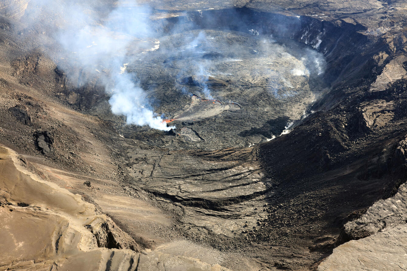
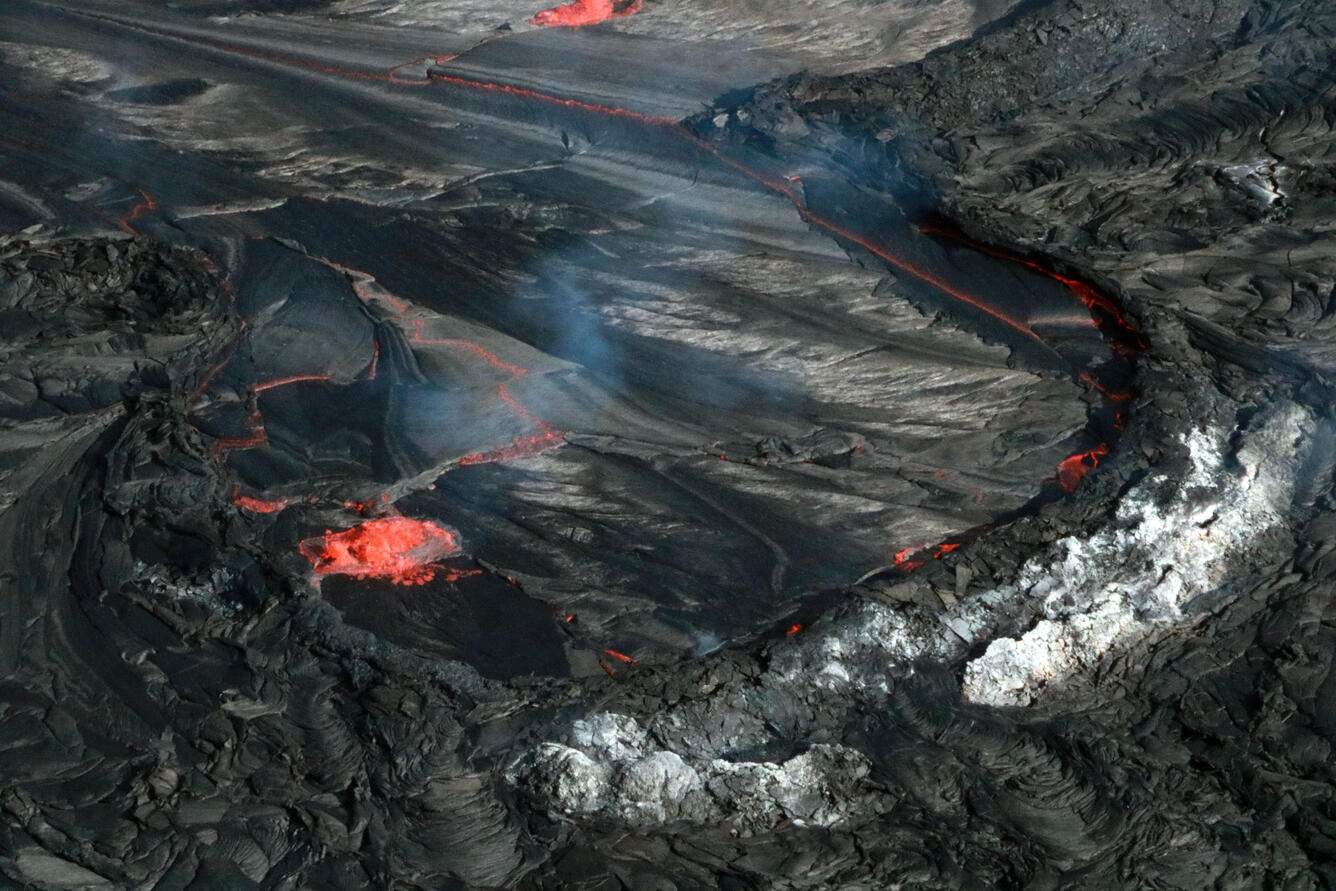
Aerial view of Halema’uma’u crater and the ongoing eruption inside. This view, looking northeast, shows one of many fallen blocks that formed during the 2018 Kīlauea summit collapse events. The collapsed block, which is in the foreground of the photo, has numerous cracks on its surface; the active vent is near the center of the image and is emitting volcanic gas.
Activity Summary:
The summit eruption of Kīlauea Volcano, within Halemaʻumaʻu crater, continues at this time. Tremor at the summit remains elevated and steady. Tilt at the summit of Kīlauea Volcano was slightly inflationary yesterday, becoming flat overnight. All activity remains confined to the active lava lake and west vent area within the western part of Halemaʻumaʻu crater with few ooze outs along the margins of the Halemaʻumaʻu crater floor. All recent activity has been confined to the crater, and there are no indications of activity migrating elsewhere on Kīlauea.
Halemaʻumaʻu Lava Lake Observations:
Eruption of lava from the western vent into the active lava lake within Halemaʻumaʻu crater continues with flows of active lava currently erupting from the west vent and spreading south, west, and east into the western active lava lake. There were few ooze outs along the margins of the crater floor over the past 24 hours. The highest point on the Halemaʻumaʻu crater floor has risen approximately 97 meters (318 feet) since the eruption began on September 29, 2021. The erupted volume is 45 million cubic meters (59 million cubic yards) of lava as measured on January 25, 2021.
Telephoto view of the distal (east) margin of the active lava lake in Halema’uma’u Crater at Kīlauea’s summit. Minor spattering is visible along the margin, as well as an area of crustal submersion (a process in which colder, denser crust on the surface sinks into the molten material below).
Summit Observations:
Summit tilt was slightly inflationary yesterday before becoming flat overnight. Tilt remains flat this morning. Seismic data shows that the volcanic tremor remains elevated and steady. Earthquake activity at the summit remains below background levels. A sulfur dioxide (SO2) emission rate of approximately ~2500 tonnes per day (t/d) was measured on February 25.
Source : HVO.
Photos : USGS/ F. Trusdell , K. Mulliken .
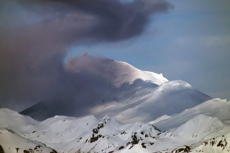
Alaska , Pavlof :
55°25’2″ N 161°53’37 » W,
Summit Elevation 8261 ft (2518 m)
Current Volcano Alert Level: WATCH
Current Aviation Color Code: ORANGE
The eruption of Pavlof Volcano continued throughout the last week producing a small lava flow on the volcano’s upper east flank. Lava effusion was associated with periods of continuous seismic tremor, elevated surface temperatures detected in clear satellite images, and confirmed by a clear high-resolution satellite image on Monday. No significant ash emissions were detected, but a light ash deposit was seen in the Monday satellite image close to the active vent. This is consistent with small explosions detected intermittently by infrasound arrays.
Periods of lava fountaining from the vent on the volcano’s upper east flank have been occurring since mid-November 2021. This activity has built a small cone and sent flows down the flank that melt the snow and ice and produce variable amounts of meltwater. The meltwater typically incorporates loose debris on the flank of the volcano and forms thin (less than 2 m thick) lahars. The lahar deposits extend down the east-southeast flank for several kilometers, not quite to the base of the volcano.
Previous eruptions of Pavlof indicate that the level of unrest can change quickly and the progression to more significant eruptive activity can occur with little or no warning.
Pavlof is monitored by local seismic and infrasound sensors, satellite data, web cameras, and remote infrasound and lightning networks.
Source : AVO
Photo : Snapp, Royce.
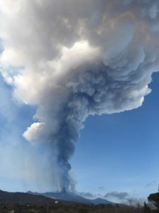
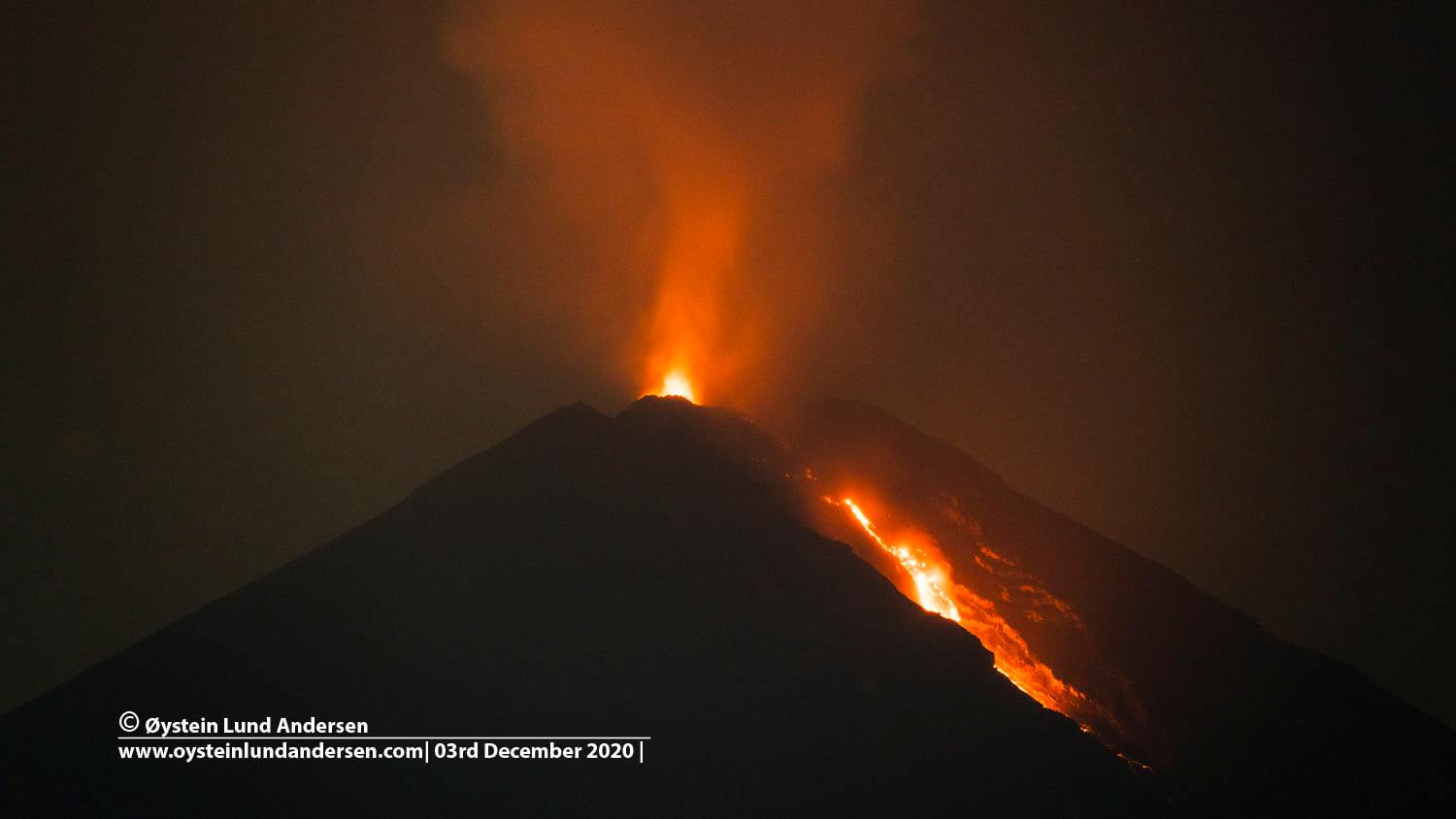
Indonesia , Semeru :
VOLCANO OBSERVATORY NOTICE FOR AVIATION – VONA
Issued : March 05 , 2022
Volcano : Semeru (263300)
Current Aviation Colour Code : ORANGE
Previous Aviation Colour Code : orange
Source : Semeru Volcano Observatory
Notice Number : 2022SMR45
Volcano Location : S 08 deg 06 min 29 sec E 112 deg 55 min 12 sec
Area : East java, Indonesia
Summit Elevation : 11763 FT (3676 M)
Volcanic Activity Summary :
Eruption with volcanic ash cloud at 00h24 UTC (07h24 local). Eruption and ash emission is continuing.
Volcanic Cloud Height :
Best estimate of ash-cloud top is around 13363 FT (4176 M) above sea level, may be higher than what can be observed clearly. Source of height data: ground observer.
Other Volcanic Cloud Information :
Ash-cloud moving to North.
It was observed that the eruption produced a gray-white colored eruption column with smoke 300-700 meters above the crater, facing east. The hot cloud avalanche occurred with an unobservable slip distance due to fog.
Earthquakes are related to magma and tectonic activity. It was recorded:
– 30 eruption earthquakes/explosions
– 2 hot cloud avalanche earthquakes
– 3 avalanche earthquakes
– 12 emission earthquakes
– 12 harmonic tremors
– 3 distant tectonic earthquakes.
Source : Magma Indonésie , PVMBG.
Photo : Oystein Lund Andersen .
Colombia , Nevado del Ruiz :
The director of environment and risk management of Tolima, Andrea Mayorquin, said that the ash fall varies in the department depending on the week, but at the moment it is in the direction of Caldas. For this reason, the Section Chief urged the community to be alert to any signs of activity.
“It is a threat that is latent and we have to live with the situation. The most important thing is knowing how to react because at any time there can be an eruption, » said manager Andrea Mayorquin.
It should be noted that the Colombian Geological Service publishes statements every day, with new warnings of ash emission by the Nevado del Ruiz volcano, falling more in certain populations that are around the volcano.
Andrea Mayorquín, director of the risk management department, gave details of the situation in the region and reiterated that people should be alert to any situation, because this volcano can erupt at any time.
It should be noted that the government of Tolima continues to monitor the Nevado del Ruiz volcano and that during the first Departmental Council for Risk Management in 2022, the emergency response plan was put in place in the event of an eruption. of the volcano at the municipal, departmental and national levels.
Source et photo : alertatolima.com.
Mexico , Popocatepetl :
March 04, 11:00 (March 04, 17:00 GMT)
In the past 24 hours, according to the monitoring systems of the Popocatépetl volcano, 50 low intensity exhalations have been detected, accompanied by water vapor, gas and slight amounts of ash, as well as a moderate explosion recorded today. today at 9:59 a.m. In addition, 534 minutes of low amplitude tremor were recorded, and a volcano-tectonic type earthquake recorded yesterday at 11:14 p.m., with a magnitude of M1.6.
During the morning and at the time of this report, a constant emission of volcanic gases and a slight amount of ash are observed, which disperse towards the West.
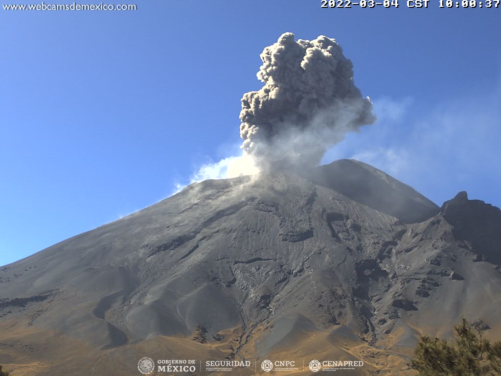
Based on the various parameters monitored and the information obtained during the last overflight, it is considered likely that ash emissions will continue to occur. Some explosions could be recorded that do not exceed in intensity those already observed. These scenarios are considered in the yellow level of phase 2 of the volcanic alert traffic light.
CENAPRED urges NOT TO APPROACH the volcano and especially the crater, due to the danger of falling ballistic fragments and, in case of heavy rains, to stay away from the bottom of the ravines due to the danger of mudslides and of debris.
The Popocatépetl volcanic alert traffic light is in YELLOW PHASE 2.
Source et photo : Cenapred .