February 20 , 2022.
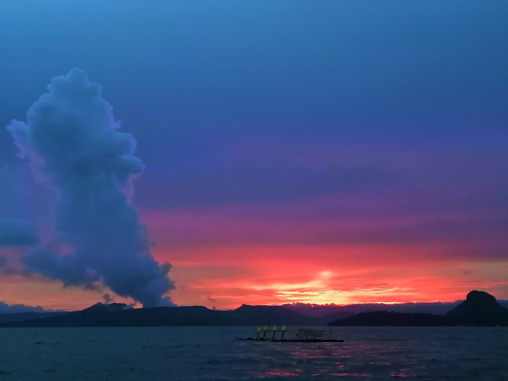
Philippines , Taal :
TAAL VOLCANO BULLETIN 20 February 2022 8:00 AM
In the past 24-hour period, the Taal Volcano Network recorded one hundred sixty-nine (169) volcanic tremor events having durations of two (2) to sixteen (16) minutes. Activity at the Main Crater was dominated by upwelling of hot volcanic fluids in its lake which generated plumes 600 meters tall that drifted southwest. Sulfur dioxide (SO2) emission averaged 6,366 tonnes/day on 18 February 2022. Based on ground deformation parameters from electronic tilt, continuous GPS and InSAR monitoring, Taal Volcano Island and the Taal region has begun deflating in October 2021.
Alert Level 2 (Increased Unrest) prevails over Taal Volcano. DOST-PHIVOLCS reminds the public that at Alert Level 2, sudden steam- or gas-driven explosions, volcanic earthquakes, minor ashfall, and lethal accumulations or expulsions of volcanic gas can occur and threaten areas within and around TVI. DOST-PHIVOLCS strongly recommends that entry into Taal Volcano Island, Taal’s Permanent Danger Zone or PDZ must be strictly prohibited, especially the vicinities of the Main Crater and the Daang Kastila fissure, and extended stays on Taal Lake.
Source : Phivolcs
Photo : Paleny Paleny
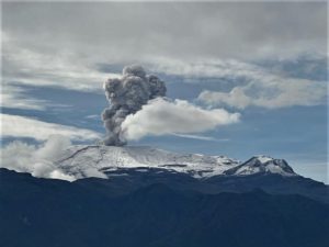
Costa Rica , Rincon de la Vieja / Turrialba / Poas :
Weekly Bulletin, February 18, 2022.
Rincon de la Vieja Volcano
latitude: 10.83°N;
Longitude: 85.324°W;
Altitude: 1895m
Current activity level: 3 (volcanic eruption)
Potentially associated dangers: Lahars, gas, phreatic and phreato-magmatic eruptions, proximal ballistic projections, acid rain, ashes.

The last phreatic eruption was recorded on February 2. This week, there has been a decrease in seismic activity, the virtual absence of LP-type, « tornillos »-type and VT-type events. The tremor is stable, of low amplitude with 2 dominant frequencies. Geodetic monitoring shows a slight extension of the base of the volcanic edifice in the period of the last 3 months, and a little inflation between December and January.
Turrialba Volcano
latitude: 10.025°N;
Longitude: 83.767°W;
Altitude: 3340m
Current activity level: 2 (active volcano)
Potentially associated hazards: gas, ash emission, proximal ballistic projections, acid rain.
The last phreatic eruption was recorded on February 6. Since the beginning of February, a decrease in the number of daily seismic events has been observed. Dominant event frequencies returned to pre-November values, so did the RSEM level. Over the past 3 months, geodetic monitoring shows a more marked contraction of the Turrialba-Irazú massif around the active crater of Turrialba. The SO2 concentration was kept stable during the week, a slight increase in the CO2/SO2 and H2S/SO2 ratios with 2 isolated peaks was observed. The weekly average for CO2/SO2 is 25.8 +/- 10, and for the H2S/SO2 ratio is 0.31 +/- 0.15. The SO2 flux is estimated at 267 +/- 91 t/d, a slightly higher value compared to the previous week.

On February 19, 2022 at 4:24 p.m. local time, an eruption is recorded on the Turrialba volcano, the height reached by the column is unknown due to the visibility conditions of the site.
Duration of the activity: 1 minute.
The winds blow to the southwest.
Ash falls reported: No ash fall is reported
Sulfur odor reported: No sulfur odor reported
Comments: This eruption was very small in terms of energy released (based on infrasound data).
Poas Volcano
latitude: 10.2°N;
Longitude: 84.233°W;
Altitude: 2780m
Current activity level: 2 (active volcano at rest)
Potentially associated dangers: gas, phreatic eruptions, proximal ballistic projections, acid rain, lahars.
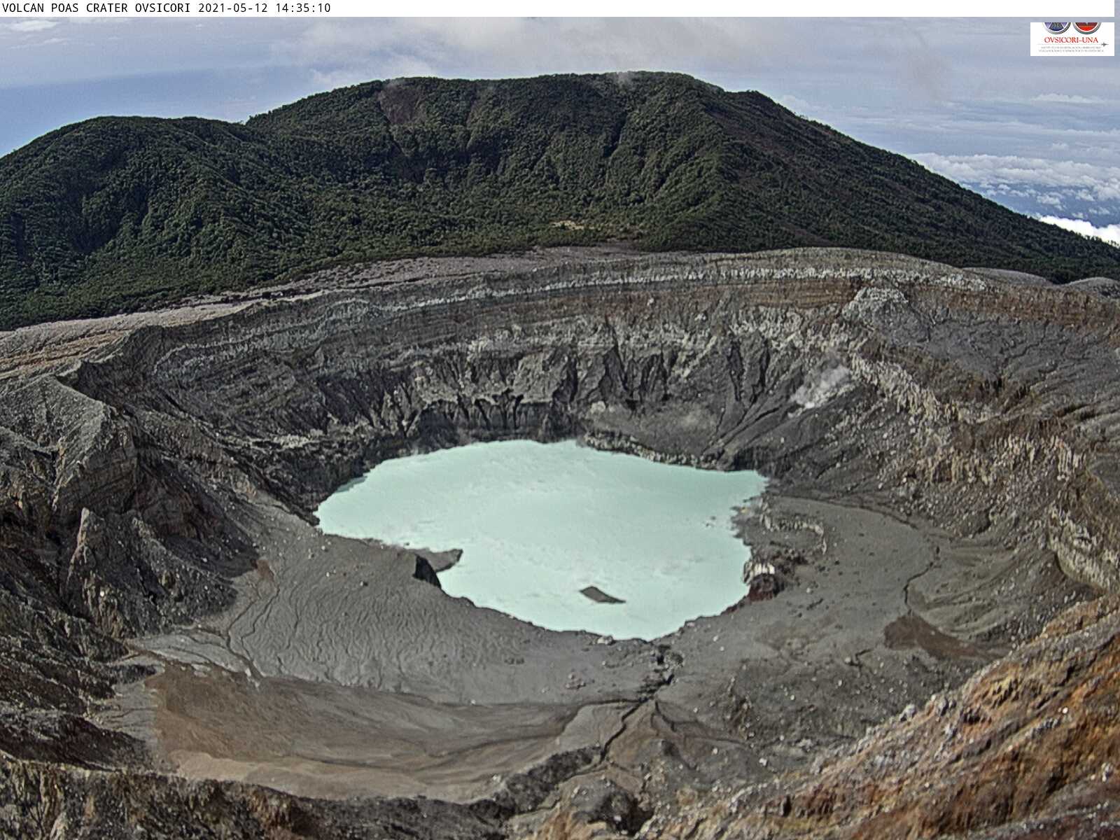
No eruption has been detected to date in 2022. Seismicity remains low with low amplitude LPS-type earthquakes and the absence of VT-type signals. The geodetic network shows a
stability of the volcanic edifice over the last 4 months. Due to low outgassing, only one SO2/CO2 measurement was made which produced a value of 0.45 and H2S/SO2 remains at values <0.01. The SO2 concentration around the crater was low during the week (<0.9 ppm SO2 at the watchtower). The flow of SO2 remains low (61 +/- 21 t/d). The level of the hyperacidic lake has increased a little.
Source : Ovsicori.
Photos : Federico Chavarría-Kopper – Ovsicori , RSN , ovsicori.
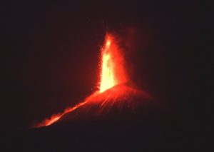
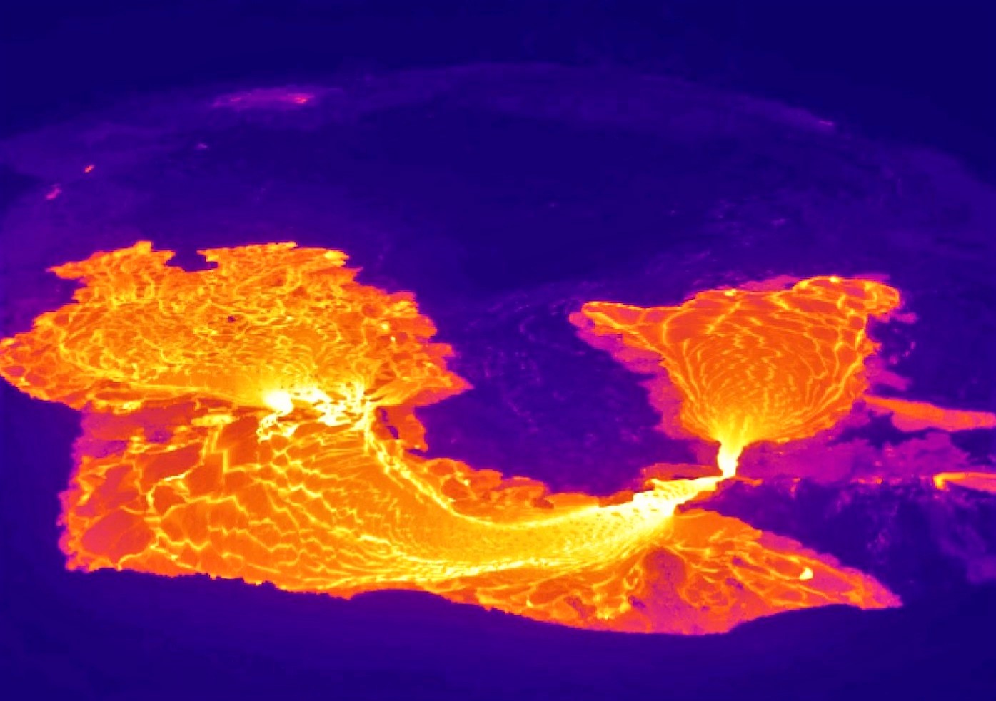
Hawaii , Kilauea :
19°25’16 » N 155°17’13 » W,
Summit Elevation 4091 ft (1247 m)
Current Volcano Alert Level: WATCH
Current Aviation Color Code: ORANGE
Activity Summary:
Effusion resumed at the summit eruption of Kīlauea Volcano beginning at approximately 6:30 pm HST yesterday, about 5 hours after inflationary tilt started and 30 minutes after an increase in volcanic tremor. All recent lava activity has been confined to the crater, and there are no indications of activity migrating elsewhere on Kīlauea.
Halemaʻumaʻu Lava Lake Observations:
Effusion of lava resumed February 18 at about 6:30 pm HST and continues this morning with the level of the western lava lake rising by approximately 10 m (33 ft). There have been no ooze outs along the margins of the lava lake over the past 24 hours. This resumption of effusive activity corresponds with an increase in summit tilt from -1.1 to +0.8 microradians that started at approximately 1:30 pm HST on February 18, and since 9:00 pm HST on February 18 the summit has been in a deflationary event with tilt dropping slightly to +0.3 microradians. The active lava lake is now approximately 89 meters (292 feet) deep relative to when lava emerged on September 29, 2021. Measurements on January 25, 2022, indicated that the total lava volume effused since the beginning of the eruption was approximately 45 million cubic meters (12.0 billion gallons) at that time.
Summit Observations:
Summit tiltmeters recorded an increase in summit tilt from -1.1 to +0.8 microradians that started at approximately 1:30 pm HST on February 18, and since 9:00 pm HST on February 18 the summit has been in a deflationary event with tilt dropping slightly to +0.3 microradians this morning. Seismic data shows that the volcanic tremor signal started to increase about 30 minutes (6:00 pm HST on February 18) before the resumption of effusive activity within the western part of the lava lake. Earthquake activity at the summit remains below background level. A sulfur dioxide (SO2) emission rate of approximately ~450 tonnes per day (t/d) was measured on February 18.
Source : HVO
Photos : USGS, C. Gansecki .
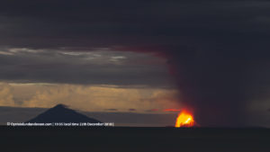
Indonesia , Semeru :
VOLCANO OBSERVATORY NOTICE FOR AVIATION – VONA
Issued : February 19 , 2022
Volcano : Semeru (263300)
Current Aviation Colour Code : ORANGE
Previous Aviation Colour Code : orange
Source : Semeru Volcano Observatory
Notice Number : 2022SMR33
Volcano Location : S 08 deg 06 min 29 sec E 112 deg 55 min 12 sec
Area : East java, Indonesia
Summit Elevation : 11763 FT (3676 M)
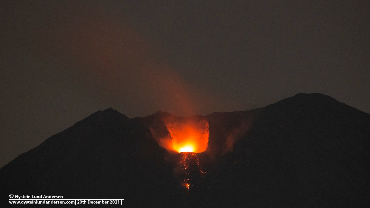
Volcanic Activity Summary :
Eruption with volcanic ash cloud at 00h01 UTC (07h01 local)
Volcanic Cloud Height :
Best estimate of ash-cloud top is around 13363 FT (4176 M) above sea level, may be higher than what can be observed clearly. Source of height data: ground observer.
Other Volcanic Cloud Information :
Ash-cloud moving to north
Remarks :
Seismic activity is characterized by eruption, avalanche and gas emission earthquakes
The volcano is clearly visible until it is covered by fog. Smoke from the crater was not observed. The weather is sunny to rainy, the wind is light in the North, South, South-West and West. The air temperature is around 21-28°C. The earthquake of the eruption was recorded, but visually the height of the eruption and the color of the ashes were not observed.
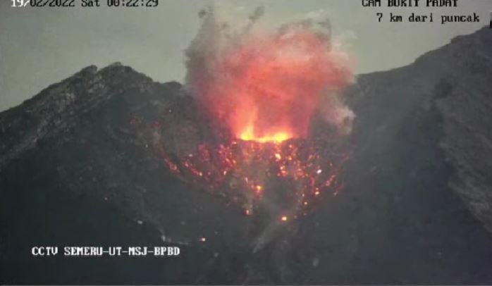
Earthquakes are related to magma, tectonic activity and lahars. It was recorded:
– 74 earthquakes of eruptions/explosions
– 8 emission earthquakes
– 8 harmonic tremors
– 1 distant tectonic earthquake
Sources : Magma Indonésie , PVMBG.
Photos : Oystein Lund Andersen , CCTV.
Iceland , Reykjanes Peninsula :
Earthquake activity has been increasing on Reykjanes peninsula as inflation continues after the end of the eruption in Fagradalsfjall mountain. New eruption can start on Reykjanes peninsula without much warning in Fargardalsfjall mountain. The current activity is now north-west of Grindavík town in a volcano named Reykjanes.
During the night an earthquake with magnitude of Mw3,2 (at 04:29 UTC) took place in Reykjanes volcano. It was felt in Grindavík town. Smaller earthquakes have continued in that area since that earthquake, but current rate of earthquakes is at the writing of this article low. That might change without warning. It is unclear what type of earthquake this is, it is possible that this is an earthquake because of ongoing inflation in Fagradalsfjall mountain and resulted stress changes that happen following that in nearby areas. At the writing of this article, everything remains quiet and there are no signs that an eruption is about to start.
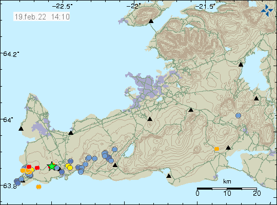
More than 310 earthquakes have been detected on the Reykjanes Peninsula this week. The largest was magnitude 2.5 just off Núpshlíðarháls on February 14 at 06:04. Activity spread across the peninsula, often in small clusters of weak earthquakes. One was just east of Sandfell, but about 35 earthquakes occurred there from February 9-10, the largest of which was measured at magnitude 2.2. About 20 earthquakes were detected offshore, about half of them just west of Reykjanestá, a magnitude 3.2 quake was about 200 km from land.
Sources : icelandgeology.net , Vedur is
Photo : IMO