February 19 , 2022.
Indonesia , Merapi :
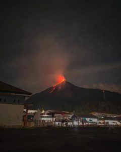
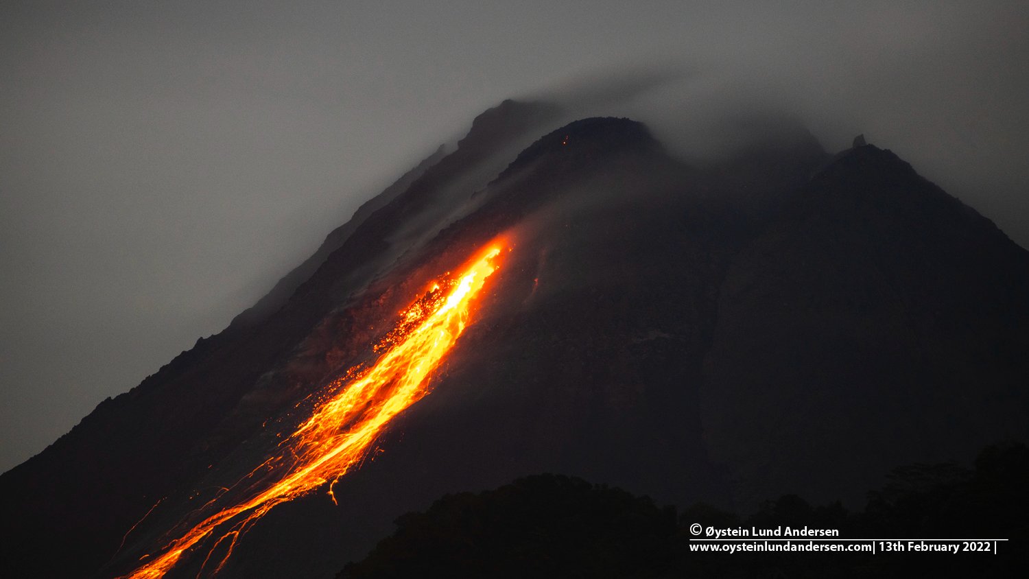
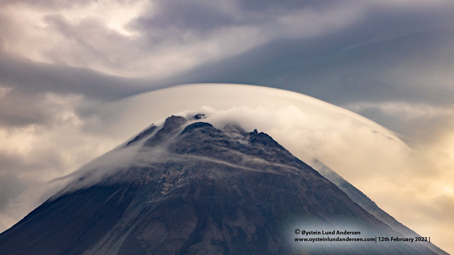
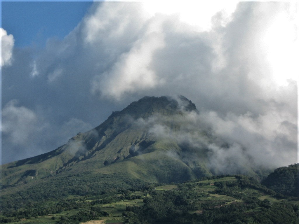
Merapi activity report from February 11 to 17, 2022.
– The weather around Mount Merapi is generally sunny in the morning and evening, while foggy in the afternoon.
– This week 3 hot clouds of hot avalanches were observed in the Southwest, upstream of the Bebeng River with a sliding distance of 2,500 to 2,800 m. Lava avalanches were observed 105 times in the southwest, descending the Bebeng River with a maximum slip distance of 2,000 m.
– Based on the morphological analysis, no significant changes were observed in either the Southwest lava dome or the central dome. The volume of the Southwest lava dome is 1,670,000 m3 and the central dome is 3,007,000 m3.
– The intensity of seismicity this week is still quite high. This is linked to magma and tectonic activity. It was recorded:
– 128 avalanche earthquakes
– 3 emission earthquakes
– 17 hybrid/multi-phase earthquakes
– 8 shallow volcanic earthquakes
– 1 distant tectonic earthquake
Mount Merapi’s deformation, which was monitored using EDM this week, showed a distance shortening rate of 0.5 cm/day.
– The rainfall intensity was 69 mm/hour for 70 minutes at Kaliurang post on February 12, 2022. No lahar or additional flow was reported in the rivers that originate on Mount Merapi.
Conclusion:
1. The volcanic activity of Mount Merapi is still quite high in the form of effusive eruption activity. The state of the activity is defined at the « SIAGA » level.
2. The current potential danger is lava avalanches and hot clouds in the South-South-West sector covering the Boyong River for a maximum of 5 km, the Bedog, Krasak, Bebeng rivers for a maximum of 7 km. The Southeast sector covers the Woro River for a maximum of 3 km and the Gendol River for a maximum of 5 km. Meanwhile, the ejection of volcanic material in the event of an explosive eruption can reach a radius of 3 km from the summit.
The public should not carry out any activity in potentially dangerous areas, anticipate disturbances due to volcanic ash from the eruption of Mount Merapi and be aware of the dangers of lahars, especially when it rains around Mount Merapi.
Sources : BPPTKG , PVMBG
Photos : Oystein Lund Andersen .
Alaska , Pavlof :
55°25’2″ N 161°53’37 » W,
Summit Elevation 8261 ft (2518 m)
Current Volcano Alert Level: WATCH
Current Aviation Color Code: ORANGE
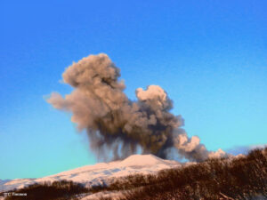
The eruption of Pavlof Volcano continues. Lava effusion continues from the vent near the summit on the northeast flank, sending a flow a short distance down the northeast flank of the volcano. Elevated surface temperatures were observed daily in satellite data over the past week. Elevated seismicity, consisting of nearly continuous tremor, was detected throughout the week.
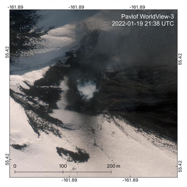
Eruption of lava at Pavlof captured in this WorldView-3 image from January 19, 2022. In this look into the active east vent, a scoria cone is building up inside the crater, partially obscured by steam. The currently active lava flow is spilling out on the southern side of a delta of older lava flows. The active channel is incandescent in this visible light image. Minor tephra deposits are also visible, darkening the snow.
Periods of lava fountaining from the vent on the volcano’s upper southeast flank have been occurring since mid-November 2021. This activity has built a small cone and sent flows down the flank that melt the snow and ice and produce variable amounts of meltwater. The meltwater typically incorporates loose debris on the flank of the volcano and forms thin (less than 2 m thick) lahars. The lahar deposits extend down the east-southeast flank for several kilometers, not quite to the base of the volcano.
Previous eruptions of Pavlof indicate that the level of unrest can change quickly and the progression to more significant eruptive activity can occur with little or no warning.
Pavlof is monitored by local seismic and infrasound sensors, satellite data, web cameras, and remote infrasound and lightning networks.
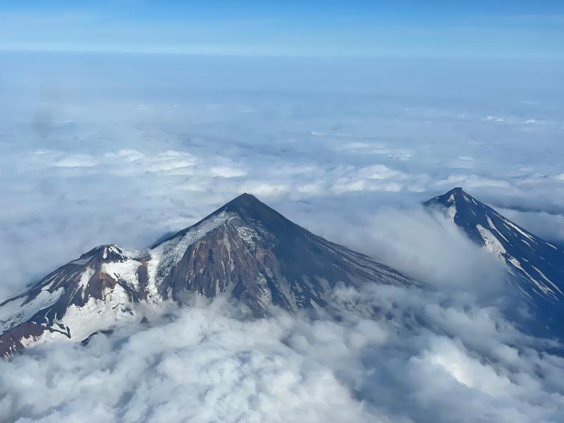
Pavlof Volcano is a snow- and ice-covered stratovolcano located on the southwestern end of the Alaska Peninsula about 592 mi (953 km) southwest of Anchorage. The volcano is about 4.4 mi (7 km) in diameter and has active vents on the north and east sides close to the summit. With over 40 historic eruptions, it is one of the most consistently active volcanoes in the Aleutian arc. Eruptive activity is generally characterized by sporadic Strombolian lava fountaining continuing for a several-month period. Ash plumes as high as 49,000 ft (15 km) above sea level have been generated by past eruptions of Pavlof, and during the March 2016 eruption, ash plumes as high as 40,000 ft (12.2 km) above sea level were generated and the ash was tracked in satellite data as distant as eastern Canada. The nearest community, King Cove, is located 30 mi (48 km) to the southwest of Pavlof.
Source : AVO.
Photos : Dietterich, Hannah , Ben David Jacob.
Ecuador , Reventador :
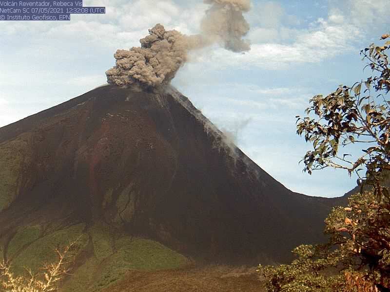
DAILY REPORT OF THE STATE OF THE REVENTADOR VOLCANO, Friday February 18, 2022.
Information Geophysical Institute – EPN.
Surface Activity Level: High, Surface Trend: No change.
Internal activity level: Moderate, Internal trend: No change.
Seismicity: From February 17, 2022, 11:00 a.m. to February 18, 2022, 11:00 a.m.:
Explosion (EXP) 13
Long Periods (LP) 42
Emission Tremors (TREMI) 9.
Harmonic tremor (TRARM): 1
Rains / Lahars:
No rain was recorded.
Emission / ash column:
During the night, several gas and ash emissions were observed, which exceeded 1000 m with a predominant direction towards the North-West. The Washington VAAC over the past 24 hours reported three ash emissions, which reached 988 m a.s.l., heading west, northwest and northeast respectively. The last one reached 1,338 m asl dispersing to the south-east.
Other Monitoring Parameters:
FIRMS records 5 thermal alerts on the Reventador in the last 24 hours
Observation:
At night, an incandescence was observed in the upper part as well as the descent of incandescent material on the southern flank, up to 300 m altitude.
Alert level: Orange.
Source : IGEPN.
Photo : IGEPN ( archive) .
La Martinique , Montagne Pelée :
Weekly report on the activity of Mount Pelée for the period from February 11 to 18, 2022.
Between January 28, 2022 at 4 p.m. (UTC) and February 4, 2022 at 4 p.m. (UTC), the OVSM recorded at least 1 volcano-tectonic earthquakes of magnitude less than or equal to 0.2. These earthquakes were located inside the volcanic edifice between 0.6 and 1.0 km deep below the surface. This superficial volcano-tectonic seismicity is associated with the formation of micro-fractures in the volcanic edifice.
During this period, the OVSM also recorded 1 hybrid type earthquake. This signal containing low frequencies is associated with the presence of fluids (gas, hydrothermal waters) in the volcanic edifice. None of these earthquakes were felt by the population.
The zone of degassing at sea at shallow depth between St Pierre and le Prêcheur is still observed. The IGP took fluid samples in order to understand the origin of this degassing and to assess its possible relationship with the Mount Pelée hydrothermal system.
An extension of two areas of degraded vegetation located between Morne Plume and the Rivière Chaude was observed during a helicopter flight carried out on February 9, with the support of Dragon 972, and confirmed by analysis of satellite images.
The alert level remains YELLOW: vigilance.
Source : Direction de l’OVSM IPGP.
Photo : Jmp48 / Wikipedia
Hawaii , Mauna Loa :
19°28’30 » N 155°36’29 » W,
Summit Elevation 13681 ft (4170 m)
Current Volcano Alert Level: ADVISORY
Current Aviation Color Code: YELLOW
Activity Summary:
Mauna Loa Volcano is not erupting. There have been approximately 63 earthquakes in the summit region of Mauna Loa over the past week. This is a return to background levels following a small increase in activity over week of February 5. Other Mauna Loa monitoring data streams—ground deformation, gas concentrations, visual appearance in webcams—show no significant changes.

Observations:
The summit region of Mauna Loa (including the east flank, west flank, and upper parts of the northeast and southwest rift zones) has seen approximately 63 earthquakes over the past week. However, the daily rate of seismicity has continued to decrease since its peak on February 5.
Global Positioning System (GPS) measurements show very low rates of deformation in the summit region continuing through the past week.
Gas concentrations and fumarole temperatures at the summit and at Sulphur Cone on the Southwest Rift Zone remain stable.
Webcam views have shown no changes to the volcanic landscape on Mauna Loa over the past week.
Source et photo : HVO