February 17 , 2022.
Italy , Vulcano :
WEEKLY BULLETIN from February 07, 2022 to February 13, 2022. (issue date February 15, 2022)
ACTIVITY STATUS SUMMARY
In the light of the surveillance data, it is highlighted:
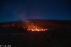
1) Temperature of the crater fumaroles: The temperatures recorded on the edge of the crater show a strong variability linked to atmospheric phenomena, while on the internal side they continue to remain stable.
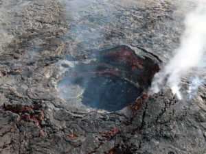
2) CO2 flux in the crater area: The CO2 flux in the crater area remains at high values.
3) SO2 flux in the crater area: SO2 flux at a high and decreasing level
4) Geochemistry of fumarolic gases: No update is available.
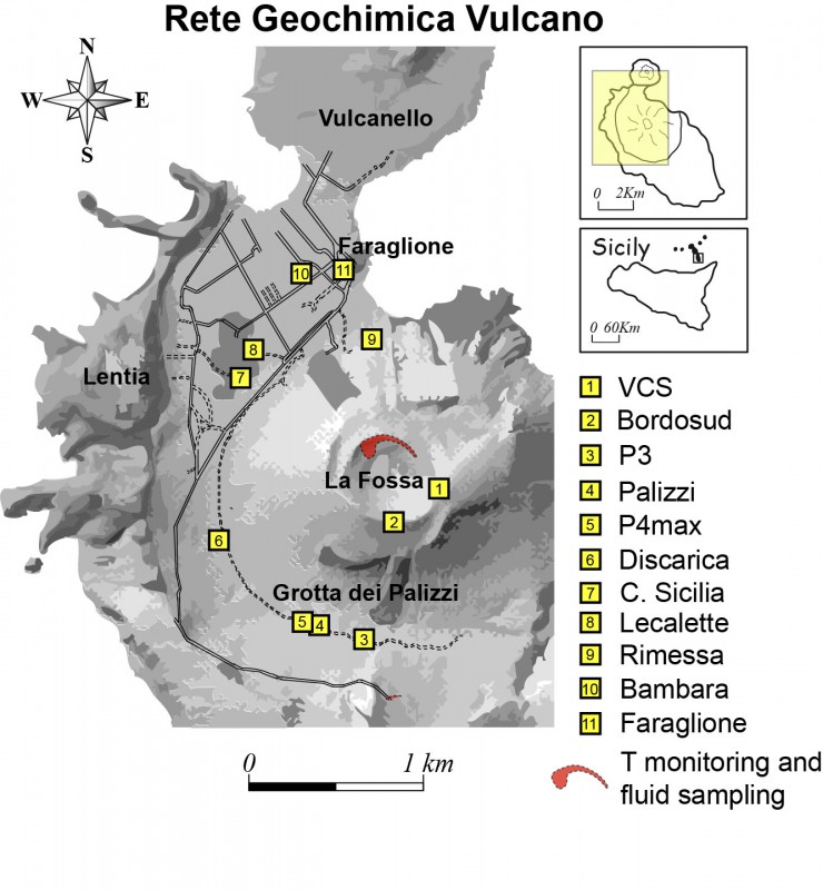
5) CO2 fluxes at the base of the La Fossa cone and in the Vulcano Porto area: The CO2 fluxes at the base of the crater remain at medium-high values with a tendency to decrease with the exception of the Faraglione site , where values close to the background level are recorded.
6) Geochemistry of thermal aquifers: The physico-chemical parameters recorded in the Camping Sicilia and Bambara wells remain stable at high values while showing a very slight decrease.
7) Local seismicity: low occurrence rate of local events
8) Regional seismicity: No earthquake with Ml >= 1.0 was located in the area of the island of Vulcano.
9) Deformations – GNSS: The GNSS surveillance network does not present substantial variations
10) Deformations – Inclinometry: Data from the Vulcano tilt network show a modest deflation trend.
11) Other observations: Gravimetry: During the period considered in the VPORT station, various cyclical variations were recorded.
GB-RAR: The GB-RAR monitoring results referring to the period December 14, 2021 – February 14, 2022, show a general stability of the area, with deformations along the LOS of less than 1 mm.
Mobile GNSS: Mobile GNSS stations do not appear to show significant changes over the reporting period.
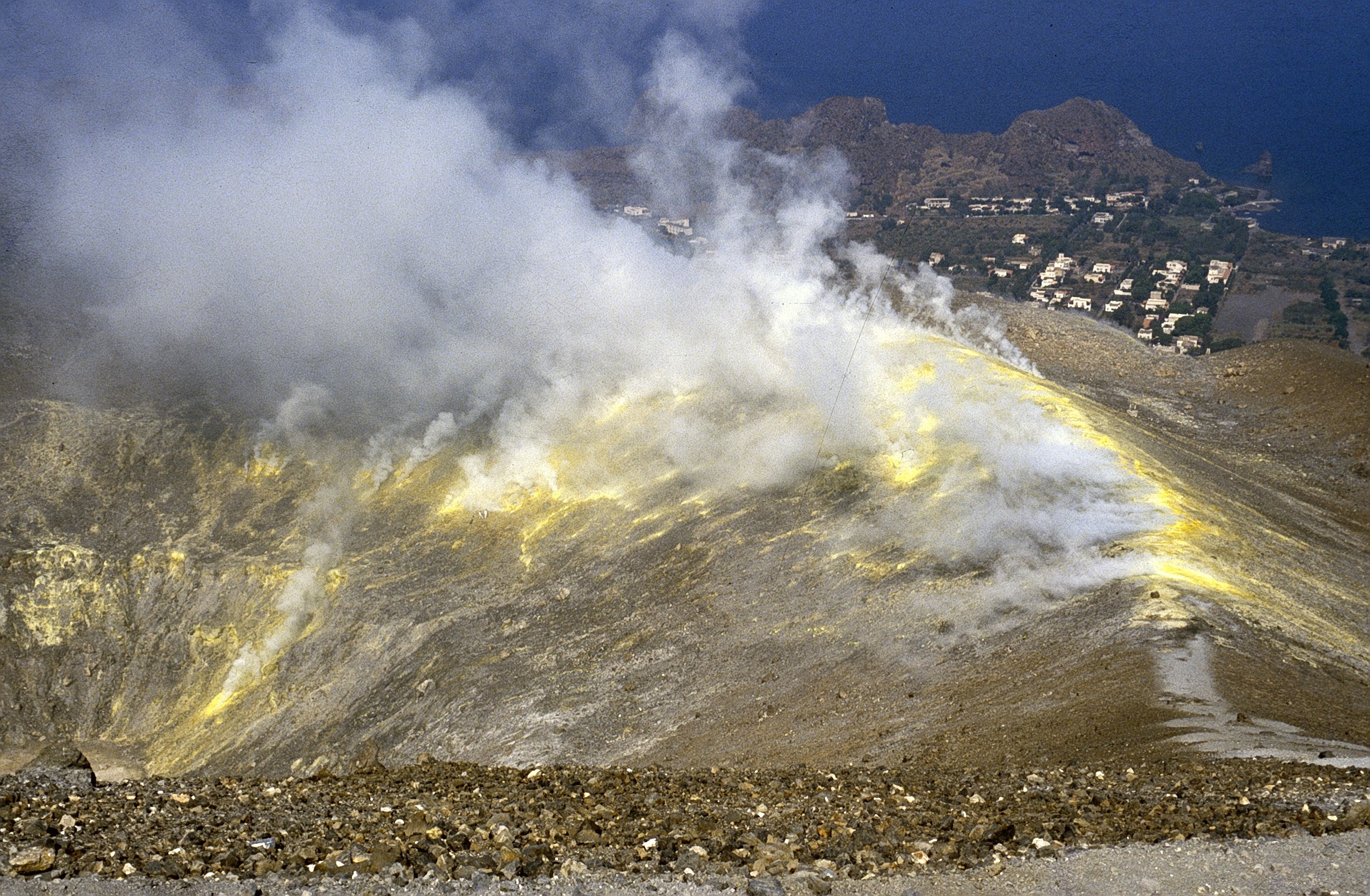
CRATER SMOKE TEMPERATURE.
In recent weeks, the fumaroles of the summit rim and the internal slope have shown a thermal trend strongly disturbed by atmospheric phenomena. The updated data confirms the continuation of the thermal anomaly, extended outside the sector affected by the fumaroles of other temperatures. The temperatures of the profile of this station remain high, despite the infiltration of quantities of rain clearly higher than the average for the period and the relatively harsh atmospheric conditions (t air 15°C). The temperature for the internal face is confirmed stable at 110°C. For technical reasons, it is impossible to validate the growth data presented last week by an edge fumarole (T2).
CO2 FLOW IN THE CRATER AREA
The CO2 flux values from the ground in the summit zone (daily average) are on average values higher than 11398 g/m2/day, always on an order of magnitude higher than the averages recorded over the last 10 years. The average value of the CO2 flux (monthly average) in February 2022 is 13354 g/m2/day. A stabilization of degassing at high values is therefore observed on a monthly scale, with a slight decrease compared to the previous month.
Source : INGV.
Photos : INGV , Boris Behncke
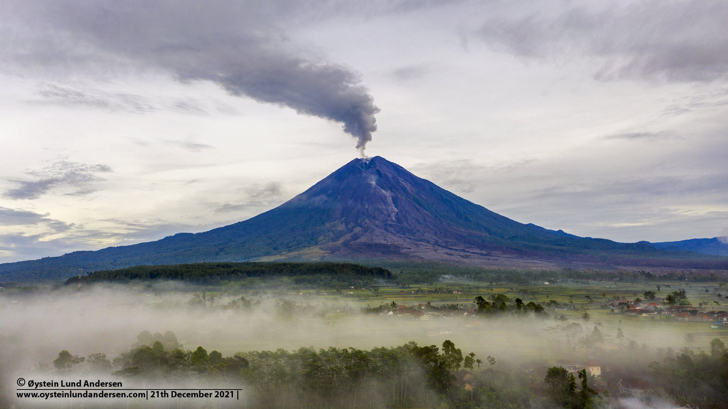
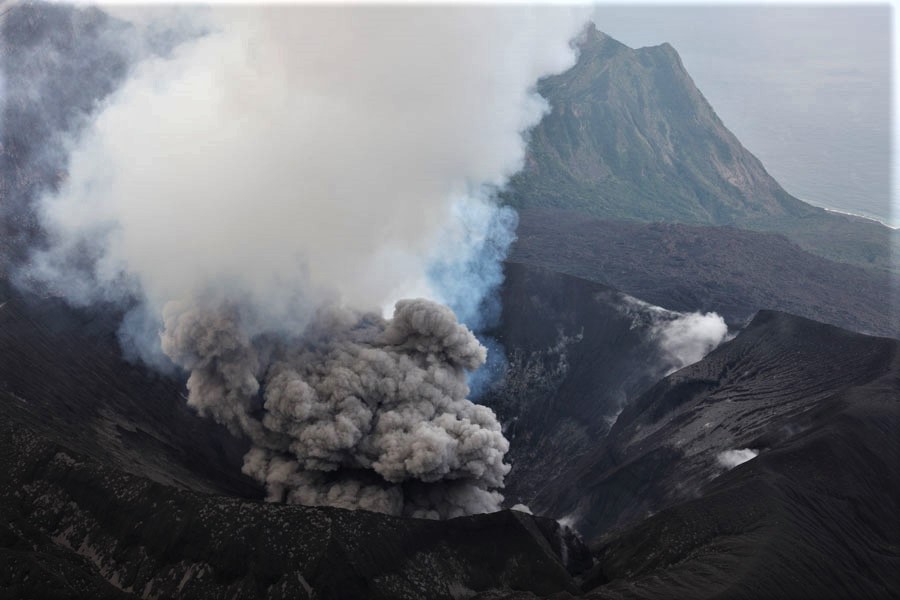
Indonesia , Semeru :
The volcano was clearly visible until it was covered by fog. Smoke from the crater was not observed. The weather is sunny to rainy, the wind is weak in the North-East, in the East, in the South and in the West. The air temperature is around 21-30°C. The earthquake of the eruption was recorded, but visually the height of the eruption and the color of the ashes were not observed.
Earthquakes are related to magma, tectonic activity and lahars. It was recorded:
– 71 earthquakes of eruptions/explosions
– 12 emission earthquakes
– 1 harmonic tremor
– 3 distant tectonic earthquakes
VOLCANO OBSERVATORY NOTICE FOR AVIATION – VONA
Issued : February 17 , 2022
Volcano : Semeru (263300)
Current Aviation Colour Code : ORANGE
Previous Aviation Colour Code : orange
Source : Semeru Volcano Observatory
Notice Number : 2022SMR30
Volcano Location : S 08 deg 06 min 29 sec E 112 deg 55 min 12 sec
Area : East java, Indonesia
Summit Elevation : 11763 FT (3676 M)
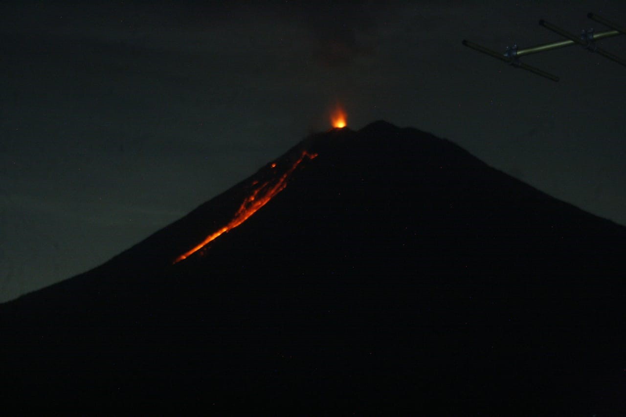
Volcanic Activity Summary :
Eruption with volcanic ash cloud at 00h09 UTC (07h09 local). Eruption and ash emission is continuing.
Volcanic Cloud Height :
Best estimate of ash-cloud top is around 14003 FT (4376 M) above sea level, may be higher than what can be observed clearly. Source of height data: ground observer.
Other Volcanic Cloud Information :
Ash-cloud moving to west.
Sources : PVMBG , Magma Indonésie.
Photos : Oystein Lund Andersen. pvmbg.
Russia / Kuril Islands , Ebeko :
The Ministry of Emergency Situations declares emissions at a height of 1.8 km.
Ash emissions were again recorded on the Ebeko volcano. This was reported to the Ministry of Emergency Situations of Russia in the Sakhalin region.
“This afternoon, the Crisis Management Center received information that 2 emissions occurred on the Ebeko volcano at an altitude of 1.8 km. The plumes spread in a southwesterly direction,” the department said.
According to EDDS, no ash fall was observed in Severo-Kurilsk. The smell of hydrogen sulphide was not felt. There is no threat to the livelihoods of the population.
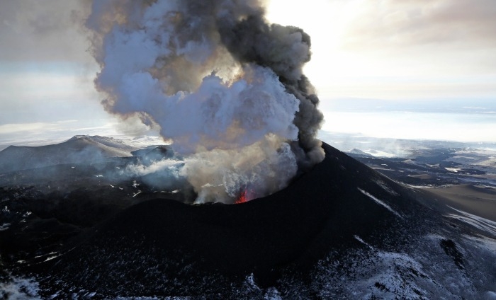
The flat-topped summit of the central cone of Ebeko volcano, one of the most active in the Kuril Islands, occupies the northern end of Paramushir Island. Three summit craters located along a SSW-NNE line form Ebeko volcano proper, at the northern end of a complex of five volcanic cones. Blocky lava flows extend west from Ebeko and SE from the neighboring Nezametnyi cone. The eastern part of the southern crater contains strong solfataras and a large boiling spring. The central crater is filled by a lake about 20 m deep whose shores are lined with steaming solfataras; the northern crater lies across a narrow, low barrier from the central crater and contains a small, cold crescentic lake. Historical activity, recorded since the late-18th century, has been restricted to small-to-moderate explosive eruptions from the summit craters. Intense fumarolic activity occurs in the summit craters, on the outer flanks of the cone, and in lateral explosion craters.
Sources : astv.ru , GVP
Photo : Yuri Demyanchuk
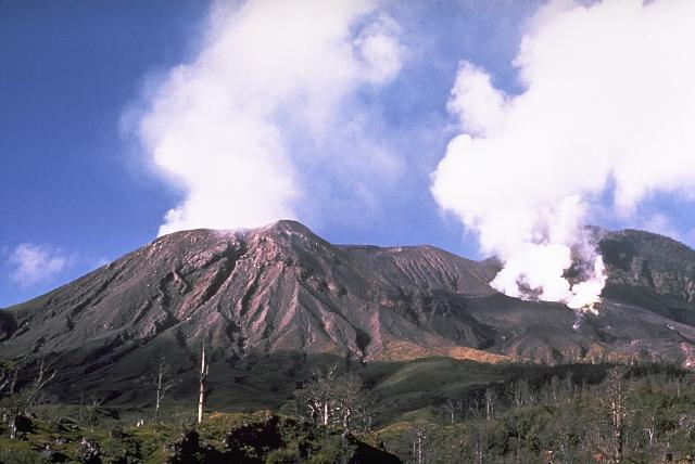
Japan , Suwanosejima :
JMA reported that five explosions were recorded at Suwanosejima’s Ontake Crater during 7-14 February. The explosions produced ash plumes that rose as high as 2 km above the crater rim and ejected large blocks 300-400 m from the crater. Ashfall was reported in Toshima village (3.5 km SSW) during 11-14 February. The Alert Level remained at 3 and the public was warned to stay 2 km away from the crater.
The 8-km-long, spindle-shaped island of Suwanosejima in the northern Ryukyu Islands consists of an andesitic stratovolcano with two historically active summit craters. The summit is truncated by a large breached crater extending to the sea on the east flank that was formed by edifice collapse. Suwanosejima, one of Japan’s most frequently active volcanoes, was in a state of intermittent strombolian activity from Otake, the NE summit crater, that began in 1949 and lasted until 1996, after which periods of inactivity lengthened. The largest historical eruption took place in 1813-14, when thick scoria deposits blanketed residential areas, and the SW crater produced two lava flows that reached the western coast. At the end of the eruption the summit of Otake collapsed forming a large debris avalanche and creating the horseshoe-shaped Sakuchi caldera, which extends to the eastern coast. The island remained uninhabited for about 70 years after the 1813-1814 eruption. Lava flows reached the eastern coast of the island in 1884. Only about 50 people live on the island.
Sources : GVP , Agence météorologique japonaise (JMA)
Photo : Photovolcanica / Dr Richard Roscoe .
Papua – New Guinea , Langila :
The Darwin VAAC reported that on 9 February ash plumes from Langila were visible in satellite images rising 4.3 km (14,000 ft) a.s.l. and drifting SW.
Langila, one of the most active volcanoes of New Britain, consists of a group of four small overlapping composite basaltic-andesitic cones on the lower E flank of the extinct Talawe volcano in the Cape Gloucester area of NW New Britain. A rectangular, 2.5-km-long crater is breached widely to the SE; Langila was constructed NE of the breached crater of Talawe. An extensive lava field reaches the coast on the N and NE sides of Langila. Frequent mild-to-moderate explosive eruptions, sometimes accompanied by lava flows, have been recorded since the 19th century from three active craters at the summit. The youngest and smallest crater (no. 3 crater) was formed in 1960 and has a diameter of 150 m.
Source : Darwin VAAC , GVP.
Photo : Wally Johnson