January 24 , 2022.
Alaska , Semisopochnoi :
51°55’44 » N 179°35’52 » E,
Summit Elevation 2625 ft (800 m)
Current Volcano Alert Level: WATCH
Current Aviation Color Code: ORANGE
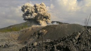
Low-level eruptive activity continues at Semisopochnoi from the North Cerberus cone. Seismicity remains elevated. Steam and low-level ash emissions were observed in web camera images, and elevated surface temperatures were observed in satellite views. Local seismic and infrasound sensors have recorded numerous small explosions over the past day.
Small eruptions producing minor ash deposits within the vicinity of the active north crater of Mount Cerberus and ash clouds usually under 10,000 ft above sea level have characterized the recent activity. Small explosions and associated ash emissions may continue and could be difficult to detect, especially when thick cloud cover obscures the volcano.
Semisopochnoi is monitored by local seismic and infrasound sensors, satellite data, web cameras, and remote infrasound and lightning networks.
Source : AVO.
Photo : Rojek, Nora / R/V Tiglax .
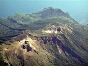
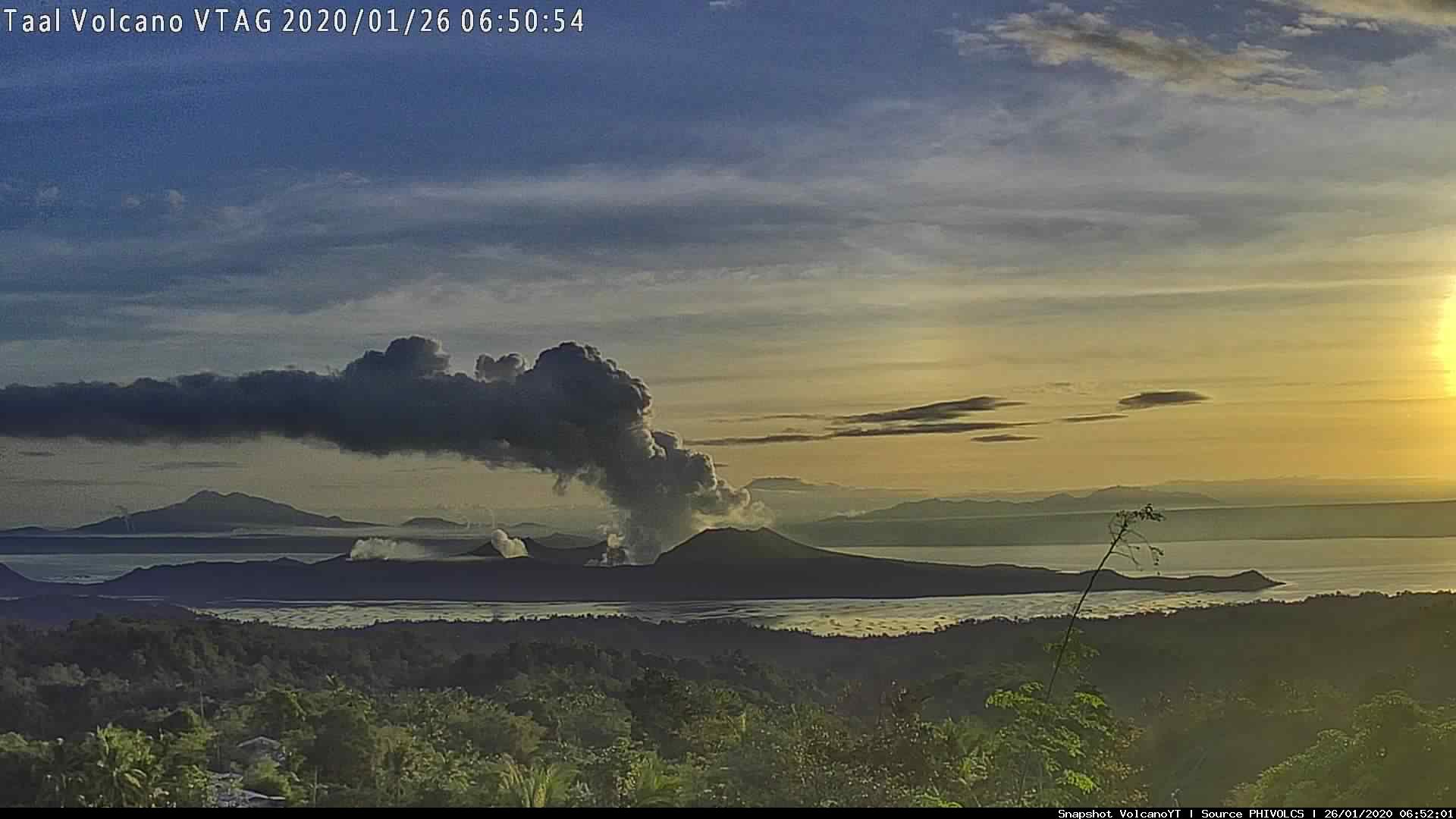
Philippines , Taal :
TAAL VOLCANO BULLETIN 24 January 2022 8:00 AM
In the past 24-hour period, the Taal Volcano Network did not detect any volcanic earthquake, but low-level background tremor has persisted since 7 July 2021. Activity at the Main Crater was dominated by upwelling of hot volcanic fluids in its lake which generated plumes 1,800 meters tall that drifted southwest. Sulfur dioxide (SO2) emission averaged 11,228 tonnes/day on 23 January 2022. Based on ground deformation parameters from electronic tilt, continuous GPS and InSAR monitoring, Taal Volcano Island and the Taal region has begun deflating in October 2021.
Alert Level 2 (Increased Unrest) prevails over Taal Volcano. DOST-PHIVOLCS reminds the public that at Alert Level 2, sudden steam- or gas-driven explosions, volcanic earthquakes, minor ashfall, and lethal accumulations or expulsions of volcanic gas can occur and threaten areas within and around TVI. DOST-PHIVOLCS strongly recommends that entry into Taal Volcano Island, Taal’s Permanent Danger Zone or PDZ must be strictly prohibited, especially the vicinities of the Main Crater and the Daang Kastila fissure, and extended stays on Taal Lake. Local government officials are advised to continuously assess and strengthen the preparedness of previously evacuated barangays around Taal Lake in case of renewed unrest. Civil aviation authorities must advise pilots to avoid flying close to the volcano as airborne ash and ballistic fragments from sudden explosions and wind-remobilized ash may pose hazards to aircraft. DOST-PHIVOLCS is closely monitoring Taal Volcano’s activity and any new significant development will be immediately communicated to all stakeholders.
Source : Phivolcs
Photo : VTAG.
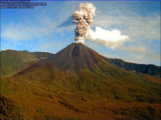
Ecuador , Reventador / Wolf :
DAILY REPORT OF THE STATE OF THE REVENTADOR VOLCANO, Sunday January 23, 2022.
Information Geophysical Institute – EPN.
Surface Activity Level: High, Surface Trend: No change.
Internal activity level: Moderate, Internal trend: No change.
Seismicity: From January 22, 2022, 11:00 a.m. to January 23, 2022, 11:00 a.m.:
Explosion (EXP) 18
Long Periods (LP) 25
Emission Tremors (TREMI) 8.
Rains / Lahars:
Light rains were recorded, without causing lahars.
Emission / ash column:
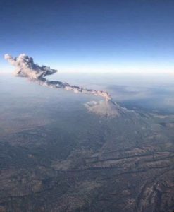
Yesterday afternoon, an emission of gas and ash was recorded which exceeded 1000 m in altitude, heading west. The Washington VAAC reported two ash emissions at a height of 988 meters above sea level in a southwesterly direction.
Other Monitoring Parameters:
MIROVA recorded 1 moderate thermal alert on the Reventador in the last 24 hours.
Alert level: Orange.
——————————————————————————————
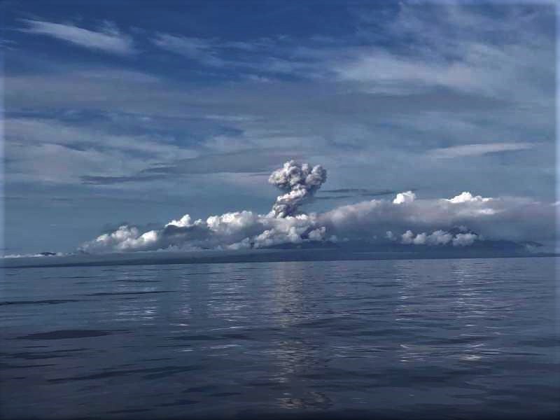
DAILY REPORT OF THE STATE OF WOLF VOLCANO. January 23, 2022.
Surface Activity Level: High, Surface Trend: Unchanged
Internal activity level: High, Internal trend: No change.
Seismicity: From January 22, 2022, 11:00 a.m. to January 23, 2022, 11:00 a.m.:
Due to problems in the monitoring network, there is no seismic information.

Rains / Lahars: There are no reports of rain.
Emission / ash column:
The Washington VAAC reported several ash emissions reaching up to 1170 m a.s.l., their direction was north and northwest.
Other Monitoring Parameters:
FIRMS registers 68 thermal alerts and MIROVA registers 2 high thermal alerts (546 and 140 MW) in the last 24 hours.
Source : IGEPN.
Photos : IGEPN ( archive ) , Parque Nacional Galápagos.
Guatemala , Santiaguito :
ACTIVITY:
The Santiaguito volcano maintains a constant, abundant and sustained white outgassing from 100 to 500 meters above the dome of the Caliente dome, as well as weak to moderate explosions up to a height of 3,200 meters above the level of the sea (10,499 feet) which disperse to the west and southwest over a distance of 10 to 15 kilometers. There are possibilities of slight fall of fine ash particles in the villages of Loma Linda, San Marcos Palajunoj and others in this area.
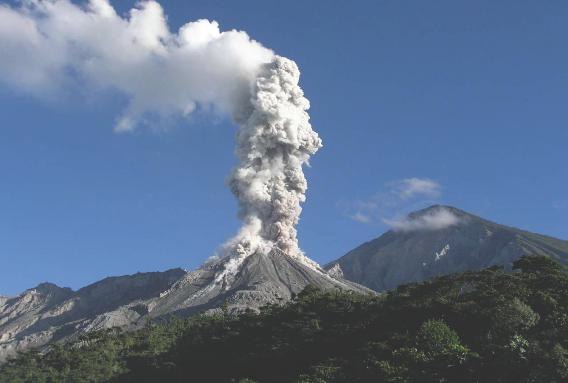
Weak, moderate and strong avalanches are recorded. Incandescence continues to be noted over the Caliente dome as well as instability due to lava flow. The Santiaguito volcano is in a high period of lava extrusion, this causes constant boulder avalanches around the volcanic building, so strong avalanches and even pyroclastic flows can be generated, so do not stay near or in the riverbeds near the slopes of the volcano. (Information in BESAN bulletin 156-2021).
Source : Insivumeh .
Photo : la hora
Dominique , Boiling Lake :
St. Augustine, Trinidad & Tobago – Tuesday January 11th, 2022
Observations of water levels and activity at the Boiling Lake reported by local tour guides, to Dominica’s Office of Disaster Management (ODM) over the period 9 – 31 December, indicate that water levels at the Boiling Lake have gradually returned to conditions that closer reflect it normal state of activity.
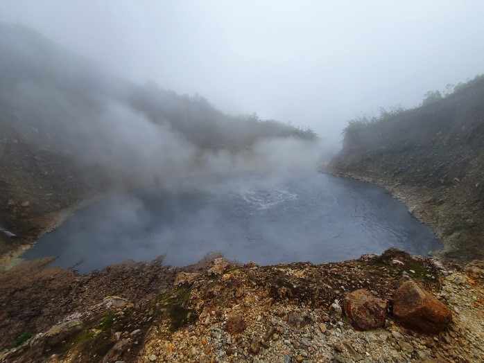
The observed changes in water levels and activity at the Boiling Lake have occurred in the past and are not necessarily related to increased volcanic activity in the area. Historically, these periods of instability can last for weeks to months before normal activity is fully re-established. During these episodes harmful gases such as Carbon Dioxide, can be released and small steam explosions may also occur. People should, therefore, exercise caution if visiting the Boiling Lake until the activity fully resumes to its normal state.
The UWI-SRC and Dominica’s Office of Disaster Management (ODM) with support from the Forestry, Wildlife & Parks Division, are continuing to monitor the situation and will provide updates as necessary.
Saint Vincent , Soufrière Saint Vincent :
Seismic activity at La Soufrière, St Vincent continues to be at a low level since the tremor associated with the explosion and ash venting on 22 April, 2021. No lahar signals have been recorded during the reporting period.

Current activity is consistent with a period of unrest after an eruption. This can continue for weeks to months. While volcanic activity has been on a decline, there is the continued presence of near surface hot spots, daily seismic activity and persistent degassing
There is a small, but not insignificant, possibility that magmatic activity might restart, should there be an influx of new magma from depth.
The volcano is at alert level YELLOW.
Source : uwiseismic.com
Photos : UWI , Nemo .