April 04, 2019.
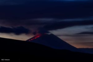
Colombia , Chiles / Cerro Negro :
Weekly activity bulletin Chiles and Cerro Negro volcanoes
The level of activity of volcanoes continues at: YELLOW LEVEL ■ (III): CHANGES IN THE BEHAVIOR OF VOLCANIC ACTIVITY.
Following the activity of the CHILE volcanoes and CERRO NEGRO, the COLOMBIAN GEOLOGICAL SERVICE (SGC) reports that:
During the last week evaluated between March 26 and April 1, 2019, the number and seismic energy released decreased significantly from 7839 to 2,220 volcano-tectonic earthquakes, which are associated with fractures of rocks in the volcanic building. This seismicity was concentrated towards the south-west and south of the Chiles volcano, at depths between 2 and 6 km below the summit (4700 m altitude) and with a magnitude lower than 2.3 on the scale of Richter. No events were reported as felt.
Other geophysical and geochemical parameters of volcanic monitoring did not show significant variations.
The COLOMBIAN GEOLOGICAL SERVICE is attentive to the evolution of the volcanic phenomenon and will continue to inform in a timely manner of the observed changes.
Source : OVPF.
Photo : SGC
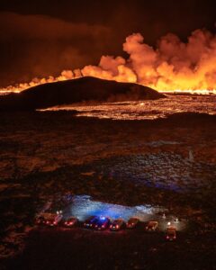
La Réunion , Piton de la Fournaise :
Seismicity:
In March 2019, the OVPF recorded at the level of the Piton de la Fournaise massif in total: 328 superficial volcano-tectonic earthquakes (0 to 2 km deep) under the summit craters; 9 deep earthquakes (> 2 km deep); 134 collapses (in the Crater Dolomieu and the ramparts of Enclos Fouqué).
The end of the eruption of February 18 – March 10, 2019 was marked by a sustained seismicity located above the crater Dolomieu above sea level (0 to 2 km deep); 162 superficial volcano-tectonic earthquakes were recorded between March 7 and 10, 2019.
Since the end of the eruption, a superficial seismicity is still recorded; on average about ten earthquakes per day. In parallel, 5 deep earthquakes have been recorded since the end of the eruption. This seismicity shows that the superficial magmatic system is always pressurized by a deep recharge and that the roof of the magma reservoir is weakened.
Deformation:
The end of the eruption of February 18 – March 10 was accompanied by a marked deflation (March 7 to 10), linked to a rapid emptying of the magma reservoir, thus explaining the high surface flow recorded at the end of eruption. (20-25 m3 / sec) (see section B). Following the end of the eruption, inflation (swelling) of the building resumed immediately (1.5-2 cm between March 10 and 31), indicating a pressurization of the superficial reservoir.
Balance sheet:
The resumption of inflation of the building, accompanied by seismicity, following the end of the eruption of February 18 – March 10, 2019, is the witness of a pressurization of the superficial magmatic reservoir. This pressurization is related to a magmatic transfer of the deep zones towards this reservoir as evidenced by the CO2 concentrations in the far-field soil which are maintained at intermediate values.
Source : OVPF
Photo : OVPF/IPGP
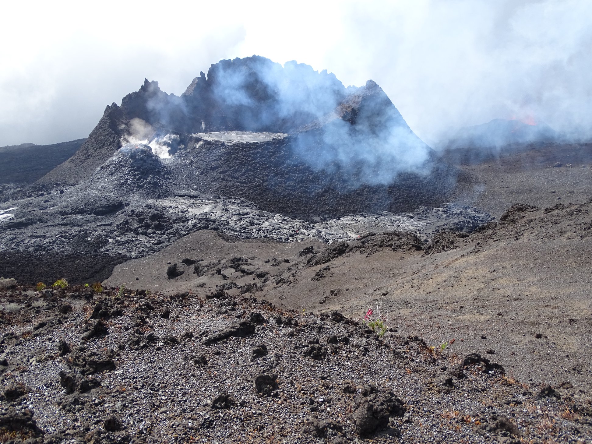
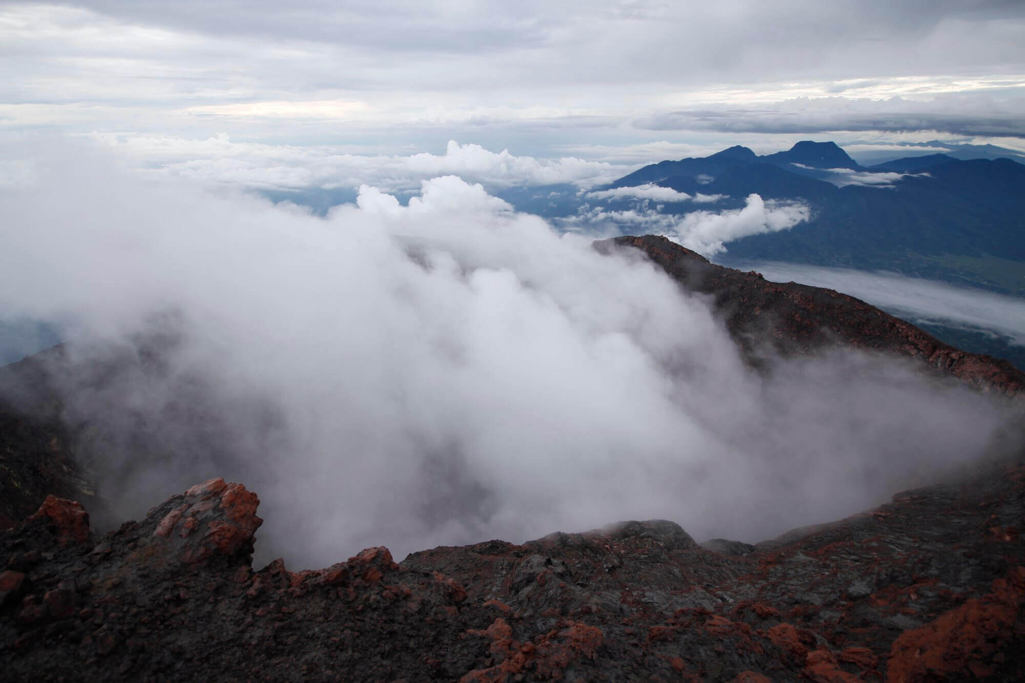
Ecuador , Sangay :
New eruptive phase
Summary:
The Sangay volcano, in the Morona Santiago province, showed the establishment of a new eruptive phase on March 26, 2019, observed in a Washington VAAC ash emission alert and a GOES 16 satellite image. explosion has also been recorded in the SAGA multi-parameter station (W side of the volcano). This represents a potential threat to people who frequent the areas surrounding the volcano, especially those who decide to climb to the top of it .

The last eruption of the volcano took place in 2018, where an eruptive phase took place over a period of 4 months, from August 8 to December 7. This eruption was characterized by the emission of ash columns up to 2500 m above the crater level, which caused a small ashfall in Guayaquil on 18 September. In addition, and limited to the vicinity of the volcano crater, lava flows and pyroclastic flows had been observed and descended to the east and south-east flanks (Special Report 2018 No. 3).
Visual observations and surface activity:
On Tuesday, March 26, 2019 at 06:00 local time (TL) (11:00 UTC), the VAAC Washington reported an ash cloud emission alert whose source is the Sangay volcano, the estimated height of this column was <1. km, with a preferential direction towards the South-West (Fig. 1 – a). Thermal warnings were not observed until the release of this report. At 6:15 am (11:15 am local time), thanks to an image from the GOES16 satellite, the program was broadcast whose preferential direction was South-West (Fig. 1 – b).
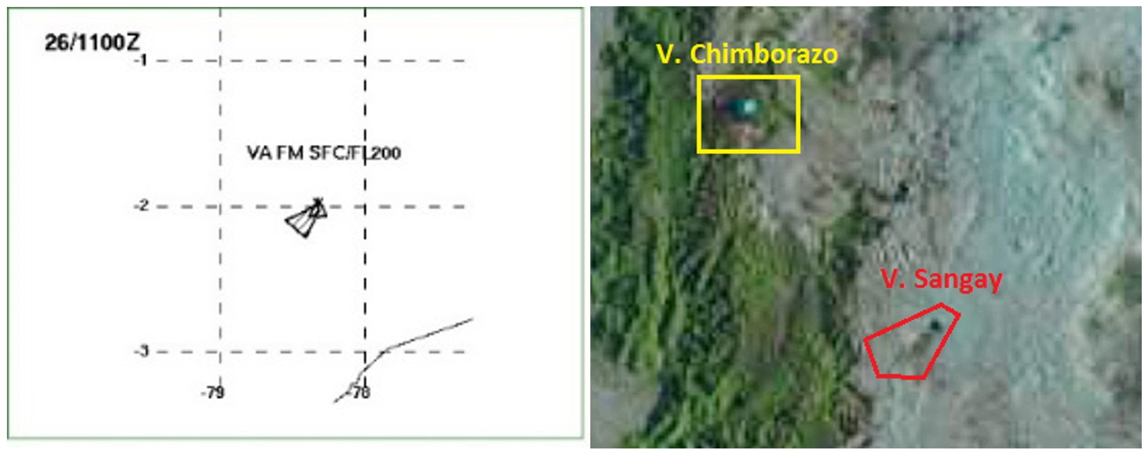
Figure 1. Left (a): maximum height of the ash column indicated by the Washington VAAC (https://www.ssd.noaa.gov/VAAC/messages.html) (March 26, 2019) at 06:00. local (TL). Right (b): Image of the GOES16 satellite for the Sangay Volcano area, note the ash emission in the red polygon and, for reference, the Chimborazo volcano in the yellow zone.
On the simulation of the dispersion and the fall of the ash carried out by the EPN IG with the model Ash3D of the USGS, corresponding to the current day with a hypothetical height of 1,2 km, one can note that the preferential direction of the deposit of ash is in the Southwest, suggesting the possibility of a small fall of ash in communities such as: Asomana, Parbarumi, Punguloma, Huascayacu, Guascayacu, Shisha, Colay, Atillo Chico, Atillo Grande, Puca Totoras, Punupamba , Guallaban, Peña Blanca and Ozogoche Bajo. As this is a relatively low emission, it is expected that it will not affect other populations further away from the volcano. The largest falls will be confined to the periphery of the volcano and other uninhabited areas (Fig. 2).
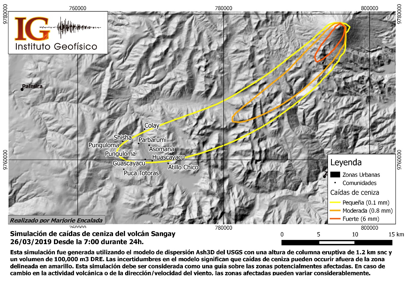
Figure 2. Ash column dispersion simulation reported by Washington VAAC (https://www.ssd.noaa.gov/VAAC/messages.html), using USGS Ash3D software, Source: IG EPN / 2019
Acoustic seismic activity:
After the final eruptive phase of the volcano that ended on December 7, 2018 with two explosions, an average of about 3 events per day was recorded and in the last month an average of about 1 event per day, these earthquakes are mainly of the volcano-tectonic type (related to the fracture of the rock) and of long-period type (related to the movement of the fluids). Since mid-December 2018, the reference station of the volcano poses technical problems and therefore works at 50% of the time, intermittently. Figure 3 shows the seismic activity of the Sangay volcano from November 2018 to March 22, 2019.
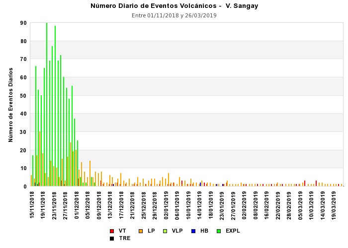
Figure 3. Bar chart showing the number of seismic events recorded by SAGA station since November 2018. No recording is available before November 16 due to technical problems at the station.
Due to the technical problems mentioned above, there is no seismic record of the problem reported by the VAAC of Washington today.
Interpretation:
According to these data, the volcano could start a new eruptive phase. The Institute of Geophysics recommends that people who frequent mountain tourism on volcanoes not to approach it, in particular it is recommended NOT to CLIMB for any reason whatsoever towards the crater and / or on the flanks in the upper part of the volcano.
Source : MA, ME, JS, PR, BB, GP
Institut de géophysique
Ecole Polytechnique Nationale.
Indonésie , Kerinci :
VOLCANO OBSERVATORY NOTICE FOR AVIATION – VONA.
Issued: April 03 , 2019
Volcano: Kerinci (261170)
Current Aviation Colour Code: YELLOW
Previous Aviation Colour Code: orange
Source: Kerinci Volcano Observatory
Notice Number: 2019KER13
Volcano Location: S 01 deg 41 min 49 sec E 101 deg 15 min 50 sec
Area: Jambi, West Sumatra, Indonesia
Summit Elevation: 12176 FT (3805 M)
Volcanic Activity Summary:
observed brown ash emission at 09:37 UTC (16:37 local time )
Volcanic Cloud Height:
Best estimate of ash-cloud top is around 25952 FT (8110 M) above sea level, may be higher than what can be observed clearly. Source of height data: ground observer.
Other Volcanic Cloud Information:
ash plume moving northeast.
Remarks:
Seismicity dominated by continuous volcanic tremor with maximum amplitude of 0.5 – 2 mm (dominant 1 mm).
Level of activity at Level II (WASPADA). The Kerinci (3805 m altitude) undergoes a continuous eruption.
Since yesterday and until this morning, the volcano was clearly visible until it was covered with fog. It was observed that the smoke from the crater was white in color, strong pressure, thick, and was about 200-300 meters above the summit. The wind is blowing moderately to the northeast.
The seismographs, April 2, 2019, recorded:
5 shallow volcanic earthquakes.
184 earthquakes explosion.
Tremor continuous with an amplitude of 0.5 – 2 mm, dominating 1 mm.
Recommendation: Communities around G. Kerinci and visitors / tourists should not move within 3 km radius of crater. In the rainy season, residents of the river flowing from G. Kerinci should be alert to the potential threat of secondary hazards in the form of descent of lahars.
Source : Magma Indonésie , PVMBG.
Photo : Wild Sumatra.
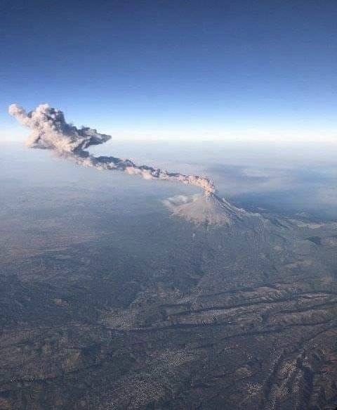
Mexico , Popocatepetl :
19.023°N, 98.622°W
Elevation 5393 m
CENAPRED reported that each day during 26 March-2 April there were 27-200 steam-and-gas emissions from Popocatépetl, some of which contained ash. An explosion at 1923 on 26 March produced an ash plume that rose 3 km above the crater rim and drifted NE, and ejected incandescent fragments 2 km onto the flanks setting fire to pastures on the N and NE flanks. Ashfall was reported in municipalities of Puebla including Santa Cruz, Atlixco (23 km SE), San Pedro, San Andrés Cholula (35 km E), Santa Isabel (45 km ESE), and San Pedro Benito Juárez (10-12 km SE), and in municipalities of Morelos including Hueyapan (17 km SSW) and Tetela del Volcán (20 km SW). An explosion at 0650 on 28 March generated an ash plume that rose 2.5 km and drifted SE, and ejected fragments 1 km onto the flanks. Continuous gas-and-ash emissions were visible between 0538 and 0748. CENAPRED raised the Alert Level to Yellow, Phase Three (middle level on a three-color scale). An ash plume from an explosion at 1948 rose 3 km and drifted SE. Incandescent fragments were ejected 2 km onto the flanks. After that event gas-and-ash plumes rose from the crater until 2010. A period of Strombolian activity began at 0247 on 30 March and lasted for 14 minutes, generating ash plumes that rose 800 m and drifted SE. Incandescent ejecta fell onto the flanks 300 m below the crater rim. During an overflight scientists observed that the diameter of the inner crater had increased to 350 m, and that the crater floor was 250-300 m deep.
03 avril, 11h00 (03 avril, 17h00 GMT)
Au cours des dernières 24 heures, 16 exhalations ont été identifiées à l’aide des systèmes de surveillance du volcan Popocatépetl, accompagnées de vapeur d’eau et de gaz volcaniques . En outre, 4 tremblements de terre de type volcano-tectonique ont été enregistrés hier à 10:17, 10:47, 11:59 et 13:04, avec une magnitude calculée respectivement de 1,4, 1,5, 1,7 et 1,3, ainsi que 813 minutes de tremor de faible amplitude, cet épisode de tremor ayant été accompagné par l’émission de gaz volcaniques et de cendres qui se sont dispersées vers l’Est-Sud-Est .
Pendant la nuit, aucune incandescence n’a été observée sur le cratère.
Au cours de la matinée, une émission continue de vapeur d’eau et de gaz a été observée, en direction Nord-Est .
Le CENAPRED demande instamment de NE PAS APPROCHER le volcan et surtout le cratère, en raison du risque de chute de fragments balistiques et en cas de fortes pluies, de s’éloigner du fond des ravins en raison du danger de coulées de boue et de débris.
Le sémaphore d’alerte volcanique Popocatepetl est situé dans la PHASE 3 JAUNE.
Source: Centre National de Prévention de Désastres (CENAPRED), GVP