January 20 , 2022.
Tonga Islands , Hunga Tonga-Hunga Ha’apai :
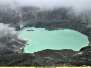
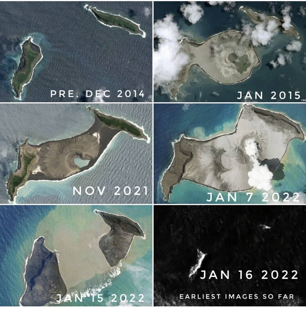
Large eruptions at Hunga Tonga-Hunga Ha’apai on both 14 and 15 January produced plumes that reached the stratosphere and caused significant regional effects. Activity on the 14th apparently removed approximately the middle third of the island that had been expanded over the previous few weeks, revealed by a Planet Lab image acquired at 15h25 on 15 January. About two hours after that image was taken an even stronger eruption activity produced a stratospheric plume seen in satellite images, sent pressure waves across the atmosphere, and caused tsunami that traversed the Pacific. Following these explosions, a Sentinel image acquired on 17 January showed that most of the previous combined island had been destroyed, leaving only small parts of the NE island of Hunga Tonga (200 m long) and the SW island of Hunga Ha’apai (700 m long) above the ocean surface.
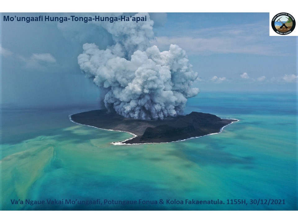
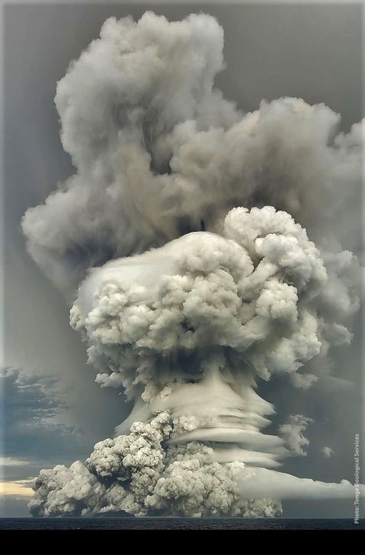
A sub-aerial eruption that began at 04h20 on 14 January produced mushroom-shaped ash, steam, and gas plumes that rose as high as 20 km (65,600 ft) a.s.l., into the stratosphere, and expanded radially at the top of the plume to 240 m in diameter, according to the Tonga Geological Services (TGS). Geologists observing from a boat around 17h00-18h30 in the afternoon noted that the plume was about 5 km wide at its base, with Surtseyan pulses ejecting dark dense material into the air, and pyroclastic flows expanding over the ocean. The eruption plume drifted over the island groups of Tongatapu, ‘Eua, Ha’apai, and Vava’u, carrying an estimated sulfur dioxide mass of 0.05 Tg (50,000 tonnes) based on satellite data. Sulfur odors were reported in Tongatapu (70 km S), near the capital on Motutapu Island, and on ‘Eua (106 km SSE). Ashfall was reported on many islands, including Fonoi and Mango (75 km ENE). The Tonga Meteorological Services (TMS) issued tsunami warnings for areas including ‘otu Mu’omu’a in Ha’apai (Nomuka, Mango, Fonoifua), ‘Atataa, ‘Eueiki, and Tongatapu mo ‘Eua. At 20h00 on 14 January a tsunami with a height of 20 cm was recorded by the Nuku’olofa tide gauge. TMS warned residents to stay away from low-lying coastal areas, beaches, and harbors. The Wellington VAAC noted that the eruption was intermittent during 00h43-06h04 on 15 January; plumes rose to altitudes of 14 km (45,900 ft) a.s.l. The Global Lightning Detection Network (GLD360) ground-based network detected 191,309 lightning events during a 21-hour period (03h34 on 14 January-01h34 on 15 January), or up to 30,000 events per hour; for comparison, during 22-28 December 2018 the partial collapse eruption of Krakatau generated 337,000 events. TGS noted that at 07h20 on 15 January an eruption lasting 10-15 minutes sent an ash plume to 14 km (45,900 ft) a.s.l. that drifted E.
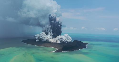
A larger, submarine eruption began at 17h00 on 15 January. According to news reports and social media posts, residents in Nuku’alofa (65 km S) heard multiple loud booms and saw a large expanding eruption plume that eventually covered all of the Tongan islands. According to the Wellington VAAC the plume had risen to 15.2 km (50,000 ft) a.s.l. by 18h19; the top of the plume as seen in satellite images was at least 600 km in diameter by 19h03. During 17h19-23h00 there were almost 400,000 lightning events recorded in the plume by the GLD360 network, with 200,000 of those during 18h00-19h00. By 03h43 on 16 January the plume had risen to 19.2 km (63,000 ft) a.s.l. Analysis of other satellite datasets suggested that the plume may have risen to 30 km (98,400) a.s.l. The sulfur dioxide mass of the plume was 0.4 Tg (400,000 tonnes) derived from satellite-based estimates; the cloud drifted W consistent with stratospheric winds. Significant ashfall was reported on populated islands of Tonga, 70-100 km E. News articles noted that some residents had difficulty breathing from the ash in the air.
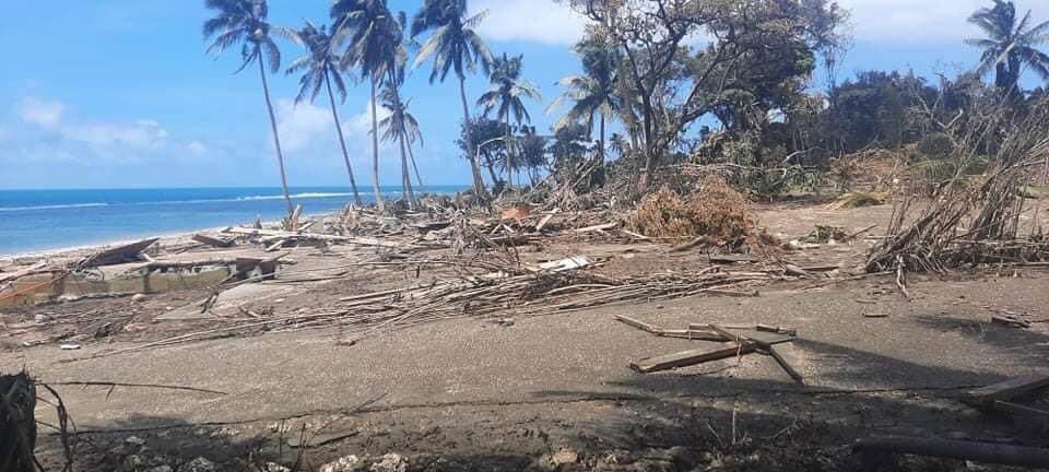
Most domestic and international communications on the islands were severed due to a break in an underwater cable, and ashfall has delayed both damage assessment and relief assistance. An update on 18 January from the Government of Tonga provided details about the eruption and its effects, noting that tsunami warnings issued after the eruption began had triggered evacuations. Tsunami waves up to 2 m high, based on a news article, arrived on the W coasts of the Tongatapu, ‘Eua, and Ha’apai islands, and three people in Tonga were confirmed to have died as a result, with many others injured. Extensive damage was reported on Mango, Fonoifua, and Nomuka islands, and on the W part of Tongatapu. Aerial surveillance by the New Zealand Defence Force’s showed brown, damaged vegetation and landscapes, debris, and modified coastlines with sediment-laden waters.
The Government of Tonga also noted that communications to the outer islands were accomplished with a patrol boat on 17 January, and limited communication with residents of Vava’u and Ha’apai was possible the next day. Evacuation efforts were underway for some remote islands. Ashfall contaminated fresh water supplies, hindered sea transportation and harbor access, and caused flights to be cancelled. According to a news report the small island of Atata, near Nuku’alofa, had been completely submerged. Tsunami warnings were also issued in several other countries surrounding the Pacific Ocean. Several news sources reported flooding and damage caused by the tsunamis at locations as far away as Peru (over 10,000 km), where it caused two deaths. Warnings were issued for the N and E coasts of New Zealand’s North Island and the Chatham Islands; multiple boats were destroyed. Thousands in Japan evacuated after tsunami warnings, and the waves there reached 80 cm, disrupting train services, flights, and damaging harbors and boats. In Anchorage, Alaska, the US National Weather Service reported maximum waves heights of 20-100 cm on Alaskan coastlines, and along the British Columbia coast waves were 16-29 cm on 15 January.
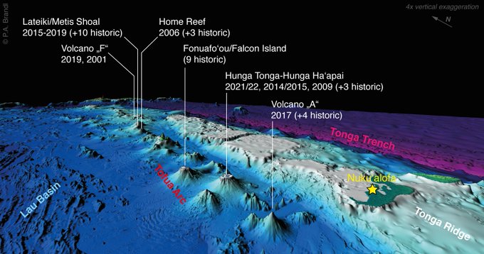
3D bathymetric image of the central Tofua arc in Tonga islands with known submarine volcanic eruptions (since 2000). Volcanic activity is not uncommon but the recent HungaTongaHungaHaapai eruption was much bigger than any historic event in the region.
The explosions produced multiple pressure (shock) waves that rippled through surrounding weather clouds, though the pressure wave from the largest explosion propagated across the planet. The sonic boom from this wave was heard at great distances, including in Fiji (about 500 km NW), within about two hours in New Zealand (1,600-2,000 km), and within about nine hours in Alaska, USA (9,370 km NE). The pressure wave was also recorded by infrasound and weather instruments worldwide as it circled the Earth, with instruments picking up the wave a second time as it arrived from the opposite direction. Very small perturbances in the ocean waves recorded in the Caribbean, which some referred to as meteotsunamis, were likely generated by atmospheric disturbances from the pressure waves after they passed over South America.
Source : GVP.
Photos : Tonga Geological Services, Government of Tonga , Patrice Zwenger , My Tongan / FDB , Taaniela Kula/TGS. Taken from Matangi Tonga Online, Philipp Brandl .
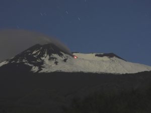
Italy / Sicily , Etna :
WEEKLY BULLETIN, from January 10, 2022 to January 16, 2022 (Date of issue January 18, 2022)
ACTIVITY STATUS SUMMARY
In the light of the surveillance data, it is highlighted:
1) VOLCANOLOGICAL OBSERVATIONS: Degassing activity at variable rate of all the summit craters.
2) SEISMOLOGY: Absence of fracturing seismic activity with Ml >= 2.0; average amplitude of the volcanic tremor on the low level.
3) INFRASOUND: medium low infrasound activity.
4) GROUND DEFORMATIONS: There are no significant variations during the last week
5) GEOCHEMISTRY: SO2 flux at a medium-low level
CO2 flux at an average level
Isotope ratio of helium on medium to high values
CO2 in groundwater under seasonal variability
6) SATELLITE OBSERVATIONS: The thermal activity in the summit area observed by satellite was at a low level.
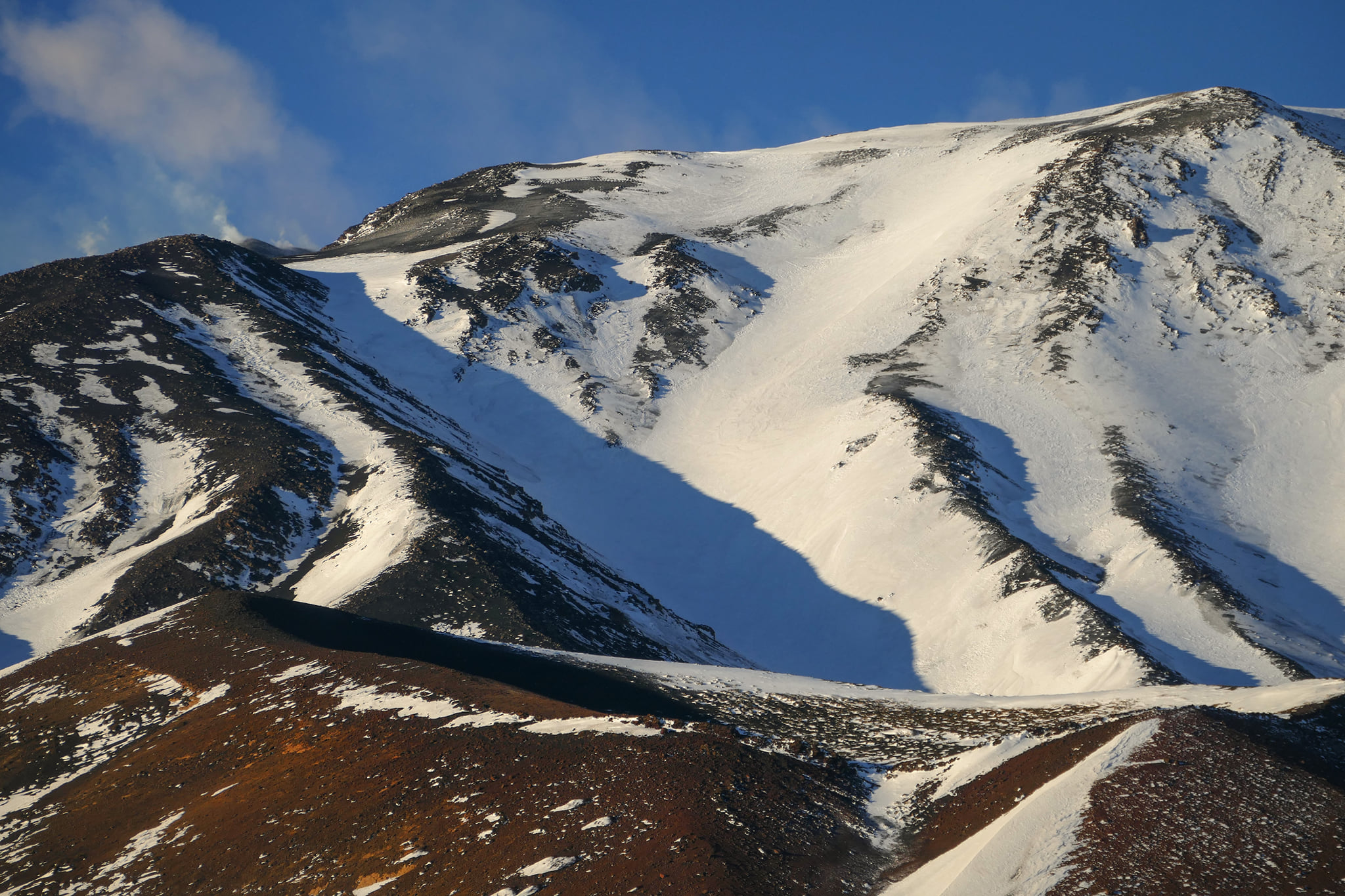
VOLCANOLOGICAL OBSERVATIONS
During the week under review, the monitoring of Etna’s volcanic activity was carried out thanks to the analysis of images from the network of INGV surveillance cameras, Etneo Observatory (INGV-OE).
Overall, the state of activity of the summit craters showed no change from what was observed the previous week (see Rep. N. 02/2022). In particular, the degassing activity of the summit craters was mainly carried out by the collapse crater located in the northwest sector of Bocca Nuova, characterized by intense, sometimes impulsive degassing. The Voragine and Southeast Crater craters, on the other hand, showed predominant degassing related to fumarole systems present along the edges of the crater. Finally, the Northeast Crater was affected by a small ash emission on the morning of December 16.
Source : INGV.
Photo : Gio Giusa .
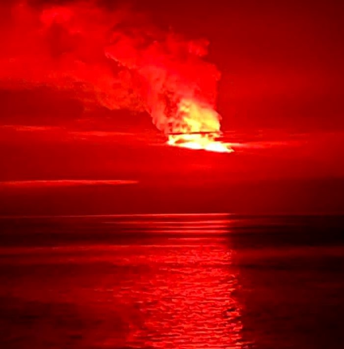
Ecuador / Galapagos , Wolf :
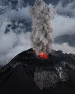
On 13 January IG reported that the eruption at Wolf was continuing, but at decreasing levels. Lava from at least three fissures had traveled about 16.5 km SE, and covered an estimated 7.4 square kilometers, but had not reached the coast. Daily counts of thermal anomalies were in the hundreds but had progressively decreased in quantity and intensity in recent days, interpreted as a decrease in the effusion rate and cooling flows. Notices of ash-and-gas plumes were issued by the Washington VAAC on 7-8 January, noting that plumes decreased from 2.6 km to 300 m above the vent. Additionally, sulfur dioxide emissions decreased from 60,000 tons per days recorded on 7 January to 8,100 tons per day on 12 January. Seismicity also trended downward.
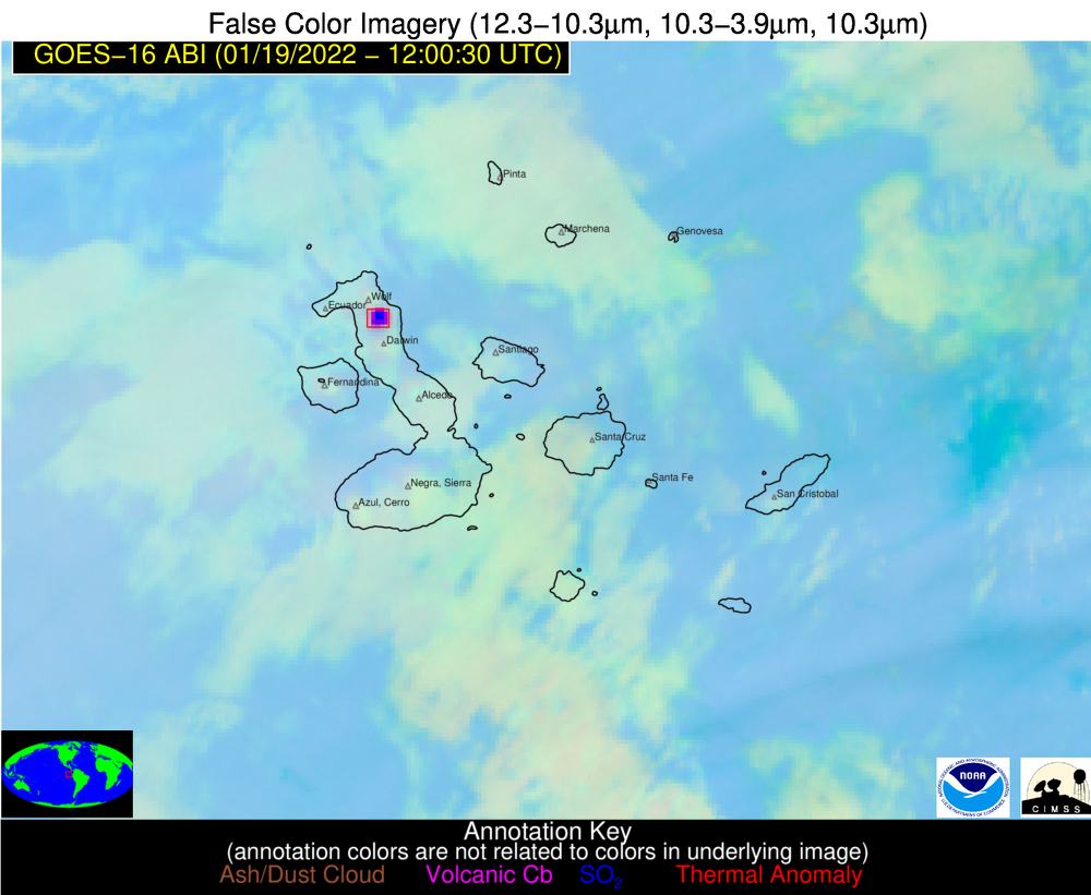
DAILY REPORT OF THE STATE OF WOLF VOLCANO. January 19, 2022.
Surface Activity Level: High, Surface Trend: Unchanged
Internal activity level: High, Internal trend: No change.
Seismicity: From January 18, 2022, 11:00 a.m. to January 19, 2022, 11:00 a.m.:
Long period type (VT): 3
Emission / ash column:
Thanks to the satellites, it was possible to observe slight gas emissions towards the South-West during the last 24 hours.
Other Monitoring Parameters:
MIROVA reports 2 extreme thermal alerts (15119 and 14727 MW), 1 moderate and 1 high (390 MW) and FIRMS reports hundreds of thermal alerts in the last 24 hours
Comments
According to satellite monitoring, it is observed that the thermal anomalies are maintained.
Source : GVP , IGEPN.
Photos : GOES , Galápagos Naciente.
Japan , Sakurajima :
JMA reported that incandescence from Minamidake Crater (at Aira Caldera’s Sakurajima volcano) was visible at night during 10-17 January. Seismic data showed a decreasing number of volcanic earthquakes. The Alert Level remained at 3 (on a 5-level scale), and residents were warned to stay 2 km away from the crater.
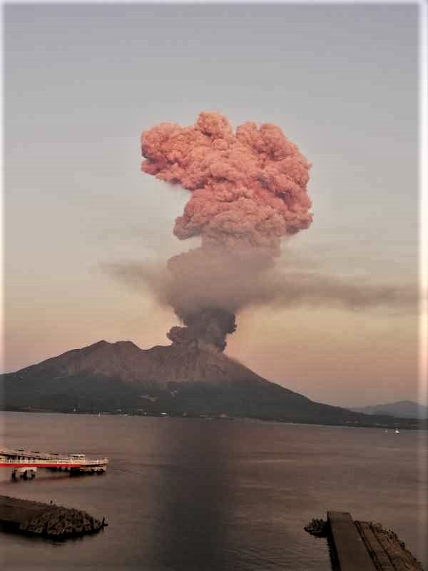
The Aira caldera in the northern half of Kagoshima Bay contains the post-caldera Sakurajima volcano, one of Japan’s most active. Eruption of the voluminous Ito pyroclastic flow accompanied formation of the 17 x 23 km caldera about 22,000 years ago. The smaller Wakamiko caldera was formed during the early Holocene in the NE corner of the Aira caldera, along with several post-caldera cones. The construction of Sakurajima began about 13,000 years ago on the southern rim of Aira caldera and built an island that was finally joined to the Osumi Peninsula during the major explosive and effusive eruption of 1914. Activity at the Kitadake summit cone ended about 4850 years ago, after which eruptions took place at Minamidake. Frequent historical eruptions, recorded since the 8th century, have deposited ash on Kagoshima, one of Kyushu’s largest cities, located across Kagoshima Bay only 8 km from the summit. The largest historical eruption took place during 1471-76.
Source : GVP, Agence météorologique japonaise (JMA), Tokyo Volcanic Ash Advisory Center (VAAC)
Photo : @volcanohull / public domain / Volcanodiscovery.
Indonesia , Semeru :
PVMBG reported that the eruption at Semeru continued during 12-17 January. White steam plumes that were sometimes dense rose as high as 1 km above the summit almost daily, and crater incandescence was visible nightly. Incandescent avalanches traveled as far as 500 m down the Kobokan drainage on the SE flank during 11-12 January. White-and-gray ash plumes rose 300 m during 14-15 January.
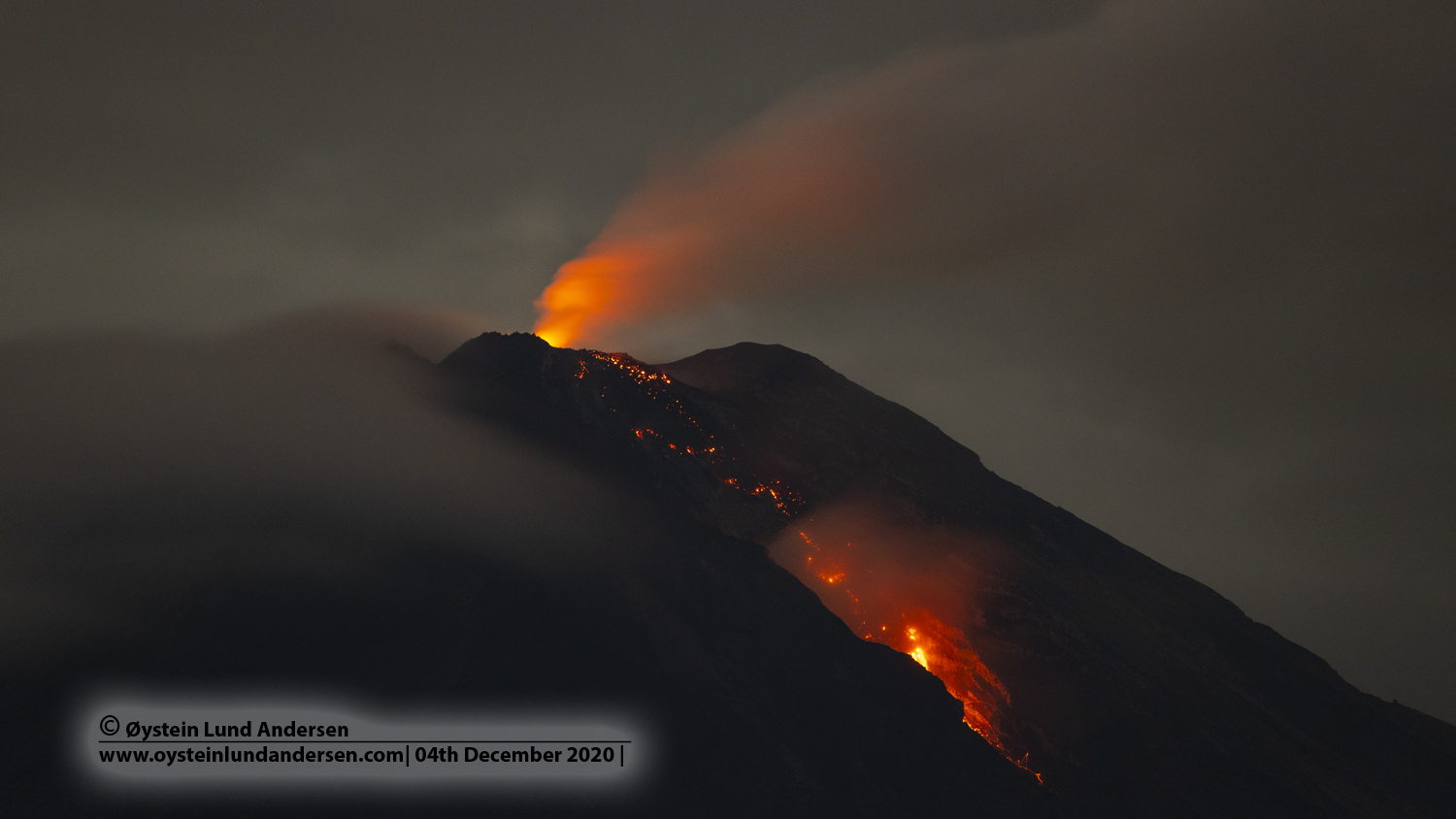
At 10h20 on 16 January a collapse from the end of the active lava flow in the Kobokan drainage produced a pyroclastic flow, and an ash plume that rose 1.5 km and drifted North. An eruptive event at 05h34 on 17 January generated an ash plume that a ground observer reported rising 400 m. The Alert Level remained at 3 (on a scale of 1-4). The public was warned to stay at least 500 m away from Kobokan drainages within 17 km of the summit, along with other drainages originating on Semeru, including the Bang, Kembar, and Sat, due to lahar, avalanche, and pyroclastic flow hazards.
Source : GVP
Photo : Oystein lund Andersen .