November 30 , 2021.
Peru , Sabancaya :
Analysis period: November 22, 2021 to November 28, 2021, Arequipa, November 29, 2021.
Alert level: ORANGE
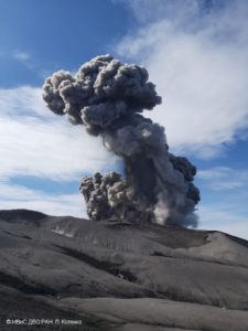
The Geophysical Institute of Peru (IGP) reports that the eruptive activity of the Sabancaya volcano remains at moderate levels, that is to say with the recording of an average of 73 daily explosions, with columns of ash and gas up to an altitude of 2.0 km above the summit of the volcano and their consequent dispersion. Therefore, for the following days, no significant change is expected in eruptive activity.

The IGP recorded and analyzed the occurrence of 660 earthquakes of volcanic origin, associated with the circulation of magmatic fluids within the Sabancaya volcano. An average of 73 explosions was recorded daily. During this period, Volcano-Tectonic (VT) earthquakes associated with rock fractures were located mainly in the Northwest, North and East of Sabancaya and presented magnitudes between M 1 , 9 and M 3.7.
The monitoring of the deformation of the volcanic structure using GNSS techniques (processed with fast orbits) does not show any significant anomalies. However, in general, an inflation process was observed in the northern sector (around the Hualca Hualca volcano). Visual surveillance identified columns of gas and ash up to an altitude of 2.0 km above the summit of the volcano, which were scattered towards the South, South-West, West and North-East sectors of the volcano. Sabancaya. Satellite recordings have identified the presence of 2 thermal anomalies (maximum value of 16 MW) associated with the presence of a lava body on the surface of the volcano’s crater.
RECOMMENDATIONS
• Keep the volcanic alert level in orange.
• Do not approach within a radius of 12 km from the crater.
Source : IGP
Photo : Ingemmet
Spain / La Palma , Cumbre Vieja :
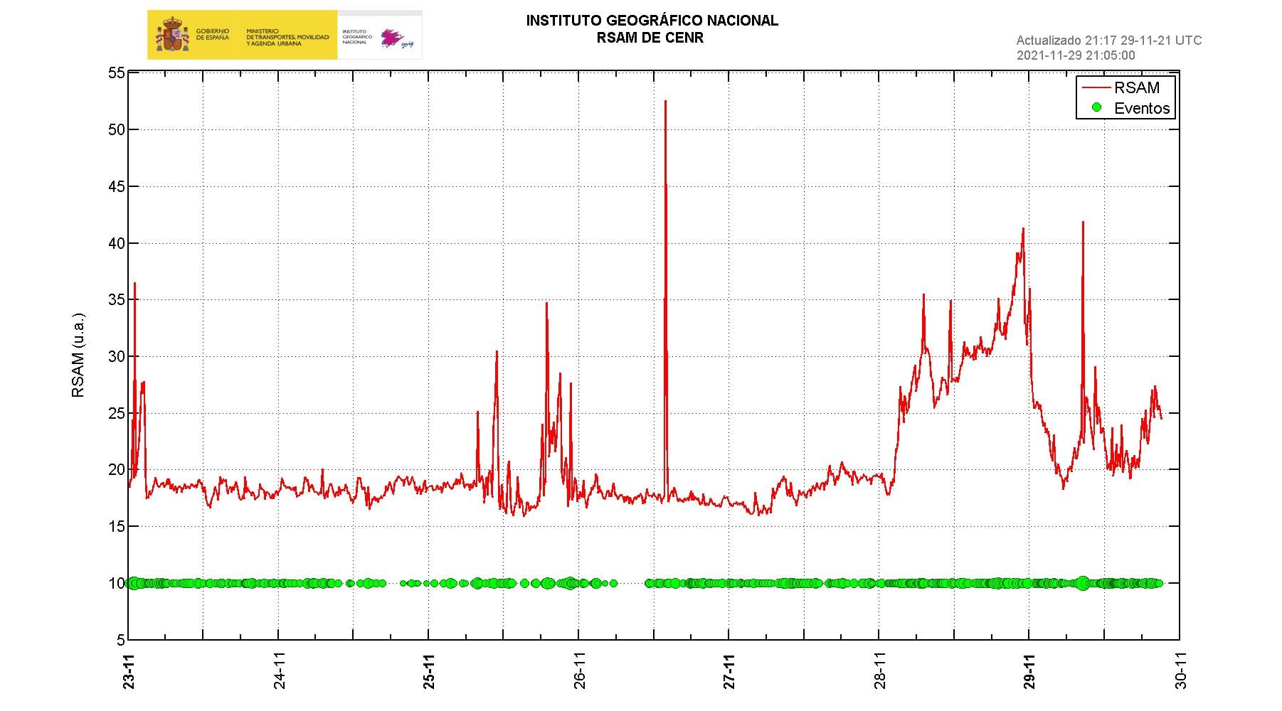
November 29, 2021, 09:00 UTC. Eruptive activity continues on La Palma.
Since the last declaration, a total of 128 earthquakes have been located in the area affected by the volcanic reactivation on the island of La Palma, of which 6 were felt by the population.
Seismicity continues below the central area of Cumbre Vieja in the same areas as the previous days, 101 of these earthquakes are located at depths of 10-15 km and the rest at depths of 20 km.
The maximum recorded magnitude is 5.0 (mbLg) corresponding to today’s earthquake at 8:35 UTC, with a depth of 35 km and an intensity IV-V (EMS98).
The amplitude of the tremor signal increased yesterday. Today it has decreased to the average values of the last few days. In the last few hours, the tremor signal has increased again.
The island’s network of permanent GNSS stations shows an elevation reversal recorded between November 24 and 26 at station LP03, which is closest to the eruptive centers.
In the rest of the stations, the slight deflation possibly linked to the deep seismicity has stabilized, except in LP01 which continues to record it.
In view of the image calibrated at 09:15 UTC, a column height of 1400 m is estimated, and a cloud is diffusing in a south-southwest direction.
The height of the cone is measured by obtaining a value of 1,126 m at sea level.
A magnitude 5 earthquake rocked La Palma yesterday morning at 8:35 am with an intensity of V, the highest since the eruption began 71 days ago. The shock, produced at Villa de Mazo at a depth of 35 kilometers, is the most important of the last ten days, above three others of M 4.8 that occurred last week (22, 23 and 25 November). The National Geographic Institute reported 53 earthquakes in La Palma on Monday. The Department of Internal Security warned, as yesterday the General Directorate of Security and Emergencies, through the volcanic emergency plan of the Canary Islands (Pevolca), against a « very unfavorable » air quality in due to the increase in sulfur dioxide (SO2) in Tazacorte, Los Llanos de Aridane and El Paso.
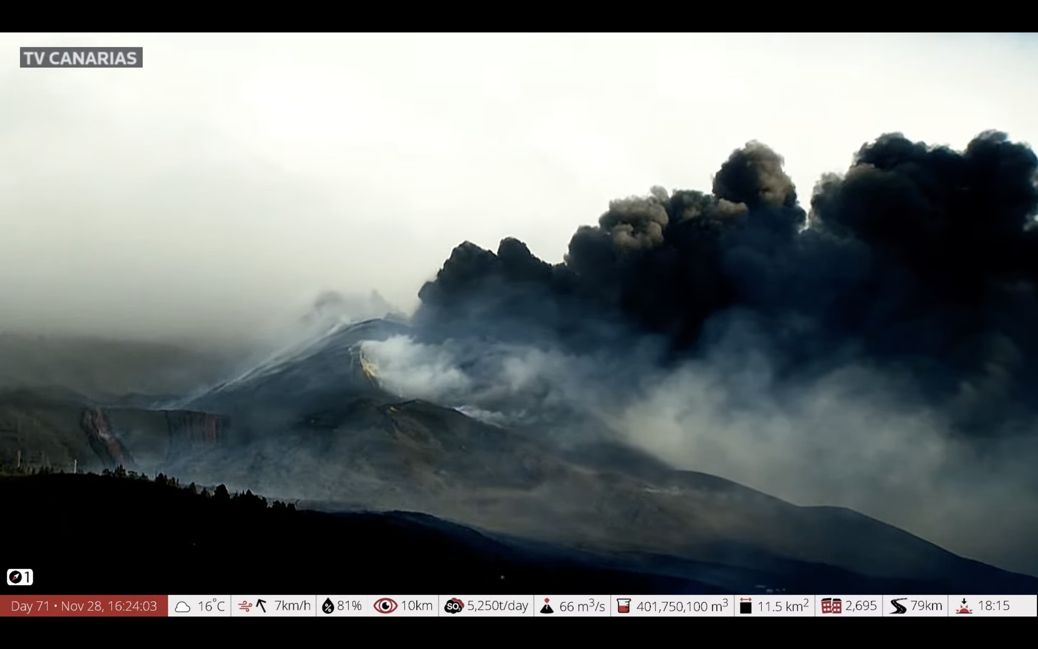
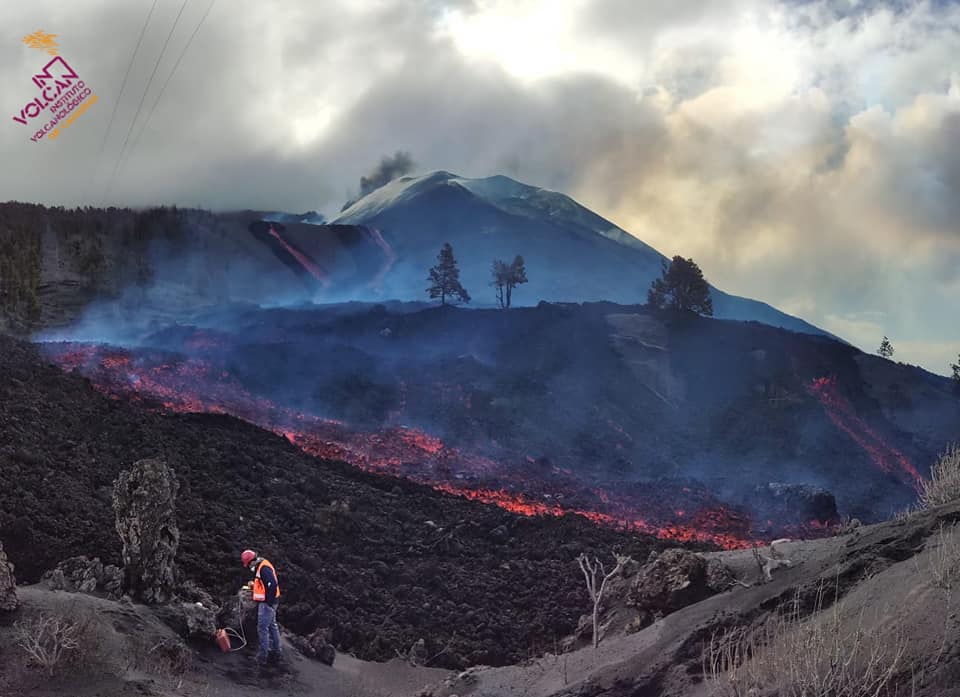
– Volcanic activity has significantly decreased in the effusive focus located on the northwest flank of the main cone, although it continues to feed the lava tubes. The rest of the major emission centers have significantly reduced their activity which is currently mainly focused on the new eruptive foci that opened yesterday.
– From the new south-easternmost crack which bears an approximate east-west orientation, a lava arm has been emitted which branches off into the upper zone. One of the branches is circulating slowly over the old flows and another has overflowed into the northern area and could affect La Laguna.
-The seismicity at intermediate depths has increased over the past 24 hours and continues to be located in the same areas. At depths greater than 20 km, it remains at low levels. The maximum magnitude was 5.0 for an event recorded this Monday at 8:35 am, at a depth of 35 kilometers.
The volcano of La Palma appears to have shifted its activity from the main cone to the secondary, since the first of them stopped emitting lava on Monday, Itahiza Domínguez, of the National Geographic Institute (IGN ) on social networks.
Over a hundred earthquakes rock the island in the early hours of the morning. Seismicity increases at intermediate depths on La Palma. The island has recorded more than 100 earthquakes since last midnight, including 29 above magnitude 3, reports the Institute of Geosciences through social media. The strongest reached a magnitude of 4.1.
Sources : IGNes , El Pais .
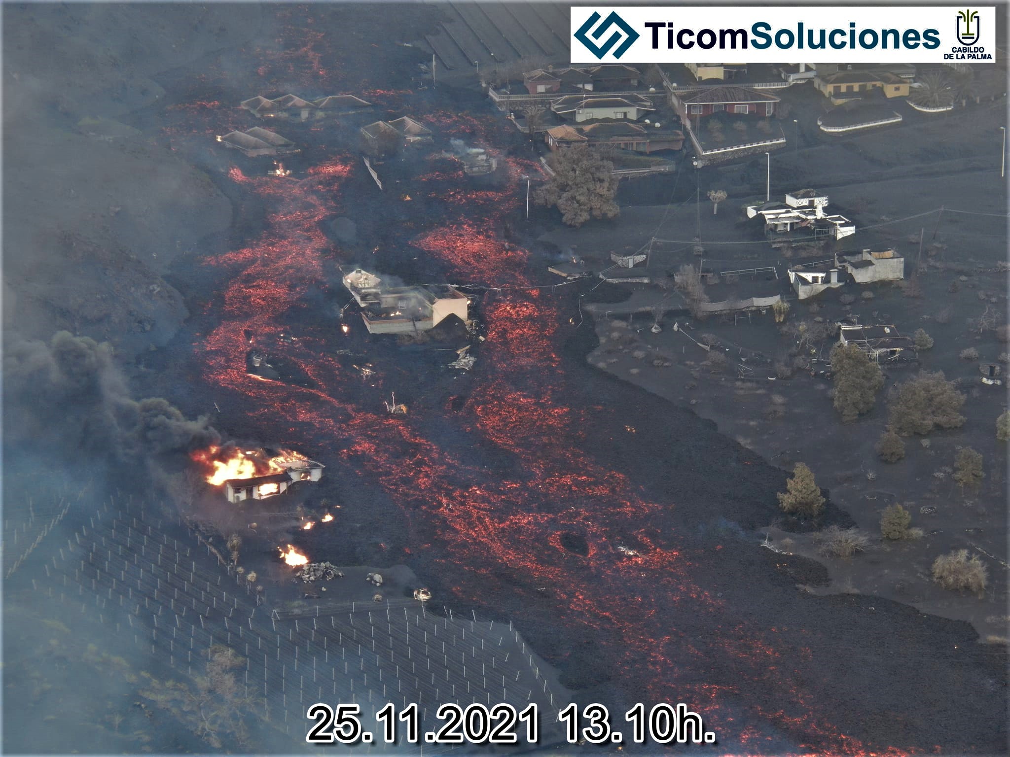
Photos : Involcan , TV Canarias , Ticomsoluciones.
Graphique : IGN
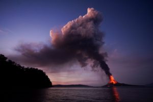
Philippines , Taal :
TAAL VOLCANO BULLETIN 30 November 2021 8:00 AM
In the past 24-hour period, the Taal Volcano Network recorded twenty-one (21) volcanic earthquakes, including eleven (11) volcanic tremor events having durations of 2 to 10 minutes, six (6) low-frequency volcanic earthquakes, four (4) hybrid events and low-level background tremor that has persisted since July 7, 2021. Activity at the Main Crater was dominated by upwelling of hot volcanic fluids in its lake which generated plumes 1500 meters tall that drifted southwest. Sulfur dioxide (SO2) emission averaged 5,228 tonnes/day on 29 November 2021. Based on ground deformation parameters from electronic tilt, continuous GPS and InSAR monitoring, Taal Volcano Island and the Taal region has begun deflating in October 2021.
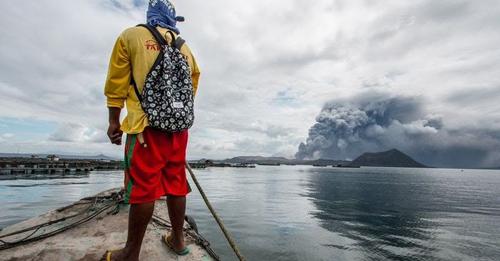
Alert Level 2 (Increased Unrest) prevails over Taal Volcano. DOST-PHIVOLCS reminds the public that at Alert Level 2, sudden steam- or gas-driven explosions, volcanic earthquakes, minor ashfall, and lethal accumulations or expulsions of volcanic gas can occur and threaten areas within and around TVI. DOST-PHIVOLCS strongly recommends that entry into Taal Volcano Island, Taal’s Permanent Danger Zone or PDZ must be strictly prohibited, especially the vicinities of the Main Crater and the Daang Kastila fissure, and extended stays on Taal Lake.
Source : Phivolcs.
Photo : Philstar.
Ecuador , Cotopaxi :
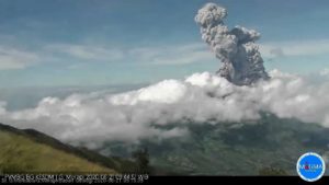
Informative VOLCANO COTOPAXI, SUNDAY, NOVEMBER 28, 2021.
From 11:00 (TL), via the cameras of the IG-EPN, an emission of water vapor and gas was observed from the crater of the Cotopaxi volcano, reaching 800 meters above the summit level . These emissions are associated with the intense precipitation that has occurred in the region in recent days to vaporize. The dominant direction of the winds to the North-West and to the North makes the gases perceived by the people staying in the upper zone of the volcano.
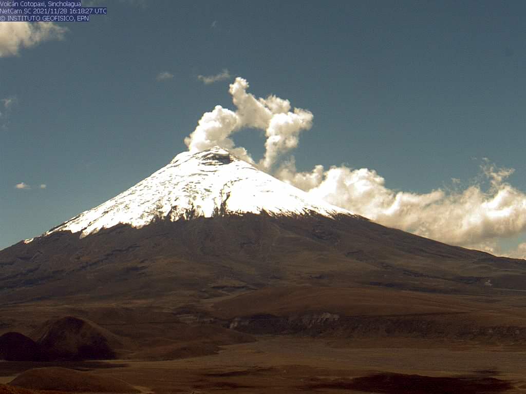
No change was recorded in the interior activity of the volcano or in other monitoring parameters. The IG-EPN continues to monitor the event and report any changes in the activity of the volcano.
Hawaii , Kilauea :
19°25’16 » N 155°17’13 » W,
Summit Elevation 4091 ft (1247 m)
Current Volcano Alert Level: WATCH
Current Aviation Color Code: ORANGE
Activity Summary:
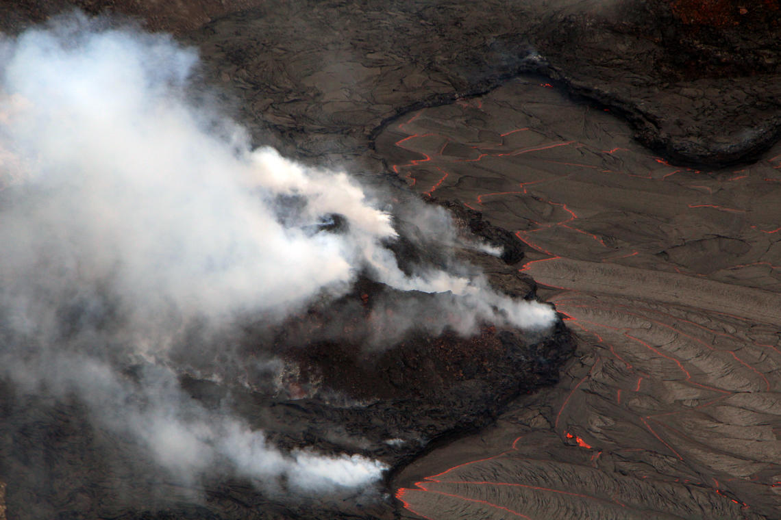
Kīlauea volcano is erupting from a single vent in the western wall of Halemaʻumaʻu crater. As of this morning, November 29, 2021, all lava activity is confined within Halemaʻumaʻu crater in Hawai‘i Volcanoes National Park. Seismic activity and volcanic gas emission rates remain elevated.
Summit Observations:
Sulfur dioxide (SO2) emission rates remain elevated, with an emission rate for November 23, 2021, of approximately 6400 tonnes per day. The average SO2 emission rate for recent weeks is approximately 3000 tonnes per day. Summit tiltmeters overall recorded net deflation over past day. Seismicity remains stable. Earthquake activity remains below background and volcanic tremor remains elevated since the beginning of the eruption.
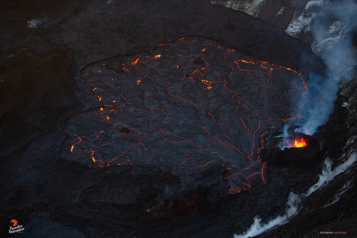
View from the south looking at the active west vent in Halema‘uma‘u at Kīlauea summit. The vent is mostly obscured by a plume of steam and sulfur dioxide, with a little spatter visible. A lava flow is slowly entering the lava lake from the base of the scoria cone that has been constructed around the west vent.
Halemaʻumaʻu Lava Lake Observations:
Lava continues to erupt from a single vent in the western wall of Halemaʻumaʻu crater, while the eastern edge of the lake continues to advance onto the lowest of the exposed down-dropped caldera floor blocks. The western end of the lake showed a maximum elevation of approximately 809 meters (2654 ft) above sea level by HVO’s permanent laser rangefinder this morning, and a total increase of over 65 meters (213 ft) since lava emerged on September 29, 2021. Webcams show spatter and ponded lava within the west vent, an area of active lava at the surface of the lava lake, and sporadic oozes of lava along the cooler outer lake margins. The total erupted volume since the beginning of the eruption was estimated to be about 30 million cubic meters (7.8 billion gallons) on November 16, 2021.
Source : HVO.
Photos : Bruce Omori , USGS / D. Downs.