November 27 , 2021.
Spain / La Palma , Cumbre Vieja :
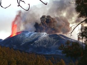
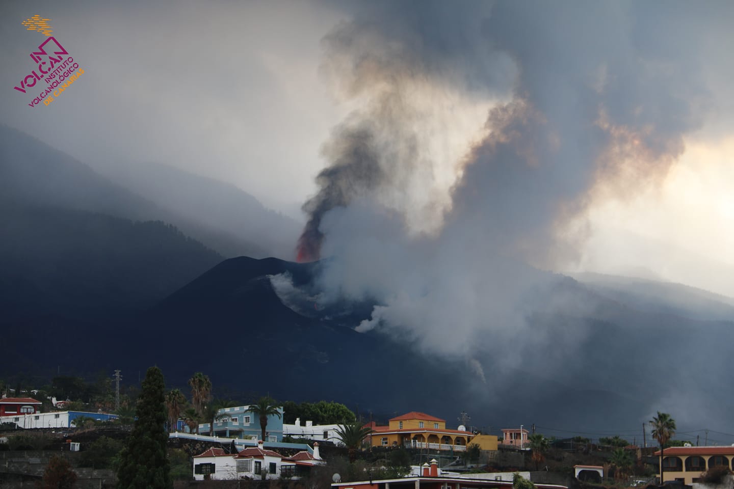
November 26, 2021 09:00 UTC. Eruptive activity continues on La Palma.
Since the last declaration, a total of 44 earthquakes have been located in the area affected by the volcanic reactivation on the island of La Palma, of which 5 were felt by the population.
Seismicity continues below the central area of Cumbre Vieja in the same areas as the previous days, most earthquakes are located at depths of 10-15 km and only 7 of them at depths greater than 30 km .
The maximum recorded magnitude is 4.8 (mbLg) corresponding to yesterday’s earthquake at 22:40 UTC, with a depth of 37 km and an intensity IV-V (EMS98).
The amplitude of the volcanic tremor signal continues at low average levels with fluctuations coinciding with the effusive episodes observed yesterday.
The network of permanent GNSS stations shows vertical uplift movements at the stations closest to the eruptive centers, the magnitude of which remains to be confirmed due to unfavorable weather conditions.
In the rest of the stations, the slight deflation possibly linked to the deep seismicity has stabilized, except in LP01 which continues to record it.
In view of the image calibrated at 07:36 UTC, a column height of 3500 m is estimated, with a scatter cloud in the easterly direction.
The height of the cone is measured by obtaining a value of 1,126 m at sea level.
Yesterday at 15:51 UTC, due to the decrease in the height of the eruptive column, the IGN issued a new VONA (Volcano Observatory Notice for Aviation) message indicating that the said height was 3,500 m above sea level.
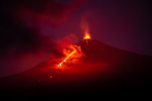
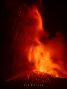
The volcano of La Palma does not give respite to the inhabitants of the island. The lava flows which overflowed yesterday Thursday from the volcanic cone created a tongue which advances at considerable speed in a southwest direction along the southern flank of the eruption and passes « unfortunately, through parts of Las Manchas which ‘it had not been destroyed before,’ according to the volcanologist of the National Geographic Institute, Rubén López.
This lava tongue is the one that covered the Los Angeles cemetery (also known as Las Manchas) on Thursday noon and the one that threatens much of the area.
The seismicity frightened the population of the island last night. At around 10:40 p.m. local time, there was a 4.8 magnitude IV-V earthquake that was felt throughout the island and the three closest (La Gomera, El Hierro and Tenerife).
The La Palma volcano caused fear on Thursday, with the opening of a new eruptive focus and a fissure. These two events caused the emission of a lava tongue that eventually submerged the cemetery of Las Manchas and a photovoltaic power plant, in addition to many houses. The fissure stopped emitting lava this morning. The new focus, however, remains active (albeit « it’s completely shut down ») and, according to the Pevolca, threatens to create further outbursts.
The same is not true of the crack located less than a kilometer from the crater. « At the moment there is no visible activity anymore, » explained Pevolca science spokesperson María José Blanco. However, several emission centers of varying activity (both pyroclasts, gas and lava) are still active, and scientists do not rule out, as usual, that new vents can be opened at any time.
Sources : IGN es , El Pais.
Photos : Involcan ,
Alaska , Pavlof :
55°25’2″ N 161°53’37 » W,
Summit Elevation 8261 ft (2518 m)
Current Volcano Alert Level: WATCH
Current Aviation Color Code: ORANGE
The eruption at Pavlof Volcano continues. Elevated seismicity was detected throughout the past week and a few small explosions were detected in infrasound data over the past 48 hours. No ash emissions were detected in in mostly cloudy satellite and web camera views this week.
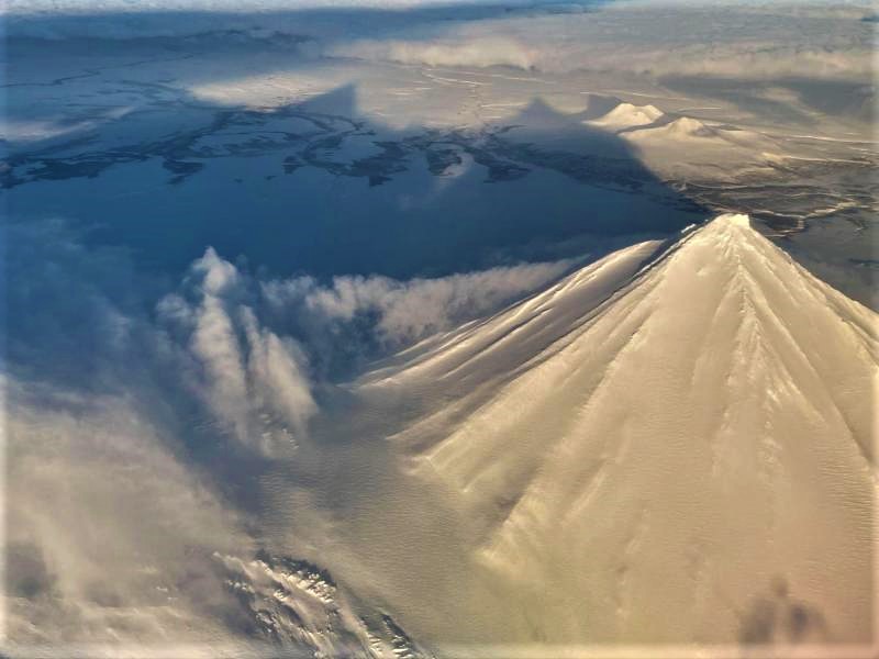
Starting Sunday, November 14, low-level lava fountaining from the vent on the upper southeast flank has built a small cone of hot unstable debris. Debris from the cone has formed hot flows that extend a few hundred meters below the vent. Strong to moderately elevated surface temperatures that were observed in satellite data throughout the week, even through cloud cover, suggest that this activity continues. These hot rubbly lava flows melt snow and ice, and the meltwater combines with debris to form thin, watery debris flows, or lahars, that extend down the flank for several kilometers. High resolution satellite data from Thursday, November 25, shows a new debris flow extending from the lava flow coming from the active vent.
The level of unrest at Pavlof can change quickly and the progression to more significant eruptive activity can occur with little or no warning.
Pavlof is monitored by local seismic and infrasound sensors, satellite data, web cameras, and remote infrasound and lightning networks.
Source : AVO.
Photo : Musselwhite, Levi .
Italy , Stromboli :
PRESS RELEASE ON THE ACTIVITY OF STROMBOLI, November 26, 2021, 10:45 a.m. (9:45 a.m. UTC).
The National Institute of Geophysics and Volcanology, Osservatorio Etneo reports that the lava overflow produced by the northern area of the terrace of the Stromboli crater continued overnight. The lava flow seemed to be well fed and the most advanced part is located in the intermediate part of the Sciara del fuoco; the material separates from the front and reaches the coast line. Finally, ordinary Strombolian activity persists in both the North and Center-South crater areas.

Since the period since the previous press release, the volcanic tremor has remained at average levels. It was only occasionally in conjunction with slightly more forceful explosions that it reached medium to high values.
The GPS and inclinometric data show no significant changes.
Further updates will be communicated shortly.
Source : INGV.
Philippines , Taal :
TAAL VOLCANO BULLETIN 27 November 2021 8:00 AM
In the past 24-hour period, the Taal Volcano Network recorded sixty-nine (69) volcanic earthquakes, including fifty-nine (59) volcanic tremor events having durations of 1 to 8 minutes, seven (7) low-frequency volcanic earthquakes, three (3) hybrid volcanic earthquakes and low-level background tremor that has persisted since July 7, 2021. Activity at the Main Crater was dominated by upwelling of hot volcanic fluids in its lake which generated plumes 600 meters tall that drifted southwest. Sulfur dioxide (SO2) emission averaged 3,229 tonnes/day on 26 November 2021. Based on ground deformation parameters from electronic tilt, continuous GPS and InSAR monitoring, Taal Volcano Island has been inflating since August 2021 while the Taal region continues to undergo very slow extension since 2020.
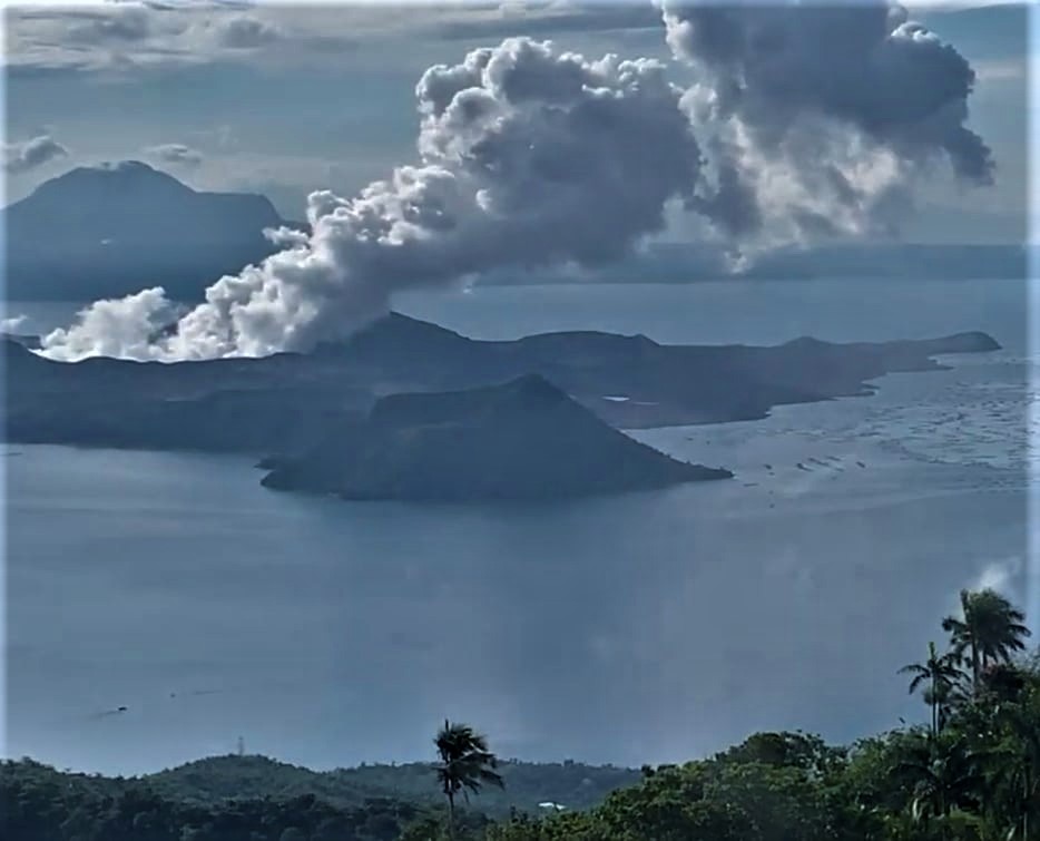
Alert Level 2 (Increased Unrest) prevails over Taal Volcano. DOST-PHIVOLCS reminds the public that at Alert Level 2, sudden steam- or gas-driven explosions, volcanic earthquakes, minor ashfall, and lethal accumulations or expulsions of volcanic gas can occur and threaten areas within and around TVI. DOST-PHIVOLCS strongly recommends that entry into Taal Volcano Island, Taal’s Permanent Danger Zone or PDZ must be strictly prohibited, especially the vicinities of the Main Crater and the Daang Kastila fissure, and extended stays on Taal Lake.
Source : Phivolcs
Photo : Kyle Aranza.
Indonesia , Merapi :
The mountain is clear, the smoke from the crater is not observed.
Incandescent lava avalanches with a sliding distance of 1,500 meters to the southwest are recorded as well as volcanic earthquakes associated with smoke emissions from the crater, avalanches and the growth of lava domes.
The seismicity of the Merapi showed this week:
– 173 avalanche earthquakes
– 7 earthquakes of emissions
– 10 multi-phase earthquakes
– 1 shallow volcanic earthquake
– 1 distant tectonic earthquake.
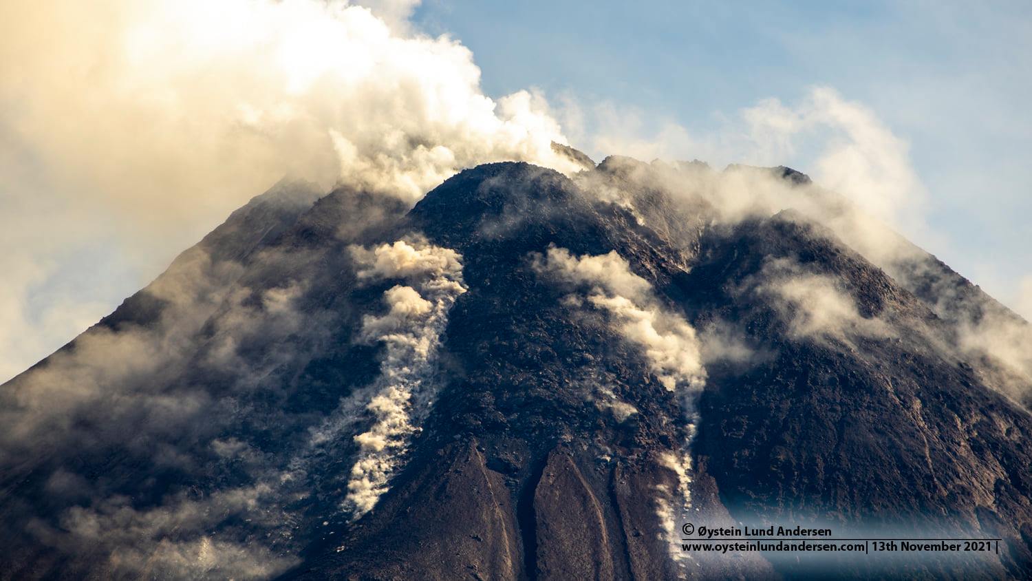
RECOMMENDATION
1. The current potential danger consists of lava avalanches and hot clouds in the South-East / South-West sector over a maximum of 3 km to the Woro river and 5 km to the Gendol rivers, Kuning, Boyong, Bedog, Krasak, Bebeng and White. During this time, the ejection of volcanic material in the event of an explosive eruption can reach a radius of 3 km from the summit.
2. The community should not carry out any activity in the area of potential danger.
3. The public should anticipate the disturbance caused by volcanic ash from the eruption of Mount Merapi and be aware of the dangers of lahars, especially when it rains around Mount Merapi.
4. It is recommended to stop mining in the channel of the river which originates on Mount Merapi.
5. Tourists are recommended not to carry out activities in areas of potential danger and crater openings up to 5 km from the summit of Mount Merapi.
6. If there is a significant change in activity, the activity status of Mount Merapi will be immediately reviewed.
Source : PVMBG.
Photo : Oystein Lund Andersen.
Hawaii , Kilauea :
19°25’16 » N 155°17’13 » W,
Summit Elevation 4091 ft (1247 m)
Current Volcano Alert Level: WATCH
Current Aviation Color Code: ORANGE
Activity Summary:
Kīlauea volcano is erupting from a single vent in the western wall of Halemaʻumaʻu crater. As of this morning, November 26, 2021, all lava activity is confined within Halemaʻumaʻu crater in Hawai‘i Volcanoes National Park. Seismic activity and volcanic gas emission rates remain elevated.
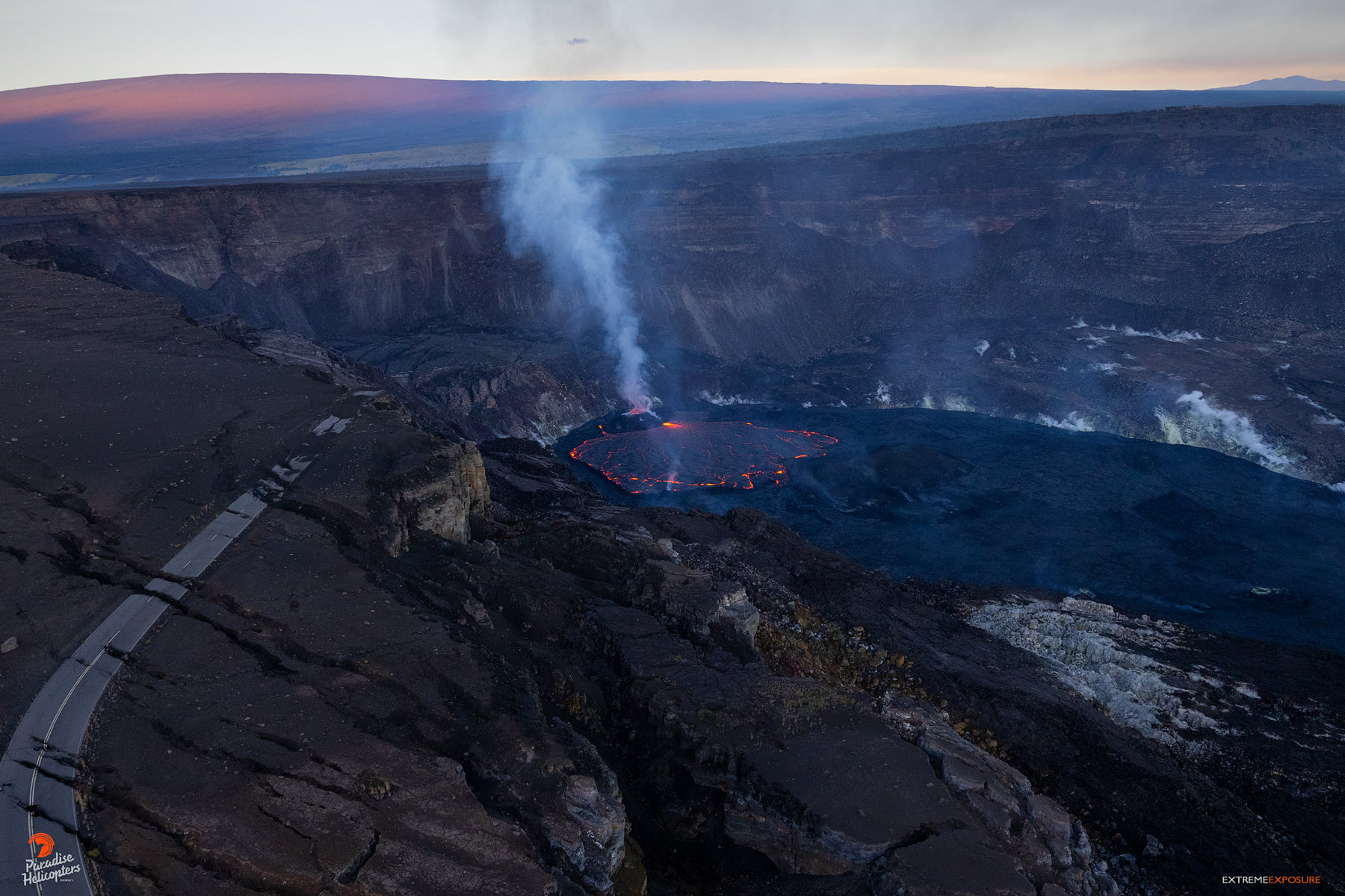
Summit Observations:
Sulfur dioxide (SO2) emission rates remain elevated, with an emission rate for November 23, 2021, of approximately 6400 tonnes per day. The average SO2 emission rate for recent weeks is approximately 3000 tonnes per day. Summit tiltmeters overall recorded net deflation over past day. Seismicity remains stable. Earthquake activity remains below background and volcanic tremor remains elevated since the beginning of the eruption.
Halemaʻumaʻu Lava Lake Observations:
Lava continues to erupt from a single vent in the western wall of Halemaʻumaʻu crater, while the eastern edge of the lake continues to advance onto the lowest of the exposed down-dropped caldera floor blocks. The western end of the lake showed a maximum elevation of approximately 808 meters (2651 ft) above sea level by HVO’s permanent laser rangefinder this morning, and a total increase of over 65 meters (213 ft) since lava emerged on September 29. Webcams show spatter and ponded lava within the west vent, an area of active lava at the surface of the lava lake, and sporadic oozes of lava along the cooler outer lake margins. The total erupted volume since the beginning of the eruption was estimated to be about 30 million cubic meters (7.8 billion gallons) on November 16.
Source : HVO
Photo : Bruce Omori .