October 15 , 2021.
Spain / La Palma , Cumbre Vieja :
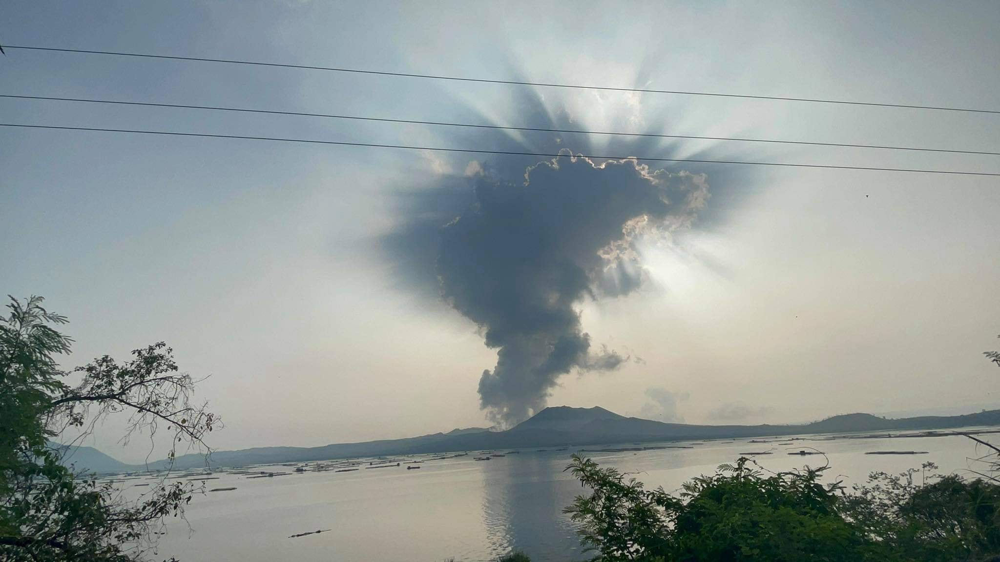
October 14, 2021 09:00 UTC: Eruptive activity continues on La Palma.
Since the last declaration, 102 earthquakes have been located in the area affected by the volcanic reactivation of Cumbre Vieja, 7 of these earthquakes were felt by the population, the maximum intensity being in the epicentral zone III-IV ( EMS98), with an event that occurred at 14:33 UTC on the 13th, with a magnitude of 4.4 (mbLg) at a depth of 36 km, which was felt throughout the island.
The largest localized earthquake occurred at 1:27 am today, with a value of 4.5 mbLg at a depth of 37 km. 14 of the earthquakes located since the last communication are located at depths of about 30 km, the rest of the hypocenters are located at a lesser depth, at about 10 km.
The volcanic tremor signal maintains a high average amplitude, without intensifying pulses since the last communication.
The height of the eruptive column measured at 6.30 UTC is estimated at 2,600 m.
The island’s network of permanent GNSS stations shows south-southwest uplift and deformation at station LP03, which is closest to the eruptive centers.
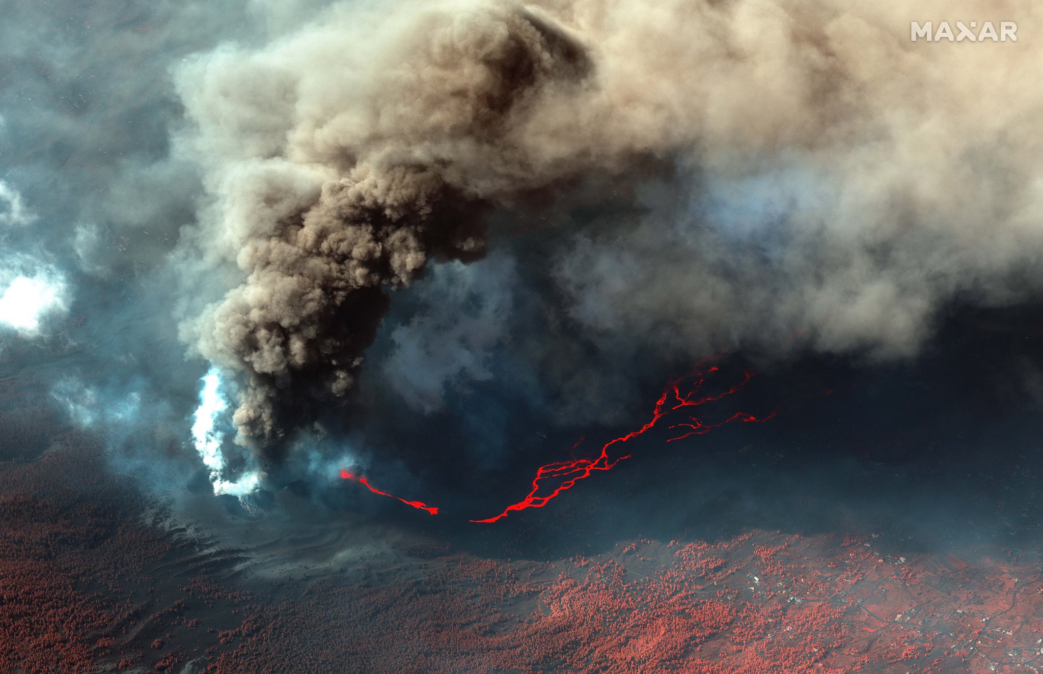
“There is a primary flow that has two branches south of the Todoque mountain. One has become a lava delta. And another more to the south that did not end up in the sea. In turn, the flow primary has an arm north of the Todoque mountain which also aborted its arrival at sea. These are the three main arms of the original flow « , said the technical director of the Volcanic Emergency Plan of the Canary Islands (Pevolca) , Miguel Ángel Morcuende.
“Above the primary flow there is another flow that is moving in a west-northwest direction on which there are two appendages. One that has had a high intensity and a lot of movement up to yesterday, it was the flow that destroyed the Spar [supermarket] in La Laguna tonight, and to the northwest of it is the other flow arm that crossed the Callejón de La industrial park diagonally. Gata, slipped from heights and crossed the La Laguna football pitch tonight. This is the cause of the latest deportations in La Laguna. » In the areas evacuated this Wednesday afternoon live 100 people and for this Thursday, 300. But it is possible that the evacuees are fewer because there are people who left their homes earlier.
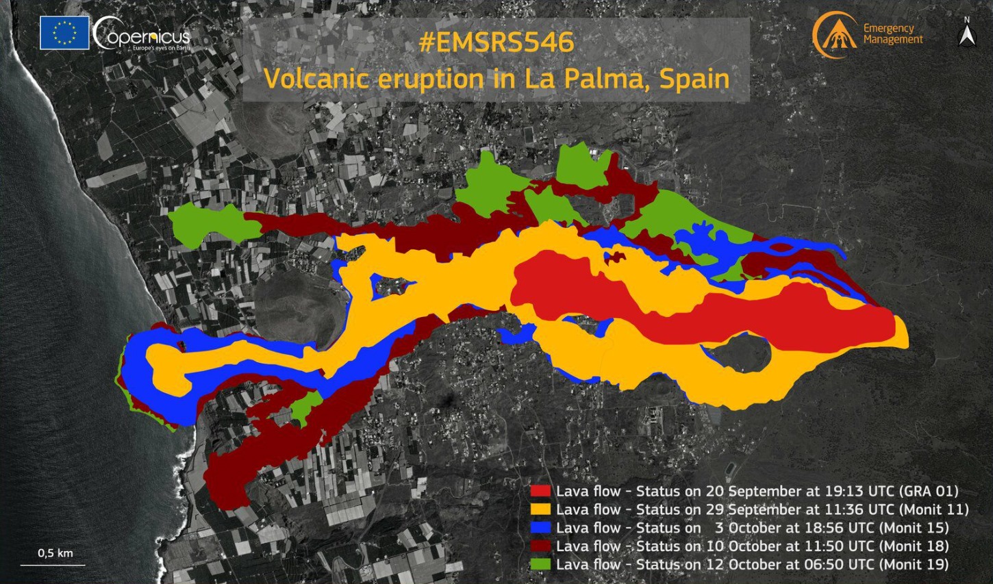
Lava from the Cumbre Vieja volcano overflowed from the main cone this Thursday at 2.15 p.m. (local time), as reported by Involcan (Instituto Volcanológico de Canarias). It remains to be seen what consequences this event may have on the flow of lava flows.
Sources : IGN es, El Pais.
Photos : maxar via Nadin Hubrich , Dominic Blaser.
Carte : Copernicus
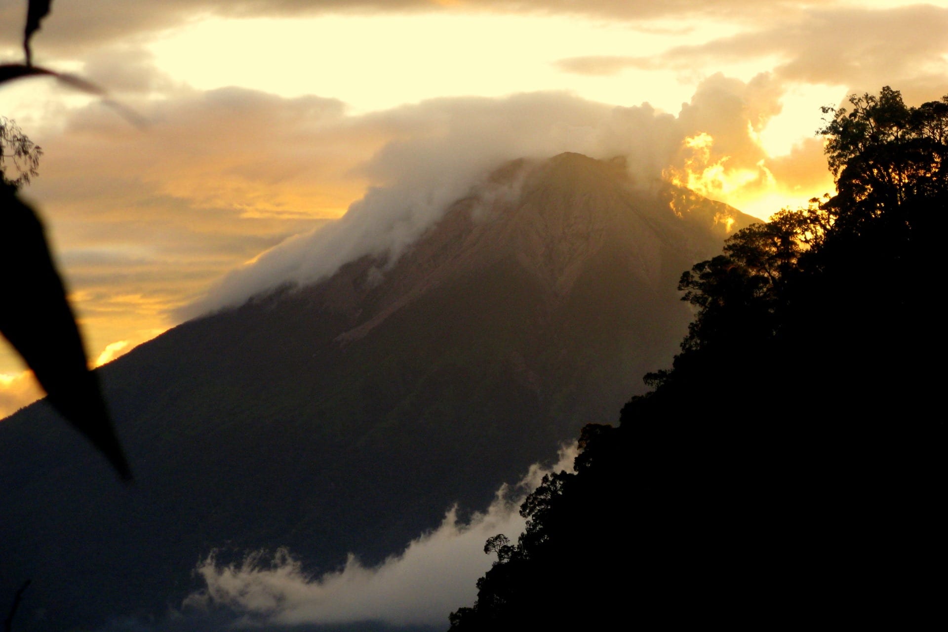
Iceland , Reykjanes Peninsula :
OCTOBER 14, 2021: Fewer earthquakes close to Keilir, no eruption in Fagradalsfjall mountain for almost one month
Earthquake activity continues close to Keilir mountain. But it remains at depth of 5 to 6 km and doesn’t show any sign that it is about to move to the surface. More than 10000 earthquakes have been recorded and 18 earthquakes have been recorded with magnitude above Mw3,0 according to Icelandic Met Office.
The eruption in Fagradalsfjall mountain has not been active since 19-September-2021 and there are no signs that the eruption is about to restart soon. Global Volcanism Program no longer updates its information for this volcano as an active eruption. Icelandic scientists in eruptions have not declared the eruption over. It should be expected that the eruption in Fagradalsfjall mountain is over for now, but it can start again at the same location or at new location in few weeks time or maybe even few years from now.
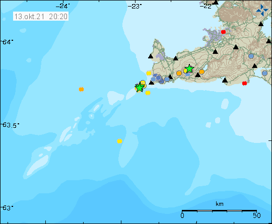
OCTOBER 13, 2021 : Earthquake swarm in Reykjanes volcano
On 12-October-2021, an earthquake swarm took place in Reykjanes volcano. Largest earthquake in this swarm had a magnitude of Mw3,3 and the earthquake swarm was out in the ocean not far from the coastline.
It is impossible to know for sure if this earthquake activity is directly connected to magma movements in this area. It is possible, but there have been some sign of magma moving in the crust in this area. The magma is moving but is not erupting or starting an eruption. Earthquake activity seems to be growing in this area of Reykjanes peninsula and Reykjanes ridge after the eruption in Fagradalsfjall mountain stopped.
The Reykjanes volcanic system at the SW tip of the Reykjanes Peninsula, where the Mid-Atlantic Ridge rises above sea level, comprises a broad area of postglacial basaltic crater rows and small shield volcanoes. The submarine Reykjaneshryggur volcanic system is contiguous with and is considered part of the Reykjanes volcanic system, which is the westernmost of a series of four closely-spaced en-echelon fissure systems that extend diagonally across the Reykjanes Peninsula. Most of the subaerial part of the system (also known as the Reykjanes/Svartsengi volcanic system) is covered by Holocene lavas. Subaerial eruptions have occurred in historical time during the 13th century at several locations on the NE-SW-trending fissure system, and numerous submarine eruptions dating back to the 12th century have been observed during historical time, some of which have formed ephemeral islands. Basaltic rocks of probable Holocene age have been recovered during dredging operations, and tephra deposits from earlier Holocene eruptions are preserved on the nearby Reykjanes Peninsula.
Source : icelandgeology.net , GVP.
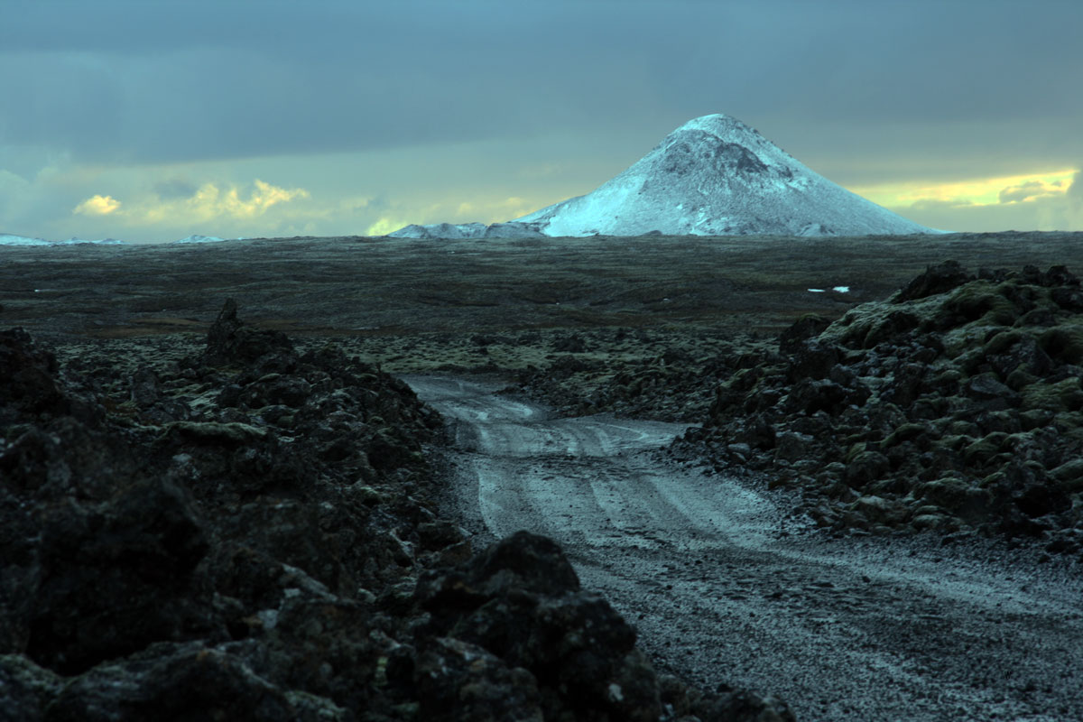
Photo : Wikipedia
Carte : IMO.
Hawaii , Kilauea :
19°25’16 » N 155°17’13 » W,
Summit Elevation 4091 ft (1247 m)
Current Volcano Alert Level: WATCH
Current Aviation Color Code: ORANGE
Activity Summary:
Kīlauea volcano is erupting. As of this morning, October 14, 2021, lava continues to erupt from a single vent in the western wall of Halemaʻumaʻu crater. All lava activity is confined within Halemaʻumaʻu crater in Hawai‘i Volcanoes National Park. Seismicity and volcanic gas emission rates remain elevated.
Summit Observations:
Sulfur dioxide (SO2) emission rates remain high, with a measured emission rate of approximately 4,400 tonnes per day on October 13, 2021, slightly lower than the previous day. Summit tilt was inflationary yesterday, October 13, becoming flat overnight.
Halemaʻumaʻu Lava Lake Observations:
Lava continues to erupt from a single vent in the western wall of Halemaʻumaʻu crater. The western end of the lake showed a maximum elevation of approximately 785 meters (2575 ft) above sea level when measured by field crews on October 13, with a total increase of about 42 meters (138 ft) since lava emerged on September 29. The total erupted volume since the beginning of the eruption was estimated to be about 15.9 million cubic meters (4.2 billion gallons) on October 8. The western vent had intermittent fountain heights of 5 m (16 ft) with occasional bursts up to 10 meters (33 ft) observed by field crews on October 13.
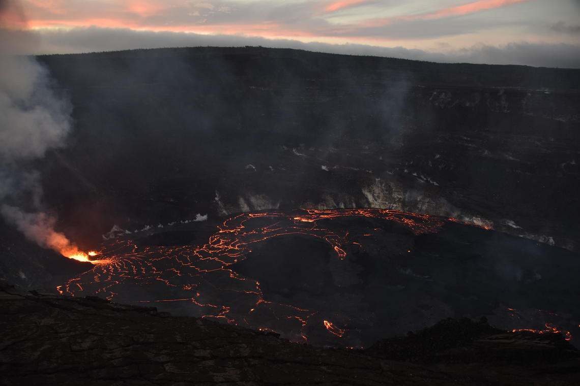
A wide view of the ongoing eruption at Kīlauea summit, from the south rim of Halema‘uma‘u. A vent on the western crater wall (left) continues to supply lava to the active west half of the lava lake. The west side of the lake is perched above the stagnant eastern (right) lake surface, with several lava overflows advancing over the previously solidified surface crust.
The fountain has built a spatter cone with an approximately 10 meter (33 ft) wide opening facing east towards the lake. Lava is flowing into the lake through the spatter cone opening. The central island and several of the smaller eastern islets from the 2020 lava lake are still above the lake surface along with an island of the 2020 western vent rampart in the northwest part of the lake. The lava lake is not level across its surface due to the location of the vent in the western end. Areas closer to the vent are about 1-2 meters (3-7 ft) higher in elevation compared to the north and south part of the lake and 9 meters (30 ft) higher than the east end of the lava lake. Lava surface activity such as crustal foundering is seen on the western end of the lake and north and south of the central island but is no longer observed on the east end of the lake.
Source : HVO
Photo : USGS / B. Carr.
Philippines , Taal :
TAAL VOLCANO BULLETIN 15 October 2021 8:00 AM
In the past 24-hour period, the Taal Volcano Network recorded thirty-eight (38) volcanic earthquakes, including thirty-seven (37) volcanic tremor events having duration of two (2) to five (5) minutes and a low-level background tremor that has persisted since 7 July 2021. Activity at the Main Crater was dominated by upwelling of hot volcanic fluids in its lake which generated plumes 1500 meters tall that drifted east.
Sulfur dioxide (SO2) emission averaged 6,893 tonnes/day on 14 October 2021. Based on ground deformation parameters from electronic tilt, continuous GPS and InSAR monitoring, Taal Volcano Island has begun inflating in August 2021 while the Taal region continues to undergo very slow extension since 2020.
Alert Level 2 (Increased Unrest) prevails over Taal Volcano.
Source : Phivolcs
Photo : Seys Marasigan / Seys Channel
Indonesia , Kerinci :
VOLCANO OBSERVATORY NOTICE FOR AVIATION – VONA
Issued : October 14 , 2021
Volcano : Kerinci (261170)
Current Aviation Colour Code : YELLOW
Previous Aviation Colour Code : yellow
Source : Kerinci Volcano Observatory
Notice Number : 2021KER06
Volcano Location : S 01 deg 41 min 49 sec E 101 deg 15 min 50 sec
Area : Jambi, West Sumatra, Indonesia
Summit Elevation : 12176 FT (3805 M)
Volcanic Activity Summary :
Gas emission at 10.h51 UTC (17h30 Lokal)
Volcanic Cloud Height :
Best estimate of ash-cloud top is around 14576 FT (4555 M) above sea level, may be higher than what can be observed clearly. Source of height data: ground observer.
Other Volcanic Cloud Information :
Volcanic plume moving to East
Remarks :
Seismicity activity is characterized by gas emission
Level of activity at level II (WASPADA) since September 9, 2007. The Kerinci volcano (3805 m above sea level) erupts intermittently.
The volcano is covered in fog. There is smoke from the crater, white, observable with low intensity and low pressure about 150 meters above the summit. The weather is sunny / cloudy with light to moderate winds from the northeast and east. The air temperature is around 16-27 ° C.
According to the seismographs of October 14, 2021, it was recorded:
134 emission earthquakes
1 deep volcanic earthquake
Sources : Magma Indonésie , PVMBG.
Photo : Wild Sumatra
Mexico , Popocatepetl :
October 14, 11:00 a.m. (October 14, 4:00 p.m. GMT)
During the last 24 hours, according to the monitoring systems of the Popocatepetl volcano, 117 exhalations accompanied by volcanic gases and light amounts of ash have been identified. 40 minutes of low and medium amplitude tremor were also recorded. In addition, two volcano-tectonic earthquakes were recorded yesterday at 12:32 and 21:12, with magnitudes of 2.6 and 1.8, respectively.
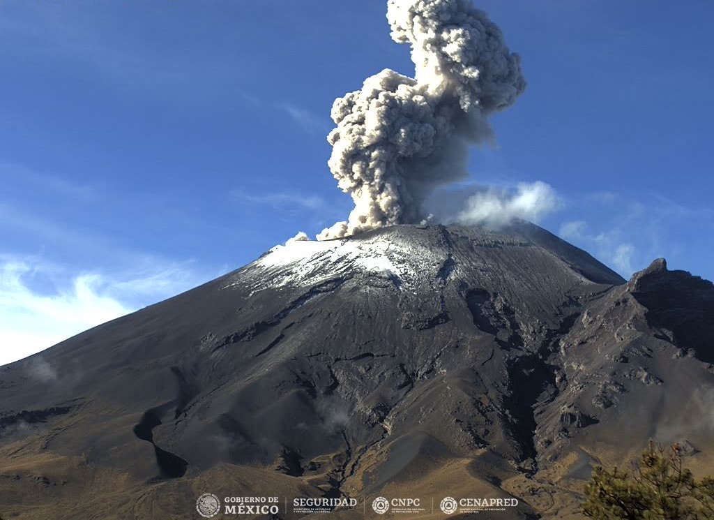
During the morning and at the time of this report, a slight emission of water vapor and volcanic gases is observed with a westerly direction.
CENAPRED recommends NOT TO APPROACH the volcano and especially the crater, because of the danger of falling ballistic fragments and, in the event of heavy rains, to stay away from the bottom of the ravines because of the danger. mudslides and debris.
The Popocatépetl volcanic traffic light is in PHASE 2 YELLOW.
Source et photo : Cenapred .