September 21 , 2021.
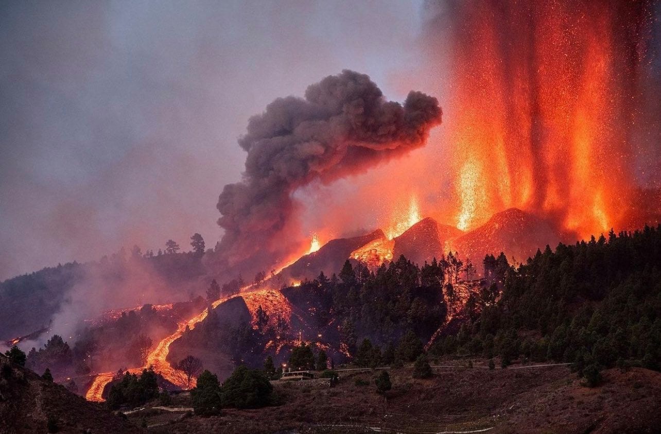
Spain / La Palma , Cumbre Vieja :
The eruption in La Palma has enough material, intensity and magma to last for weeks «
The director of the Central Geophysical Observatory of the National Geographic Institute, Carmen Lopez, says it is still early to know exactly how long the lava emission will last. « There have been a few small earthquakes and the unstoppable eruption has followed. The lava flows are descending and the activity is intense. There are already nine emission points in the two fractures. The eruption is in progress. for a very short time it is still early to see the evolution. » It is not excluded that other emission points or other small fractures may emerge.
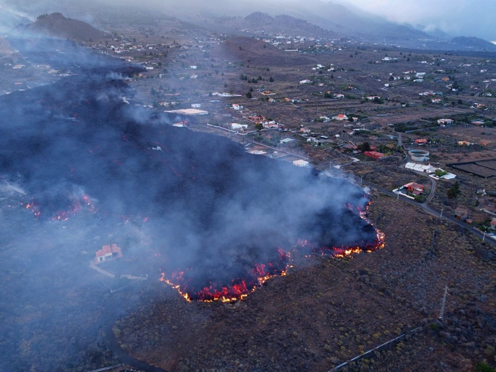
The volcanic eruption that started on the island of La Palma in the Canaries remained active overnight. In this period, its intensity has fortunately decreased slightly, despite this, the main lava flow fed by one of the two eruptive fractures has already crushed and destroyed about a hundred public and private buildings.
The speed at which this flow is advancing has increased from 700 meters last night to 300 hours this morning.
In recent hours, the Canary Islands Volcanological Institute has been carrying out a series of aerial overflights to try to sample and analyze both the emission of sulfur dioxide (SO2), a gas that is particularly irritating to us humans, and to acquire new thermal images. of the entire eruptive zone atmosphere.
In recent hours, local authorities have said that if the speed at which the flow is moving remains constant throughout the day, it will reach the coastal area around 8 p.m. tonight.
The Santa Cruz de Tenerife harbor master’s office has temporarily banned navigation in the area affected by the volcanic eruption on the island of La Palma. This is a preventive measure for the risk to navigation, in the face of the possible arrival of volcanic flows at sea, indicated the general direction of the merchant marine of the ministry of transport, mobility and the urban agenda. (Mitma).
The 47-km-long wedge-shaped island of La Palma, the NW-most of the Canary Islands, is composed of two large volcanic centers. The older northern one is cut by the massive steep-walled Caldera Taburiente, one of several massive collapse scarps produced by edifice failure to the SW. The younger Cumbre Vieja, the southern volcano, is one of the most active in the Canaries. The elongated volcano dates back to about 125,000 years ago and is oriented N-S.
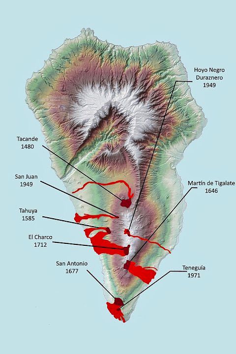
Eruptions during the past 7,000 years have formed abundant cinder cones and craters along the axis of Cumbre Vieja, producing fissure-fed lava flows that descend steeply to the sea. Eruptions recorded since the 15th century have produced mild explosive activity and lava flows that damaged populated areas. The southern tip of the island is mantled by a broad lava field emplaced during the 1677-1678 eruption. Lava flows also reached the sea in 1585, 1646, 1712, 1949, and 1971.
Update of information on the emission of sulfur dioxide (SO2) into the atmosphere by the new volcanic eruption of Cumbre Vieja.
Yesterday, Monday September 20, 2021, the Canary Islands Volcanic Institute (INVOLCAN) carried out new measurements to assess and monitor the amount of sulfur dioxide (SO2) released into the atmosphere by the current eruptive process of Cumbre Vieja.
The results obtained for this second day of eruption reflect an SO2 emission rate of between 7,997 and 10,665 tonnes per day, assuming that the wind speed at 3,000 meters yesterday was between 4.2 and 5, 5 meters per second (meteorological data provided by AEMET).
The estimate was made after carrying out several measurement transects with a remote optical sensor, miniDOAS type, both in zone mobile position (with the instrumentation mounted on one of the helicopters of the Civil Guard of Tenerife ) and in land mobile position (with the miniDOAS mounted on one of the ITER / INVOLCAN vehicles).

The values obtained during the second day of this eruption process (7,997-10,665 tons per day) are similar and even slightly higher than the values recorded for the first day of the eruption (6,000 – 9,000 tons per day). These results are consistent with the first 48 hours of evolution of this eruptive process with the appearance of a new point of emission of magmatic matter in Tacande, an area of the municipality of El Paso (La Palma).
The SO2 emission results obtained by ground observations are consistent with satellite observations recorded by TROPOMI, the satellite instrument on board the Copernicus Sentinel-5 Precursor satellite.
Sources : El Pais , Il Mondo dei Terremoti , GVP. Involcan.
Photos : Abian San Gila , Auteur inconnu , volcanes de Canarias. ATHOS Centro Astronómico La Palma .
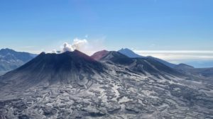
Peru , Sabancaya :
Analysis period: September 13, 2021 to September 19, 2021, Arequipa, September 20, 2021.
Alert level: ORANGE
The Geophysical Institute of Peru (IGP) reports that the eruptive activity of the Sabancaya volcano remains at moderate levels, that is to say with the recording of an average of 26 daily explosions, with columns of ash and gas up to 3.3 km altitude above the summit of the volcano and their consequent dispersion. Therefore, for the following days, no significant change is expected in eruptive activity.

The IGP recorded and analyzed the occurrence of 689 earthquakes of volcanic origin, associated with the circulation of magmatic fluids within the Sabancaya volcano. An average of 26 explosions was recorded daily. During this period, Volcano-Tectonic (VT) earthquakes associated with rock fractures were located mainly in the North-East and East of Sabancaya and presented magnitudes between M2.0 and M4 , 1.
The monitoring of the deformation of the volcanic structure using GNSS techniques (processed with fast orbits) does not present any significant anomalies. However, in general, an inflation process was observed in the northern sector (around the Hualca Hualca volcano). Visual surveillance made it possible to identify columns of gas and ash up to 3.3 km altitude above the summit of the volcano, which were scattered towards the South, South-East, East, West, South sectors – West and North-East of Sabancaya. Satellite recordings have identified the presence of 4 thermal anomalies (maximum value of 13 MW) associated with the presence of a lava body on the surface of the volcano’s crater.
RECOMMENDATIONS
• Keep the volcanic alert level in orange.
• Do not approach within a radius of 12 km from the crater.
Source : IGP.
Photo : Zintia Roxana Fernández Licla.
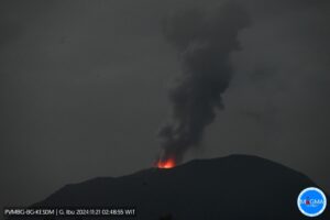
Alaska , Semisopochnoi :
VOLCANO OBSERVATORY NOTICE FOR AVIATION (VONA)
Issued: September 21 , 2021
Volcano: Semisopochnoi (VNUM #311060)
Current Color Code: ORANGE
Previous Color Code: RED
Source: Alaska Volcano Observatory
Notice Number: 2021/A817
Volcano Location: N 51 deg 55 min E 179 deg 35 min
Area: Aleutians
Summit Elevation: 2625 ft (800 m)
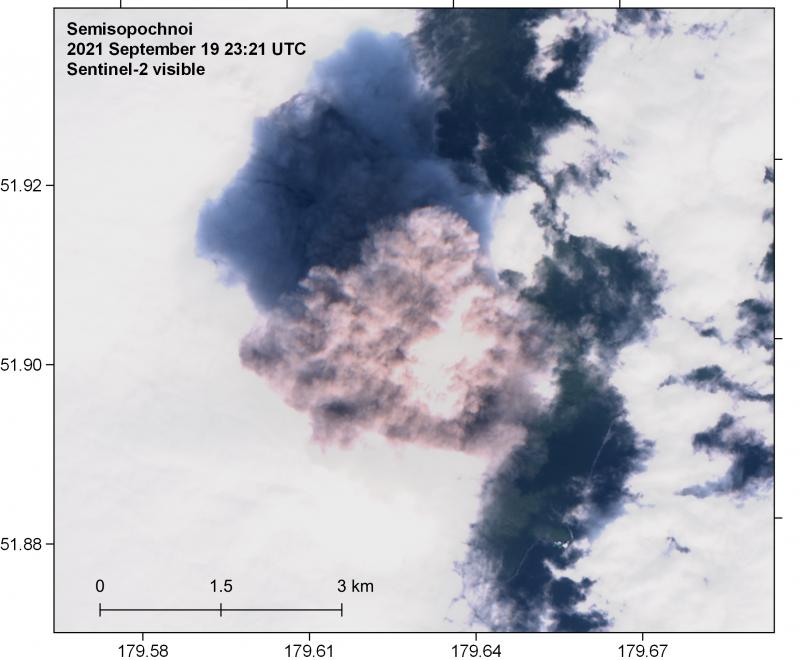
Noon September 19 (23:21 9/19 UTC) Visible image from Sentinel-2 satellite over Semisopochnoi showing an ash plume rising above the weather cloud ceiling of approximately 5,000 feet.
Volcanic Activity Summary:
Ash emissions from the ongoing eruption at Semisopochnoi continue at a decreased rate. Over the last few hours, activity has consisted of discrete explosions that occur about once an hour and produce small ash clouds that rise to 10,000 to 15,000 feet above sea level and are currently drifting to the northwest. This represents less significant ash emissions and we are therefore lowering the Aviation Color Code and Volcano Alert Level to ORANGE/WATCH.
Activity at Semisopochnoi remains elevated and ash emissions could increase again at any time.
Volcanic cloud height:
10,000 to 15,000 ft. asl
Other volcanic cloud information:
Small ash clouds are drifting NW
Remarks:
Semisopochnoi is monitored by a local seismic and infrasound network, local web cameras, regional lightning and infrasound sensors, and satellite data.
Source : AVO.
Photo : Loewen, Matt.
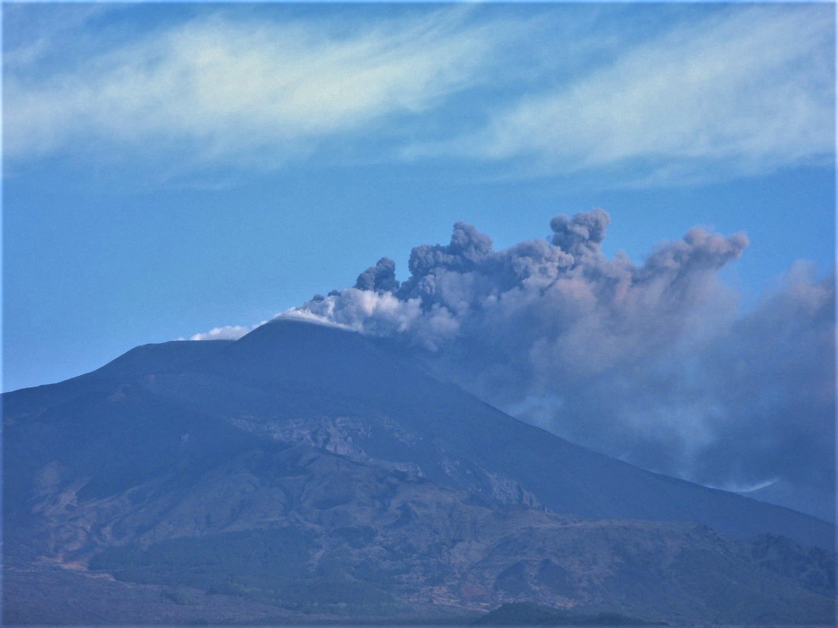
Italy / Sicily , Etna :
COMMUNICATION ON THE ACTIVITY OF ETNA, September 21, 2021, 05:35 (03:35 UTC).
The National Institute of Geophysics and Volcanology, Osservatorio Etneo, announces that the average amplitude of the volcanic tremor, after a first gradual increase that started with large fluctuations a few hours earlier, from 02:20 UTC today showed a sudden increase and at around 02:40 UTC reached the high range.
The center of gravity of volcanic tremor sources is located in the area of the Southeast Crater at an altitude of about 2900 m above sea level. The infrasound activity, at present, remains at low levels. The images from the CCTV cameras do not show any eruptive activity in progress.
COMMUNICATION ON THE ACTIVITY OF ETNA, September 21, 2021, 09:17 (07:17 UTC).
The National Institute of Geophysics and Volcanology, Osservatorio Etneo, announces that as of approximately 6:15 UTC, images from CCTV cameras show ash emissions from the Southeast Crater. At 6:55 UTC we observe the resumption of Strombolian activity at the level of the Southeast Crater. The eruptive cloud produced by the current activity reaches a height of about 4500 m and, according to the forecast model, disperses in an East-North-East direction.
The increase in the mean amplitude of the volcanic tremor continues with a further increasing trend. The center of gravity of the volcanic tremor sources is located in the area of the Southeast Crater at an altitude of about 2900-3000 m above sea level. From 06:55 UTC, at the same time as the resumption strombolian activity, the start of infrasound activity is recorded
Further updates will be communicated shortly.
Source : INGV.
Photo : Boris Behncke .
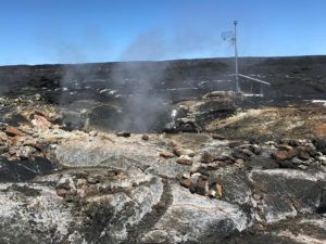
La Martinique , Mount Pelée :
Weekly report on the activity of Mount Pelée for the period from September 10 to September 17, 2021.
Between September 10, 2021 at 4 p.m. (UTC) and September 17, 2021 at 4 p.m. (UTC), OVSM recorded at least 54 volcano-tectonic earthquakes of magnitude less than or equal to 0.4. These earthquakes were located inside the volcanic edifice between sea level and 0.5 km above sea level. None of these earthquakes were felt by the population. This volcano-tectonic-type superficial seismicity is associated with the formation of micro-fractures in the volcanic edifice.
A degassing zone at sea was detected at shallow depth (between St Pierre and le Prêcheur). The IGP is currently setting up experiments to map this gas emanation zone, carry out physicochemical measurements of the fluids and samples of these fluids in order to understand the origin of this degassing and to assess its possible relationship. with the hydrothermal system of Mount Pelée. This kind of manifestation is frequent on active or not active underwater volcanic sites. The analyzes underway by the OVSM-IPGP will make it possible to determine the possible relationship of this underwater degassing with the activity of Mount Pelée recorded by the OVSM since 2019.
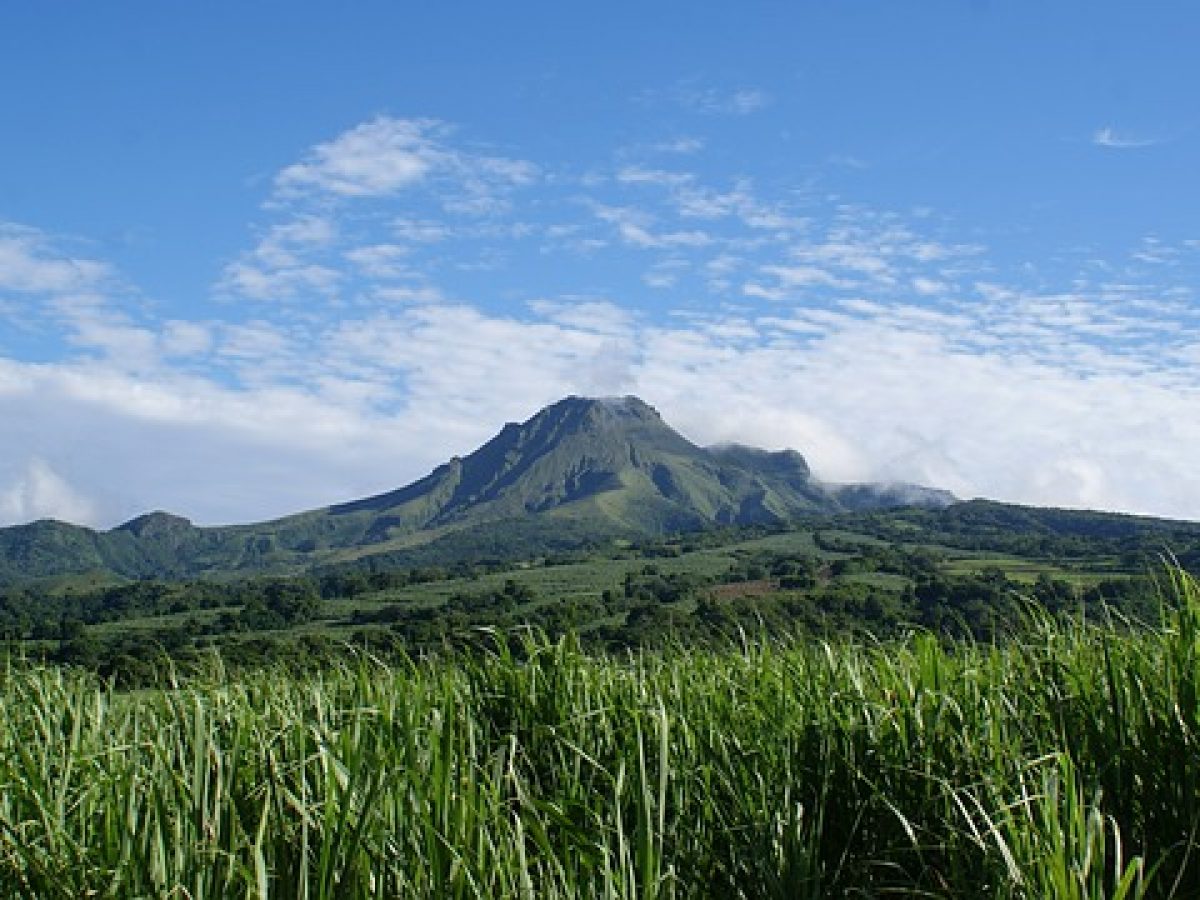
A main area of heavily degraded vegetation is still observed on the southwest flank of Mount Pelée, between the upper Claire River and the Chaude River.
The alert level remains YELLOW: vigilance.
An earthquake of magnitude 3.9 was recorded on Monday, September 20, 2021 at 17:23 (local time) and identified of Tectonic origin. The epicenter was located 33 km northeast of Le Vauclin, at a depth of 28 km (i.e. a hypocentral distance of about 43 km). This earthquake was able to generate, in the closest affected areas, an average acceleration of the ground of 1.7 mg, corresponding to a macroseismic intensity II (rarely felt). Depending on the type of soil, however, intensities may have locally reached intensity III − IV (widely felt).
Source : Direction de l’OVSM IPGP.
Photo : Antilles prestige