September 08 , 2021.
Italy , Stromboli :
Weekly bulletin from August 30, 2021 to September 05, 2021 (issue date September 07, 2021)
SUMMARY STATEMENT OF ACTIVITY
In view of the monitoring data, it is highlighted:
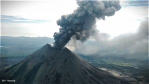
1) VOLCANOLOGICAL OBSERVATIONS: During this period a normal explosive activity of strombolian type was observed. The total hourly frequency of explosions fluctuated between medium-low and medium values (9-13 events / h). The intensity of the explosions was mainly medium to low both in the North crater area and in the Center-South area.
2) SEISMOLOGY: The seismological parameters monitored do not show significant variations.
3) DEFORMATIONS: The island’s soil deformation monitoring networks have shown no significant changes over the past week.
4) GEOCHEMISTRY: SO2 flux at medium-low level
The flow of CO2 from the ground to the Pizzo Sopra la Fossa shows an increase but still within the range of average values.
The weekly average C / S ratio is at average values (C / S = 9.24).
The isotopic ratio of Helium dissolved in the thermal aquifer (latest data from 08/19/2021) was at medium – high values.
5) SATELLITE OBSERVATIONS: The thermal activity in the summit area is at a low level.
VOLCANOLOGICAL REMARKS
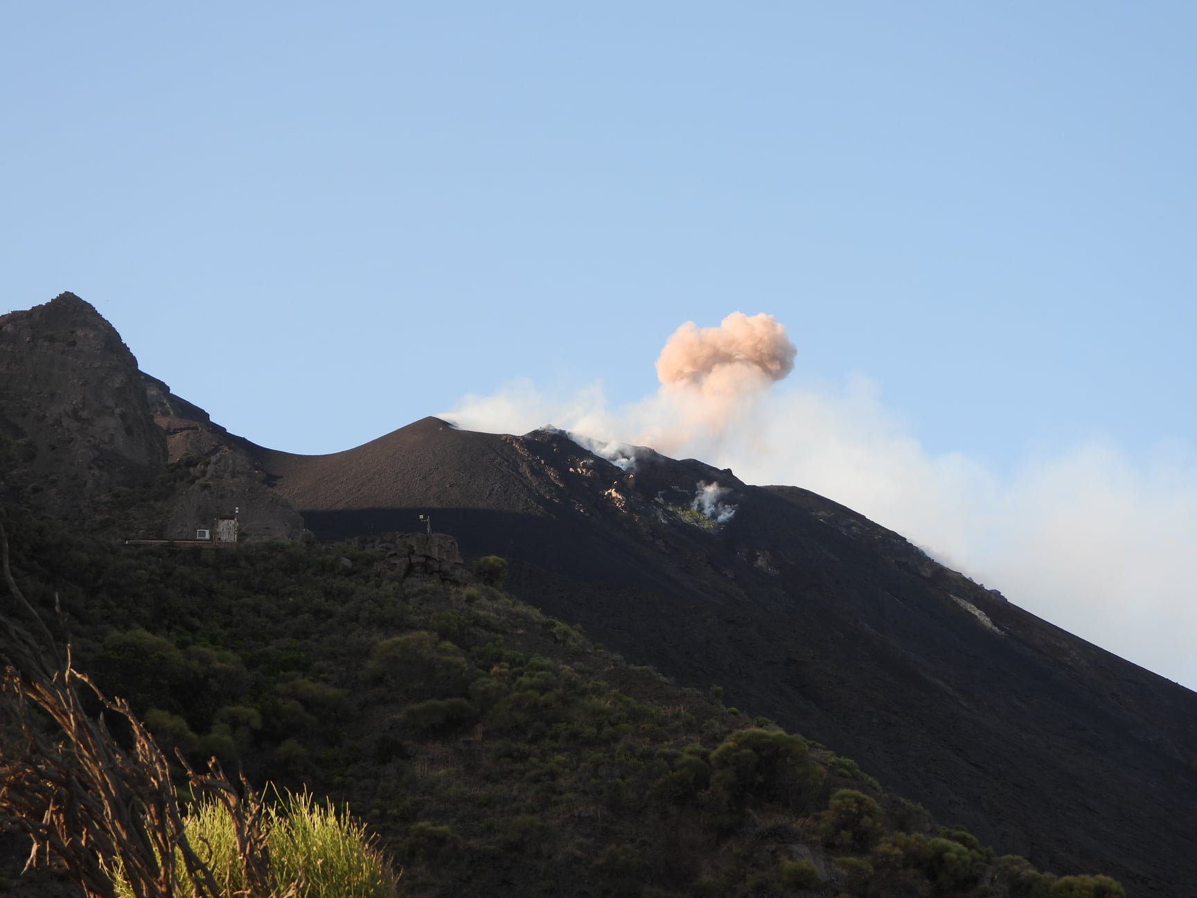
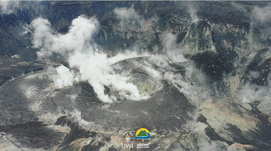
During the observation period, the eruptive activity of Stromboli was characterized by an inspection in the summit area carried out by INGV staff and by the analysis of the images recorded by the surveillance cameras INGV-OE ( altitude 190, Punta Corvi, altitude 400 and Pizzo Sopra la Fossa). The explosive activity was mainly produced by 3 (three) eruptive chimneys located in the North crater area and by 6 (six) eruptive chimneys located in the Center-South crater area. All the vents are placed inside the depression which occupies the terrace of the crater (Fig. 3.1).
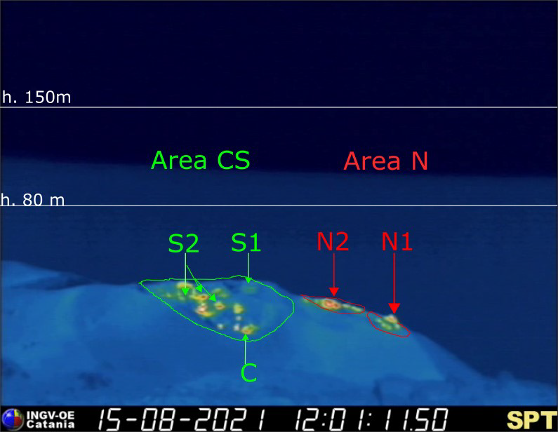
Fig. 3.1 – The crater terrace seen by the thermal camera placed on Pizzo Sopra la Fossa with the delimitation of the zones of the crater Center-South Zone and North Zone (ZONE N, ZONE C-S respectively).
On the morning of September 2, 2021, INGV staff carried out a survey in the summit area to define the morphological changes and the eruptive style of the mouths in the crater area. During the inspection, it was observed that in the North zone, the N1 sector presented a cone with two vents and a hornito inside (not active these days) and also 3 other vents on the Sciara side . The explosive activity, mainly consisting of ashy material, showed a low frequency of occurrence of events and a medium-low intensity of low frequency and intensity. Sector N2 with the presence of at least 2 vents produced explosions of coarse materials mixed with ash with very low frequency (less than one event / h) with medium intensity. In the center-south zone, sector C had 3 vents, 2 of which were degassing but without any type of explosive activity, sector S1 formed by a structured cone, did not display any activity. Finally, sector S2 presented 2 degassing vents, a partially demolished hornito and an intracrateric depression (along a North-West-South-East line) with Strombolian activity emitting coarse materials mixed with ash. The frequency of the explosions was medium-low (between 5 and 10 events / h) while the intensity was medium (the products did not exceed 150 m in height). It is interesting to note that there is another cone facing the Sciara del fuoco.
Overall during the week the N1 crater located in the North zone, with two emission points, produced low intensity explosions (less than 80 m in height) emitting fine materials (ash) sometimes mixed with coarse materials (lapilli and bombs) until September 3. On September 4 and 5, a constant increase in the coarse component until it becomes preponderant characterizes the explosions of the last day of the observation period. Vent N2 showed low intensity explosive activity (less than 80 m in height) emitting fine material sometimes mixed with coarse material. The average frequency of explosions varied from 3 to 5 events / h.
In the Center-South zone, sector S1 did not produce explosive activity while the three vents located in sector S2 produced explosions, even simultaneously, of medium and low intensity (the products of certain explosions have reaches 150 m in height) emitting mostly coarse matter. Sector C produced degassing activities. The frequency of the explosions varied from 5 to 9 events / h.
Source : INGV.
Photo : Boris Behncke
Iceland , Skaftá River :
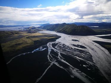
Flood of the Skafta
It can be estimated that only about 1/3 of the total volume of water has already reached Sveinstindur
Update September 07 at 9:40 a.m.
The flow at Eldvatn de la Skaftá has continued to increase since last night and now measures just over 520m3 / sec. Sveinstindur’s water level gauge now reads around 1,400 m3 / s if you take into account that a considerable amount of running water begins to flow past the gauge, as in previous passes. Growth has slowed down a lot since 11 p.m. yesterday. The development of the flood this evening indicates that the maximum flow will now be lower than that of 2015 and 2018. The maximum flow of 2018 was just over 2,000 m3 / sec.
The flood is still expected to peak on Route 1 tomorrow. It can be assumed that the gel distribution will increase in colonies for a day or more, after maximum flow has been reached at Eldvatn. Ice observations from the Institute of Earth Sciences indicate that the volume of water from boiler runoff will be larger than in 2018, so the impact of runoff on settlements could be similar to 2018 , despite the fact that the maximum flow can now be less. Additionally, runoff from the western boiler and recent rains mean the floodplain is saturated with water, which will likely increase the spread of runoff.
The flood is still expected to peak on Route 1 tomorrow. Ice measurements from the Icelandic Oceanographic Institute indicate that the volume of runoff from the eastern cauldron will be larger than in 2018, so the impact of runoff on the plains may be similar to 2018, despite the fact that the maximum flow can now be lower. Additionally, runoff from the West Cauldron and recent rains mean the floodplain is saturated with water, which will likely increase the spread of runoff.

Update 07 September at 15:40
The flooding of the Skaftá on Route 1 slowed down considerably on this day. Eldvatn’s water level gauge now displays a flow rate of over 560m3 / sec. The same goes for the flow at Sveinstindur, which continues to be measured just below 1,500 m3 / sec.
It is estimated that about 75 gigaliters of running water appeared in Sveinstindur during the first 24 hours of the flood. Measurements indicate that the total volume of the eastern cauldron was around 260 gigaliters before it ran out. It can therefore be estimated that only about 1/3 of the total volume of running water has already reached Sveinstindur.
The Skaftá in 2018. Photo of a surveillance flight on August 4, when the flow peaked in Sveinstindur. (Photo: Meteorological Office / Benedikt G. Ófeigsson)
The maximum flow at Sveinstindur is lower than that of the last emptying of the eastern cauldron, so we can assume that the current flood will last longer. A longer flood, combined with a high water level at the start, can lead to a greater diffusion of running water in built-up areas.
Source : Vedur is.
Photos : Eldfjalla- og náttúruvárhópur Suðurlands , Office météorologique / Benedikt G. Ófeigsson
Video : Eldfjalla- og náttúruvárhópur Suðurlands
Italy / Sicily , Etna :
Weekly bulletin from August 30, 2021 to September 05, 2021 (issue date September 07, 2021)
SUMMARY STATEMENT OF ACTIVITY.
In view of the monitoring data, it is highlighted:
1) VOLCANOLOGICAL OBSERVATIONS: Strombolian activity at the Southeast Crater; pulsed degassing of the Bocca Nuova crater and ordinary degassing of the Voragine and Northeast craters.
2) SEISMOLOGY: Weak seismic activity of fracturing; the amplitude of the volcanic tremor remained mainly at low levels.
3) INFRASONO: Low infrasound activity.
4) DEFORMATIONS: No significant change to report.
5) GEOCHEMISTRY: SO2 flux at medium level
HCl flow occurs at a medium-low level.
The flow of CO2 emitted by the soils shows a peak which culminates at 9 m.c. on medium-high values.
The partial pressure of CO2 dissolved in water does not show significant variations.
The helium isotope ratio appears on average to high values (latest data from 08/31/2021).
There are no updates for the C / S report.
6) SATELLITE OBSERVATIONS: The thermal activity in the summit area after the lava fountain of August 29, 2021 was at a low level.
VOLCANOLOGICAL REMARKS
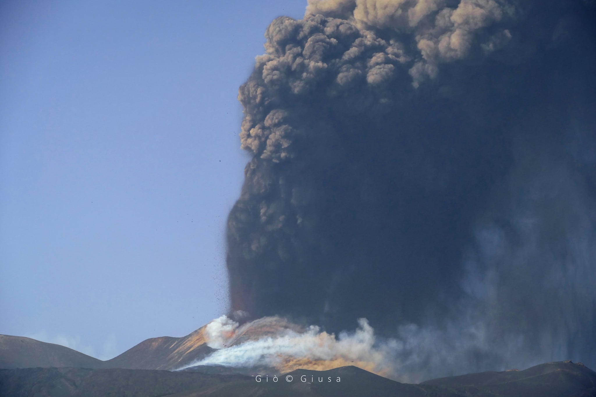
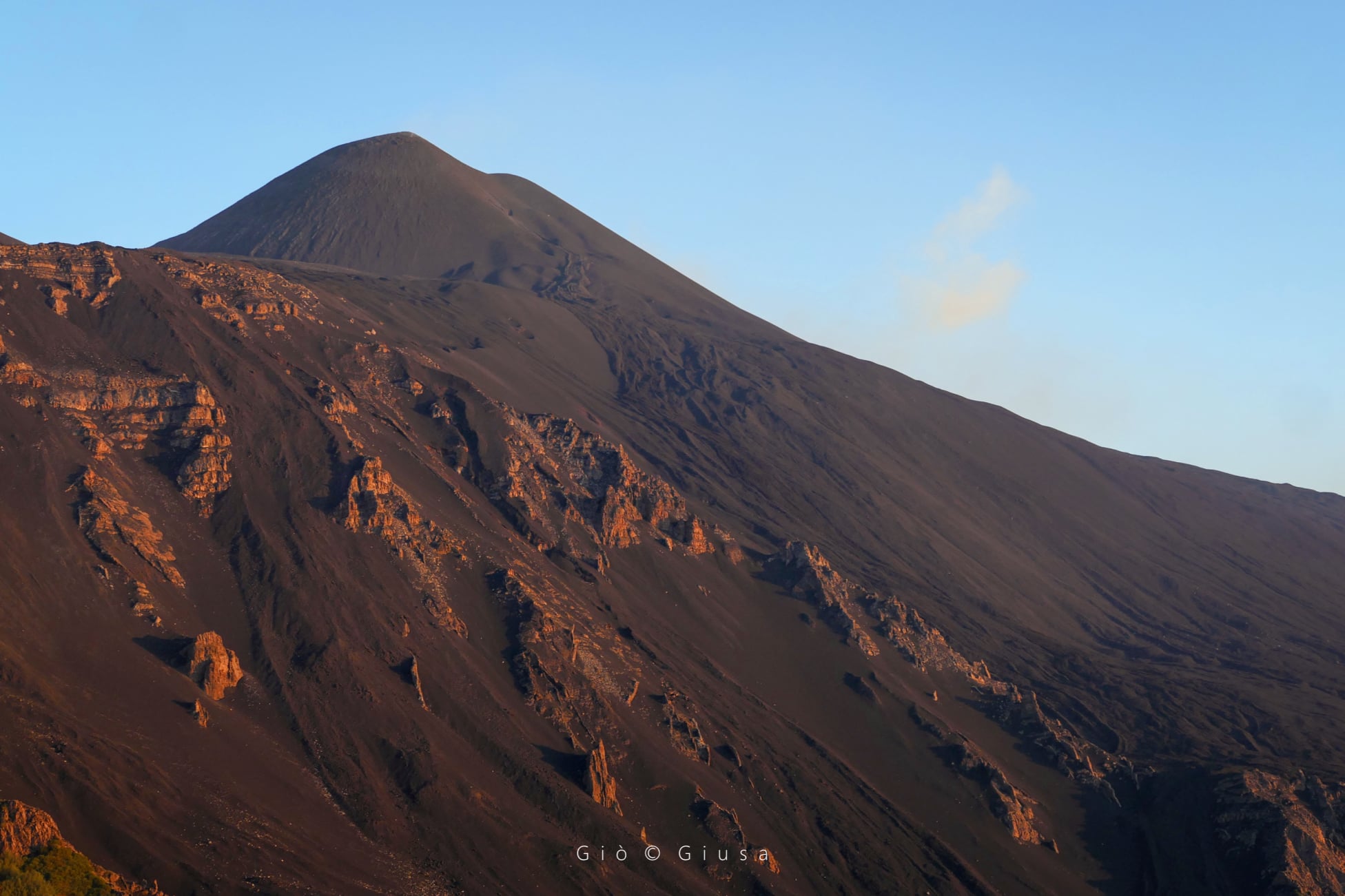
During the week, the monitoring of the volcanic activity of Etna was carried out by analyzing the images of the network of surveillance cameras of the INGV section of Catania, Osservatorio Etneo (INGV-OE). During the first days of the week, the activity at the level of the summit craters of Etna consisted of a usual degassing, which maintained the pulsatile character of the Crater of Bocca Nuova already observed for several weeks. In particular, on the 30th, starting around 8:30 p.m., the resumption of weak Strombolian activity was observed at the level of the Southeast Crater. This activity ended within 24 hours.
SEISMOLOGY
Seismicity: During the week in question, no earthquakes were recorded exceeding the threshold of magnitude 2.0.
Volcanic tremor: The temporal trend of the mean amplitude of the volcanic tremor remained at a low level throughout the week, except for large and sudden fluctuations, between medium-low values and medium-high values, linked to the appearance of low-frequency transient phenomena, associated with explosive activity at the level of the Southeast Crater, which occurred between the end of August 30 and the early hours of August 31. The location of the source of the tremor is located in the area between the Southeast Crater and Bocca Nuova, at a depth of about 1500-2900 meters above mean sea level.
Source : INGV.
Photos : Gio Giusa.
Saint Vincent , Soufrière Saint Vincent :
La Soufrière Volcano – SCIENTIFIC UPDATE 07/09/21 1:00PM
-Seismic activity at La Soufrière, St Vincent has remained low since the tremor associated with the explosion and ash venting on 22 April.
-Current activity is consistent with a period of unrest after an eruption. This can continue for weeks to months. While volcanic activity has been on a decline, there is the continued presence of near surface hot spots, daily seismic activity and persistent degassing.
– Lahar signals have been observed but at a lower rate.
– Work was completed to finalize the installation of the summit seismic station on September 01st through the assistance of the British helicopter RFA Wave Knight.
– The helicopter flight enabled excellent views of the crater and observations indicate no major changes have occurred in the crater since the end of explosive activity on 22 April.
– There is a small, but not insignificant, possibility that magmatic activity might restart, should there be an influx of new magma from depth.
– The volcano is at alert level ORANGE.
Source et photo : UWI.
Ecuador , Sangay :
DAILY REPORT ON THE STATE OF SANGAY VOLCANO.
Surface activity level: High, Surface trend: No change.
Internal activity level: High, Internal trend: No change.
Seismicity: From September 06, 2021, 11:00 to September 07, 2021, 11:00:
The reference seismic station remains operational, the seismic statistics are complete.
Explosion (EXP) 69
Long period (LP) 14
Tremors of emission (TREMI) 65
Lahars: 1
Emission column / ash:
No emissions were observed by the cameras, however, the VAAC recorded 1 ash emission alert observed by the satellites which reached 900 meters above the level of the crater in a southwest direction
Rains / Lahars:
Until around 8:00 p.m. TL. yesterday, high frequencies were recorded associated with the descent of mudslides and debris following the rainy episodes recorded in the area. ** In case of heavy rains, secondary lahars may be generated in the Volcán River, the Upano and other tributaries **
Other monitoring parameters:
No changes were recorded in other monitoring parameters, and no thermal alerts were recorded.
Observation:
The cloudiness was permanent in the area, preventing direct observation of surface activity.
Alert level: yellow.
Source : IGEPN.
Photo : H communication.
Hawaii , Kilauea :
19°25’16 » N 155°17’13 » W,
Summit Elevation 4091 ft (1247 m)
Current Volcano Alert Level: ADVISORY
Current Aviation Color Code: YELLOW
Activity Summary:
Kīlauea Volcano is not erupting. Following the recent intrusion of magma beneath the surface in the area south of Kīlauea caldera, which slowed substantially on August 30, earthquake rates and ground deformation in this area have remained near pre-intrusion levels. Other monitoring data streams, including sulfur dioxide emission rates and webcam views, show no significant changes.
Summit Observations:
Over the past week, 75 small-magnitude earthquakes—all below M2.5—were detected beneath the summit region of Kīlauea. Most of these earthquakes occurred approximately 1-4 kilometers (0.6-2.5 miles) below ground level in the area south of Kīlauea caldera, where the recent intrusion was focused, but this earthquake rate is a fraction of that from the previous week when 732 events were detected in the area. Since August 30, tiltmeters have not detected any substantial ground deformation in the summit region. These observations suggest that the supply of new magma to the intrusion has slowed or stopped.
Sulfur dioxide (SO2) emission rates remain at very low levels that have persisted since May 2021, when the most recent summit eruption ended. The latest SO2 emission rates—measured on September 2—were 115 tonnes per day, close to levels associated with the non-eruptive period from late 2018 to late 2020 (less than 50 tonnes per day). The present rates are significantly lower than the average of over 800 tonnes per day that prevailed from mid-February to mid-April when the Kīlauea summit eruption was ongoing.
Halemaʻumaʻu Lava Lake Observations:
The surface of Halema‘uma‘u lava lake, which was actively erupting from December 2020 through May 2021, remains covered by stagnant and solidified lava crust. Currently, there are no indications of the Halema‘uma‘u vent resuming eruption.
East Rift Zone Observations:
No unusual activity has been noted in the Kīlauea East Rift Zone. Ground deformation monitors indicate that the upper East Rift Zone—between the summit and Puʻuʻōʻō—is refilling at rates similar to those measured over the past 2 years and before the December 2020–May 2021 eruption in Halemaʻumaʻu. SO2 and hydrogen sulfide (H2S) emissions from Puʻuʻōʻō were below instrumental detection levels when last measured on January 7, 2021.
Source : HVO
Photo : USGS/ M. Zoeller.