June 24 , 2021.
Italy / Sicily , Etna :
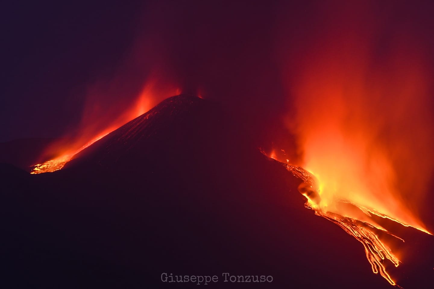
Two paroxysms during the day ….
Press release on ETNA activity, 23 June 2021, 03:16 (01:16 UTC).
The National Institute of Geophysics and Volcanology, Osservatorio Etneo announces that from 00:30 UTC it was possible to observe, from surveillance cameras, the resumption of Strombolian activity at the Southeast Crater from at least three eruptive vents. Based on the forecast model, the eruptive cloud produced by the current activity disperses eastward.
The amplitude of the volcanic tremor is on high values with an increasing tendency. The infrasound activity remains at a low level.
No significant change is observed in the distortion signals recorded on the inclinometric and GNSS networks.
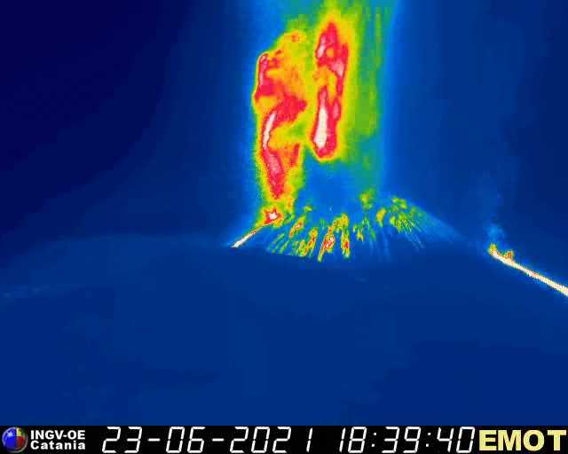
As of 02:13 UTC, there was also an overflow of lava from the Southeast Crater which extends in a southwest direction. At around 02:44 UTC, from surveillance cameras, it was observed that the Strombolian activity of the Southeast Crater had turned into a lava fountain. Based on the forecast model, the eruptive cloud disperses eastward. At 03:17 UTC, based on surveillance camera footage, it was observed that the Southeast Crater lava fountain had ceased. However, there is still low explosive activity and the lava overflow extending in a southwest direction.
Press release on ETNA activity, 23 June 2021, 07:03 (05:03 UTC).
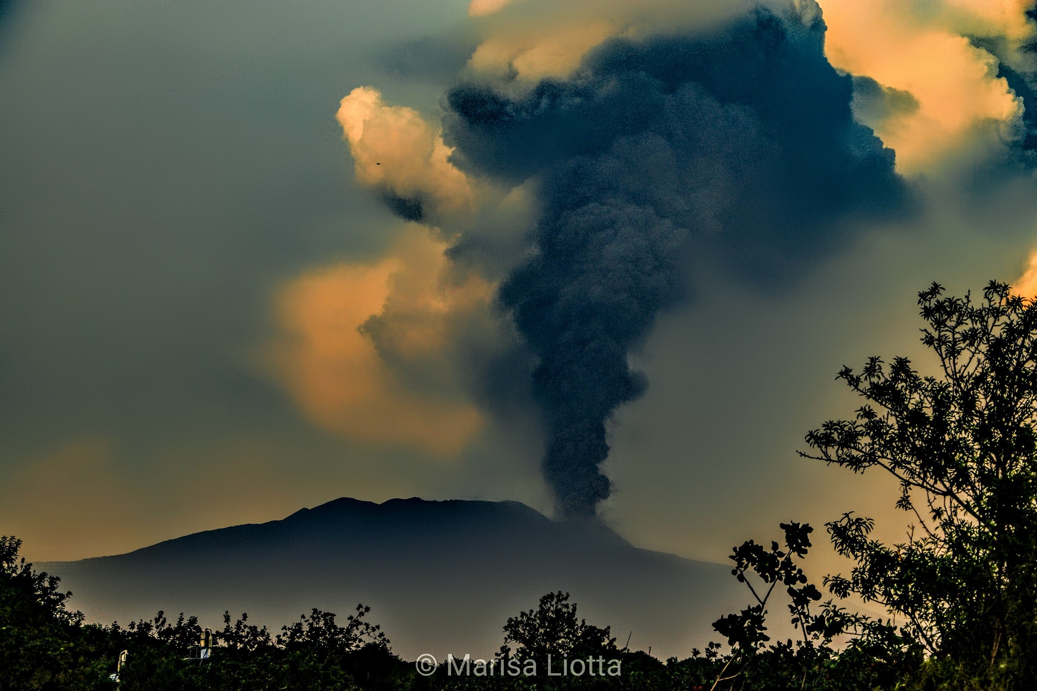
The National Institute of Geophysics and Volcanology, Osservatorio Etneo, reports that from the images of the surveillance cameras, it is observed that the explosive activity at the Southeast Crater has ceased. The eruptive cloud produced exceeded the height of 9 km and, according to the forecast model, its dispersion concerned the eastern sector of the volcano with lapilli falling to Fornazzo and Giarre. Regarding the lava overflow, described in previous releases, it seems poorly fed and the front seems to be at the same level as that indicated in the previous update (about 2900 m altitude). In addition, at the end of the lava fountain phase, it was possible to observe that the activity of the Southeast Crater produced a second lava overflow from its eastern edge which headed east. without going beyond the base of the crater.
The amplitude of the volcanic tremor is on average values with a downward trend. The locations of the tremor are still near the Southeast Crater at a depth of about 3000 m. The infrasound activity decreased considerably, reaching a low level.
The stations of the inclinometric network recorded modest variations. No significant change is observed in the signals acquired by the GNSS network.
From the images of the surveillance cameras, two small lava flows can be observed from two effusive vents that opened in the lower part of the South-East flank of the South-East Crater, respectively at 04:25 UTC for the upper vent and at 05:59 UTC for the lower vent. At 07:00 UTC, the flow front fed by the highest effusive vent reached the altitude of the second lava flow. For the moment, the two lava flows are well fed and the most advanced front seems to have almost reached the western edge of the Valle del Bove, settling at an altitude estimated at around 2900 m above sea level. An inspection is underway by the staff of the Osservatorio Etneo. Regarding the two lava overflows produced during the lava fountain episode, based on surveillance camera footage, they both appear to be cooling.
Press release on ETNA activity, 23 June 2021, 19:39 (17:39 UTC).
The National Institute of Geophysics and Volcanology, Osservatorio Etneo, announces that from approximately 17:17 UTC, from surveillance cameras, the resumption of weak Strombolian activity of the Southeast Crater is observed. From approximately 16:30 UTC, there is a sudden increase in the mean amplitude of the volcanic tremor which, at present, has reached the high value range. The location of the sources of the volcanic tremor is located near the Southeast Crater at an altitude of 2900-3000 m above sea level. The infrasound activity appears to be low.
From approximately 17:45 UTC, an increase in Strombolian activity at the level of the Southeast Crater is observed from the surveillance cameras with the emission of ash which, according to the forecast model, disperse in the East direction -South East. From the seismic point of view, compared to the previous situation, the sudden increase in the average amplitude of the volcanic tremor is confirmed. From around 6:00 p.m. UTC, there is a significant increase in infrasonic activity, both in the number and extent of events. No significant change is observed in the distortion signals recorded on the inclinometric and GNSS networks.
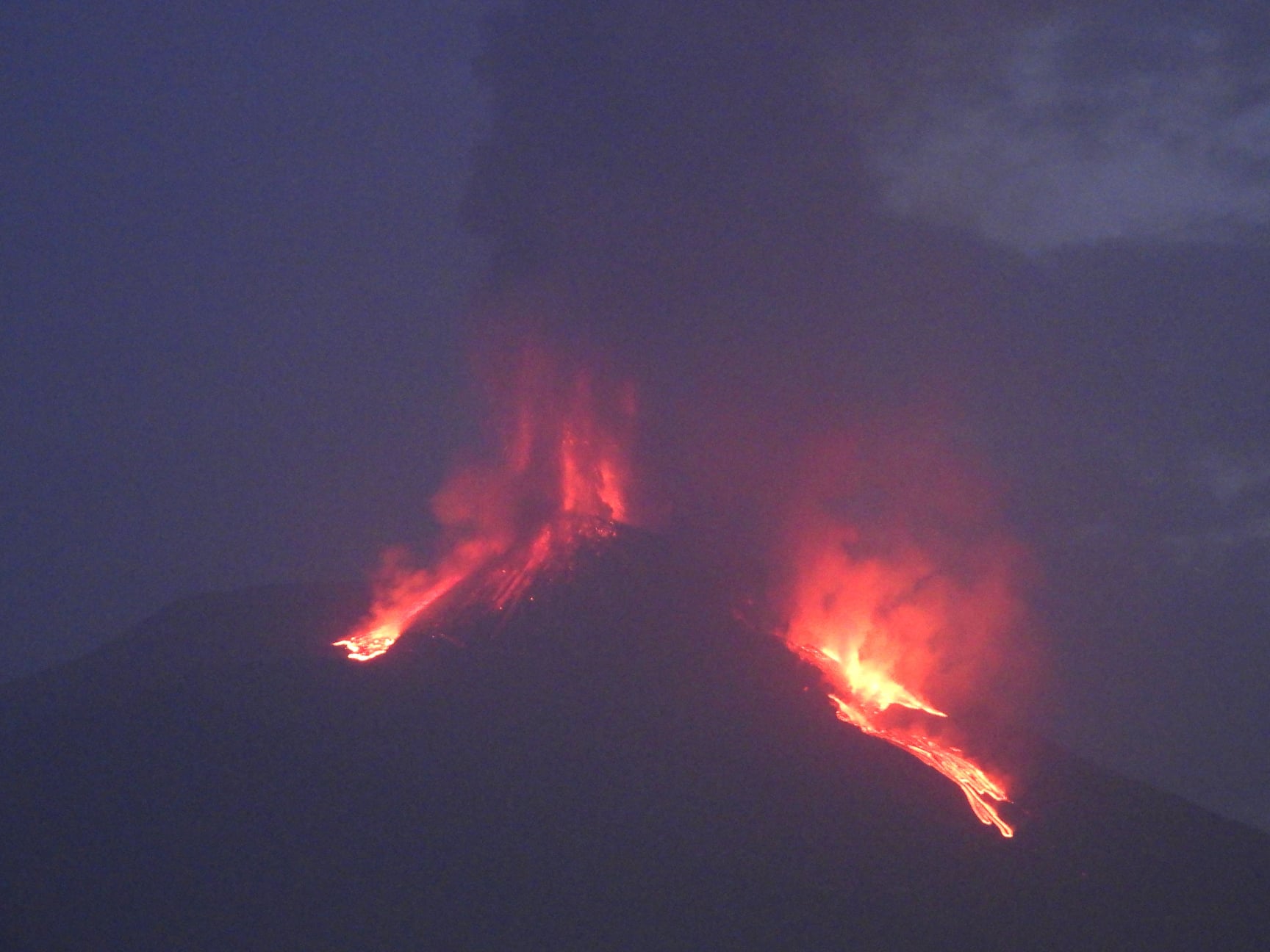
At around 6:00 p.m. UTC, we observe from surveillance cameras that the Strombolian activity of the Southeast Crater has gradually passed into the lava fountain stage. Based on the forecast model, the eruptive cloud, which reaches a height of about 9 km above sea level, disperses in an East-North-East direction. In addition, from 18:28 UTC, an eruptive vent is observed on the eastern high slope of the Southeast Crater which produces an explosive activity and a lava flow which propagates towards the East.
Press release on ETNA activity, 23 June 2021, 21:54 (19:54 UTC).
The National Institute of Geophysics and Volcanology, Osservatorio Etneo, reports that as of 19:00 UTC, the lava fountain in the Southeast Crater gradually ran out. In accordance with the forecast model, the dispersion of the eruptive cloud concerned the East-North-East sector of the volcano. The eruptive cloud reached a height of about 9 km above sea level. The lava fountain also produced an overflow of lava along the southern slope of the Southeast Crater, which spread into a south-west direction, whose front is currently at an altitude estimated at about 2900 m altitude.In addition, during the fountain episode, the opening of an eruptive vent was observed in the upper part of the eastern slope of the Southeast Crater. This vent produces modest explosive activity and lava effusion, with flows emptying into the upper area of the Valle del Bove. At present, the most advanced front is located at an altitude estimated at about 2700 m above sea level. Currently, a weak Strombolian activity persists at the level of the Southeast Crater.
After the maximum reached at 18:50 UTC, the amplitude of the volcanic tremor rapidly decreased, remaining for the moment at medium-high values. The locations of the tremor remain in the area of the Southeast Crater at an altitude of about 2900 m.
The infrasound activity has also suffered a sharp decrease and is currently at a low level.
During the lava fountain phase, the stations of the inclinometric network recorded modest variations. No significant change is observed in the signals acquired by the GNSS network.
Press release on ETNA activity, June 24, 2021, 06:48 (04:48 UTC).
After the cessation of the lava fountain activity at the Southeast Crater, a weak Strombolian activity with ash emission continued for a few tens of minutes, which was gradually exhausted. During the night and at dawn, weak effusive activity continued at the open mouths at the South-East base of the South-East Crater, which fed a lava flow on the West wall of the Valle del Bove with a front at about 2600 m. At dawn today a small flow was active near the effusive mouth, which measured a few tens of meters long. No explosive activity is currently observed at the level of the Southeast Crater.
The magnitude of the volcanic tremor over the past few hours has remained at low levels showing an uptrend only since 3:30 UTC. The sources of the tremor continue to be located near the Southeast Crater at an altitude of about 2800 m above sea level. The infrasound activity is high with the locations of the events corresponding to the crater of Bocca Nuova.
Further updates will be communicated shortly.
Source : INGV.
Photos : Giuseppe Tonzuso, Boris Behncke , Marisa Liotta.
Video : Boris Behncke .
Chile , Nevados de Chillan :
Special Report on Volcanic Activity (REAV), Ñuble region, Nevados de Chillán volcanic complex, June 23, 2021, 11:56 p.m. local time (Continental Chile).
The National Service of Geology and Mines of Chile (Sernageomin) publishes the following PRELIMINARY information, obtained thanks to the monitoring equipment of the National Volcanic Monitoring Network (RNVV), processed and analyzed in the Volcanological Observatory of the Southern Andes ( Ovdas):
On Wednesday, June 23, at 11:50 p.m. local time (03:05 UTC on June 24), monitoring stations installed near the Nevados de Chillán volcanic complex recorded a long-period type earthquake, associated with fluid dynamics in the volcanic system. .
The characteristics of the earthquake after its analysis are as follows:
TIME OF ORIGIN: 11:50 p.m. local time (03:55 UTC on June 24)
LATITUDE: 36.860 ° S
LONGITUDE: 71.381 ° W
DEPTH: 0.7 km
REDUCED DISPLACEMENT: 663 (cm2)
ACOUSTIC SIGNAL: No signal has been recorded.
Observations:
With the weather conditions, it was not possible to observe the volcano.
The volcanic technical alert remains at the Yellow level.
Source : Sernageomin.
Photo : Josefauna .
Saint Vincent , Soufrière Saint Vincent :
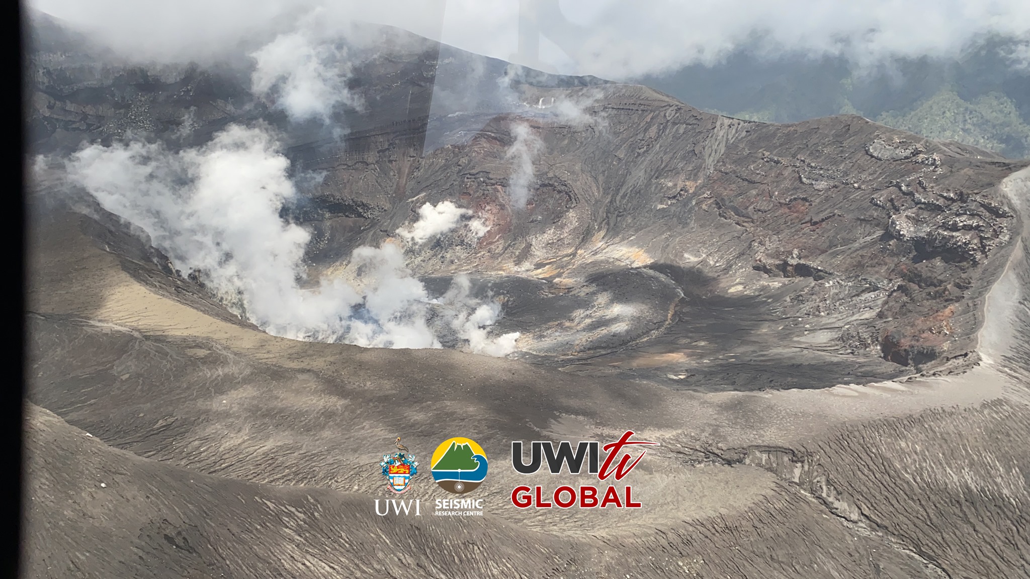
Soufriere Volcano – SCIENTIFIC UPDATE 22/06/21 1:00PM
-Seismic activity at La Soufrière, St Vincent has remained low since the tremor associated with the explosion and ash venting on 22 April. In the last 24 hours, only a few small earthquakes have been recorded.
– Persistent steam emissions from a few regions inside the crater continue to be the dominant observable feature.
– Thermal anomalies in the crater continue to be detected but do not indicate an explosive event is imminent but that there is a source of heat, most likely from a small body of magma left over, close to the floor of the Summit Crater.
– Measurement of the sulphur dioxide (SO2) flux was carried out off the west coast on June 18th and yielded an average SO2 flux of 479 tons/day. SO2 can be an indicator that fresh magma from a deeper source is being degassed.
– An increase in the smell of sulphur in Richmond and Chateaubelair regions has also been reported. This can happen when wind direction carries the SO2 plume towards this direction.
– Work is underway to restore capacity lost during the explosive phase of the eruption. This will continue until the end of June 7.
– The volcano continues to be in a state of unrest. While volcanic activity has been on a decline the continued presence of near surface hot spots, daily seismic activity and substantial degassing is proof that the system is still in unrest and escalation in activity can still take place with little or no warning.
– The volcano is at alert level ORANGE.
Source et photo : UWI.
Japan , Suwanosejima :
JMA reported that 15 explosions at Suwanosejima’s Ontake Crater produced eruption plumes that rose as high as 1.8 km above the crater rim during 11-18 June. Large volcanic bombs were ejected 500 m from the crater. Ashfall was reported in Toshima village (4 km SSW). Crater incandescence was visible nightly. The Alert Level remained at 2 and the public was warned to stay 1 km away from the crater.
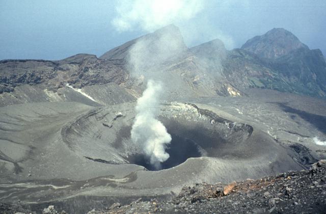
The 8-km-long, spindle-shaped island of Suwanosejima in the northern Ryukyu Islands consists of an andesitic stratovolcano with two historically active summit craters. The summit is truncated by a large breached crater extending to the sea on the east flank that was formed by edifice collapse. Suwanosejima, one of Japan’s most frequently active volcanoes, was in a state of intermittent strombolian activity from Otake, the NE summit crater, that began in 1949 and lasted until 1996, after which periods of inactivity lengthened. The largest historical eruption took place in 1813-14, when thick scoria deposits blanketed residential areas, and the SW crater produced two lava flows that reached the western coast. At the end of the eruption the summit of Otake collapsed forming a large debris avalanche and creating the horseshoe-shaped Sakuchi caldera, which extends to the eastern coast. The island remained uninhabited for about 70 years after the 1813-1814 eruption. Lava flows reached the eastern coast of the island in 1884. Only about 50 people live on the island.
Source : Japan Meteorological Agency (JMA)
Photo : Yukio Hayakawa, 1998 (Gunma University).
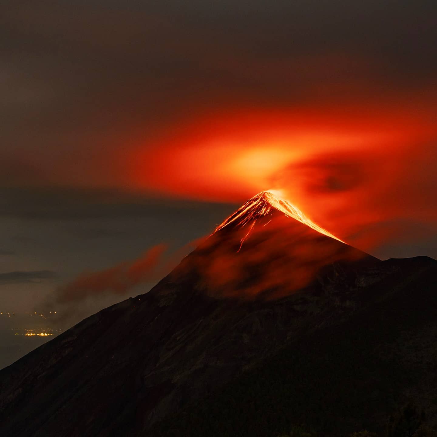
Guatemala , Fuego :
INSIVUMEH reported that on 15 June lahars descended the Las Lajas and El Jute drainages on Fuego’s SE flank, carrying tree branches and blocks as large as 1.5 m in diameter. During 16-22 June there were 4-15 explosions per hour, generating ash plumes as high as 1.1 km above the crater rim. Daily shock waves rattled buildings in towns around the volcano, and within 15 km of the S and SW flanks during 20-21 June. Ashfall was reported almost daily in several areas downwind, including Panimaché I and II (8 km SW), Santa Sofía (12 km SW), Sangre de Cristo (8 km WSW), and San Pedro Yepocapa (8 km NW). Block avalanches descended the Ceniza (SSW), Seca (W), Trinidad (S), Taniluyá (SW), Las Lajas (SE), and Honda drainages, often reaching vegetated areas. Explosions ejected incandescent material 100-350 m above the summit each day.
Activity:
6 to 10 explosions per hour of weak to moderate characteristics were recorded, expelling plumes of gas and abundant ash at an altitude of 4,500 to 4,800 meters (14,763 to 15,748 feet) and dispersing to the northwest, West and Southwest. As a result of the explosions, incandescent pulses of 100 to 200 meters are generated on the crater with weak, moderate and strong avalanches towards the ravines Seca, Ceniza, Trinidad, Taniluyá and Las Lajas, some reaching the edge of the vegetation. Weak and moderate rumblings were recorded, accompanied by shock waves of weak to moderate characteristics that vibrate the roofs and windows of houses around the volcano. Fine ash falls were reported in communities located on the western and northwestern flanks.
Source : GVP , Insivumeh.
Photo : Diego Rizzo .