January 06 , 2021 .
Italy / Sicily , Etna :
Weekly bulletin from December 28, 2020 to January 03, 2021 (issue date January 05, 2021)
SUMMARY OF THE STATE OF ACTIVITY
In the light of surveillance data, it is highlighted:
1) VOLCANOLOGICAL OBSERVATIONS: Strombolian activity of variable intensity associated with ash emissions from the Southeast crater. Intra-crater strombolian activity at the Northeast crater, at the Voragine and at the Bocca Nuova with rare and diluted ash emissions.
2) SEISMOLOGY: Seismic activity of average fracturing; amplitude of the volcanic tremor mainly at the average level.
3) INFRASOUND: moderate infrasound activity
4) DEFORMATIONS: No significant change to report
5) GEOCHEMISTRY: SO2 flow: average level of HCl flow: the last measurements are at an average level, the flow of CO2 from the soil is at medium-low levels.
The partial pressure of dissolved CO2 does not show significant changes.
There are no updates for the C / S report.
The isotope ratio of helium is at average values (last update 12/16/2020).
6) SATELLITE OBSERVATIONS: The thermal activity in the summit area is at a medium-low level.
VOLCANOLOGICAL OBSERVATIONS
During the week in question, the monitoring of the volcanic activity of Etna was carried out by analyzing the images of the network of surveillance cameras of the INGV, Osservatorio Etneo (INGV-OE) and thanks to an inspection carried out by INGV -OE staff on December 28.
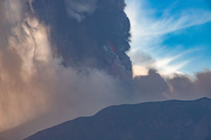
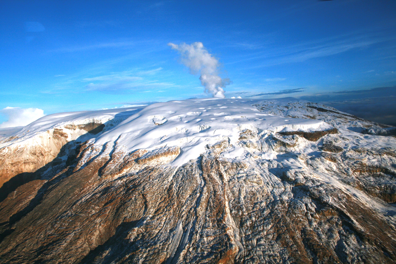
After the end of the lava fountain episode of the South-East crater on December 22 (see Rep. N ° 53/2020), Strombolian activity at the level of the summit craters continued with varying intensity and frequency. . In particular, the Southeast Crater (SEC) was characterized in the morning of December 29, from 06:50 UTC, by a gradual intensification of the explosive strombolian activity at the level of the eastern vent with associated emission of ash that Strong winds at high altitudes quickly dispersed to the east-northeast. At around 08:00 UTC, this activity intensified further, producing the launch of coarse pyroclastic material over the crater rim which fell copiously on the east side of the Southeast crater cone. From 09:00 UTC onwards, the intensity of the Strombolian explosive activity significantly decreased as well as the ash emission, which became weak and discontinuous, remaining confined to the summit area. In the following days, Strombolian explosive activity continued at the Southeast Crater mainly at the eastern vent, with varying intensity,
accompanied by sporadic emissions of dilute ash and secondarily and discontinuously from the saddle vent.
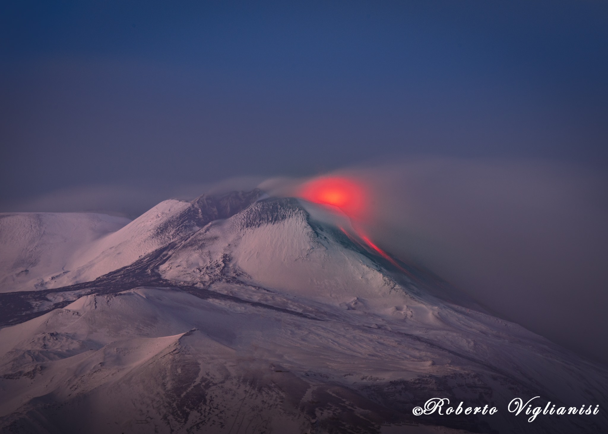
The Voragine Crater (VOR) was affected by continuous Strombolian intracrater activity which intensified from December 30, producing the launch of pyroclastic material beyond the edge of the crater. Finally, intracrater Strombolian activity in the craters of Bocca Nuova (BN) and North-East (NEC) continued unchanged, accompanied by sporadic emissions of dilute ash.
Volcanic tremor:
During the period considered, the amplitude of the volcanic tremor was constantly maintained in the average amplitude range despite wide fluctuations. The source of the tremor was constantly located in the area of the Southeast crater, at a depth of about 2800-2900 m above mean sea level
Source : INGV.
Photos : INGV , Roberto Viglianisi .
Italy , Stromboli :
Weekly bulletin from December 28, 2020 to January 03, 2021 (issue date January 05, 2021)
SUMMARY OF THE STATE OF ACTIVITY.
In the light of surveillance data, it is highlighted:
1) VOLCANOLOGICAL OBSERVATIONS: Normal explosive volcanic activity of Strombolian type on medium-low and medium levels (8-14 events / h) with projection activity in the North zone. The intensity of the explosions was mainly medium-low in the areas of the North and Center-South crater.
2) SEISMOLOGY: The seismological parameters do not show significant variations.
3) DEFORMATIONS: No significant change to report
4) GEOCHEMISTRY: SO2 flux: medium level
C / S Ratio – There is no updated data to date: the last available values referring to 06-12-2020 are on average levels (C / S = 12.1).
The isotopic ratio of Helium is at fairly high values (R / Ra = 4.4 compared to the sampling of December 21).
5) SATELLITE OBSERVATIONS: The thermal activity in the summit area is at a low level.
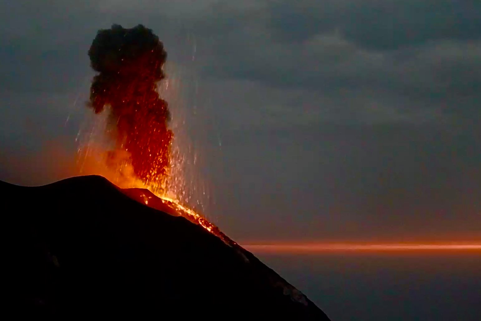
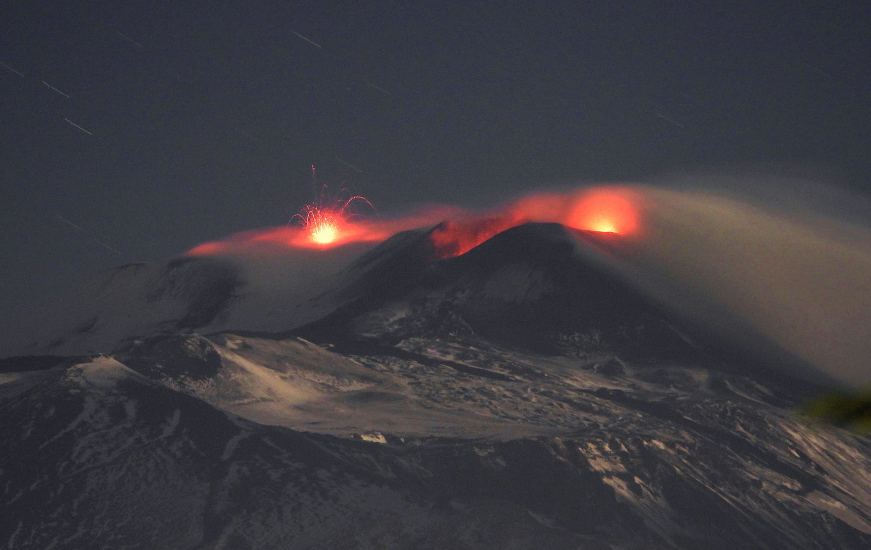
During the period under observation, the eruptive activity of Stromboli was characterized by the analysis of the images recorded by the surveillance cameras INGV-OE located at 190 m altitude, Punta Corvi and 400 m.
In the area of the North crater, the N1 crater, with two emission points, produced low intensity explosions (less than 80 m high) emitting fine materials (ash) mixed with coarse materials (lapilli and bombs) . Vent N2, with four emission points, showed mainly low and medium intensity explosive activity (less than 150 m in height) emitting coarse materials. In addition, a projection activity was observed at the N2 vent which for long periods was intense with the construction of certain hornitos which generated jets of incandescent material.
The average frequency of the explosions varied from 7 to 12 events / h.
In the Center-South zone, the explosions emitted mainly fine materials, with an average intensity (the products reached 150 m in height). Explosive activity showed hourly frequency values ranging from less than 1 to 4 events / h.
Source : INGV.
Photo : Webcam
Hawaii , Kilauea :
19°25’16 » N 155°17’13 » W,
Summit Elevation 4091 ft (1247 m)
Current Volcano Alert Level: WATCH
Current Aviation Color Code: ORANGE
Activity Summary:
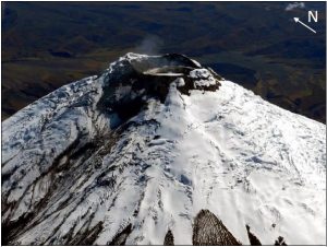
Lava activity is confined to Halemaʻumaʻu with lava erupting from vents on the northwest side of the crater. Monday afternoon (Jan. 4), the lava lake was 191 m (627 ft) deep and perched above its edge. SO2 emission rates were still elevated.
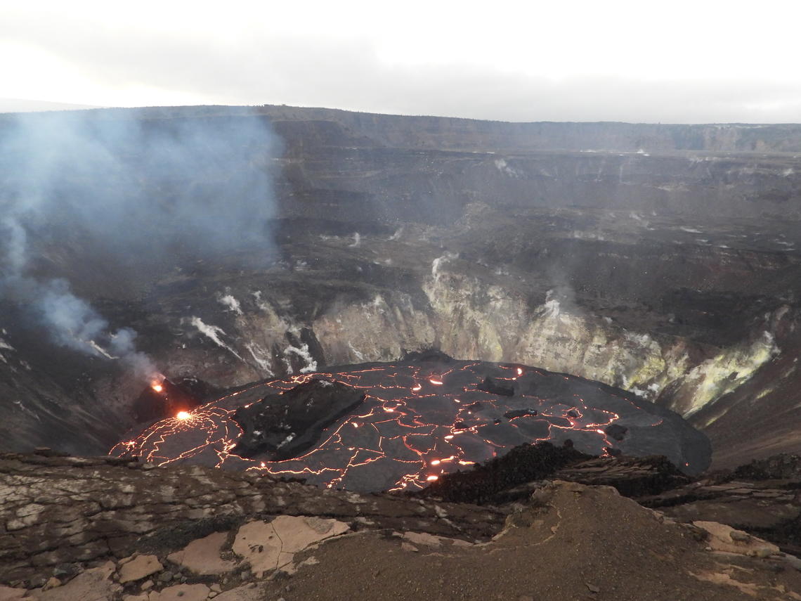
The ongoing eruption at Kīlauea Volcano’s summit, within Halema‘uma‘u crater, continues to erupt from the west vent (left). Yesterday evening, January 4, the lava lake was measured at approximately 191 m (626 ft) deep. No major changes have been observed over the past week. HVO scientists continue to monitor the eruption within an area of Hawai‘i Volcanoes National Park that remains closed to the public for safety reasons. View is looking to the north.
Summit Observations:
Sulfur dioxide emission rate measurements made on Sunday (Jan. 3) were still in the range 3,000-6,500 t/d since last Sunday (Dec. 27).
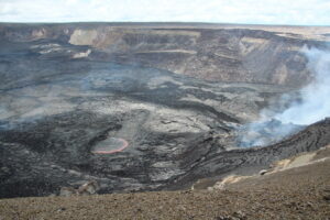
Halemaʻumaʻu lava lake Observations:
The west vents spattered from the top of a small cone plastered on the northwest wall of Halemaʻumaʻu crater. This morning, lava is flowing down an narrow channel to the lake and feeding a small dome fountain in front of the west vents probably from a submerged portion of the vent.
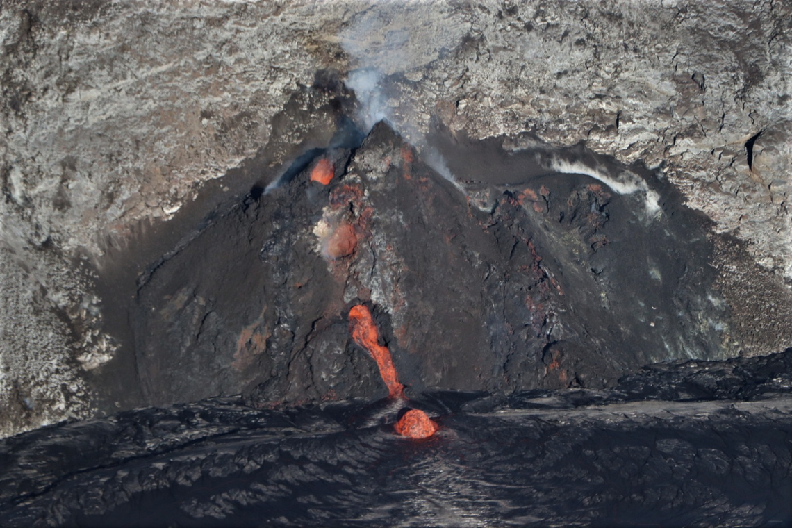
At approximately 8:00 a.m. HST this morning there was a small breakout from the lower part of the west vent tube. This telephoto aerial photograph taken at about 8:30 a.m. HST during a HVO overflight of Halema‘uma‘u crater, shows the newly exposed lava channel entering the lava lake. Lava also continues to enter the lava lake through the tube, which is producing the small dome fountain at the lake margin below (lower center).
The lava lake was 191 m (623 ft) deep Monday afternoon (Jan. 4) and had a volume of about 26 million cubic meters (34 million cubic yards). The most recent thermal map (Dec. 30) provided the lake dimensions as 800 by 530 m (875 by 580 yds) for a total area of 33 ha (82 acres) .
The main island of cooler, solidified lava floating in the lava lake continued settling, mostly rotating counter-clockwise, in front of the west lava source filling the lake, while the 11 smaller islands moved a bit but remained in the east end of the lake. .
Source : HVO.
Photos : USGS photo taken by M. Patrick , USGS photo taken by B. Carr .
Colombia , Nevado del Ruiz :
Nevado del Ruiz volcano activity bulletin.
The activity level continues at Yellow Activity Level or (III): changes in the behavior of volcanic activity.
Regarding the monitoring of the activity of the Nevado del Ruiz volcano, the COLOMBIAN GEOLOGICAL SERVICE reports that:
Seismicity generated by rock fracturing has decreased in the number of earthquakes and in the seismic energy released, compared to the previous week. This seismic activity was located mainly in the North-East, South-East, South, South-West sectors and in the Arenas crater. The depths of the earthquakes ranged from 0.2 to 6.4 km. The highest magnitude recorded during the week was 0.8 ML (local magnitude), corresponding to the earthquake that occurred on December 30 at 9:32 a.m. (local time), located in the Arenas crater, 1.0 km from depth.
The seismicity linked to the dynamics of the fluids inside the volcanic conduits, decreased in number of events and increased in seismic energy released, compared to the previous week. This seismic activity was characterized by the occurrence of continuous volcanic tremor, tremor pulses, earthquakes of long and very long period types, which presented variable energy levels and spectral content.
Over the past week, the MIROVA portal and Nasa Firms reported low-energy thermal anomalies over the volcano.
Source : SGC.
Photo : Auteur inconnu .