December 28 , 2020.
Hawaii , Kilauea :
19°25’16 » N 155°17’13 » W,
Summit Elevation 4091 ft (1247 m)
Current Volcano Alert Level: WATCH
Current Aviation Color Code: ORANGE
Activity Summary:
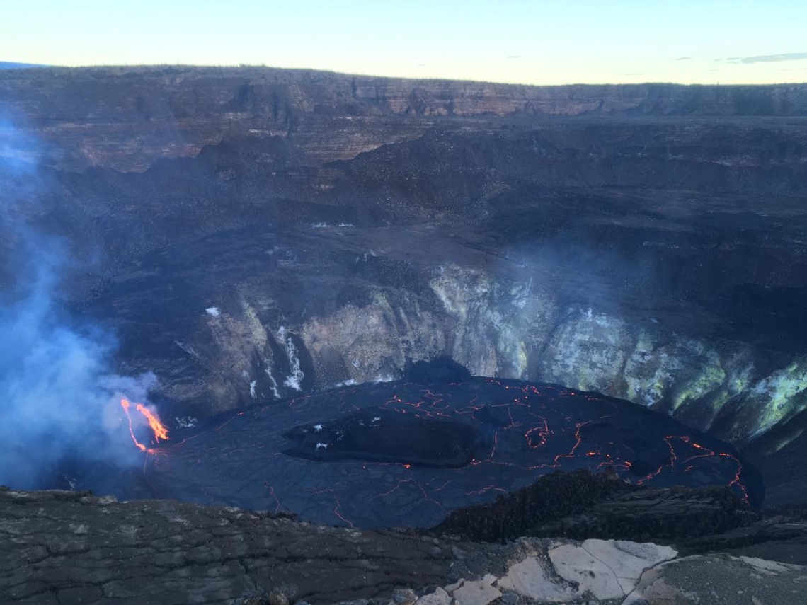
Lava activity is confined to Halemaʻumaʻu with lava erupting from a vent on the northwest side of the crater. As of 7 am this morning (Dec. 27), the lava lake was 177 m (581 ft) deep with a narrow black ledge around it. Reduced SO2 emissions were measured last night.
Summit Observations:
Preliminary analysis of sulfur dioxide emission rates measured yesterday afternoon (Dec. 26) show that the rates have dropped to about 5,000 tonnes/day from about 40,000 t/d (Dec. 21-23) and about 20,000 t/d (Dec. 25). Summit tiltmeters continued to record weak inflationary tilt. Seismicity remained elevated but stable, with steady elevated tremor and a few minor earthquakes.
HVO field crews were unable to observe early morning eruption activity in Halema‘uma‘u crater at Kīlauea’s summit due to high winds. Upon return to the eruption site this morning, HVO field crews noted the reduced vigor at the western vent. The northern/eastern vent remains inactive. At approximately 7:30 a.m. HST today (Dec. 27), HVO field crews measured the lava lake as 177 m (581 ft) deep. The lava lake level has not changed significantly over the past 24 hours.
East Rift Zone Observations:
Geodetic monitors also indicate that the upper portion of the East Rift Zone contracted while the summit deflated. This was associated with magma withdrawal to feed the summit vents. There is no seismic or deformation data to indicate that magma is moving into either of Kīlauea’s rift zones.
Halemaʻumaʻu lava lake Observations:
The west vent continued erupting lava into a lava lake within Halemaʻumaʻu crater with two narrow channels visible and slightly reduced vigor this morning.
The lava lake within Halemaʻumaʻu crater has changed little in the past day and was about 177 m (581 ft) deep and about 408 m (1,340 ft) below the south Halemaʻumaʻu rim as of this morning (Dec. 27). The lake volume remained about 21 million cubic meters (27 million cubic yards or 4.8 billion gallons). The most recent thermal map provided the lake dimensions as 790 by 520 m (864 by 569 yds) for a total area of 29 ha (72 acres). The narrow (10-30 m or 11-22 yd) ledge around the lake was about 1-2 m (1-2 yds) above the active lake surface suggesting that the lake surface dropped over the past 2 days (https://www.usgs.gov/media/images/december-26-2020-k-lauea-summit-eruption-thermal-map)
Over the past day, the island of cooler, solidified lava floating in the lava lake drifted slowly westward in the lake and remained stable in size–about 260 m (850 ft) in length and 115 m (375 ft) in width based on the Dec. 23rd thermal map (https://www.usgs.gov/maps/december-23-2020-k-lauea-summit-eruption-thermal-map). Measurements this morning suggest that the island rose 1-2 m (3-7 ft) since yesterday afternoon.
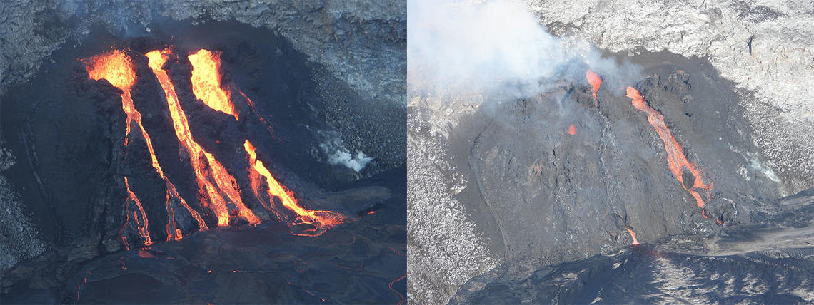
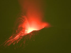
The ongoing eruption within Halema‘uma‘u crater continues at the western fissure vents. Yesterday morning, December 26 around 2:40 a.m. HST, all three vents increased in eruptive vigor and were sending channels of lava into the lava lake. The increase in lava discharge from the western vents continued into yesterday afternoon (left photo). Today, December 27, the eruptive activity appears to have slightly decreased. This morning at approximately 9:30 a.m. HST (right photo) the western-most vent (left) had a small skylight visible with occasional spatter ejected. The central vent channel was crusted over, but a swift stream was visibly entering the lava lake near the tubes base. The eastern (right) vent continues to produce an open channel that feeds into the lava lake.
Hazard Analysis:
High levels of volcanic gas, rockfalls, explosions, and volcanic glass particles are the primary hazards of concern regarding this new activity at Kīlauea’s summit. Large amounts of volcanic gas—primarily water vapor (H2O), carbon dioxide (CO2), and sulfur dioxide (SO2)—are continuously released during eruptions of Kīlauea Volcano. As SO2 is released from the summit during this new eruption, it will react in the atmosphere with oxygen, sunlight, moisture, and other gases and particles, and within hours to days, convert to fine particles. The particles scatter sunlight and cause the visible haze that has been observed downwind of Kīlauea, known as vog (volcanic smog), during previous summit eruptions. Vog creates the potential for airborne health hazards to residents and visitors, damages agricultural crops and other plants, and affects livestock operations.
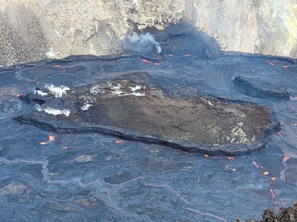
A zoomed photo of the Halema‘uma‘u crater lava lake at Kīlauea Volcano’s summit. The northern fissure vent (upper center) is inactive and slow lava lake draining continues at the site. The “bathtub ring” of cooled lava is visible around the perimeter of the lava lake, and the several meters (yards) of lava level drop is also visible around the rafted island (center).
Rockfalls and minor explosions, such as the ones that occurred during the 2008–2018 lava lake eruption at Kīlauea summit, may occur suddenly and without warning. This underscores the extremely hazardous nature of Kīlauea caldera rim surrounding Halemaʻumaʻu crater, an area that has been closed to the public since late 2007. Pele’s hair and other lightweight volcanic glass fragments from the lava fountains within Halemaʻumaʻu will fall downwind of the fissure vents and lava lake, dusting the ground within a few hundred meters (yards) of the vent. High winds may waft lighter particles to greater distances. Residents are urged to minimize exposure to these volcanic particles, which can cause skin and eye irritation similar to volcanic ash.
Source : HVO.
Photos : USGS photos by M. Patrick. USGS photo by N. Deligne.
New Zealand , Ruapehu :
Mt Ruapehu Crater Lake temperature down to 41 ̊C but volcanic tremor still elevated . Published: Mon Dec 28 2020 1:00 PM
Volcanic Alert Level remains at 2
Aviation Colour Code remains at Yellow
During the past week, the temperature of the crater lake (Te Wai ā-moe) at Mt Ruapehu has decreased from 43 to 41 °C. The level of volcanic tremor continues to be moderate to strong and a small number of shallow volcanic earthquakes have been recorded. While the crater lake may have stopped heating, volcanic activity at Mt Ruapehu remains elevated. The Volcanic Alert Level remains at Level 2 and the Aviation Colour Code remains at Yellow.
Since our last update (VAB RUA – 2020/10), Ruapehu’s Crater Lake (Te Wai ā-moe) temperature has decreased slightly. The temperature reached a maximum of 43 ºC on Monday 21st December that subsequently declined to ~41 ºC. A lake temperature peak of ~ 40-46 ºC is common during these heating-cooling cycles; on at least 7 occasions since 2007, the lake temperature exceeded 40 ºC. Using this lake temperature decrease, we estimate that the energy input into the lake has decreased from ~400 to ~200 MW (megawatt).
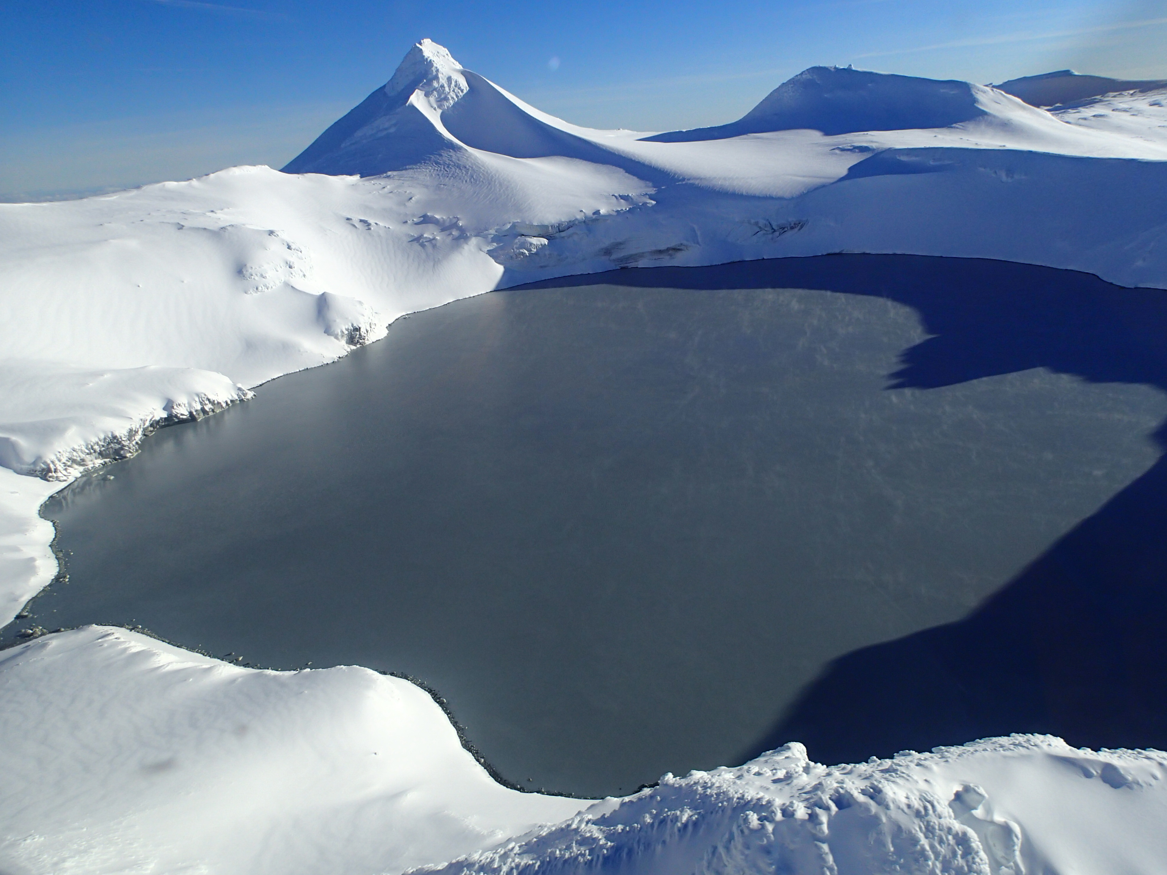
Elevated volcanic tremor is still ongoing along with a few volcanic earthquakes. The largest of these earthquakes (M2.2) occurred on 26th December and was located under the volcano. Volcanic earthquakes of this size are uncommon and the combination with elevated tremor and still high lake temperature indicate moderate to heightened volcanic unrest. Because of this, the Volcanic Alert Level remains at Level 2.
We continue to closely monitor Ruapehu, and this week we will attempt a gas flight to measure volcanic gas emissions. We will also attempt to sample the water at the crater lake for further chemical analyses. Together, these will help us identify processes occurring at depth beneath the volcano.
The Volcanic Alert Level is still at Level 2 which reflects the current level of volcanic activity. Mt Ruapehu is an active volcano and has the potential to erupt with little or no warning when in a state of volcanic unrest. The Aviation Colour Code remains at Yellow.
Volcanic Alert Level 2 indicates the primary hazards are those expected during volcanic unrest: steam discharge, volcanic gas, earthquakes, landslides and hydrothermal activity. While Volcanic Alert Level 2 is mostly associated with environmental hazards, eruptions can still occur with little or no warning.
Source : Geonet / Agnes Mazot , Duty Volcanologist.
Photo : Geonet.
Chile , Nevados of Chillan :
During the period, 192 seismic events classified as being of volcano-tectonic type were recorded, associated with fragile rupture processes in volcanic systems; the most energetic event recorded a local magnitude (ML) value of 2.8 and was located 1.5 km northeast with a depth of 3.9 km. In addition, 1093 seismic events classified as long period type were recorded, associated with the dynamics of fluids present in a volcanic system; the largest earthquake had an energy estimated from the reduced displacement parameter (DR) equal to 466 cm2. Finally, 518 seismic events were classified as being of the tremor type, associated with the sustained dynamics of the fluids present in the volcanic system; the highest tremor had a DR value equal to 141 cm2.
– 551 events were identified as discrete explosive activity. The higher energy explosion had a seismic signal associated with a DR equal to 466 cm2.
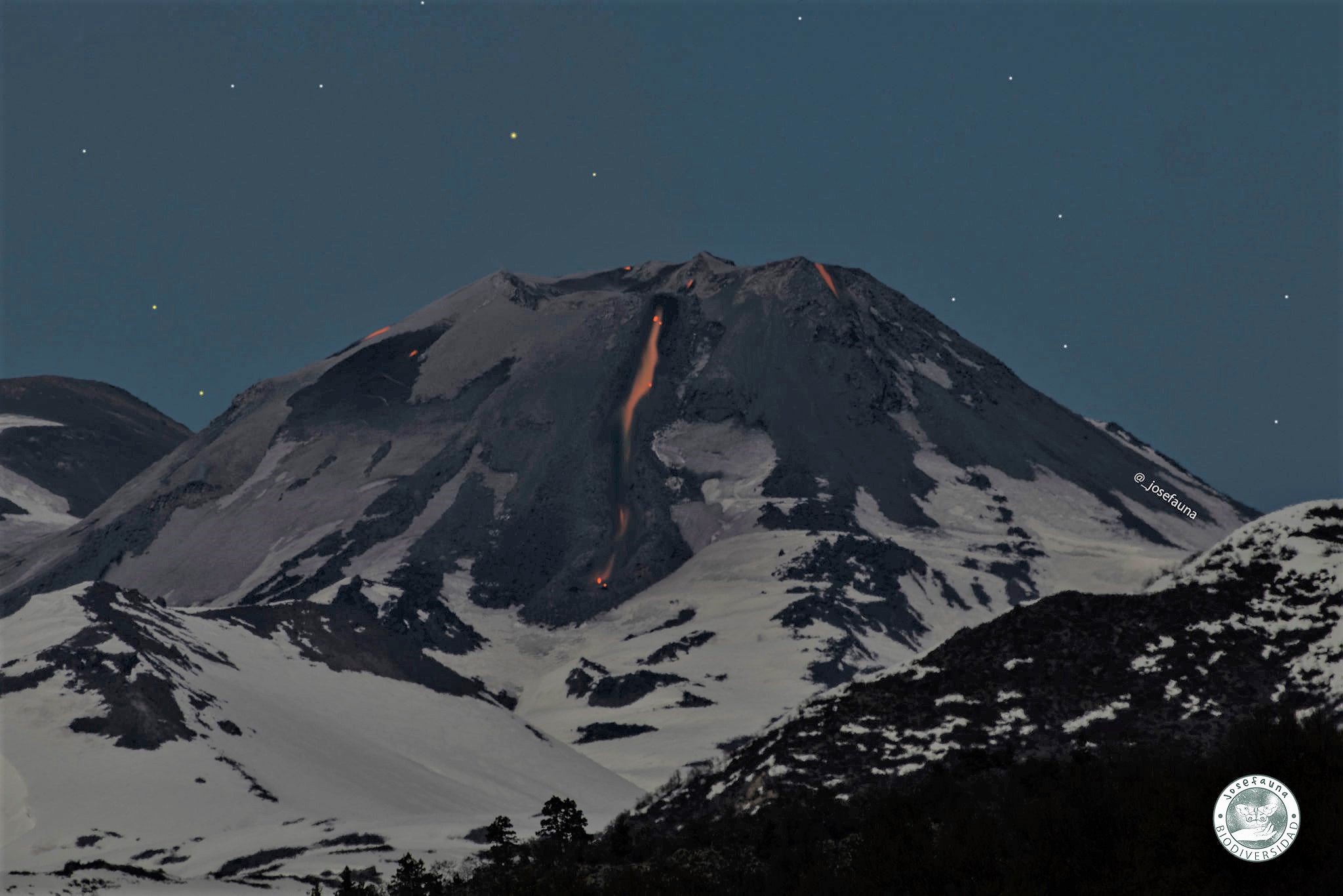
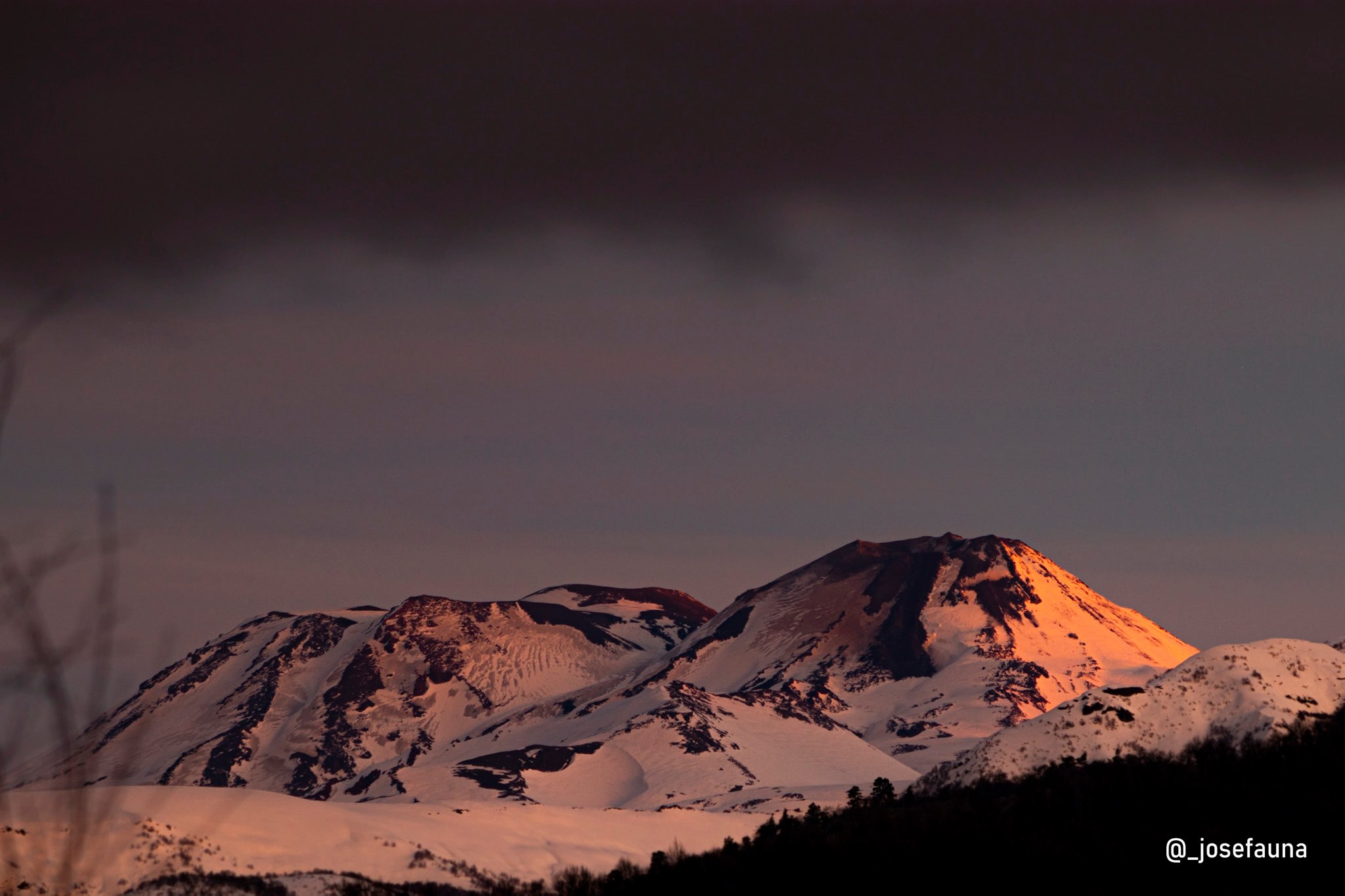
– The images provided by the fixed cameras installed around the complex made it possible to observe effusive and explosive activity during this fortnight. This activity was characterized by the presence of explosions with low to medium height columns (<1240 m) and a moderate content of particulate matter; most of the visible explosions come from the dome nestled in the active crater (Nicanor crater). When weather conditions permitted, day and night incandescence was appreciated, recurring and focused on the eastern edge of the crater.
– Concerning the effusive activity, the development of the extrusive process of the lava flow called « L5 » continues, the distribution of which has exceeded the northern limit of the active crater towards the northern slope of the volcano. This lava flow, to date, reaches a distance of 750 m and a thickness of about 20 m in its distal part. Compared to the forward speed of the lava front, a value of 0.16 m / hour was recorded during the fortnight of December, with a volume of 579,922 m3, value estimated around mid-November 2020.
Regarding the area of the dome nestled in the Nicanor crater, a greater vertical development of it is recognized, exceeding 45 m in maximum thickness and an approximate volume of 222,768 m3, a value also estimated around mid-November 2020 . Using satellite image photo-interpretation techniques (Planet Scope), morphological variations linked to the presence of a surface explosion crater were identified, consistent with daytime and nighttime explosive episodes with emission of fragments of incandescent rock, for which a process of partial destruction of the dome is deduced.
Moreover, thanks to the observations made during an overflight, the development of a crack to the north of the nested dome was recognized, estimated at 50 m in a north-east-south-west direction and at least 10 m deep; its northern end connects with the start of the central channel of the L5 lava flow.
– By processing the available thermal images, maximum temperatures of 338 ° C were observed during the occurrence of explosions and 182 ° C for the L5 lava flow currently located on the North slope.
According to the data provided by the monitoring stations which measure the deformation in the volcanic complex (5 GNSS and 2 inclinometers), a change is observed in the movements of all the stations, testifying to an inflationary process, possibly linked to increases in pressure inside volcanic conduits; The above also implies that the vertical components and line lengths between GNSS stations show this clear trend of inflation and elongation respectively, with maximum rates of 0.5 cm / month in horizontal shifts and a maximum of 1 , 1 cm / month in vertical movements, considered high.
The Nevados de Chillán Volcanic Complex continues to evolve gradually, remaining in the context of a sustained eruptive cycle linked to phases of effusive activity (advance of the L5 lava flow) and low explosiveness, due to growth and to the partial destruction of the lava dome. This dome, currently located inside the active crater, extends to the eastern edge (E), increasing the probability of gravitational collapses towards the eastern side (E) of the volcanic edifice. The data which helps to show the distortion associated with the internal dynamics continue to show an increasing trend of the vertical components, suggesting the permanence of an inflationary process. The seismic activity resulting from fluid dynamics exhibited a decrease in its energy, still exhibiting behavior with a stable trend. Seismicity associated with fluid dynamics, explosions, as well as thermal warnings, low-level degassing and the inflationary process, continue to be consistent with the development of surface magmatic bodies. Despite the above, the evolution of the current process does not show signs for the moment suggesting a greater destabilization of the volcanic system.
Therefore, the alert is maintained in:
YELLOW TECHNICAL ALERT: Changes in the behavior of volcanic activity.
Source : Sernageomin .
Photos : Josefauna ,
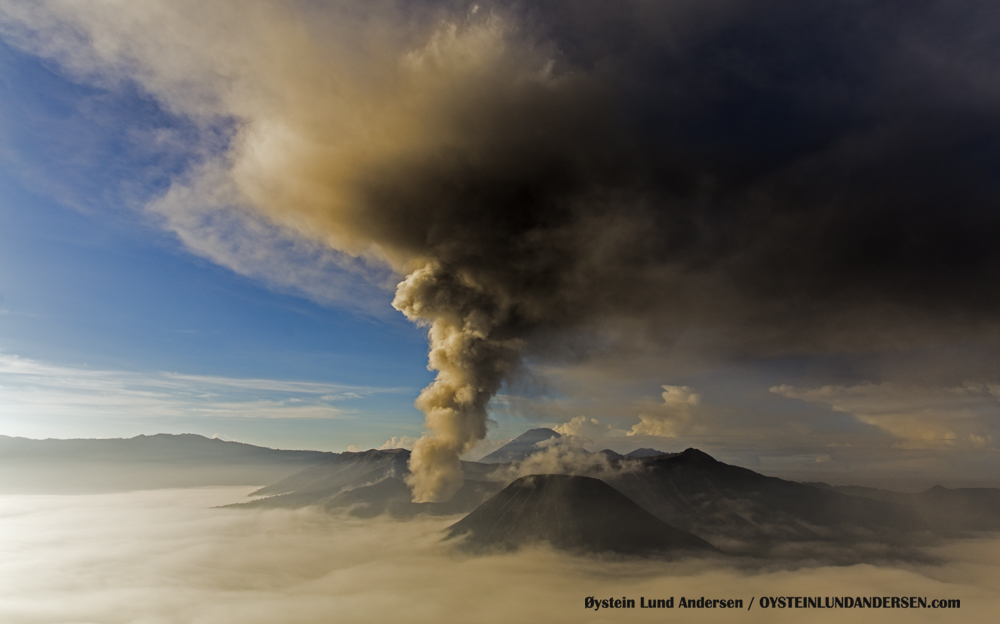
Indonesia , Bromo :
VOLCANO OBSERVATORY NOTICE FOR AVIATION – VONA.
Issued : December 28 , 2020
Volcano : Bromo (263310)
Current Aviation Colour Code : ORANGE
Previous Aviation Colour Code : unassigned
Source : Bromo Volcano Observatory
Notice Number : 2020BRO01
Volcano Location : S 07 deg 56 min 31 sec E 112 deg 57 min 00 sec
Area : East java, Indonesia
Summit Elevation : 7453 FT (2329 M)
Volcanic Activity Summary :
Gas emission produced volcanic ash observed at Eruption with at 22h50 UTC (05h50 local).
Volcanic Cloud Height :
Best estimate of ash-cloud top is around 9053 FT (2829 M) above sea level, may be higher than what can be observed clearly. Source of height data: ground observer.
Other Volcanic Cloud Information :
Gas emission with volcanic ash. Ashfall at Ngadirejo area, about 5 km northeast part from the crater.
Remarks :
Seismic activity is characterized by continuous tremor
Level of activity level II (WASPADA). Mount Bromo (2,329 m above sea level) is continuously erupting. The last eruption occurred on July 19, 2019, as the height of the eruption column was not observed.
The mountain was clearly visible until it was covered in fog. The crater was observed to emit weak, medium to thick, high white smoke about 50-600 meters from the summit. The weather is cloudy to rainy, with weak winds to the North, Northeast and East. There was a slight smell of sulfur at the Bromo PGA Post.
According to the seismographs of December 27, 2020, it was recorded: Continuous tremor, amplitude 0.5 to 1 mm (dominant value 1 mm)
Recommendation:
People around Mount Bromo and visitors / tourists / climbers should not enter the area with a radius of 1 km around the active crater of Mount Bromo
People around Mount Bromo, traders, tourists, mountaineers, and managers of Mount Bromo tourism should be aware of sudden phreatic eruptions without being preceded by obvious volcanic symptoms.
Source : Magma Indonésie . PVMBG.
Photo : Oystein Lund Andersen .