May 17 , 2020.
Italy / Sicily , Etna :
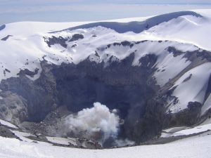
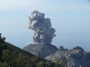
In the early hours of May 16, 2020, a new episode of modest Strombolian activity took place at the « saddle cone » of the New Crater of Southeastern Etna. Here are the press releases issued by the INGV-Observatoire Etnéan:
PRESS RELEASE OF VOLCANIC ACTIVITY from May 16, 2020, at 12:45:49 UTC (02:45:49 LOCAL HOURS) – ETNA.
The National Institute of Geophysics and Volcanology, Etnean Observatory, reports that the monitoring networks have recorded Strombolian activity at 02:45 hours (00:45 UTC).
From 00.45 hours UTC, the surveillance cameras revealed an explosive strombolian activity in the New Crater of the South-East, with regard to the mouth known as of the « saddle ». This activity quickly intensified, producing a modest cloud of ash which the winds dispersed at high altitude to the north.
From the seismic point of view, there is no significant variation in the recorded signals. The source of the volcanic tremor is located in the New Southeast Crater, at a depth of about 2900 m above sea level.
PRESS RELEASE OF VOLCANIC ACTIVITY from May 16, 2020, at 07:43:30 UTC (09:43:30 LOCAL HOURS) – ETNA.
The National Institute of Geophysics and Volcanology, Etnean Observatory, reports that from 6:45 am UTC, Strombolian activity in the New Southeast Crater, reported in the previous press release (n. 48) has ceased. During this, the explosive activity persists at the Voragine Crater, even if, according to the location survey carried out yesterday by INGV personnel, it has decreased in intensity and frequency. From the seismic point of view, the signals recorded over the past few hours show conditions of substantial stability compared to the table appearing in the previous press release, without any significant variation compared to average levels.
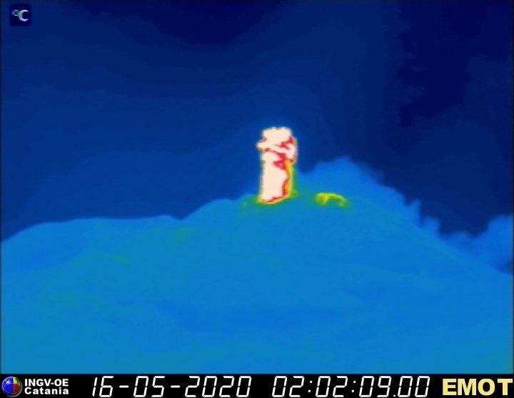
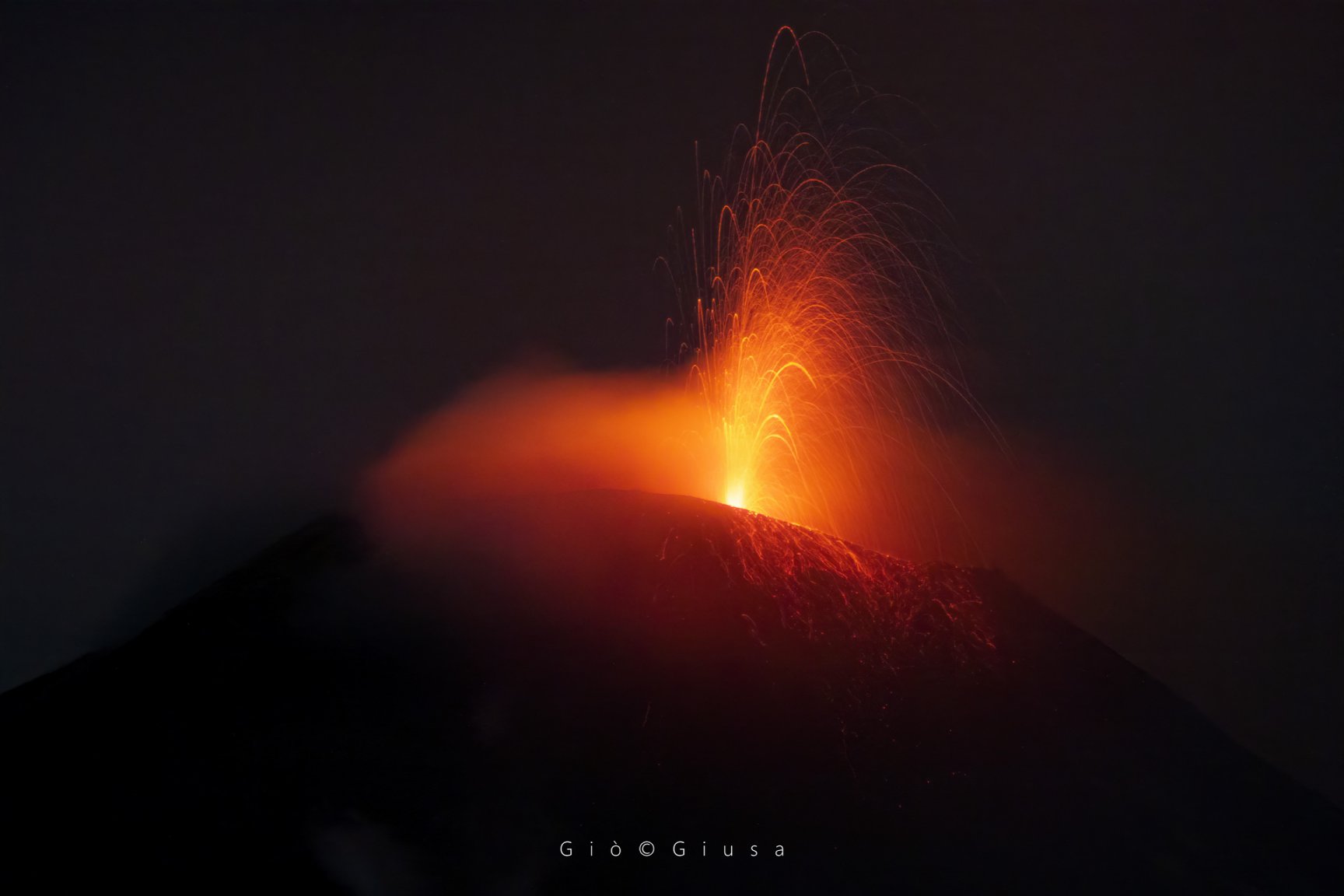
The images show a moment of the activity recorded by thermal surveillance cameras (first image) on the Montagnola, « EMOT » and « EMOV », the second image, a sublime shot of Gio Giusa.
Source : INGV Vulcani.
Alaska : Semisopochnoi :
51°55’44 » N 179°35’52 » E,
Summit Elevation 2625 ft (800 m)
Current Volcano Alert Level: ADVISORY
Current Aviation Color Code: YELLOW
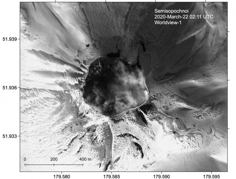
Clear Worldview-1 satellite image of the North Cerberus crater at Semisopochnoi on March 22, 2020.
Seismicity remains elevated with occasional low-frequency earthquakes and periods of continuous tremor. No other significant activity was detected in seismic data, and no eruptive activity was observed in regional infrasound data or cloudy satellite images.
Semisopochnoi is monitored by local seismic sensors, satellite data, and lightning detection networks. An infrasound array on Adak Island may detect explosive emissions from Semisopochnoi with a slight delay (approximately 13 minutes) if atmospheric conditions permit.
Source : AVO.
Photo : Loewen, Matt.
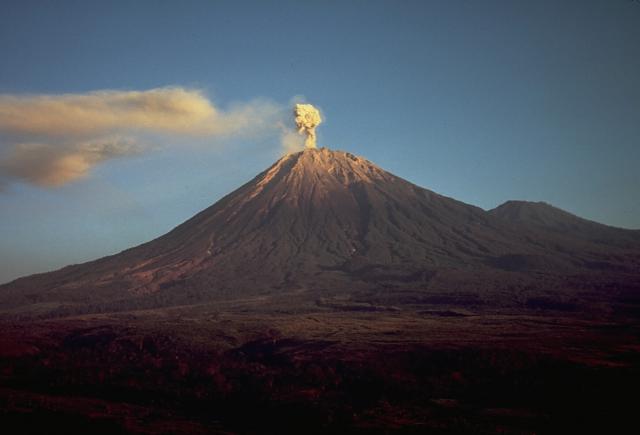
Indonesia , Semeru :
Level of activity at level II (WASPADA). The Semeru volcano (3676 m above sea level) is experiencing a continuous eruption. There are explosive and effusive eruptions, causing lava flows to the south and south-east slopes, and emissions of incandescent rocks around the summit crater.
The volcano is clearly visible until it is covered with fog. The éruptions still occurs. A column of eruption was observed in a thick white color, oriented towards the West with a height of about 200 to 300 meters above the summit. A lava flow is observed in the direction of Besuk Kembar up to 100 – 300 meters (the avalanche center is 1200 m from the crater). The weather is sunny / rainy, the winds are light in the North, North-East, East and West.
According to seismographs, on May 16, 2020, it was recorded:
51 eruption / explosion earthquakes
5 avalanche earthquake
22 emission earthquakes
1 harmonic tremor
1 shallow volcanic earthquake
1 distant tectonic earthquake
1 flood earthquake.
Recommendation:
The community must not carry out activities within a radius of 1 km and in the area up to 4 km in the south-south-east slope sector of the active crater which is an opening area of the active crater of G. Semeru (Jongring Seloko) as a channel for sliding warm clouds.
Be aware of the presence of the lava dome in the Seloko Jongring crater.
VOLCANO OBSERVATORY NOTICE FOR AVIATION – VONA.
Issued: May 17 , 2020
Volcano: Semeru (263300)
Current Aviation Colour Code: ORANGE
Previous Aviation Colour Code: orange
Source: Semeru Volcano Observatory
Notice Number: 2020SMR46
Volcano Location: S 08 deg 06 min 29 sec E 112 deg 55 min 12 sec
Area: East java, Indonesia
Summit Elevation: 11763 FT (3676 M)
Volcanic Activity Summary:
Eruption with volcanic ash cloud at 00h22 UTC (07h22 local).
Volcanic Cloud Height:
Best estimate of ash-cloud top is around 13363 FT (4176 M) above sea level, may be higher than what can be observed clearly. Source of height data: ground observer.
Other Volcanic Cloud Information:
Ash cloud moving to north
Remarks:
Seismic activity is characterized by eruption, avalanche and gas emission earthquakes.
Source : PVMBG , Magma Indonésie .
Photos : Thomas J. Casadevall, USGS — Smithsonian – Global Volcanism Program , PVMBG.
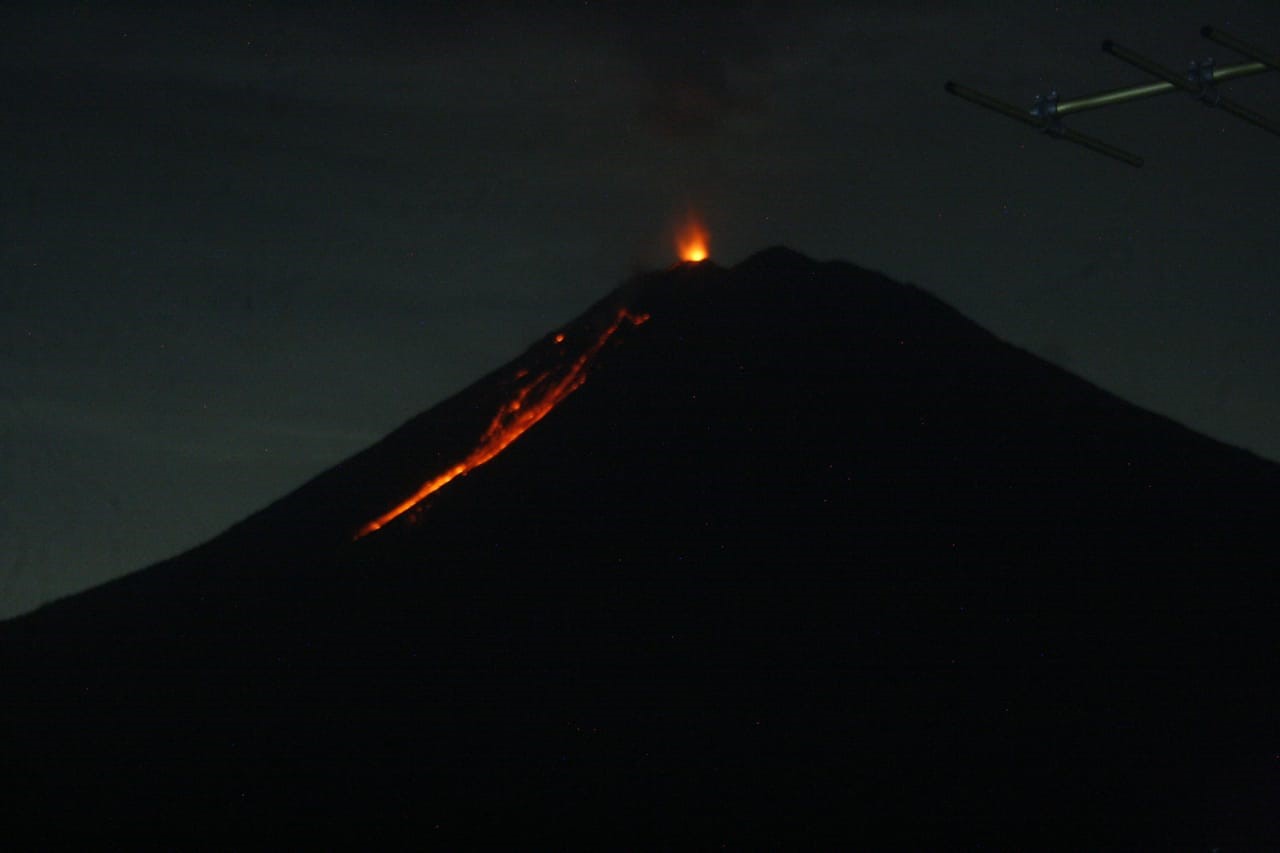
Ecuador , Sangay :
DAILY REPORT OF THE STATE OF SANGAY VOLCANO, Saturday May 16, 2020.
Surface activity level: High, Surface trend: No change.
Internal activity level: High, Internal trend: No change.
Seismicity: From May 15, 2020, 11:00 a.m. to May 116, 2020, 11:00 a.m .:
Long Period Type (LP): 13 events
Explosions: (EXP): 57 events.
Rains / lahars: From dawn until now, light rains have been recorded in the area.
** In the event of heavy rain, the accumulated volcanic material can be remobilized, generating mudslides and debris (secondary lahars) in the Volcán, Upano and other tributary rivers.
Emission / ash column: No emission was observed, however, during the last 24 hours, the Washington VAAC reported 3 alerts of ash emissions, recorded on satellites, the direction of dispersion varied from West to Southwest, the maximum height recorded was 1170 meters above the level of the crater
Other monitoring parameters: No changes.
Observations: For the past 24 hours, the volcano has remained cloudy, making it impossible to have visual records of activity at the surface level. The counting of the events is incomplete because there is seismic data until 8:11 pm TL, yesterday, due to problems of transmission of the station. Once the connection is restored, the number and recording of internal activity events will be updated.
Niveau d’alerte: jaune.
Source : IGEPN.
Photo : IGEPN .
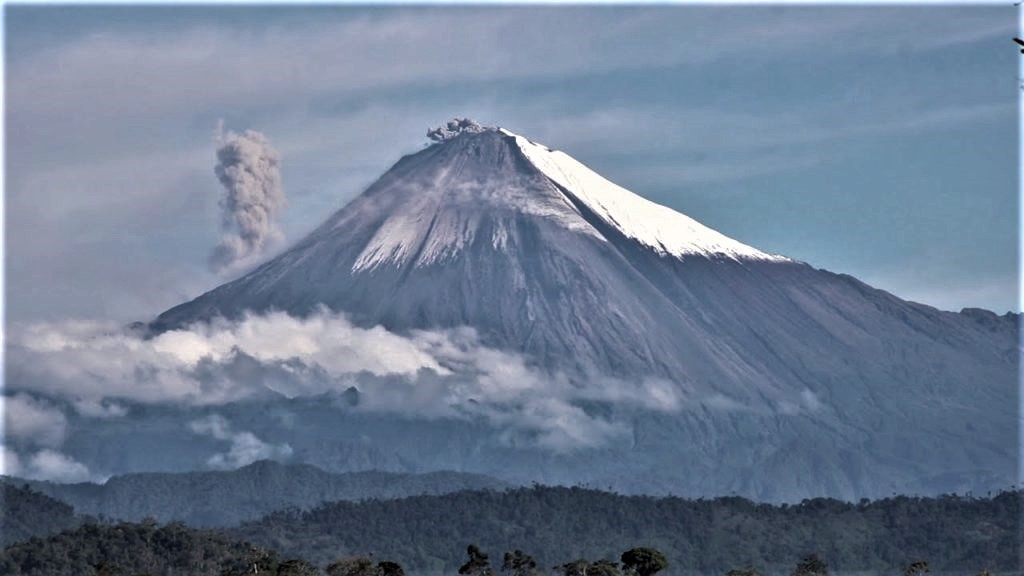
Mexico , Popocatepetl :
May 15, 11:00 a.m. (May 15, 4:00 p.m. GMT)
In the past 24 hours, the Popocatépetl volcano monitoring system has identified 177 exhalations accompanied by volcanic gases and sometimes small amounts of ash. In addition, 118 minutes of tremors and four minor explosions were recorded yesterday at 12:06 p.m., 2:13 p.m., 3:15 p.m. and 8:00 p.m.
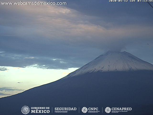
During the morning, the constant emission of volcanic gases was observed. At the time of this report, due to cloudy conditions, there is partial visibility towards the crater, any emission of water vapor, gas and ash will disperse in the northeast direction.
CENAPRED urges not to get near the volcano and especially the crater, because of the danger involved in the fall of ballistic fragments and, in the event of heavy rain, to move away from the bottom of the ravines because of the danger of mud and debris.
The Popocatépetl volcanic alert signaling light is in YELLOW PHASE 2.
Source : Cenapred .