July 22 , 2020.
Italy / Sicily , Etna :
Weekly bulletin from July 13, 2020 to July 19, 2020 (issue date July 21, 2020)
SUMMARY OF ACTIVITY STATUS:
In the light of surveillance data, it is highlighted:
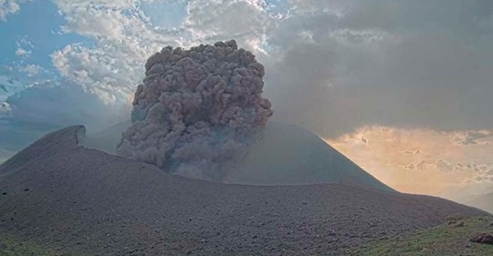
1) VOLCANOLOGICAL OBSERVATIONS: Volcanic activity characterized by degassing and continuous explosive activity of the upper craters with formation of ash clouds. It is not possible to exclude an evolution of the phenomena towards a more energetic activity.
2) SEISMOLOGY: Moderate fracture seismicity. Amplitude of the tremor on the average values.
3) INFRASON: Low infrasound activity
4) DEFORMATIONS: The Etna soil deformation monitoring networks did not show any significant changes last week.
5) GEOCHEMISTRY: The flow of SO2 is at a medium-low level.
Soil CO2 flux measurements (EtnaGas) showed an increase from July 15th reaching a peak of high values (0.85) on July 17th. On July 20, they show a slight decrease (0.76).
The partial pressure of dissolved CO2 does not show significant variations.
C / S values are average values (last measurement dated 07/17/2020)
He isotopic values confirm the downward trend (last update 07/01/2020).
6) SATELLITE OBSERVATIONS: The thermal activity in the summit area is at a medium-low level
VOLCANOLOGICAL OBSERVATIONS
The monitoring of volcanic activity at the summit craters of Etna, during the week in question, was carried out by analyzing the images of the network of surveillance cameras of the INGV section of Catania, Etneo Observatory (INGV- OE).
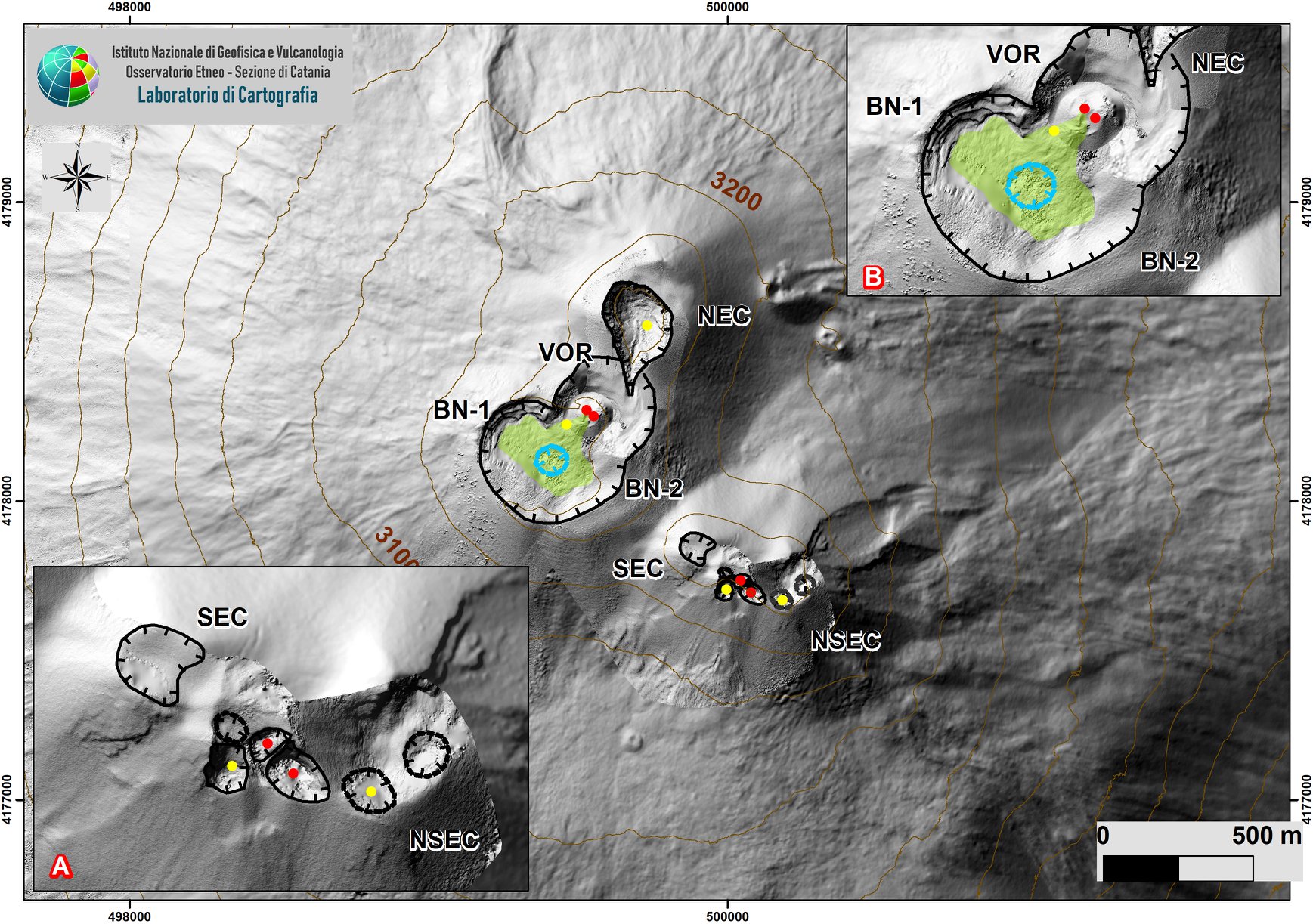
Upper Etna area with zoom of sectors linked to the SEC-NSEC system (A) and BN and VOR craters (B). Indented black lines indicate the edge of the summit craters (BN: Bocca Nuova, with northwest (BN-1) and southeast (BN-2) depressions; VOR: Voragine; NEC: northeast crater; SEC : south-eastern crater and NSEC: new south-eastern crater. The indented blue line indicates the depression inside the Bocca Nuova. Yellow circles = degassing vents; red = active.
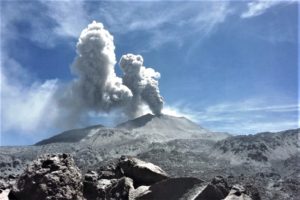
Throughout the week, mainly intra-crater explosive activity was observed which affected the New Southeast Crater (NSEC) and Voragine (VOR) with low ash emissions which quickly dispersed at high altitude and with material launches. above the edges of the crater.
On July 15, surveillance cameras recorded a modest increase in explosive activity showing Strombolian activity of varying nature affecting the aforementioned craters, with ash emissions that dispersed rapidly near the summit area and with shreds of lava projected outside, above the edges of the crater.
During the period in question, the other summit craters were mainly characterized by outgassing activities.
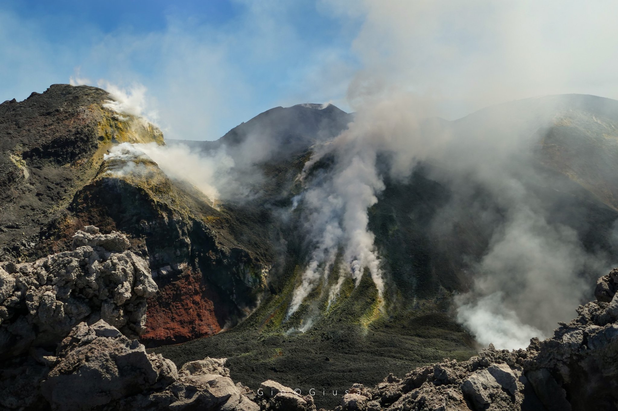
Between steam and gas from the edge of the Bocca Nuova Crater, one of the 4 Summit Craters of Etna.
Volcanic tremor:
During the week in question, the average amplitude of the volcanic tremor remained at average levels with some oscillations. The sources of the volcanic tremor were located near the New Southeast Crater area at a depth of about 2800-3000 m above sea level.
Source : INGV .
Photos : Boris Behncke , Gio Giusa .
Peru , Ubinas :
Analysis period: July 13-19, 2020, Arequipa, July 20, 2020
Alert level: ORANGE
The Peruvian Geophysical Institute (IGP) reports that the Ubinas volcano (Moquegua region) continued to record during the analysis period a slight increase in its seismic activity; therefore, it is suggested to the authorities and the population to keep an eye on the bulletins published by the IGP.
During the analysis period, the occurrence of 53 earthquakes with a magnitude less than M1.4 were identified, events that would be related to rock breaking processes that occur inside the volcano. On average, the occurrence of 8 earthquakes per day was recorded. Likewise, 12 seismic signals were recorded, associated with movements of volcanic fluids (water vapor and gas). There was no seismic activity linked to the rise of the magma.
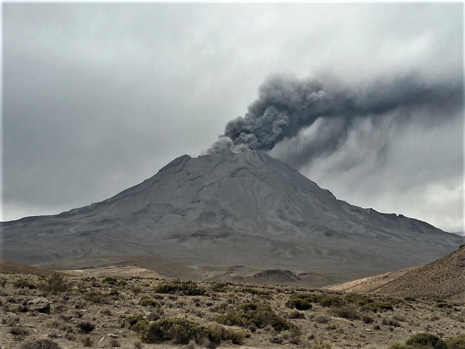
Surveillance cameras recorded columns of gas and water vapor reaching heights of up to 1000 m above the summit of the volcano; these emissions dispersed towards the south-eastern sector of the volcano.
Both the monitoring of the deformation of the volcanic structure and the satellite monitoring through the SENTINEL, OMI-NASA (SO2 gas) and MIROVA (thermal anomalies) systems did not record any anomalies during the period.
RECOMMENDATIONS:
• Stay informed at all times of volcanic activity in the Ubinas.
• Do not approach within a radius of less than 3 km around the crater of the volcano.
• Do not neglect preventive actions in the event of a possible increase in volcanic activity.
Source : IGP
Photo : archive ingemmet.
Italy , Stromboli :
Analysis period: July 13-19, 2020, Arequipa, July 20, 2020
SUMMARY OF ACTIVITY STATUS
In the light of surveillance data, it is highlighted:
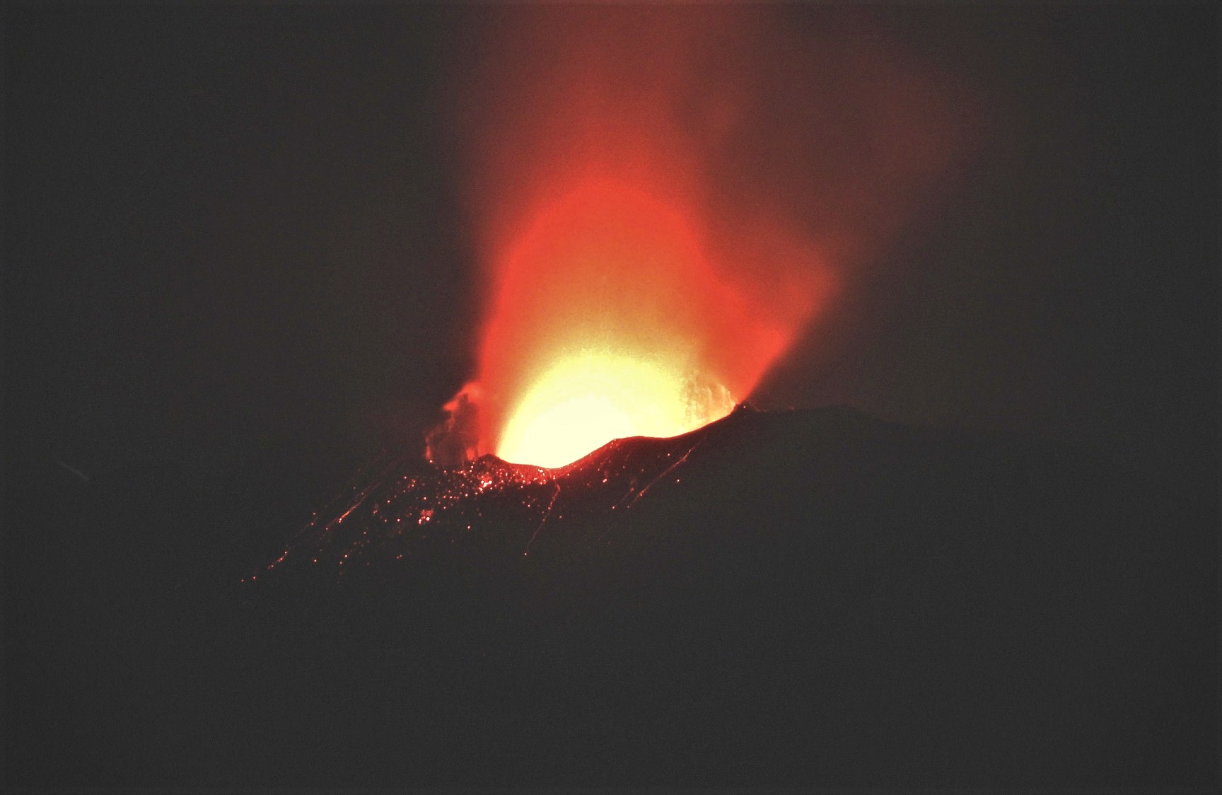
1) VOLCANOLOGICAL OBSERVATIONS: During this period, a normal explosive activity of strombolian type was observed interrupted by an explosive sequence of high energy. The total hourly frequency of explosions fluctuated between average values (14 events / h on July 15-16) and medium-high values (20 events / h on July 13). The intensity of the explosions was variable, from low to high in the North crater area and was low in the Center-South crater area.
2) SEISMOLOGY: At 3:00 am on 07/19, there was an explosion of an intensity greater than normal Strombolian activity.
Subsequently, the explosive activity returned to normal activity.
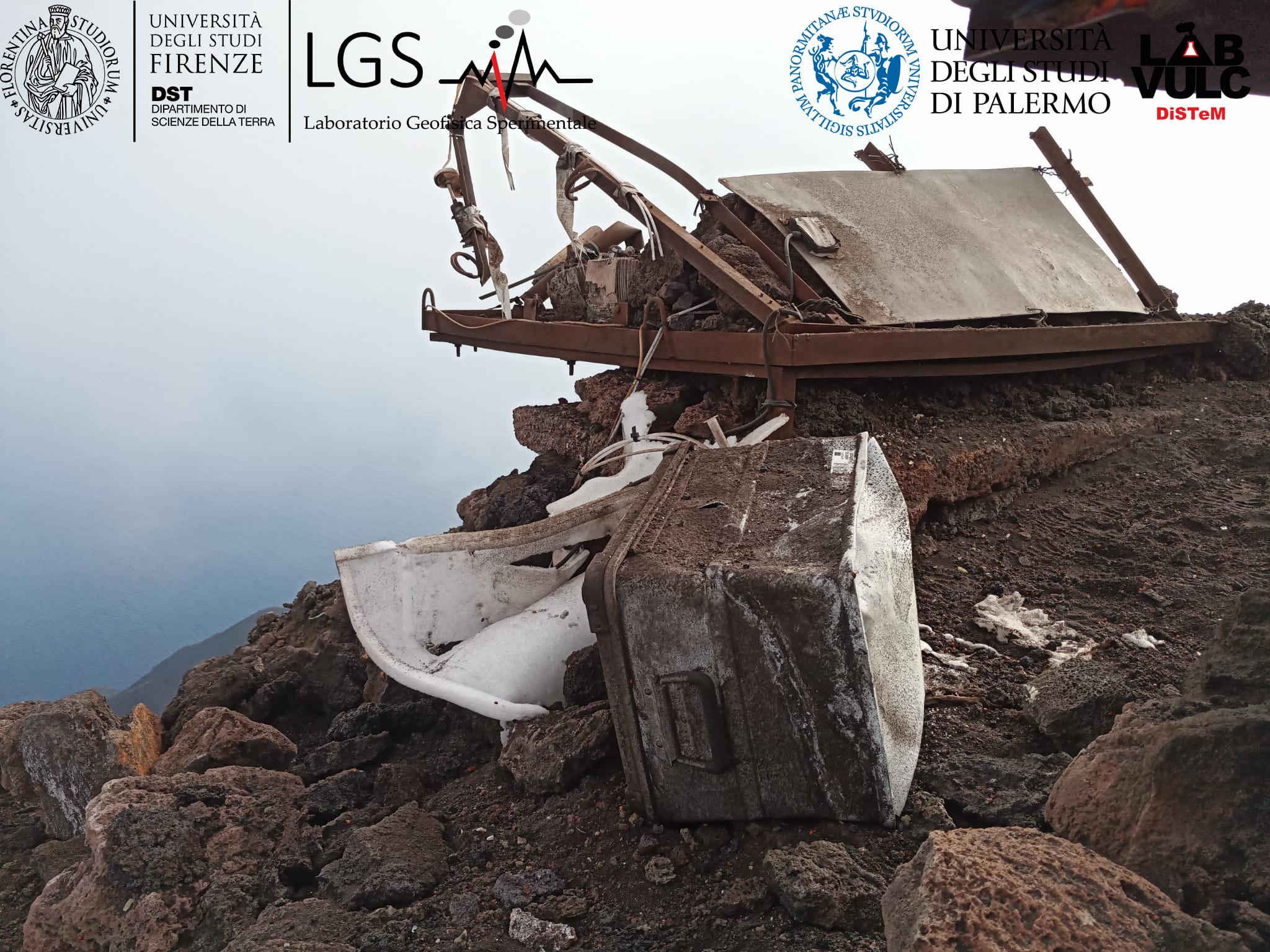
Pizzo multigas station, destroyed by the biggest explosion of July 19, 2020.
4) DEFORMATIONS: The island’s soil deformation monitoring networks did not show significant variations over the period considered. A small transient variation (size of order 10 ^ -8) is detected by the inclinometer of the TDF station in conjunction with the explosive event greater than 17 u.s.
5) GEOCHEMISTRY: The flow of SO2 is at a medium-low level
The CO2 / SO2 value corresponds to the average values.
The isotopic values of He from the last update (07/01/2020) are average values, in line with the previous ones.
6) SATELLITE OBSERVATIONS: The thermal activity in the summit area is at a medium-low level
VOLCANOLOGICAL OBSERVATIONS
During the observation period, the eruptive activity of Stromboli was characterized by the analysis of the images recorded by the surveillance cameras INGV-OE (altitude 190m, Punta dei Corvi, altitude 400 m and Pizzo). It should be noted that the Pizzo’s infrared camera was damaged after the event of July 19. The explosive activity was mainly produced by 3 (three) eruptive vents located in the area of the North crater and by 4 (four) eruptive vents located in the area of the Center-South crater. All the vents are placed inside the depression which occupies the terrace of the crater.
On 07/19/20 from 03:00 UTC, the crater terrace was affected by a high energy explosive sequence that affected the Central and South zone.

The crater terrace seen by the thermal camera located on the Pizzo sopra la Fossa with the delimitation of the crater zones of the Center-South and North zone (respectively ZONE N, ZONE C-S).
Abbreviations and arrows indicate the names and locations of active vents, the area above the crater terrace is divided into three height ranges relating to the intensity of the explosions.
Timeline of the July 19 event.
On 07/19/2020 at 03:00:42 UTC, an explosive sequence begins from the Central South area of the crater terrace. The first impulse which opens the explosive sequence seems to be located at the central mouth and after a few seconds it spreads to the entire South zone, producing most of the pyroclastic material emitted. At 03:01:11 a second explosion and at 03:01:28 a third explosion, of lesser intensity than the first, still occurred in the South sector. The total duration of these two explosions is approximately 35 seconds followed by a few explosions of medium-low energy (between 80 and 150 m high) which end the sequence at 03:04:03. The material produced by the event was distributed radially and reached an altitude of about 500 m. Some of this material dispersed along the Sciara del Fuoco and reached the coast after about 40s since the start of the event.
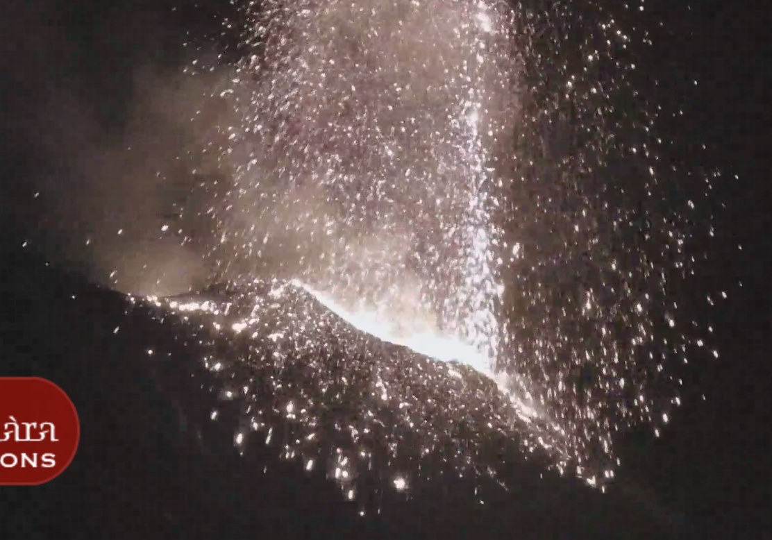
The N1 crater located in the North zone, with two emission points, produced explosions of low to high intensity (the products of some explosions exceeded 200 m in height) emitting coarse materials (lapilli and bombs) which fell in abundance with radial distribution. The N2 mouth showed low intensity explosive activity (less than 80 m in height) emitting fine material (ash) sometimes mixed with coarse material. The average frequency of explosions was between 5 and 9 events / h.
In the Center-South area, the mouth S1, located on the cone overhanging the Sciara, produced low intensity explosions, emitting coarse matter mixed with fine materials while the mouth placed in the crater S2 produced explosions of varying intensity from low to high emitting coarse material mixed with fine material. Another muzzle was observed on July 18 between vents S2 and C. The muzzle located in central area C occasionally produced low intensity coarse material explosions. The frequency of the explosions was between 8 and 11 events / h with the sole exception of July 19 when the frequency of the events was less than 1 event / h (frequency observed after the explosive sequence).
Source : INGV .
Photos : Guide Magmatrek / LGS , webcam .
Nicaragua , Telica :
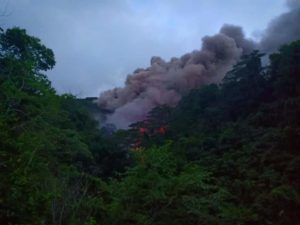
Ineter reports two gas and ash explosions on the Telica volcano.
INETER recorded two small explosions of gas and ash on the Telica volcano, projecting materials 200 meters above the edge of the crater, without affecting the population.
According to Ineter, these explosions are due to the previous obstruction of the conduit, due to small landslides that occur inside the crater. The explosions occurred on Sunday, July 20 at 4:59 p.m. and 5:41 p.m.
As a result of the explosion, the volcanic tremor increased, so that the real-time seismic amplitude (RSAM) increased from 57 to 153 units. The volcanic tremor remains at 144 units, which implies the possibility that other small explosions will occur in the hours or days to come, which do not represent a danger for the population.
Ineter is asking the general population to stay away at least 1.5 kilometers from Telica crater. The authorities are closely monitoring the behavior of this volcano.
Source : 100%noticias.
Photo : webcam Ineter.
Guatemala , Santiaguito :
Height: 2500msnm
Weather conditions: Cloudy
Wind: East.
Precipitation: 19.30 mm.
Activity:
The Caliente Dome is observed with a white fumarole mainly of water vapor at an altitude of 3,000 meters above sea level (9,843 feet), which the wind moves to the west and southeast of the volcanic complex . Weak to moderate explosions are recorded up to 3,400 meters (11,155 feet), with a slight presence of ash in the volcanic perimeter. An incandescence is observed on the crater of the Caliente dome.

The STG3 seismic station records moderate to strong boulder avalanches, constantly observed on the South, South-West and South-East flanks, some reaching the base of the dome, and others accompanied by small pyroclastic flows. Larger pyroclastic flows could be generated. In this stage of activity, flows of blocks and ash or pyroclastic flows of greater magnitude can be generated. (The recommendations of the special bulletin of the Santiaguito volcano 43-2020 remain in force).
Source : Insivumeh .
Photo : Annie Winson , earthobservatory.sg