June 17 , 2020.
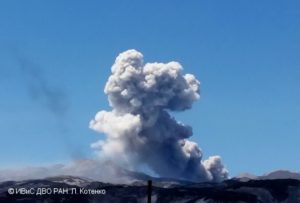
Italy / Sicily , Etna :
Weekly bulletin from June 08, 2020 to June 14, 2020 (issue date June 16, 2020)
SUMMARY OF THE STATUS OF THE ACTIVITY
In light of the monitoring data, it is underlined:
1) VOLCANOLOGICAL OBSERVATIONS: Moderate intra-crater strombolian activity in the New Southeast Crater; sporadic Strombolian explosions with small ash emissions in Voragine.
2) SEISMOLOGY: Seismicity linked to weak fracturing events, high tremor level.
3) INFRASOUND: Moderate infrasonic activity.
4) DEFORMATIONS: The trend of inflation, attributable to the resumption of pressurization of the magmatic system, is again clearly visible in the time series of GNSS data and the changes in the planimetric and altimetric components of the ELAC station (Isola Lachea Acitrezza) have decreased or reversed. The time series of the tilt stations do not show significant variations.
5) GEOCHEMISTRY: The flow of SO2 is at a medium-low level. Soil CO2 flow values are kept at average levels. The partial pressure of dissolved CO2 does not show significant variations. The latest data on the C / S ratio measured at the Voragine crater (sampling on June 12) are average-low values. There is no new data available on the isotopic ratio of helium. The last figure (May 22) concerned medium-high values.
6) SATELLITE OBSERVATIONS: The thermal activity in the upper zone is weak.
VOLCANOLOGICAL OBSERVATIONS
During the week of June 8 to 14, 2020, monitoring of Etna activity was carried out by analyzing images from INGV surveillance cameras, Etneo Observatory (INGV-OE). Observations over a few days were limited due to adverse weather conditions.
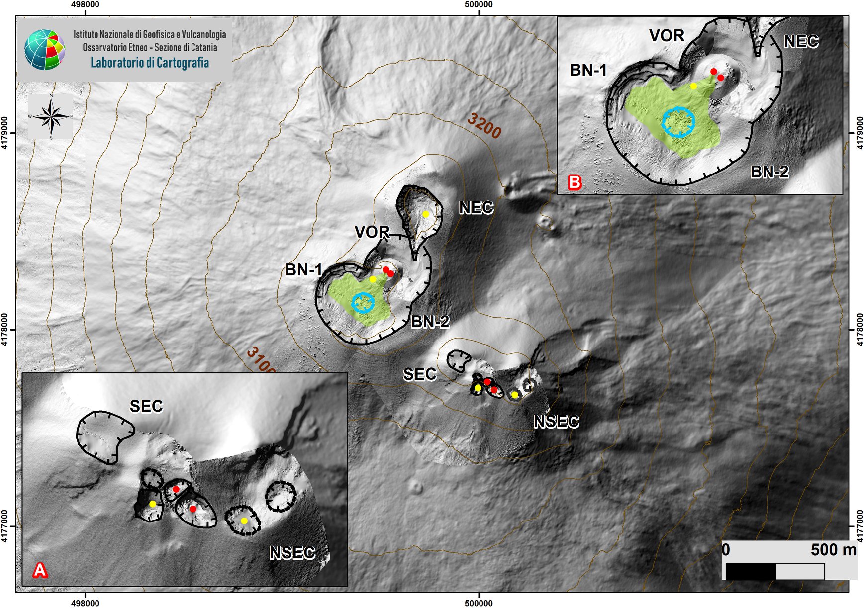
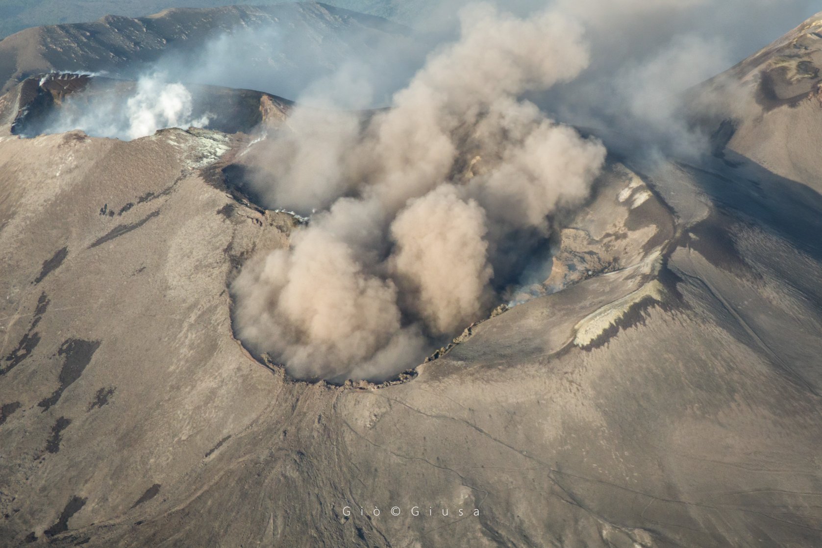
DEM of the summit area of Etna with zoom of the sectors linked to the SEC-NSEC system (A) and craters BN and VOR (B) produced by aerial photogrammetry, which show the intra-crater morphology of the two sectors.
Meanwhile, the eruptive activity in the summit craters of Mount Etna remained at fairly low levels. The usual degassing continued from the open mouths of the Northeast Crater, of Voragine and of the Southeast Craters / New Southeast Craters and of the various fumarolic zones on the edges of the craters.
In particular, in the « saddle cone » area of the New South-East Craters, intra-crater strombolian activity continued, which generated fluctuating eruptions; the jets of incandescent pyroclastic material have rarely passed the edge of the mouth. No ash emission was observed.
The crater of Voragine, after a period without any eruptive manifestation, produced unique explosions accompanied by small ash emissions on June 11 and 12. On the morning of June 14, a sequence of about 10 small explosions took place in the same crater, which launched glowing materials just above the edge of the crater and produced small bursts of ash.
Volcanic tremor: During the week in question, the average amplitude of volcanic tremor remained at high levels). The location of the source of the tremor is located in the area of the New Southeast Craters at shallow depths.
Source : INGV.
Read the whole article : file:///C:/Users/Utilisateur/AppData/Local/Packages/Microsoft.MicrosoftEdge_8wekyb3d8bbwe/TempState/Downloads/BollettinoEtna20200616%20(1).pdf
Photos : Gio Giusa , INGV.
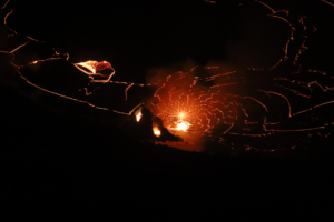
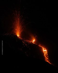
Italy , Stromboli :
Weekly bulletin from June 08, 2020 to June 14, 2020 (issue date June 16, 2020)
SUMMARY OF THE STATUS OF THE ACTIVITY
In light of the monitoring data, it is underlined:
1) VOLCANOLOGICAL OBSERVATIONS: During this period, normal explosive activity of the strombolian type was observed accompanied by degassing and splashing activities. The hourly frequency of explosions fluctuated between average values (11-15 events / h) with the sole exception of June 12 with 16 events / h (medium-high value). The intensity of the explosions varied from low to high in both the North crater area and the Center-South crater area.
2) SEISMOLOGY: The seismological parameters do not present significant variations.
4) DEFORMATIONS: There are no significant variations. During the week, the high frequency GNSS network encountered technical problems at the SVIN reference station which were resolved by ING INGV technicians.

5) GEOCHEMISTRY: The flow of SO2 is at an average level. There is no update available for the CO2 / SO2 value, the last figure (02/09/20) was on the average values. The isotopic ratio of helium dissolved in the aquifer (sampling of 06/09/20) is comparable to the previous figure and remains on average values. There is no update for the flow of CO2 emitted by the soils in the Pizzo area above La Fossa.
6) SATELLITE OBSERVATIONS: The thermal activity in the summit area is at a medium-low level.
VOLCANOLOGICAL OBSERVATIONS.
During the period under observation, the eruptive activity of Stromboli was characterized by the analysis of the images recorded by the surveillance cameras of the INGV-OE (altitude 190 m, Punta Corvi, altitude 400 m and Pizzo) and from data collected during an inspection carried out on June 13. Due to the unfavorable weather conditions of June 9 and 10, observation of the explosive activity was limited.
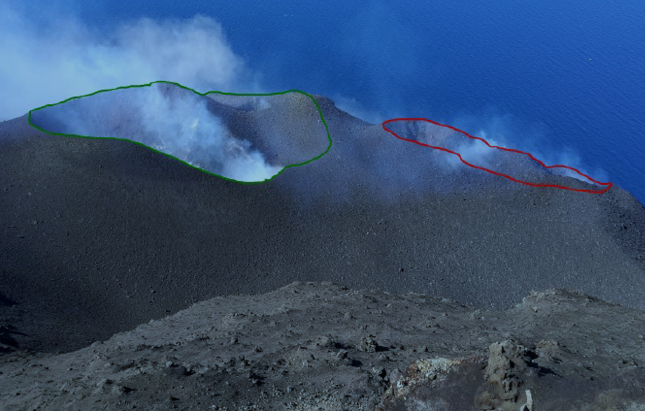
The crater terrace seen by the thermal camera located on Pizzo sopra la Fossa with the delimitation of the crater zones of the Center-South and North zone (AREA N, AREA C-S respectively). Abbreviations and arrows indicate the names and locations of the active vents, the area above the crater terrace is divided into three height ranges related to the intensity of the explosions.
On June 8, 9 and 10, the group of cameras from the operational area of the instrumental surveillance networks of volcanic phenomena at the Etneo Observatory in Catania led a campaign to restore and maintain observation and data transmission systems , damaged during the paroxysmal event of July 3, 2019. In detail, an infrared camera was installed at Pizzo sopra la Fossa and maintenance was carried out on the infrared camera located at an altitude of 190 m.
During the inspection carried out on the morning of June 13, additional data was collected for the morphological characterization of the crater terrace and the explosive activity. The crater N1 consists of two mouths: the northernmost one which produces an intense explosive activity emitting coarse materials, whose products fall on the plate and the other mouth which produces a pyroclastic material of modest volume which falls on the Sciara. Crater N2 is a well-structured cone with a mouth on its south-eastern flank (similar to that observed last February). Its explosive activity produces fine materials (ashes) sometimes mixed with coarse materials. The mouth S1 is a cone, in which no activity has been observed while the crater S2 is a much larger and deeper cone than in February, the edge of which includes the central zone C with two mouths, one of which is deep which produces swelling / splashing activity. In the afternoon of June 15 and 16, the detonations as well as the air movements, probably coming from N1, were felt until the town of Stromboli. It must be considered that the phenomenon was probably accentuated by the direction of dispersion of the wind plume towards the area.
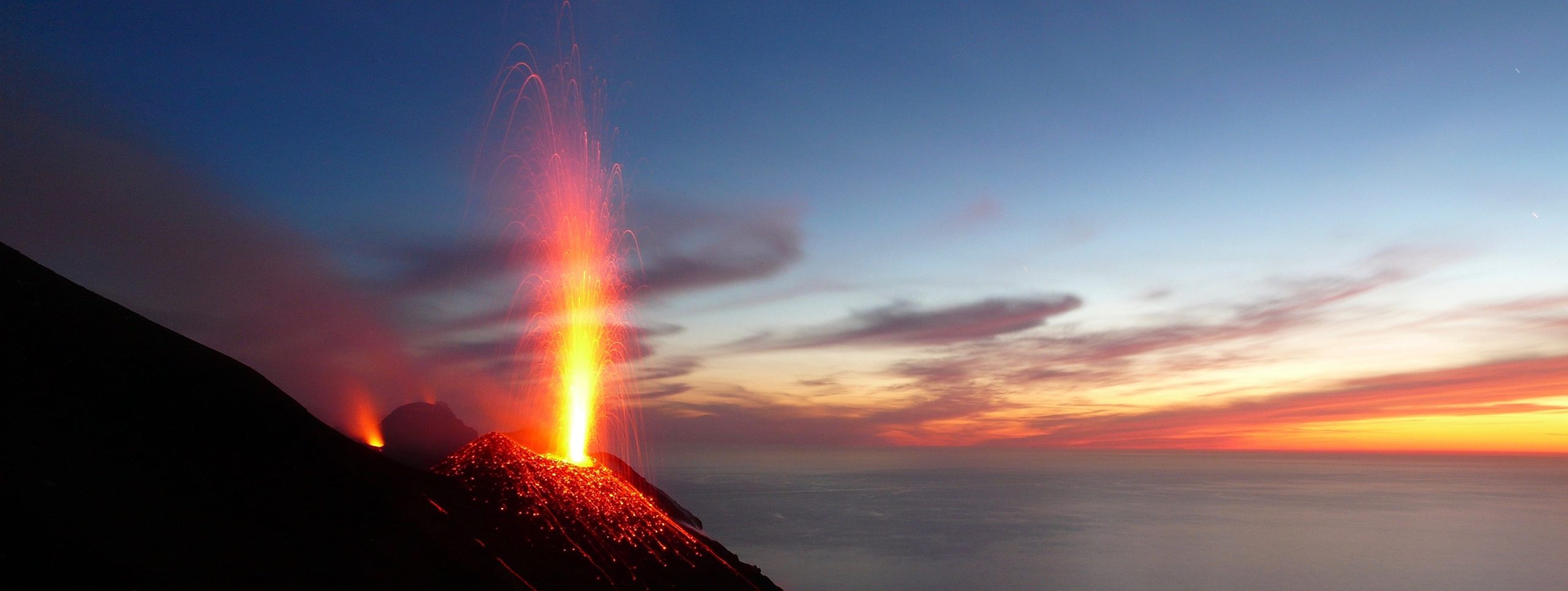
As for the intensity of the explosive activity, the crater N1, with two mouths, located in the North zone, produced mainly explosions of medium to high intensity (the products of many explosions exceeded 150 m in height) emitting coarse materials (lapilli and bombs) which fell abundantly with a radial distribution. The N2 mouth showed an explosive activity of low intensity (less than 80 m in height) emitting fine materials (ashes) sometimes mixed with large ones. The average frequency of explosions was between 7 and 10 events / h. In the Center-South zone, the mouth S1 located on the cone facing the Sciara produced low intensity explosions of fine material while the mouth located in the crater S2 produced low to high explosions emitting materials mainly fine. The two vents located in the Center zone produced an intense activity of splashes continuously interrupted by explosions of coarse materials of low intensity. The frequency of the explosions was between 2 and 6 events / h.
Source : INGV .
Read the whole article : file:///C:/Users/Utilisateur/AppData/Local/Packages/Microsoft.MicrosoftEdge_8wekyb3d8bbwe/TempState/Downloads/BollettinoStromboli20200616%20(1).pdf
Photos : Stromboli adventures , INGV.
Japan , Nishinoshima :
The island of Nishinoshima continues its activity.
The uninhabited volcanic island of Nishinoshima, located nearly 1,000 km southeast of Tokyo, has seen an increase in the number of explosions in recent days. The current eruption started in mid-December 2019, which was the fourth eruptive phase since 2013, the same eruption during which a new island had been formed, covering the remains of the old island created by the first reported eruption in 1973.
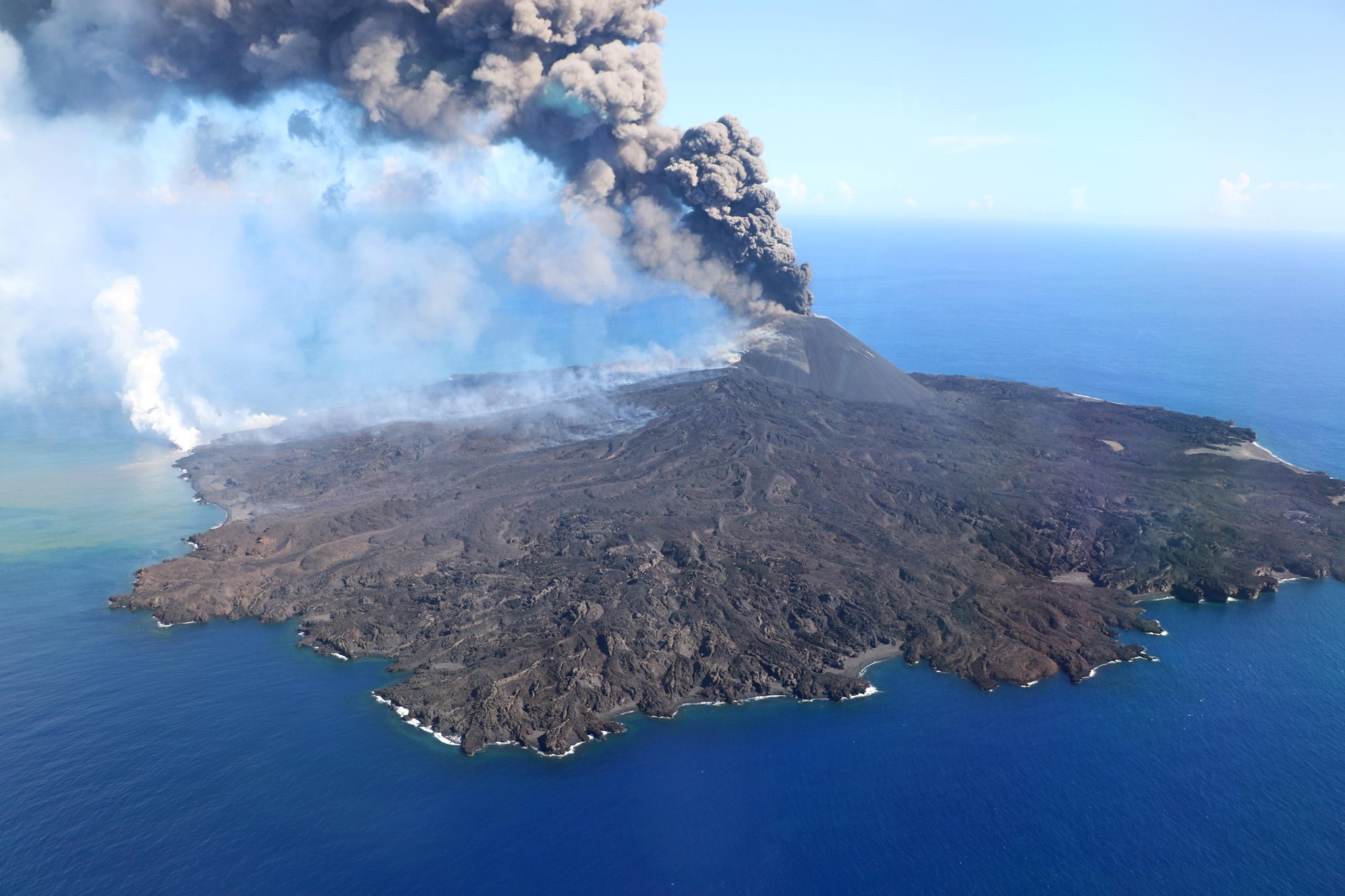
The latest bulletins from the Japan Meteorological Agency, on the state of the volcano, indicate that since June 12, 2020, explosive activity has been observed through the Himawari satellite, pulses of ash mainly and now coming from only one active crater. The materials rise 2.6 kilometers above the point of emission, dispersing east. In the images, you can see the deposits of particulate or fragmented materials (ashes) accompanied by small volcanic bombs on the slopes ejected from the small crater.
The activity on Nishinoshima was continuous during this last eruptive phase. Effusive activity predominated during this period. The lava flows were almost persistent and in all directions, reaching the waters of the Pacific Ocean, confirmed by thermal images showing anomalies considered high to very high during the recent eruption.
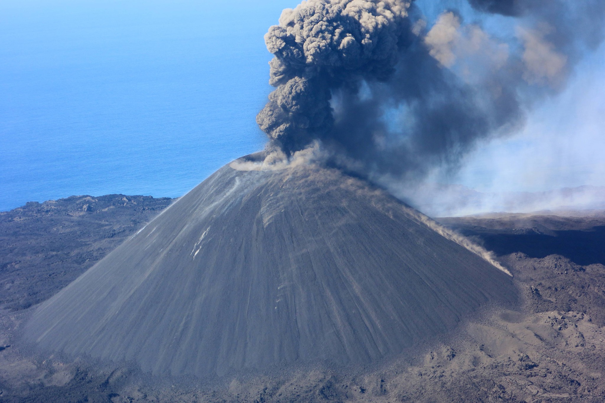
Authorities maintain a 2.5 km restriction radius from the crater, due to the emission of ash and scattered lava flows on the island, with a trajectory towards its coasts. So far, there has been no impact.
Source : EarthQuakesTime
Photos : Japanese Coast Guard via Sherine France .
Iceland , Grímsvötn :
Evidences that Grímsvötn volcano is getting ready for the next eruption
The Scientific Advisory Board met last week to review the current volcanic unrest at Reykjanes and to report on the latest measurements done at Grímsvötn volcano. June 16 , 2020.
The Scientific Advisory Board met last Wednesday, 10 June, to review the on-going volcanic unrest at Reykjanes and to discuss the latest measurements done at Grímsvötn volcano. The meeting was attended by scientists from the Icelandic Meteorological Office, University of Iceland – Institute of Earth Sciences, HS-Orka, Iceland Geosurvey and the Environmental Agency of Iceland. Representatives from the Civil Protection, ISAVIA-ANS and Police Dept. of the South-Iceland also participated.
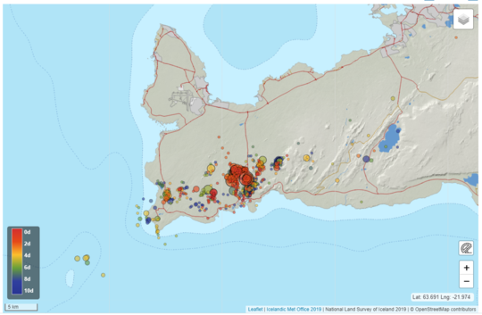
Overview of the seismicity around Grindavík since Friday last week. The M3.5 earthquake was detected on Saturday 13 June
An inflation started again close to Grindavík
In mid-May deformation data (GPS and InSAR measurements) started to show again signs of inflation, suggesting that a third intrusion since the beginning of this year is occurring west of Thorbjörn. The intrusion began around mid of May but the seismic activity started to increase toward the end of the month (30 May). About 2000 earthquakes have been detected since then and several events are located East of Thorbjörn, few kilometers North of the town of Grindavík. The largest earthquake of this swarm occurred on Saturday 13 June and had a magnitude of 3.5.
Since the beginning of the volcanic unrest, in January this year, the total uplift measured in the area is assessed to be around 12 cm. Between the inflation periods, slight deflation has been observed, probably reflecting the cooling of the intruded magma or the interaction with the geothermal system. Numerical modelling results show that this third intrusion is occurring roughly in the same area as the previous ones, i.e. at about 1 km West of Thorbjörn, at a depth of 3-4 km, with a width of few hundreds of meters and oriented NE-SW for about 6 km. The estimated median volume of magma accumulated during this third intrusion episode is estimated to be 1.2 million m3. The seismic activity is occurring over an area larger than the extension of the intrusion itself and this is probably due to the stress change induced to the crust which affects a wider sector of the peninsula…/…
Evidences that Grímsvötn volcano is getting ready for the next eruption :
At the SAB meeting the status of Grímsvötn volcano was also discussed, as the Earth Science Institute and the Icelandic Meteorological Office had new measurements performed in the beginning of June.
During its active period, as it is since the eruption in 1996, Grímsvötn erupts on average each 5-10 years. The last eruption occurred in 2011 and it was a fairly large and powerful event. Between eruptions, the deformation data indicate the gradual accumulation of new magma at depth and the increased pressure in the system. In the last weeks scientists from the IMO measured SO2 in the southwest corner of the caldera in Grímsvötn, close to where the last eruptions in 2004 and 2011 took place. “This is the first time that we measure so much SO2 at a volcano in Iceland that is not in an eruptive phase and its presence is indicative of magma at shallow level”, says Melissa Anne Pfeffer, specialist at the IMO who participated in the trip on Vatnajökull in these last days. In addition to the high level of SO2, Melissa reports also that the area where geothermal activity can be detected at the surface of the volcano has notably increased.

Specialist of the Icelandic Meteorological Office performing gas measurements in Grímsvötn in the recent days. This picture is taken nearby the place where the last eruption in 2011 took place. (Photo: IMO/Melissa Anne Pfeffer)
In 1953, Sigurður Þórarinsson suggested a correlation between jökulhlaup (glacial floods) and eruptions in Grímsvötn. When the pressure in the volcanic system is increased due to magma accumulation and if a large volume of water is stored in the lake, the pressure release following the removal of water during a flood could facilitate the magma rising to the surface and trigger, in this way, an eruption. This kind of scenario has occurred several times in Grímsvötn, the last time in 2004, but also in 1934 and 1922.
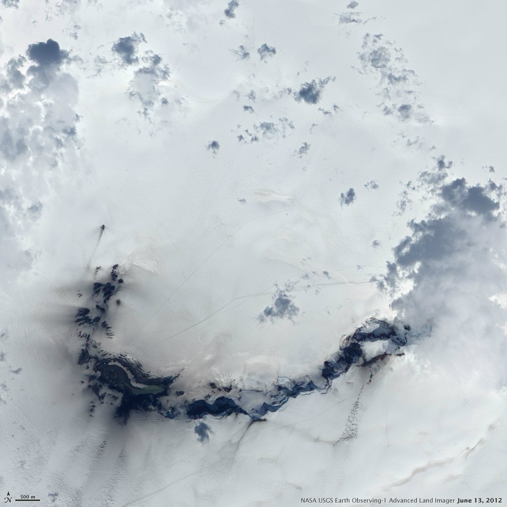
Satellite image in June 2012 of the Grímsvötn subglacial caldera with the Grímsfjall and the subglacial lake in the open air at the bottom of the image following the 2011 eruption.
Chances of an eruption starting at the end of a glacial flood (jökulhlaups) :
The current conditions of Grímsvötn volcano are such that the water level is rather high and the pressure in the magma chamber below the caldera has reached values comparable to those prior to the last eruption. Therefore, the possibility of an eruption triggered by a glacial flood, which could occur in the coming weeks or months, has to be considered. However, this may not be the case, and the next glacial flood may not lead to an eruption.
To discuss further the current status of Grimsvötn volcano and the latest observations, the Scientific Advisory Board will meet again on June 18.
Source : Vedur is.
Read the whole article : https://en.vedur.is/about-imo/news/evidences-that-grimsvotn-volcano-is-getting-ready-for-the-next-eruption
Photos : Vedur is , Visit Reykjanes , OMI / Melissa Anne Pfeffer , NASA’s Earth Observatory .