February 27 , 2020.
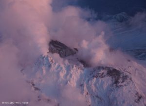
Alaska , Great Sitkin :
AVO/USGS Volcanic Activity Notice
Current Volcano Alert Level: ADVISORY
Previous Volcano Alert Level: NORMAL
Current Aviation Color Code: YELLOW
Previous Aviation Color Code: GREEN
Issued: Wednesday, February 26, 2020, 11:58 AM AKST
Source: Alaska Volcano Observatory
Location: N 52 deg 4 min W 176 deg 6 min
Elevation: 5709 ft (1740 m)
Area: Aleutians
Volcanic Activity Summary:
Over the past month, earthquake activity has increased at Great Sitkin Volcano and is now above background levels. Thus, AVO is increasing the Aviation Color Code to YELLOW and the Alert Level to ADVISORY. There has been no evidence of eruptive activity in geophysical data streams or in satellite observations.
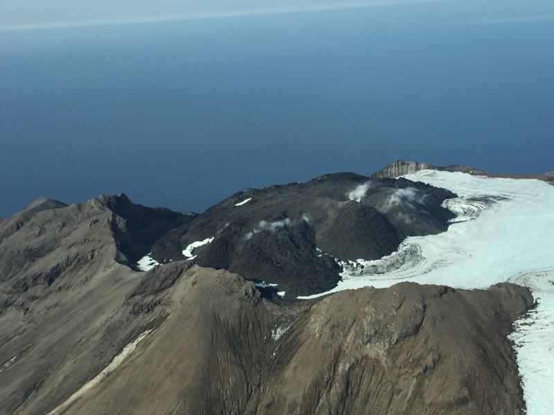
View of the summit dome at Great Sitkin during a gas flight. Very weak diffuse degassing observed all around the margins of the dome and also within the small crater on top. View is roughly to the west. Kanaga volcano is visible in the distance in the upper left.
Great Sitkin is monitored with a local real-time seismic network, which will typically allow AVO to detect changes in unrest that may lead to an explosive eruption. Rapid detection of an ash-producing eruption would be accomplished using a combination of seismic, infrasound, lightning, and satellite data.
Recent Observations:
[Volcanic cloud height] n/a
[Other volcanic cloud information] n/a
Remarks:
Great Sitkin Volcano is a basaltic andesite volcano that occupies most of the northern half of Great Sitkin Island, a member of the Andreanof Islands group in the central Aleutian Islands. It is located 43 km (26 miles) east of the community of Adak. The volcano is a composite structure consisting of an older dissected volcano and a younger parasitic cone with a 3-km-diameter summit crater. A steep-sided lava dome, emplaced during an eruption in 1974, occupies the center of the crater. Great Sitkin erupted at least three times in the 20th century, most recently in 1974. That eruption produced at least one ash cloud that likely exceeded an altitude of 25,000 ft above sea level. A poorly documented eruption occurred in 1945, also producing a lava dome that was partially destroyed in the 1974 eruption. Within the past 280 years a large explosive eruption produced pyroclastic flows that partially filled the Glacier Creek valley on the southwest flank.
Source : AVO.
Photo : Clor, Laura ( June 2019) , Clum, Dave ( September 2018 ).
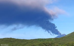
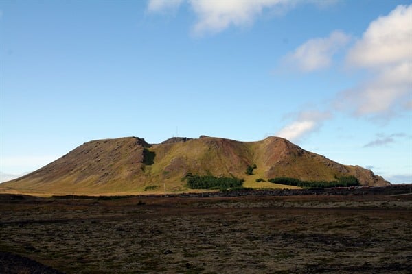
Iceland , Thornbjorn / Grindavík :
63.85°N, 22.566°W
Elevation 140 m
On 25 February IMO reported that seismic activity at Reykjanes, in an area N of the town of Grindavík, had significantly decreased during the previous few days, and inflation was not detected in GPS and InSAR data. The Aviation Color Code was lowered to Green. Preliminary data suggested a small deflation signal beginning mid-February, though further analysis was needed for confirmation. The report warned the public not to explore lava tubes in the Eldvörp area as gas measurements showed a dangerous level of oxygen depletion; there are no pre-unrest measurements existing for comparison.
Seismic activity near Grindavík
Earthquake activity near Thorbjorn has significantly decreased in the last days. Uplift is no longer being observed, which is likely due to the halt of magma inflow. Indications show a minor subsidence from the middle of February but as of now it is too early to interperate the data. The next meeting of the scientific council of Civil Protection will be on Tuesday March 12th.
Source: GVP ,Icelandic Met Office (IMO) .
Photo : Visit Reykjanes.
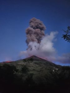
Japan , Sakurajima :
31.593°N, 130.657°E
Elevation 1117 m
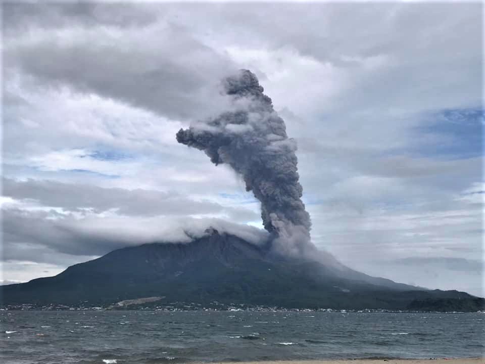
JMA reported that during 17-25 February there were 34 explosions and 19 non-explosive eruptive events detected by the Minamidake Crater (at Aira Caldera’s Sakurajima volcano) seismic network. Ash plumes rose as high as 2.4 km above the crater rim and material was ejected 600-1,100 m away from the crater. Crater incandescence was visible every night. The sulfur dioxide emission rate was elevated at 1,900 tons/day on 20 February. The Alert Level remained at 3 (on a 5-level scale).
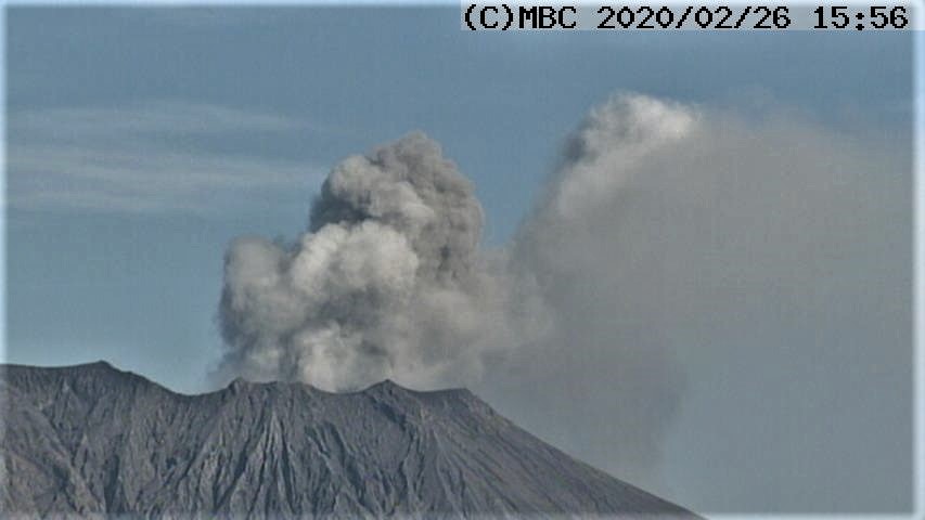
The seismic network record 73 volcanic earthquakes and 63 tremors associated with the eruptions during the period 21-25 Feb 2020. Incandescence continues to be observed from the crater.
Blocks were ejected as far as 1 km away from Showa crater.
An ash plume rose 7,874 ft (2,400 m) above the summit crater.
The volcano has a large amount of volcanic gas (sulfur dioxide).
The warning bulletin states that ballistic impacts of volcanic bombs and pyroclastic flows could affect an area of about 2 km distance from the craters.
The Aira caldera in the northern half of Kagoshima Bay contains the post-caldera Sakurajima volcano, one of Japan’s most active. Eruption of the voluminous Ito pyroclastic flow accompanied formation of the 17 x 23 km caldera about 22,000 years ago. The smaller Wakamiko caldera was formed during the early Holocene in the NE corner of the Aira caldera, along with several post-caldera cones. The construction of Sakurajima began about 13,000 years ago on the southern rim of Aira caldera and built an island that was finally joined to the Osumi Peninsula during the major explosive and effusive eruption of 1914. Activity at the Kitadake summit cone ended about 4850 years ago, after which eruptions took place at Minamidake. Frequent historical eruptions, recorded since the 8th century, have deposited ash on Kagoshima, one of Kyushu’s largest cities, located across Kagoshima Bay only 8 km from the summit. The largest historical eruption took place during 1471-76.
Source: GVP ,Japan Meteorological Agency (JMA) , Volcanodiscovery .
Photos : Kagoshima MBC webcam, Koki Arima .
Colombia , Chiles / Cerro Negro :
Weekly activity bulletin of Chiles and Cerro Negro volcanoes
The activity of volcanoes continues at the YELLOW LEVEL ■ (III): CHANGES IN THE BEHAVIOR OF VOLCANIC ACTIVITY.
Following the activity of VOLCANOES CHILE and CERRO NEGRO, the COLOMBIAN GEOLOGICAL SERVICE (SGC) reports that:
During the period evaluated between February 18 and 24, 2020, a slight increase in the seismic occurrence was observed, while the released energy maintained the same levels, compared to the previous period. Note the predominance of earthquakes associated with rock fractures, which were located in the region of influence of the two volcanoes. In general, the earthquakes were located at distances between 0.8 and 6 km, with depths less than 6 km, from the summit of the Chiles volcano (4700 m above sea level) and their maximum local magnitude was 1.5 on the Richter scale. Although this week, their number has decreased compared to previous weeks, the occurrence of earthquakes associated with fluid movements inside the volcanic system continues, with 9% of the total seismicity. These events indicate a change in the behavior of volcanic activity.

The changes recorded by one of the volcanic deformation sensors have continued since September 2019. The other volcanic monitoring parameters did not show significant variations and no manifestation of surface activity was observed.
Source : SGC.
Photo : hablemosdevolcanes.com