February 14 , 2020 .
La Réunion , Piton de la Fournaise :
Activity bulletin for Thursday 13 February at 3.30 p.m. (local time).
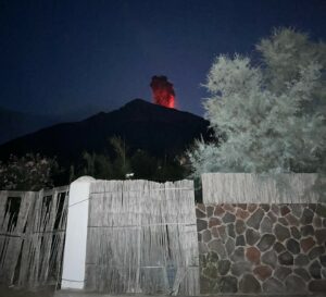
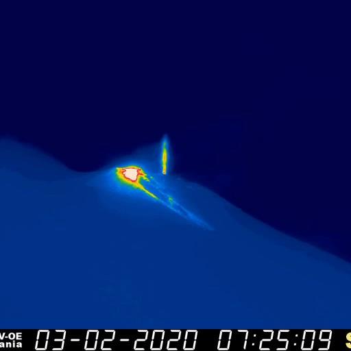
The eruption which started on 02/10/2020 at around 10:50 am local time continues. The intensity of the volcanic tremor (indicator of the intensity of the eruption) has been relatively stable over the past 24 hours (Figure 1).
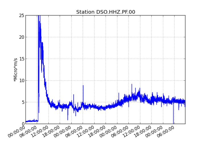
Figure 1: Evolution of the RSAM (indicator of the volcanic tremor and the intensity of the eruption) between 02/10/2020 and 02/13/2020 3:45 p.m. local time (11:45 UT) on the DSO seismological station located at the summit of the volcano. (© OVPF / IPGP).
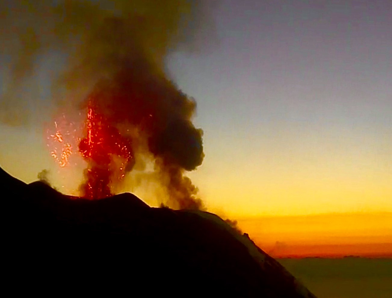
The improvement in weather conditions that occurred today allowed access to the eruptive site on foot as well as an overview. These two missions show that today only the flow descending to the east is still active. Its forehead was located around 12:00 p.m. local time below the Marco crater around 1900 m above sea level, about 6.5 km from the RN2. A cone less than 30 m high, began its construction around the 3 vents remaining active this morning. These vents, located at an altitude of around 2200m, produce modest lava fountains with a height of 10 to 15m (above the volcanic cone under construction).
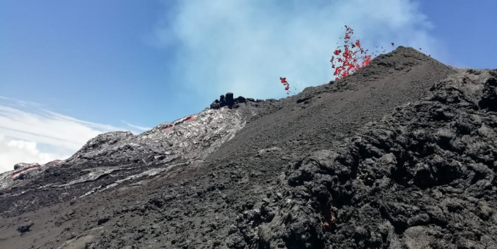
Figure 2: Small lava fountain associated with the cone being built (© OVPF / IPGP).
The estimated surface flows, from satellite data via the HOTVOLC (OPGC – University of Auvergne) and MIROVA (University of Turin) platforms, remain severely disrupted by the bad weather conditions observed around Piton de la Fournaise. The rare measurements carried out, relate to flows lower than 10 m3 / s.
https://www.facebook.com/cynthiaveronofficiel/videos/1448823595293408/
Source : OVPF.
Read the article: http://www.ipgp.fr/fr/ovpf/bulletin-dactivite-jeudi-13-fevrier-a-15h30-heure-locale
Vidéo : Cynthia Véron.
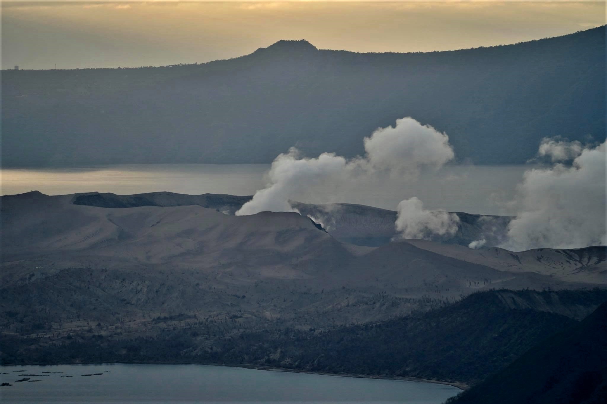
Philippines, Taal :
TAAL VOLCANO BULLETIN 14 February 2020 8:00 AM
This serves as a notice for the lowering of Taal Volcano’s status from Alert Level 3 (decreased tendency towards hazardous eruption) to Alert Level 2 (decreased unrest).
After step-down to Alert Level 3 last 26 January 2020, Taal Volcano’s condition in the succeeding three weeks has been characterized by less frequent volcanic earthquake activity, stabilizing ground deformation of the Taal Caldera and Taal Volcano Island (TVI) edifices and weak steam/gas emissions at the Main Crater. These observations are supported by the following monitoring parameters:
1. Since 26 January, volcanic earthquakes recorded by the Taal Volcano Network (TVN) averaged 141 events/day while the number of significant events recorded by the Philippine Seismic Network across the Taal region declined to 127 events of magnitudes M1.4 to M4.3. The number and energy of tremor and low-frequency events associated with activity in the shallow magma and hydrothermal region beneath the TVI edifice have also diminished. These parameters are consistent with degassing ponded magma rather than active magma transport to and from the shallow magma reservoir beneath TVI.
2. Continuous Global Positioning System (GPS) data from 13 January to 11 February recorded a net subsidence of the Taal Caldera and TVI, following uplift on the northwestern caldera and subsidence of TVI on 12-13 January. Subsidence along thePansipit River Valley, where extensive fissuring occurred, was also recorded by campaign GPS monitoring between 24 and 27 January. The overall ground deformation behavior of Taal Volcano for the above periods indicates post-eruptive subsidence and relaxation of the edifice after the cessation of magma transport, signaled by hybrid earthquake activity, on 18 January.
3. Sulfur dioxide or SO2 flux based on campaign Flyspec data averaged 62 tonnes/day since 26 January, consistent with a weakly degassing shallow magma source, diminished plume activity or absorption of volcanic gas by a recovering lake at the Main Crater and by TVI’s recovering hydrothermal system.
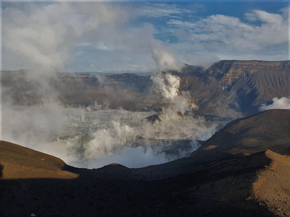
4. Activity in the Main Crater has been characterized by the generation of weak steam-laden plumes, consistent with decreased magmatic unrest.
In view of the above observations, DOST-PHIVOLCS is lowering the alert status of TaalVolcano from Alert Level 3 to Alert Level 2 to reflect the overall decreasing trend in the level of monitoring parameters. Alert Level 2 means that there is decreased unrest but should not be interpreted that unrest has ceased or that the threat of an eruption has disappeared. Should an uptrend or pronounced change in monitored parameters forewarn a potential eruption, the Alert Level may be raised back to Alert Level 3. At such time, people residing within areas at high risk to base surges who have returned after the step-down to Alert Level 2 must therefore be prepared for a quick and organized evacuation. Conversely, should there be a persistent downtrend in monitored parameters after a sufficient observation period, the Alert Level will be further lowered to Alert Level 1.
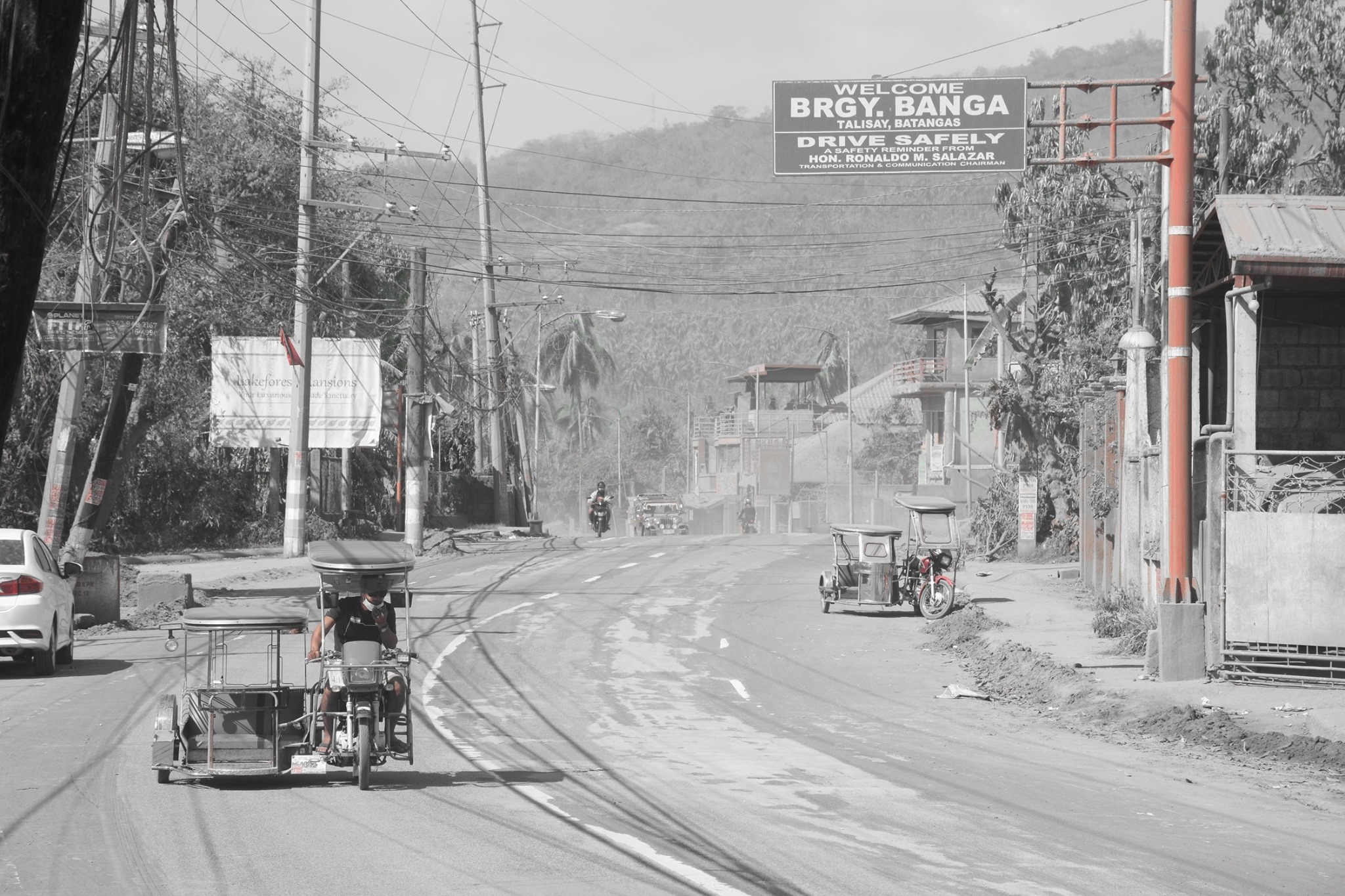
DOST-PHIVOLCS reminds the public that at Alert Level 2, sudden steam-driven or phreatic explosions, volcanic earthquakes, ashfall and lethal accumulations or expulsions of volcanic gas can occur and threaten areas within TVI and along its coast. DOST-PHIVOLCSrecommends that entry into TVI, Taal’s Permanent Danger Zone must be strictly prohibited. Local government units are advised to additionally assess previously evacuated areas within the seven-kilometer radius for damages and road accessibilities and to strengthen preparedness, contingency and communication measures in case of renewed unrest. People are also advised to observe precautions due to ground displacement across fissures, frequent ashfall, and minor earthquakes. Communities beside active river channels particularly where ash from the main eruption phase has been thickly deposited should increase vigilance when there is heavy and prolonged rainfall since the ash can be washed away and form lahars along the channels. Civil aviation authorities must advise pilots to avoid flying close to the volcano as airborne ash and ballistic fragments from sudden explosions and wind-remobilized ash may pose hazards to aircraft.
DOST-PHIVOLCS is closely monitoring Taal Volcano’s activity and any new significant development will be immediately communicated to all stakeholders.
Source : Phivolcs.
Photos : Raffy Tima , William Enriquez , Julien Monteillet .
Italy , Stromboli :
Weekly bulletin from 03/02/2020 to 09/02/2020 (date of issue 11/02/2020)
SUMMARY OF ACTIVITY STATUS
In light of the monitoring data, it is highlighted:
1) VOLCANOLOGICAL OBSERVATIONS: During this period, a normal Strombolian type explosive activity was observed accompanied by degassing and interrupted by an overflow of lava. The hourly frequency of explosions fluctuated between medium-low values (9 events / h on February 5) and high values (22 events / h on February 4). The intensity of the explosions was mainly medium-low in the area of the North crater and medium-high in the area of the Center-South crater.
2) SEISMOLOGY: The seismological parameters do not show significant variations.
4) DEFORMATIONS: The island’s soil deformation monitoring networks did not show any significant variation to report for the period considered.
5) GEOCHEMISTRY: No update is available on the SO2 flow The CO2 / SO2 ratio is established at an average value. No update is available on the isotopic ratio of helium dissolved in the aquifer.
VOLCANOLOGICAL OBSERVATIONS.
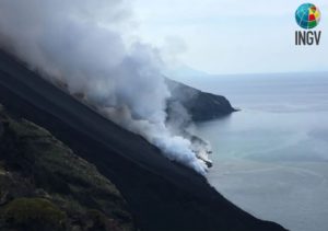
The analysis of the images recorded by the cameras placed at an altitude of 400m, at an altitude of 190m and at Punta dei Corvi made it possible to characterize the eruptive activity of Stromboli. During the reporting period, the explosive activity was mainly produced by at least 3 (three) eruptive vents located in the area of the North crater and by at least 3 (three) eruptive vents located in the area of the Center-South crater . All the vents are located inside the depression which occupies the crater terrace (Fig. 3.1).
On February 3 from 07:20 UTC, a slight overflow of lava was observed from the North area of the terrace of the Stromboli crater. The front of the overflow remained confined in the upper part of the Sciara del Fuoco where, breaking, produced the roll of incandescent material. Due to the unfavorable visibility conditions, the duration of the event is estimated at around 90 minutes.
In the North zone, the explosions were mainly low (less than 80 m high) and medium (less than 150 m high), sometimes high (greater than 150 m high) emitting coarse materials (lapilli and bombs). In many explosions, the fallout covered the outer slopes of the area overlooking the Sciara del Fuoco and many blocks rolled over a few hundred meters before being placed along the Sciara. The average frequency of explosions in the North zone varied between 5 and 8 events / h.
The explosive activity of the Center-South zone produced explosions of coarse materials mixed with fine materials, of medium intensity (less than 150 m high) and high (the products exceeded 250 m high). During certain explosions, the products fell back into the upper part of the Sciara. The frequency of explosions in the Center-South zone varied between 3 and 14 events / h.
The amplitude of the volcanic tremor showed generally medium-low values. The medium-high values, visible on the graph at the start of the week, are linked to bad weather and sea conditions.
Source : INGV.
Read the whole article : file:///C:/Users/Utilisateur/AppData/Local/Packages/Microsoft.MicrosoftEdge_8wekyb3d8bbwe/TempState/Downloads/BollettinoStromboli20200211%20(1).pdf
Photos : INGV , Webcam.
Hawaii , Mauna Loa :
19°28’30 » N 155°36’29 » W,
Summit Elevation 13681 ft (4170 m)
Current Volcano Alert Level: ADVISORY
Current Aviation Color Code: YELLOW
Activity Summary:
Mauna Loa Volcano is not erupting. Rates of deformation and seismicity have not changed significantly over the past week and remain above long-term background levels.
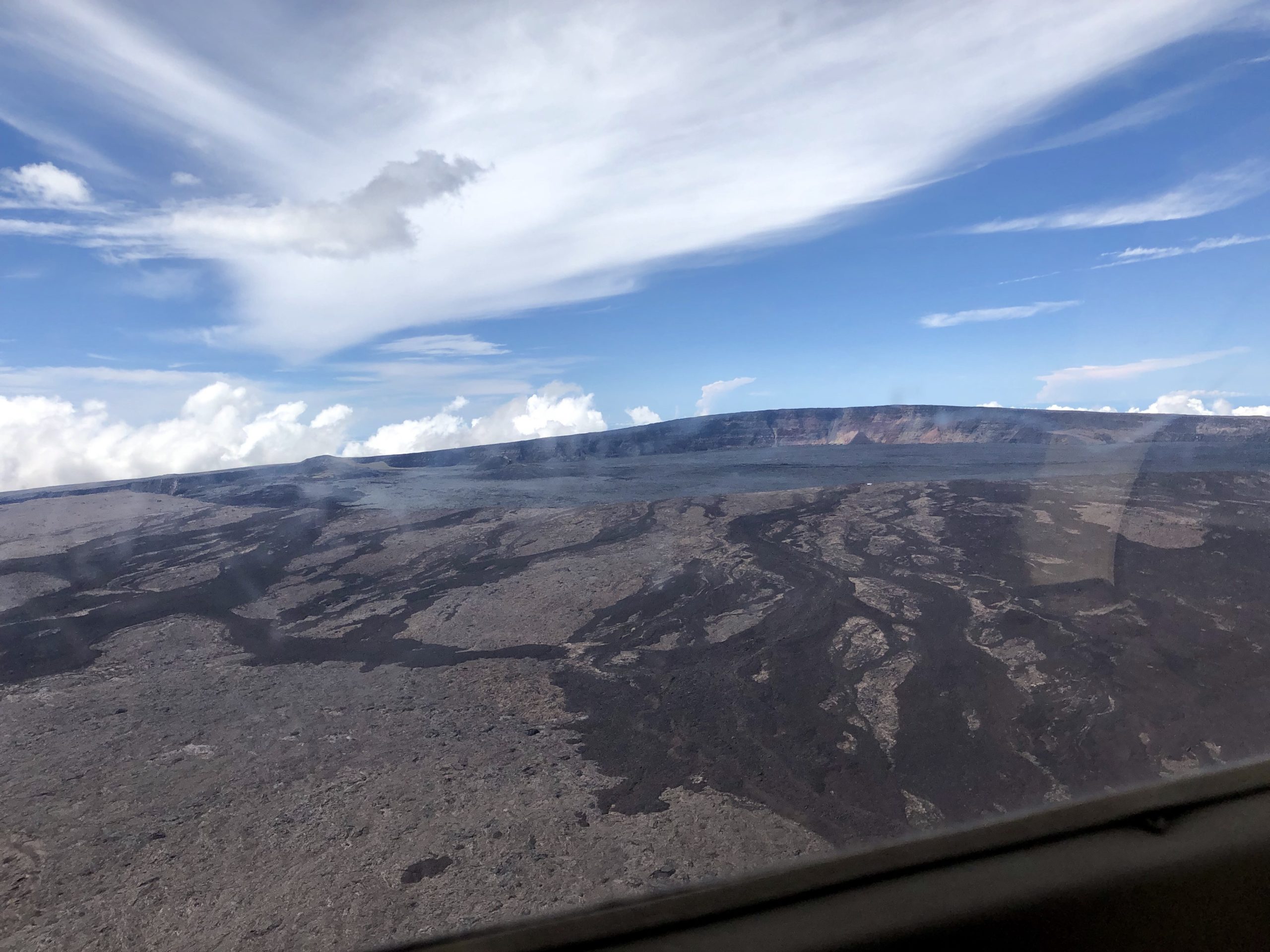
Civil Air Patrol captured this aerial image of Mauna Loa’s summit caldera, Moku‘āweoweo, on Sunday, October 20, 2019. The true summit of Mauna Loa is located just to the right of the center of the image, at the highest location above the caldera wall in the background. The cones that formed during the 1940 (right) and 1949 (left) eruptions are visible in the distant left side of the image. Lava flows in the foreground of the image, which flowed in a direction south of the summit of Mauna Loa, were active prior to formation of the summit caldera approximately 1,000 years ago.
Observations:
During the past week, HVO seismometers recorded 31 small-magnitude earthquakes beneath the volcano’s upper elevations. The strongest was a magnitude-2.9 event on 9 February, at approximately 13 kilometers (~8 miles) below the surface – slightly deeper than other earthquakes of the past week. Most events occurred at shallow depths of less than 5 kilometers (~3 miles) beneath the surface of the volcano.
Global Positioning System (GPS) measurements show continued slow summit inflation, consistent with magma supply to the volcano’s shallow storage system.
Gas concentrations at the Sulphur Cone monitoring site on the Southwest Rift Zone remain stable. Fumarole temperatures as measured at both Sulphur Cone and the summit have not changed significantly.
Source : HVO.